Bayshore Gardens, Florida

Last updated

Bayshore Gardens, Florida
Manatee County Florida Incorporated and Unincorporated areas Bayshore Gardens Highlighted.svg
Location in Manatee County and the state of Florida
Coordinates: 27°25′59″N82°34′39″W / 27.43306°N 82.57750°W / 27.43306; -82.57750 [1]
CountryFlag of the United States.svg  United States
State Flag of Florida.svg  Florida
County   Manatee
Area
[2]
  Total3.57 sq mi (9.24 km2)
  Land3.51 sq mi (9.09 km2)
  Water0.06 sq mi (0.15 km2)
Elevation
13 ft (4 m)
Population
 (2020) [3]
  Total19,904
  Density5,670.66/sq mi (2,189.38/km2)
Time zone UTC-5 (Eastern (EST))
  Summer (DST) UTC-4 (EDT)
ZIP code
34207 (Bradenton)
Area code 941
FIPS code 12-04350 [4]
GNIS feature ID0278252 [5]

Bayshore Gardens is a census-designated place (CDP) and planned community in Manatee County, Florida, United States. The population was 19,904 at the 2020 census, [3] up from 16,323 in 2010. It is part of the North Port-Bradenton-Sarasota, Florida Metropolitan Statistical Area.

Contents

History

In 1955, a New York syndicate led by developer Sydney R. Newman purchased the area now known as Bayshore Gardens on the west side of U.S. 41 along the eastern shore of Sarasota Bay, just north of the Sarasota/Manatee county line, and platted an area between what was dubbed Bayshore Gardens Parkway running from U.S. 41 to 26th Street West and Sarasota Bay that would become Bayshore Gardens. The property was purchased for about 2 million dollars, making it the most expensive land purchase in the area since the 1920s. [6] The 3,200-acre (1,300 ha) area, once fields for growing tomatoes, would include recreation areas and a marina, schools, churches, shopping centers and medical facilities as well as homes in the popular style of that time, now called mid-century modern. [7]

By its grand opening in 1956, four model homes were built and seven available designs had been created for future residents to pick from, including the Seagrape, the Gladiola, and the most popular, the Bird of Paradise. Prices ranged from $8,000 to $15,000 for a home with a lot, and lower rates for veterans were advertised. The first home in Bayshore Gardens was sold in July 1956 to Jennie and Samuel Gibson in the Hibiscus style. [7]

By April 1958, the neighborhood had 400 homes, all of which were designed by Bradenton architect Sidney Wilkinson and built by Richard Morton's Bayshore Gardens Inc. [8] The neighborhood was opened up that year to other developers and home builders, including Richmond Homes and Arrow Home Builders. Designs added by Richmond Homes included the Cayman, Expo, Lenfield, Something Special, Tarlton, and Windward. [9] Arrow Home Builders were known for adding larger custom homes on the Bayshore Gardens waterfront

In November 1959, Bayshore Gardens Shopping Center held a grand opening with stores that included Publix, a beauty shop, barbershop, hardware store, shoe repair, and clothing stores. [7] The neighborhood grew rapidly, and by 1960 it was the largest voting precinct in the county. [10] That year, the shopping center was expanded to add more stores and a movie theater. [7]

Historical preservation

In 2014, students from the University of Florida and community members began inventorying the mid-century homes in the neighborhood as part of a project to have Bayshore Gardens designated as the state's largest and most historically significant collection of mid-century residential architecture. Bayshore Gardens is still in the process of gaining a historical designation from the State of Florida. [11]

Geography

According to the United States Census Bureau, the CDP has a total area of 3.6 square miles (9.3 km2), of which 0.06 square miles (0.16 km2), or 1.65%, are water. [2] The community is bordered to the southwest by Sarasota Bay, to the southeast by Bowlees Creek and the community of Whitfield, and to the north by South Bradenton.

Demographics

Historical population
CensusPop.Note
1990 17,062
2000 17,3501.7%
2010 16,323−5.9%
2020 19,90421.9%
U.S. Decennial Census [12]

As of the census [4] of 2000, there were 17,350 people, 8,342 households, and 4,588 families residing in the CDP. The population density was 4,874.7 inhabitants per square mile (1,882.1/km2). There were 10,121 housing units at an average density of 2,843.6 per square mile (1,097.9/km2). The racial makeup of the CDP was 89.87% White, 3.98% African American, 0.38% Native American, 1.25% Asian, 0.10% Pacific Islander, 2.34% from other races, and 2.09% from two or more races. Hispanic or Latino of any race were 8.22% of the population.

There were 8,342 households, out of which 19.0% had children under the age of 18 living with them, 41.0% were married couples living together, 9.7% had a female householder with no husband present, and 45.0% were non-families. 38.2% of all households were made up of individuals, and 22.5% had someone living alone who was 65 years of age or older. The average household size was 2.07 and the average family size was 2.69.

In the CDP, the population was spread out, with 17.9% under the age of 18, 7.6% from 18 to 24, 25.1% from 25 to 44, 20.1% from 45 to 64, and 29.3% who were 65 years of age or older. The median age was 44 years. For every 100 females, there were 87.6 males. For every 100 females age 18 and over, there were 84.6 males.

The median income for a household in the CDP was $30,159, and the median income for a family was $37,294. Males had a median income of $28,614 versus $22,656 for females. The per capita income for the CDP was $18,150. About 7.5% of families and 10.1% of the population were below the poverty line, including 15.5% of those under age 18 and 8.5% of those age 65 or over.

Education

The School District of Manatee County provides K-12 public education in Manatee County.

The State College of Florida, Manatee-Sarasota's (SCF) main campus is located in Bayshore Gardens. [13] [14] The 100 acre campus includes The Family Heritage House Museum, Neel Performing Arts Center, and The Howard Studio Theatre. The college's athletic facilities as well as the administrative offices are also located on the Bradenton campus.

State College of Florida Collegiate School has a campus on the SCF Bradenton campus. [13]

Related Research Articles

<span class="mw-page-title-main">Manatee County, Florida</span> County in Florida, United States

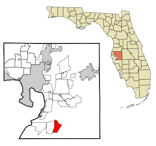
Manatee County is a county in the U.S. state of Florida. As of the 2020 US Census, the population was 399,710. Manatee County is part of the North Port-Bradenton-Sarasota, Florida Metropolitan Statistical Area. Its county seat and largest city is Bradenton. The county was created in 1855 and named for the Florida manatee, Florida's official marine mammal. Features of Manatee County include access to the southern part of the Tampa Bay estuary, the Sunshine Skyway Bridge, and the Manatee River.

<span class="mw-page-title-main">Manasota Key, Florida</span> Census-designated place in Florida, United States

Manasota Key is a census-designated place (CDP) consisting mainly of the community of Englewood Beach in Charlotte County, Florida, United States. The population of the CDP was 1,326 at the 2020 census, up from 1,229 at the 2010 census. It is part of the Punta Gorda, Florida Metropolitan Statistical Area, included in the North Port-Bradenton, Florida Combined Statistical Area.

<span class="mw-page-title-main">Wimauma, Florida</span> Census-designated place in Florida, United States

Wimauma is an unincorporated census-designated place in Hillsborough County, Florida, United States. The population was 6,373 at the 2010 census, up from 4,246 at the 2000 census.

<span class="mw-page-title-main">Bradenton, Florida</span> City in Florida, United States

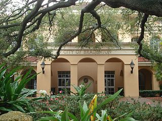
Bradenton is a city in and the county seat of Manatee County, Florida, United States. As of the 2020 census, the city's population is 55,698, up from 49,546 at the 2010 census. It is a principal city in the North Port-Bradenton-Sarasota, Florida Metropolitan Statistical Area. Downtown Bradenton is along the Manatee River and includes the Bradenton Riverwalk. Downtown Bradenton is also home to the Bishop Museum of Science and Nature.

<span class="mw-page-title-main">Bradenton Beach, Florida</span> City in Florida, United States

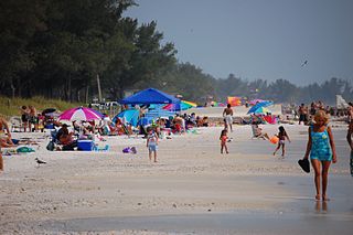
Bradenton Beach is a city on Anna Maria Island in Manatee County, Florida, United States. The population was 908 at the 2020 census, down from 1,171 in 2010. It is part of the North Port-Bradenton-Sarasota, Florida Metropolitan Statistical Area.

<span class="mw-page-title-main">Cortez, Florida</span> Census-designated place in Florida, United States

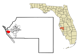
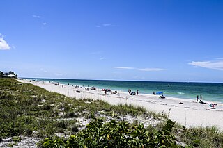
Cortez, a census-designated place (CDP) in Manatee County, Florida, United States, is a small Gulf Coast commercial fishing village that was founded by settlers from North Carolina in the 1880s. The population was 4,121 at the 2020 census, down from 4,241 at the 2010 census. It is part of the North Port-Bradenton-Sarasota, Florida Metropolitan Statistical Area.

<span class="mw-page-title-main">Memphis, Florida</span> Census-designated place in Florida, United States

Memphis is an unincorporated community and census-designated place (CDP) in Manatee County, Florida, United States. The population was 9,024 as of the 2020 census, up from 7,848 in 2010. It is part of the North Port–Bradenton–Sarasota, Florida Metropolitan Statistical Area.

<span class="mw-page-title-main">Samoset, Florida</span> Census-designated place in Florida, United States

Samoset is an unincorporated community and census-designated place (CDP) in Manatee County, Florida, United States. The population was 4,146 at the 2020 census, up from 3,854 in 2010. It is part of the North Port–Bradenton–Sarasota, Florida Metropolitan Statistical Area.

<span class="mw-page-title-main">South Bradenton, Florida</span> Census-designated place in Florida, United States

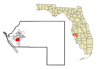
South Bradenton is an unincorporated community and census-designated place (CDP) in Manatee County, Florida, United States. The population was 26,858 at the 2020 census, up from 22,178 in 2010. It is part of the North Port–Bradenton–Sarasota, Florida Metropolitan Statistical Area.

<span class="mw-page-title-main">West Bradenton, Florida</span> Census-designated place in Florida, United States

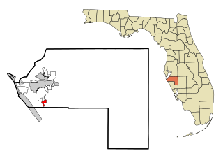
West Bradenton is an unincorporated area and census-designated place (CDP) in Manatee County, Florida, United States. The population was 4,247 at the 2020 census, up from 4,192 at the 2010 census. It is part of the North Port–Bradenton–Sarasota, Florida Metropolitan Statistical Area.

<span class="mw-page-title-main">West Samoset, Florida</span> Census-designated place in Florida, United States

West Samoset is an unincorporated area and census-designated place (CDP) in Manatee County, Florida, United States. The population was 6,482 at the 2020 census, up from 5,583 in 2010. It is part of the North Port–Bradenton–Sarasota, Florida Metropolitan Statistical Area.

<span class="mw-page-title-main">Whitfield, Manatee County, Florida</span> Census-designated place in Florida, United States

Whitfield, also known as Whitfield Estates, is an unincorporated community and census-designated place (CDP) in Manatee County, Florida, United States. As of the 2020 census it had a population of 2,989, up from 2,882 at the 2010 census. It is part of the North Port–Bradenton–Sarasota, Florida Metropolitan Statistical Area. It receives its mail from the Sarasota post office located in Sarasota County.

<span class="mw-page-title-main">Carol City, Florida</span> Neighborhood of Miami Gardens in Miami-Dade, Florida, United States

Carol City is a neighborhood in Miami Gardens, Florida, United States. The population was 61,233 at the 2010 census. It was formerly a census-designated place.

<span class="mw-page-title-main">Southgate, Florida</span> Census-designated place in Florida, United States

Southgate is a census-designated place (CDP) in Sarasota County, Florida, United States. The population was 6,287 at the 2020 census, down from 7,173 at the 2010 census. It is part of the North Port–Bradenton–Sarasota, Florida Metropolitan Statistical Area.

<span class="mw-page-title-main">Vamo, Florida</span> Census-designated place in Florida, United States

Vamo is a census-designated place (CDP) in Sarasota County, Florida, United States. The population was 2,822 at the 2020 census, down from 4,727 at the 2010 census. It is part of the North Port–Bradenton–Sarasota, Florida Metropolitan Statistical Area.

<span class="mw-page-title-main">Venice Gardens, Florida</span> Census-designated place in Florida, United States

Venice Gardens is a census-designated place (CDP) in Sarasota County, Florida, United States. The population was 3,402 at the 2020 census, down from 7,104 at the 2010 census. It is part of the North Port–Bradenton–Sarasota, Florida Metropolitan Statistical Area.

<span class="mw-page-title-main">State College of Florida, Manatee–Sarasota</span> Public college in Manatee and Sarasota County, Florida, United States

State College of Florida, Manatee–Sarasota (SCF) is a public college with campuses in the Manatee and Sarasota counties of Florida. Part of the Florida College System, it is designated a "state college" because it offers a greater number of bachelor's degrees than community colleges. SCF is accredited by the Southern Association of Colleges and Schools. Founded in 1957 as Manatee Junior College, it was known as Manatee Community College from 1985 to 2009.

<span class="mw-page-title-main">Sarasota metropolitan area</span> Metropolitan area in Florida, United States

The Sarasota metropolitan area is a metropolitan area located in Southwest Florida. The metropolitan area is defined by the Office of Management and Budget (OMB) as the North Port–Bradenton–Sarasota Metropolitan Statistical Area, a metropolitan statistical area (MSA) consisting of Manatee County and Sarasota County. The principal cities listed by the OMB for the MSA are North Port, Bradenton, Sarasota, Lakewood Ranch, and Venice. At the 2020 census, the MSA had a population of 833,716. The Census Bureau estimates that its population was 891,411 in 2022.

Lakewood Ranch is a planned community and census-designated place (CDP) in southeastern Manatee County and northeastern Sarasota County, Florida, United States, consisting of approximately 31,000 acres (13,000 ha). It is part of the North Port-Bradenton-Sarasota, Florida Metropolitan Statistical Area. According to the 2020 census, the CDP had a population of 34,877.

State College of Florida Collegiate School (SCFCS) is a public charter school in Florida, United States. Established in 2010, it is part of and operates on State College of Florida's Bradenton and Venice campuses. It was created through a charter with the School District of Manatee County.

References

  1. "US Gazetteer files: 2010, 2000, and 1990". United States Census Bureau. February 12, 2011. Retrieved April 23, 2011.
  2. 1 2 "2022 U.S. Gazetteer Files: Florida". United States Census Bureau. Retrieved December 15, 2022.
  3. 1 2 "P1. Race – Bayshore Gardens CDP, Florida: 2020 DEC Redistricting Data (PL 94-171)". U.S. Census Bureau. Retrieved December 15, 2022.
  4. 1 2 "U.S. Census website". United States Census Bureau . Retrieved January 31, 2008.
  5. "US Board on Geographic Names". United States Geological Survey. October 25, 2007. Retrieved January 31, 2008.
  6. "5 Sep 1955, 153 - Tampa Bay Times at Newspapers.com". Newspapers.com. Retrieved May 19, 2020.
  7. 1 2 3 4 Slusser, Cathy. "Manatee History Matters: Bayshore Gardens, hidden jewel of Mid Century Modern architecture".
  8. "13 Apr 1958, 37 - The Tampa Tribune at Newspapers.com". Newspapers.com. Retrieved May 18, 2020.
  9. "Bayshore Banner, July 2014" (PDF).
  10. "14 Oct 1960, 11 - Tampa Bay Times at Newspapers.com". Newspapers.com. Retrieved May 18, 2020.
  11. "Bayshore Gardens may become part of architectural history".
  12. "Census of Population and Housing". Census.gov. Retrieved June 4, 2016.
  13. 1 2 "Locations". State College of Florida, Manatee–Sarasota. Retrieved July 9, 2019. SCF Bradenton 5840 26th St. W., Bradenton, FL 34207 - Campus map here, which indicates the exact location of SCFCS.
  14. "2010 CENSUS - CENSUS BLOCK MAP: Bayshore Gardens CDP, FL" (PDF). U.S. Census Bureau . Retrieved July 9, 2019.