Province of New Hampshire

Last updated

Province of New Hampshire
1629–1641
1679–1686
1689–1776
Seal of the Province of New Hampshire.png
Seal of the Province of New Hampshire, 1692
Anthem:  God Save the King (1745–1783)
Nhcolony.png
Map of the province
StatusColony of England (1629–1641, 1679–1686, 1689–1707)
Colony of Great Britain (1707–1776)
Capital Portsmouth (de facto 1630-1774; de jure 1679–1775)
Exeter (de facto 1774–1776)
Common languages English (sole language of government)
Abenaki
Various other indigenous languages
Government Land grant colony
(1629-1641)
Self-governing colony
(1679-1686)
(1689-1776)
President  
 1679–1681
John Cutt
 1681–1767
(list)
 1767–1775
John Wentworth
Legislature General Court of New Hampshire
 Upper house
Executive Council
 Lower house
House of Representatives
History 
 Established
1629
 First royal charter issued, governance from 1680
1679
1686–1689
 Second royal charter issued, governance from 1692
1691
 Disestablished
1776
Currency New Hampshire pound (Often pegged to the Pound sterling); Spanish dollar; Pound sterling
Preceded by
Succeeded by
English Red Ensign 1620.svg Province of Maine
English Red Ensign 1620.svg Massachusetts Bay Colony
Flag of New England under Sir Edmund Andros.svg Dominion of New England
Massachusetts Bay Colony New England blank flag.svg
Dominion of New England Flag of New England under Sir Edmund Andros.svg
New Hampshire Flag of the United States (1776-1777).svg
Today part of United States
Topographical map of the province A topographical map of the Province of New Hampshire, LOC 74692582.jpg
Topographical map of the province

The Province of New Hampshire was a colony of England and later a British province in New England. The name was first given in 1629 to the territory between the Merrimack and Piscataqua rivers on the eastern coast of North America, and was named after the county of Hampshire in southern England by Captain John Mason, its first named proprietor. In 1776 the province established an independent state and government, the State of New Hampshire, and joined with twelve other colonies to form the United States.

Contents

Europeans first settled New Hampshire in the 1620s, and the province consisted for many years of a small number of communities along the seacoast, Piscataqua River, and Great Bay. In 1641 the communities were organized under the government of the Massachusetts Bay Colony, until Charles II issued a colonial charter for the province and appointed John Cutt as President of New Hampshire in 1679. After a brief period as a separate province, the territory was absorbed into the Dominion of New England in 1686. Following the collapse of the unpopular Dominion, on October 7, 1691 New Hampshire was again separated from Massachusetts and organized as an English crown colony. Its charter was enacted on May 14, 1692, during the coregency of William and Mary, the joint monarchs of England, Scotland, and Ireland. Between 1699 and 1741, the province's governor was often concurrently the governor of the Province of Massachusetts Bay. This practice ended completely in 1741, when Benning Wentworth was appointed governor. Wentworth laid claim on behalf of the province to lands west of the Connecticut River, east of the Hudson River, and north of Massachusetts, issuing controversial land grants that were disputed by the Province of New York, which also claimed the territory. These disputes resulted in the eventual formation of the Vermont Republic and the U.S. state of Vermont.

The province's economy was dominated by timber and fishing. The timber trade, although lucrative, was a subject of conflict with the crown, which sought to reserve the best trees for use as ship masts. Although the Puritan leaders of Massachusetts ruled the province for many years, the New Hampshire population was more religiously diverse, originating in part in its early years with refugees from opposition to religious differences in Massachusetts.

From the 1680s until 1760, New Hampshire was often on the front lines of military conflicts with New France and the Abenaki people, seeing major attacks on its communities in King William's War, Dummer's War, and King George's War. The province was at first not strongly in favor of independence, but with the outbreak of armed conflict at Lexington and Concord many of its inhabitants joined the revolutionary cause. After Governor John Wentworth fled New Hampshire in August 1775, the inhabitants adopted a constitution in early 1776. Independence as part of the United States was confirmed with the 1783 Treaty of Paris.

Before colonization

Prior to English colonization, the area that is now northeastern New England was populated by bands of the Abenaki, who lived in sometimes-large villages of longhouses. [1] Depending on the season, they would either remain near their villages to fish, gather plants, engage in sugaring, and trade or fight with their neighbors, or head to nearby fowling and hunting grounds; later they also farmed tobacco and the "three sisters": corn, beans, and squash. [1] The seacoast was explored in the early years of the 17th century by English and French explorers, including Samuel de Champlain and John Smith. [2]

Early English settlement

Permanent English settlement began after land grants were issued in 1622 to John Mason and Sir Ferdinando Gorges for the territory between the Merrimack and Sagadahoc (Kennebec) rivers, roughly encompassing present-day New Hampshire and western Maine. Settlers, whose early leaders included David Thomson, Edward Hilton and his brother William Hilton, began settling the New Hampshire coast as early as 1623, and eventually expanded along the shores of the Piscataqua River and the Great Bay. These settlers were mostly intending to profit from the local fisheries. Mason and Gorges, neither of whom ever came to New England, divided their claims along the Piscataqua River in 1629. [3] Mason took the territory between the Piscataqua and Merrimack, and called it "New Hampshire", after the English county of Hampshire. [4]

Conflicts between holders of grants issued by Mason and Gorges concerning their boundaries eventually led to a need for more active management. In 1630, Captain Walter Neale was sent as chief agent and governor of the lower settlements on the Piscataqua (including Strawbery Banke, present-day Portsmouth), and in 1631 Captain Thomas Wiggin was sent to govern the upper settlements, comprising modern-day Dover, Durham and Stratham. [5] After Mason died in 1635, the colonists and employees of Mason appropriated many of his holdings to themselves. [6] Exeter was founded in 1638 by John Wheelwright, after he had been banished from the neighboring Massachusetts Bay Colony for defending the teachings of Anne Hutchinson, his sister-in-law. In the absence of granting authority from anyone associated with the Masons, Wheelwright's party purchased the land from local Indians. His party included William Wentworth, whose descendants came to play a major role in colonial history. [7] Around the same time, others unhappy with the strict Puritan rule in Massachusetts settled in Dover, while Puritans from Massachusetts settled what eventually became Hampton. [8]

Because of a general lack of government, the New Hampshire settlements sought the protection of their larger neighbor to the south, the Massachusetts Bay Colony. In 1641, they collectively agreed to be governed from Massachusetts, provided the towns retained self-rule, and that Congregational Church membership was not required for their voters (as it was in Massachusetts). The settlements formed part of that colony until 1679, sending representatives to the Massachusetts legislature in Boston. Mason's heirs were in the meantime active in England, seeking to regain control of their territory, and Massachusetts was coming under increasing scrutiny by King Charles II. In 1679, Charles issued a charter establishing the Province of New Hampshire, with John Cutt as its first president.

First royal charters

In January 1680, Cutt took office, ending Massachusetts governance. However, Cutt and his successor, Richard Waldron, were strongly opposed to the Mason heirs and their claims. Consequently, Charles issued a second charter in 1682 with Edward Cranfield as governor. Cranfield strongly supported the Mason heirs, making so many local enemies in the process that he was recalled in 1685. In 1686, the territory was brought into the Dominion of New England, an attempt to unify all of the New England colonies into a single government. The New Hampshire towns did not suffer as much under the rule of Sir Edmund Andros as did Massachusetts. After word of the Glorious Revolution reached Boston, Massachusetts authorities conspired to have Andros arrested and sent back to England. This left the New Hampshire towns without any colonial administration, just as King William's War erupted around them. Subjected to significant French and Indian raids, they appealed to Massachusetts Governor Simon Bradstreet, who oversaw them until William III and Mary II issued new, separate charters in 1691 for both Massachusetts and New Hampshire.

1691 charter

Samuel Allen, a businessman who had acquired the Mason claims, was appointed the first governor under the 1691 charter. He was equally unsuccessful in pursuing the Mason land claims, and was replaced in 1699 by the Earl of Bellomont. Bellomont was the first in a series of governors who ruled both New Hampshire and the Province of Massachusetts Bay. Until 1741 the governorships were shared, with the governor spending most of his time in Massachusetts. As a result, the lieutenant governors held significant power. The dual governorship became problematic in part because of territorial claims between Massachusetts and New Hampshire. Since the southern border of the original Mason grant was the Merrimack River, and the Massachusetts charter specified a boundary three miles north of the same river, the claims conflicted, and were eventually brought to the king's attention. In 1741, King George II decreed what is now the border between Massachusetts and New Hampshire, and separated the governorships, issuing a commission to Benning Wentworth as New Hampshire governor.

Wentworth broadly interpreted New Hampshire's territorial claims, believing that territories west of the Connecticut River belonged to New Hampshire. In a scheme that was effective at lining his own pockets, he sold land grants in this territory for relatively low prices, but required parts of the grants to be allocated to himself. These grants brought New Hampshire into conflict with the Province of New York, the other claimant to the territory. King George III in 1764 ruled in New York's favor, setting off a struggle between the holders of the New Hampshire Grants and New York authorities that eventually resulted in the formation of the state of Vermont. The controversy also resulted in the replacement of Wentworth by his nephew John, who would be the last royal governor of the province.

Since the province was on the northern frontier bordering New France, its communities were frequently attacked during King William's War and Queen Anne's War, and then again in the 1720s during Dummer's War. Because of these wars the Indian population in the northern parts of the province declined, but settlements only slowly expanded into the province's interior. The province was partitioned into counties in 1769, later than the other twelve colonies that revolted against the British Empire.

American Revolution

Twelve other colonies joined with New Hampshire in resisting attempts by the British Parliament to impose taxes. After the American Revolutionary War began in April 1775, the province recruited regiments that served in the Siege of Boston, and was the first former European colony to formally establish an independent government, as the State of New Hampshire, in January 1776.

Demographics

Historical population
YearPop.±%
1630500    
16401,055+111.0%
16501,305+23.7%
16601,555+19.2%
16701,805+16.1%
16802,047+13.4%
16904,164+103.4%
17004,958+19.1%
17105,681+14.6%
17209,375+65.0%
173010,755+14.7%
174023,256+116.2%
175027,505+18.3%
176039,093+42.1%
177062,396+59.6%
177373,097+17.2%
178087,802+20.1%
Source: 1630–1760; [9] 1773 [10] 1770 & 1780 [11]

From 1630 to 1780, the population of New Hampshire grew from 500 to 87,802. [9] [10] [11] In 1623, the first permanent English settlements, Dover and Rye, were established, [12] [13] [14] while Portsmouth was the largest city by 1773 with a population of 4,372. [10] The black population in the colony grew from 30 in 1640 to 674 in 1773 (ranging between 1 and 4 percent of the population), [9] [10] but declined to 541 (or 0.6 percent of the population) by 1780. [11]

In New Hampshire, unlike some of the other New England Colonies, the Puritan Congregational church was not the established church in the colony. [15] Following the First Great Awakening (1730–1755), the number of regular places of worship in New Hampshire had grown to 46 in 1750 (40 Congregational, five Presbyterian, and one Anglican), [16] and to 125 regular places of worship by 1776 (78 Congregational, 27 Presbyterian, 13 Baptist, four Friends, two Episcopal, and one New Light Congregational). [17]

See also

Notes

  1. 1 2 Native Americans in Vermont: the Abenaki Archived July 14, 2006, at the Wayback Machine , from flowofhistory.org, a website funded by educational grants
  2. Clarke, p. 4
  3. Clark, pp. 17–18
  4. "Fast New Hampshire Facts". State of New Hampshire. Retrieved July 9, 2011.
  5. Clark, p. 18
  6. Clark, pp. 18–20
  7. Clark, pp. 37–39
  8. Clark, pp. 39–42
  9. 1 2 3 Purvis, Thomas L. (1999). Balkin, Richard (ed.). Colonial America to 1763. New York: Facts on File. pp.  128–129. ISBN   978-0816025275.
  10. 1 2 3 4 Purvis, Thomas L. (1995). Balkin, Richard (ed.). Revolutionary America 1763 to 1800. New York: Facts on File. p.  127. ISBN   978-0816025282.
  11. 1 2 3 "Colonial and Pre-Federal Statistics" (PDF). United States Census Bureau. p. 1168.
  12. Purvis, Thomas L. (1999). Balkin, Richard (ed.). Colonial America to 1763. New York: Facts on File. pp.  205–206. ISBN   978-0816025275.
  13. Purvis, Thomas L. (1995). Balkin, Richard (ed.). Revolutionary America 1763 to 1800. New York: Facts on File. p.  247. ISBN   978-0816025282.
  14. Stackpole, Everett Schermerhorn (1916). History of New Hampshire. New York: The American Historical Society. ISBN   978-1-115-84294-5.
  15. Purvis, Thomas L. (1999). Balkin, Richard (ed.). Colonial America to 1763. New York: Facts on File. pp.  178–180. ISBN   978-0816025275.
  16. Purvis, Thomas L. (1999). Balkin, Richard (ed.). Colonial America to 1763. New York: Facts on File. pp.  181. ISBN   978-0816025275.
  17. Purvis, Thomas L. (1995). Balkin, Richard (ed.). Revolutionary America 1763 to 1800. New York: Facts on File. p.  198. ISBN   978-0816025282.

Related Research Articles

<span class="mw-page-title-main">York County, Maine</span> County in Maine, United States

York County is the southwesternmost county in the U.S. state of Maine, along the state of New Hampshire's eastern border. It is divided from Strafford County, New Hampshire, by the Salmon Falls River and the connected tidal estuary, the Piscataqua River. York County was permanently established in 1639. Several of Maine's earliest colonial settlements are found in the county, which is the state's oldest and one of the oldest in the United States. As of the 2020 census, its population was 211,972, making it Maine's second-most populous county. Its county seat is Alfred. York County is part of the Portland–South Portland, Maine Metropolitan Statistical Area.

<span class="mw-page-title-main">Massachusetts Bay Colony</span> 1630–1691 English colony in North America

The Massachusetts Bay Colony (1628–1691), more formally the Colony of Massachusetts Bay, was an English settlement on the east coast of North America around the Massachusetts Bay, one of the several colonies later reorganized as the Province of Massachusetts Bay. The lands of the settlement were in southern New England, with initial settlements on two natural harbors and surrounding land about 15.4 miles (24.8 km) apart—the areas around Salem and Boston, north of the previously established Plymouth Colony. The territory nominally administered by the Massachusetts Bay Colony covered much of central New England, including portions of Massachusetts, Maine, New Hampshire, and Connecticut.

<span class="mw-page-title-main">Benning Wentworth</span> American merchant and colonial administrator (1696–1770)

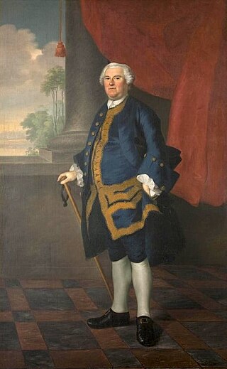
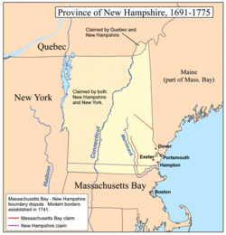
Benning Wentworth was an American merchant and colonial administrator who served as the governor of New Hampshire from 1741 to 1766. While serving as governor, Wentworth is best known for issuing several land grants in territory claimed by the Province of New Hampshire west of the Connecticut River, which led to disputes with the neighboring colony of New York and the eventual founding of Vermont.

<span class="mw-page-title-main">Connecticut Colony</span> British colony in North America (1636–1776)

The Connecticut Colony or Colony of Connecticut, originally known as the Connecticut River Colony or simply the River Colony, was an English colony in New England which later became Connecticut. It was organized on March 3, 1636 as a settlement for a Puritan congregation, and the English permanently gained control of the region in 1637 after struggles with the Dutch. The colony was later the scene of a bloody war between the colonists and Pequot Indians known as the Pequot War. Connecticut Colony played a significant role in the establishment of self-government in the New World with its refusal to surrender local authority to the Dominion of New England, an event known as the Charter Oak incident which occurred at Jeremy Adams' inn and tavern.

<span class="mw-page-title-main">Province of New Jersey</span> British colony in North America (1664–1673, 1702–1776)

The Province of New Jersey was one of the Middle Colonies of Colonial America and became the U.S. state of New Jersey in 1776. The province had originally been settled by Europeans as part of New Netherland but came under English rule after the surrender of Fort Amsterdam in 1664, becoming a proprietary colony. The English renamed the province after the island of Jersey in the English Channel. The Dutch Republic reasserted control for a brief period in 1673–1674. After that it consisted of two political divisions, East Jersey and West Jersey, until they were united as a royal colony in 1702. The original boundaries of the province were slightly larger than the current state, extending into a part of the present state of New York, until the border was finalized in 1773.

<span class="mw-page-title-main">Delaware Colony</span> British colony in North America (1664–1776)

Delaware Colony in the North American Middle Colonies consisted of land on the west bank of the Delaware River Bay. In the early 17th century, the area was inhabited by Lenape and possibly Assateague Native American Indian tribes. The first European settlers were Swedes, who established the colony of New Sweden at Fort Christina in present-day Wilmington, Delaware, in 1638. The Dutch captured the colony in 1655 and annexed it to New Netherland to the north. Great Britain subsequently took control of it from the Dutch in 1664. In 1682, William Penn, the Quaker proprietor of the Province of Pennsylvania to the north leased the three lower counties on the Delaware River from James, the Duke of York, who went on to become King James II.

<span class="mw-page-title-main">Colony of Rhode Island and Providence Plantations</span> British colony in North America (1636–1776)

The Colony of Rhode Island and Providence Plantations was one of the original Thirteen Colonies established on the east coast of America, bordering the Atlantic Ocean. It was founded by Roger Williams. It was an English colony from 1636 until 1707, and then a colony of Great Britain until the American Revolution in 1776, when it became the State of Rhode Island and Providence Plantations.

<span class="mw-page-title-main">New Hampshire Grants</span> Land grants in colonial New Hampshire (1749-64); later became the Republic of Vermont

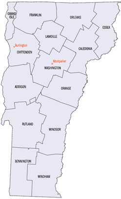
The New Hampshire Grants or Benning Wentworth Grants were land grants made between 1749 and 1764 by the colonial governor of the Province of New Hampshire, Benning Wentworth. The land grants, totaling about 135, were made on land claimed by New Hampshire west of the Connecticut River, territory that was also claimed by the Province of New York. The resulting dispute led to the eventual establishment of the Vermont Republic, which later became the U.S. state of Vermont.

<span class="mw-page-title-main">Province of South Carolina</span> British province in North America (1712–1776)

The Province of South Carolina, originally known as Clarendon Province, was a province of the Kingdom of Great Britain that existed in North America from 1712 to 1776. It was one of the five Southern colonies and one of the thirteen American colonies of the British Empire. The monarch of Great Britain was represented by the Governor of South Carolina, until the colonies declared independence on July 4, 1776.

<span class="mw-page-title-main">Province of Carolina</span> English (later British) colony in North America and the Caribbean (1663–1712)

The Province of Carolina was a province of the Kingdom of England (1663–1707) and later the Kingdom of Great Britain (1707–1712) that existed in North America and the Caribbean from 1663 until partitioned into North and South on January 24, 1712. It consisted of all or parts of present-day Alabama, Florida, Georgia, Mississippi, North Carolina, South Carolina, Tennessee, and the Bahamas.

<span class="mw-page-title-main">Province of Maine</span> 17th century English colonies in North America

The Province of Maine refers to any of the various English colonies established in the 17th century along the northeast coast of North America, within portions of the present-day U.S. states of Maine, New Hampshire, and Vermont, and the Canadian provinces of Quebec and New Brunswick. It existed through a series of land patents made by the kings of England during this era, and included New Somersetshire, Lygonia, and Falmouth. The province was incorporated into the Massachusetts Bay Colony during the 1650s, beginning with the formation of York County, Massachusetts, which extended from the Piscataqua River to just east of the mouth of the Presumpscot River in Casco Bay. Eventually, its territory grew to encompass nearly all of present-day Maine.

<span class="mw-page-title-main">Province of Massachusetts Bay</span> British colony in North America from 1691 to 1776

The Province of Massachusetts Bay was a colony in New England which became one of the thirteen original states of the United States. It was chartered on October 7, 1691, by William III and Mary II, the joint monarchs of the kingdoms of England, Scotland, and Ireland, and was based in the merging of several earlier British colonies in New England. The charter took effect on May 14, 1692, and included the Massachusetts Bay Colony, the Plymouth Colony, the Province of Maine, Martha's Vineyard, Nantucket, Nova Scotia, and New Brunswick; the Commonwealth of Massachusetts is the direct successor. Maine has been a separate state since 1820, and Nova Scotia and New Brunswick are now Canadian provinces, having been part of the colony only until 1697.

<span class="mw-page-title-main">John Mason (governor)</span> Canadian politician

Captain John Mason (1586–1635) was an English sailor and colonist who was instrumental to the establishment of various settlements in colonial America. Born in 1586 at King's Lynn, Norfolk, and educated at Peterhouse, Cambridge. In 1610, he was appointed by James I to help reclaim the Hebrides. As a reward, he was granted exclusive fishing rights in the North Sea. This was ignored by the Dutch and he was treated as a pirate by the Scots. In 1615, he was arrested, but soon released after the seizure of his ship. He was appointed the second Proprietary Governor of Newfoundland's Cuper's Cove colony in 1615, succeeding John Guy. Mason arrived on the island in 1616 and explored much of the territory. He compiled a map of the island and wrote and published a short tract of his findings.

<span class="mw-page-title-main">Joseph Dudley</span> Royal governor of Massachusetts

Joseph Dudley was a colonial administrator, a native of Roxbury in Massachusetts Bay Colony, and the son of one of its founders. He had a leading role in the administration of the Dominion of New England (1686–1689), which was overthrown in the 1689 Boston revolt. He served briefly on the council of the Province of New York, from which he oversaw the trial which convicted Jacob Leisler, the ringleader of Leisler's Rebellion. He then spent eight years in England in the 1690s as Lieutenant-Governor of the Isle of Wight, including one year as a Member of Parliament for Newtown. In 1702, he returned to New England after being appointed governor of the Province of Massachusetts Bay and Province of New Hampshire, posts that he held until 1715.

The District of Maine was the governmental designation for what is now the U.S. state of Maine from October 25, 1780 to March 15, 1820, when it was admitted to the Union as the 23rd state. The district was a part of the Commonwealth of Massachusetts and before American independence had been part of the British province of Massachusetts Bay.

New Hampshire is a state in the New England region of the northeastern United States. During the American Revolution, it was one of the Thirteen Colonies that revolted against British rule. One of the smallest U.S. states in area and population, it was part of New England's textile economy between the American Civil War and World War II. Since the 20th century, the state has been known for its presidential primary, outdoor recreation, its educational boarding schools, and being part of the biotech industry.

<span class="mw-page-title-main">Henry Josselyn</span>

Henry Josselyn was an early settler of northern New England. He was first retained by John Mason, the proprietor of the territory that later became New Hampshire, to administer his holdings. Arriving at the Piscataqua River in 1634, he administered Mason's settlement until Mason's death in 1635.. He thereafter moved further up the coast, settling in what is now Scarborough, Maine. He briefly acted as deputy governor of the Province of Maine in the colonial administration of Thomas Gorges, before the area came under the control of the Massachusetts Bay Colony. He was opposed to Massachusetts rule, and was arrested on one occasion for his resistance. When the area was granted to James, Duke of York in 1664, it became part of the Province of New York, and Josselyn was appointed a magistrate.

References