Basutoland

Last updated

Colony of Basutoland
1884–1966
Royal anthem:  God Save the Queen (1884–1901; 1952–1966)
God Save the King (1901–1952)
LocationLesotho.svg
Status Crown Colony under partial local rule
Capital Maseru
Languages
Government Constitutional monarchy
Resident Commissioner(a.k.a governor) 
 1884–1894
Marshal Clarke
 1961–1966
Alexander Giles
Paramount Chief  
 1884–1891
Letsie I
 1891–1905
Lerotholi Letsie I
 1905–1913
Letsie II
 1913–1939
Nathaniel Griffith Lerotholi
 1939–1960
Simon Seeiso Griffith
 1960–1966
Moshoeshoe II
History 
 Established
18 March 1884
 Disestablished
4 October 1966
Area
 Total
30,355 km2 (11,720 sq mi)
Population
 1875
128,206
 1904
348,848 [1]
Currency
Preceded by
Succeeded by
Flag of the Cape Colony (1876-1910).svg Cape Colony
Lesotho Flag of Lesotho (1966-1987).svg
Today part of Lesotho

Basutoland was a British Crown colony that existed from 1884 to 1966 in present-day Lesotho, bordered with the Cape Colony, Natal Colony and Orange River Colony until 1910 and completely surrounded by South Africa from 1910. Though the Basotho (then known as Basuto) and their territory had been under British control starting in 1868 (and ruled by Cape Colony from 1871), the Cape Colony was unpopular and unable to control the territory. As a result, Basutoland was brought under direct authority of Queen Victoria, via the High Commissioner, and run by an Executive Council presided over by a series of British Resident Commissioners.

Contents

It was divided into seven administrative districts: Berea, Leribe, Maseru, Mohale's Hoek, Mafeteng, Qacha's Nek and Quthing.

Basutoland gained its independence from the United Kingdom on 4 October 1966 and was renamed the Kingdom of Lesotho.

History

Background

Between 1856 and 1868 the Basotho engaged in conflict with the Orange Free State. [2] Their king, Moshoeshoe I, sought British protection. [2] On 29 August 1865, he wrote to Sir Philip Wodehouse, the Governor of Cape Colony: [2]

I am giving myself and my country up to Her Majesty's Government under certain conditions which we may agree on between your Excellency and me.

In July 1866, after referring to the former letter, the Chief said: [2]

All those things I have given up into your hands the last year..., they are still yours. I still continue to be the humble servant of Her Majesty.

Eventually, in January 1868, the Governor received a document dated 9 December 1867, signed by the Secretary of State for the Colonies, authorizing the annexation of Basutoland to the Colony of Natal (not to the Cape as Wodehouse had wished). [2] On 12 March 1868, a proclamation declared the Basotho to be British subjects and Basutoland to be British territory. [3] It was not in fact annexed to Natal, as Natal attempted unsuccessfully to condition its acceptance on Basotho land being made available for European settlement; so for some time Basutoland remained under the direct authority of Wodehouse as British High Commissioner for South Africa. [2]

Postage stamp with a portrait of Queen Elizabeth II, 1963 1963 Basutoland R1 mohair.jpg
Postage stamp with a portrait of Queen Elizabeth II, 1963

Three years later, Basutoland was annexed to the Cape Colony by Act No. 12 of 1871 of the Parliament of the Cape of Good Hope, confirmed by an Order in Council of 3 November 1871. [2] The rule of the Cape Colony then proved unpopular with the people, leading to the Basuto Gun War of 1880–1881.

By an Order in Council dated 2 February 1884, which came into force on 18 March 1884, [4] royal assent was given to a Cape bill repealing the Act of 1871. Basutoland was thus brought under the direct authority of the Queen, with legislative and executive powers again vested in the High Commissioner. [2]

As a crown colony

Moshoeshoe had been succeeded as paramount chief by his son, Letsie I, and he in turn was succeeded in 1891 by Lerotholi Letsie I. These chieftains acted in concert with the British representative in the country, to whom was given the title of resident commissioner. The first commissioner was Sir Marshal James Clarke. The period of warfare over, the Basotho turned their attention more and more to agricultural pursuits and Christian missionaries entered the territory. Trade increased, and in 1891 Basutoland was admitted to the customs union, which already existed between Orange Free State, Cape Colony and British Bechuanaland. When Alfred Milner visited Basutoland in 1898, on his way to Bloemfontein, he was received by 15,000 mounted Basotho. The chiefs also attended a large meeting at Maseru. On the outbreak of the Boer War in 1899, these same chiefs proclaimed loyalty to the British Crown. They remained passive throughout the War and the neutrality of the country was respected by both armies. One chief alone sought to take advantage of the situation by disloyal action, and his offence was met by a year's imprisonment. [5]

In pursuance of the policy of encouraging the self-governing powers of the Basotho, a national council was instituted and held its first sitting in July 1903. In August 1905 the paramount chief Lerotholi died. In early life he had distinguished himself in the wars with the Boers, and in 1880 he took an active part in the revolt against the Cape government. Since 1884 he had been a loyal supporter of the imperial authorities, and carried a reputation for high diplomatic gifts. On the 19th of September following Lerotholi's death, the national council, with the concurrence of the imperial government, elected his son Letsie II as paramount chief. The completion in October 1905 of a railway connecting Maseru with the South African railway system proved a great boon to the community. During the Bambatha Rebellion in 1906 the Basotho remained perfectly quiet. [5]

Government

Executive branch

Basutoland's Executive Council members were the resident commissioner, who presided, three ex-officio members and four council members from the Basutoland National Council, appointed by the resident commissioner, one by the Paramount Chief and three nominated by the Council itself, selected by secret ballot.

Legislative branch

The legislative council, known as the Basutoland National Council, consisted of a non-voting President appointed by the Resident Commissioner, four official members (ex officio), twenty-two Chiefs, forty elected members elected by District Councils, and fourteen nominated members appointed by the Resident Commissioner on the nomination of the Paramount Chief. The Resident Commissioner had the right to address the council.

The Commissioner had authority to make laws by Proclamation on certain subjects, such as external affairs, defence and the public service. These matters were excluded from the powers of the National Council, but the Commissioner was required to lay a draft of any Proclamation before the council and to consider their observations. The Constitution made special provision regarding particular objections made by the council.

Paramount Chief

There was a College of Chiefs of Basutoland whose function related to matters pertaining to the offices of the Paramount Chief, Chief and Headman. Their decisions and recommendations were submitted for acceptance to the Paramount Chief. They were subject to review by the High Court.

The Constitution vested a number of functions in the Paramount Chief. In exercising these, he was required in most cases to consult either with the Executive Council or with the Resident Commissioner, a Council member of the Executive and a member of the Basotho Nation appointed by himself.

Land in Basutoland was vested by the Constitution in the Paramount Chief in trust for the Basotho Nation, subject to lawfully acquired rights.

Demographics

Considering the extensive area of uninhabitable mountain land it contained, the territory supported a mediocre population. The inhabitants increased from 128,206 in 1875, to 348,848 in 1904. Women outnumbered men by about 20,000, which was, however, about the number of adult men away from the country at any given period. The majority lived in the district between the Maloti Mountains and the Caledon River. The great bulk of the people were Basotho, but there were some thousands of Barolong and other natives. The White inhabitants in 1904 numbered 895. Maseru, the seat of government, had in 1904 a population of about 1,000 including some 100 Europeans. [5]

Districts

British Resident Commissioners

IncumbentTenureNotes
Took officeLeft office
Sir Marshal James Clarke 18 March 188418 September 1894Afterwards Resident Commissioner in Zululand, 1894
Godfrey Yeatman Lagden 18 September 18941895
Sir Herbert Cecil Sloley 1895
Godfrey Yeatman Lagden 18951901
Sir Herbert Cecil Sloley 19021903
James MacGregor1913
Sir Herbert Cecil Sloley 19131916
Robert Thorne Coryndon 19161917Afterwards Governor of Uganda, 1918
Sir Edward Charles Frederick Garraway 1917Apr 1926
John Christian Ramsay Sturrock Apr 1926Mar 1935
Sir Edmund Charles Smith Richards Mar 1935Aug 1942Afterwards Governor of Nyasaland, 1942
Sir Charles Noble Arden-Clarke Aug 1942Nov 1946Afterwards Governor of Sarawak, 1946
Aubrey Denzil Forsyth-Thompson Nov 194624 October 1951
Edwin Porter Arrowsmith 24 October 1951Sep 1956
Alan Geoffrey Tunstal Chaplin Sep 19561961
Alexander Falconer Giles 196130 April 1965

Chief Justices

The Chief Justice was the Chief Justice of the High Commission Territories (Basutoland, Bechuanaland Protectorate and Swaziland). [6] From 1951 the Chief Justices were:

IncumbentTenureNotes
Took officeLeft office
Walter Harragin19511952
Harold Curwen Willan19521956
Herbert Charles Fahie Cox 19571960
Peter Watkin-Williams19611966

Related Research Articles

<span class="mw-page-title-main">Lesotho</span> Country in Southern Africa, within the border of South Africa

Lesotho, formally the Kingdom of Lesotho, is a landlocked country in Southern Africa. As an enclave of South Africa, with which it shares a 1,106 km border, it is the only sovereign enclave in the world outside of the Italian Peninsula. It is situated in the Maloti Mountains and contains the highest peak in Southern Africa. It has an area of over 30,000 km2 (11,600 sq mi) and has a population of about 2 million. Its capital and largest city is Maseru.

<span class="mw-page-title-main">History of Lesotho</span> Historical development of Lesotho

The history of people living in the area now known as Lesotho goes back as many as 400 years. Present Lesotho emerged as a single polity under King Moshoeshoe I in 1822. Under Moshoeshoe I, Basotho joined other clans in their struggle against the Lifaqane associated with famine and the reign of Shaka Zulu from 1818 to 1828.

<span class="mw-page-title-main">Geography of Lesotho</span> Landlocked country in Africa

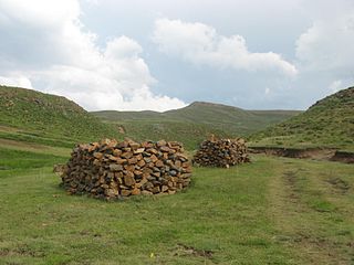
Lesotho is a mountainous, landlocked country located in Southern Africa. It is an enclave, surrounded by South Africa. The total length of the country's borders is 909 kilometres (565 mi). Lesotho covers an area of around 30,355 square kilometres (11,720 sq mi), of which a negligible percentage is covered with water.

<span class="mw-page-title-main">Politics of Lesotho</span>

Politics of Lesotho takes place in a framework of a parliamentary representative democratic constitutional monarchy, whereby the Prime Minister of Lesotho is the head of government, and of a multi-party system. Executive power is exercised by the government. Legislative power is vested in both the government and the two chambers of Parliament, the Senate and the National Assembly. The Judiciary is independent of the executive and the legislature.

<span class="mw-page-title-main">Orange Free State</span> 1854–1902 Boer republic in Southern Africa

The Orange Free State was an independent Boer sovereign republic under British suzerainty in Southern Africa during the second half of the 19th century, which ceased to exist after it was defeated and surrendered to the British Empire at the end of the Second Boer War in 1902. It is one of the three historical precursors to the present-day Free State province.

<span class="mw-page-title-main">Sotho people</span> Bantu ethnic group of Southern Africa

The Sotho, also known as the Basotho, are a prominent Sotho-Tswana ethnic group native to Southern Africa. They primarily inhabit the regions of Lesotho and South Africa.

<span class="mw-page-title-main">Moshoeshoe I</span> First King of Lesotho

Moshoeshoe I was the first king of Lesotho. He was the first son of Mokhachane, a minor chief of the Bamokoteli lineage, a branch of the Koena (crocodile) clan. In his youth, he helped his father gain power over some other smaller clans. At the age of 34 Moshoeshoe formed his own clan and became a chief. He and his followers settled at the Butha-Buthe Mountain. He became the first and longest-serving King of Lesotho in 1822.

<span class="mw-page-title-main">Mohale's Hoek District</span> District in Lesotho

Mohale's Hoek is a district of Lesotho. Mohale's Hoek is the capital city or camptown, and only town in the district. In the southwest, Mohale's Hoek borders on South Africa, while domestically, it borders on Mafeteng District in northwest, Maseru District in north, Thaba-Tseka District in northeast, Qacha's Nek District in east, and Quthing District in southeast.

<span class="mw-page-title-main">Basuto Gun War</span> Conflict between the Basuto and the Cape Colony

The Basuto Gun War, also known as the Basutoland Rebellion, was a conflict between the Basuto and the British Cape Colony. It lasted from 13 September 1880 to 29 April 1881 and ended in a Basuto victory.

<span class="mw-page-title-main">Smithfield, South Africa</span> Place in Free State, South Africa

Smithfield is a small town in the Free State province of South Africa. Founded in 1848 in the Orange River Sovereignty, the town is situated in a rural farming district and is the third oldest town in present-day Free State, after Philippolis and Winburg.

<span class="mw-page-title-main">Free State–Basotho Wars</span> 1858–1868 series of Boer Wars in Southern Africa

The Free State–Basotho Wars refers to a series of wars fought between King Moshoeshoe I, the ruler of the Basotho Kingdom, and white settlers, in what is now known as the Free State. These can be divided into the Senekal's War of 1858, the Seqiti War in 1865−1866 and the Third Basotho War in 1867−68.

Moshoeshoe may refer to:

<span class="mw-page-title-main">Thomas Charles Scanlen</span>

Sir Thomas Charles Scanlen was a politician and administrator of the Cape Colony.

'Mantšebo was the ruler of Basutoland from 1941 to 1960, as the regent for her stepson, the future Moshoeshoe II.

<span class="mw-page-title-main">Subdivisions of Lesotho</span>

Administratively, Lesotho is divided into ten districts, each headed by a district administrator. Each district has a capital known as a camptown.

<span class="mw-page-title-main">Lesotho–South Africa border</span> International border

The border between Lesotho and South Africa is 909 kilometres (565 mi) long and forms a complete loop, as Lesotho is an enclave entirely surrounded by South Africa. The border follows the Caledon River, the drainage divide of the Drakensberg mountains, the Orange River, the Makhaleng River, and a series of hills joining the Makhaleng back to the Caledon.

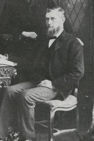
Lieutenant-Colonel Sir Marshal James Clarke was a British colonial administrator and an officer of the Royal Artillery. He was the first Resident Commissioner in Basutoland from 1884 to 1893; Resident Commissioner in Zululand from 1893 to 1898; and, following the botched Jameson Raid, the first Resident Commissioner in Southern Rhodesia from 1898 to 1905.

<span class="mw-page-title-main">Morosi</span>

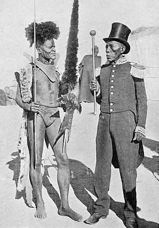
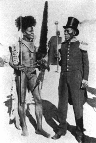
Morosi was a Baphuthi chief in the wild southern part of Basutoland. He led a revolt against the Cape Colony government in 1879, in defence of his independence south of the Orange River. The British refused to help the Cape Government. However, Letsie, the paramount chief and first son of Moshoeshoe, and many of the Sotho ruling establishment, rallied to support the Cape forces, and the rebellion was put down after several months of arduous fighting. Morosi was beheaded and his body mutilated by Cape troops.

<span class="mw-page-title-main">Basotho nationality law</span> Lesotho law governing nationality

Basotho nationality law is regulated by the Constitution of Lesotho, as amended; the Lesotho Citizenship Order, and its revisions; the 1983 Refugees Act; and various international agreements to which the country is a signatory. These laws determine who is, or is eligible to be, a national of Lesotho. The legal means to acquire nationality, formal legal membership in a nation, differ from the domestic relationship of rights and obligations between a national and the nation, known as citizenship. Nationality describes the relationship of an individual to the state under international law, whereas citizenship is the domestic relationship of an individual within the nation. In Britain and thus the Commonwealth of Nations, though the terms are often used synonymously outside of law, they are governed by different statutes and regulated by different authorities. Basotho nationality is typically obtained under the principle of jus soli, born in Lesotho, or jus sanguinis, i.e. by birth in Lesotho or abroad to parents with Basotho nationality. It can be granted to persons with an affiliation to the country, or to a permanent resident who has lived in the country for a given period of time through naturalisation.

<span class="mw-page-title-main">Masopha</span> Lesotho chief

Masopha was a chief of the Basuto people. He was the third son of Basuto paramount chief Moshoeshoe I. During his youth he fought in numerous conflicts against neighboring tribes and European colonists, distinguishing himself for his bravery. Following the incorporation of Basutoland into the Cape Colony, Masopha resisted the imposition of colonial rule and emerged as one of the most powerful Basuto chiefs. In 1880, he became one of the leaders of Basuto resistance to the Cape in the Basuto Gun War. Following the end of the war he came into conflict with his nephew and heir apparent Lerotholi. The two clashed in a brief civil war in January 1898. Masopha was defeated and died in obscurity in July 1898.

References

  1. Census of the British empire. 1901. London: HMSO. 1906. p. 160.
  2. 1 2 3 4 5 6 7 8 Roberts-Wray, Sir Kenneth (1966). Commonwealth and Colonial Law. London: F.A. Praeger. p. 830.
  3. Tylden, G. (1950). The Rise of the Basuto. Juta. p. 107.
  4. S.R.O. & S.I. Rev. III, 79
  5. 1 2 3 Wikisource-logo.svg This article incorporates text from a publication now in the public domain : Cana, Frank Richardson; Hillier, Alfred Peter (1911). "Basutoland". Encyclopædia Britannica . Vol. 3 (11th ed.). pp. 503–506.
  6. "Bechuanaland Colonial Administrators c.1884-c.1965" . Retrieved 27 February 2016.

Wikisource-logo.svg This article incorporates text from a publication now in the public domain : Cana, Frank Richardson; Hillier, Alfred Peter (1911). "Basutoland". Encyclopædia Britannica . Vol. 3 (11th ed.). pp. 503–506.

29°31′00″S27°48′00″E / 29.5167°S 27.8000°E / -29.5167; 27.8000