Greensboro, Florida

Last updated

Greensboro, Florida
Greensboro Town Hall.jpg
Greensboro Town Hall
Gadsden County Florida Incorporated and Unincorporated areas Greensboro Highlighted.svg
Location in Gadsden County and the state of Florida
Coordinates: 30°34′10″N84°44′40″W / 30.56944°N 84.74444°W / 30.56944; -84.74444
Country Flag of the United States.svg  United States
State Flag of Florida.svg  Florida
County   Gadsden
Area
[1]
  Total2.30 sq mi (5.97 km2)
  Land2.30 sq mi (5.95 km2)
  Water0.01 sq mi (0.02 km2)
Elevation
269 ft (82 m)
Population
 (2020)
  Total461
  Density200.70/sq mi (77.48/km2)
Time zone UTC-5 (Eastern (EST))
  Summer (DST) UTC-4 (EDT)
ZIP code
32330
Area code 850
FIPS code 12-27550 [2]
GNIS feature ID0283424 [3]
Website www.greensboro-fl.com
Greensboro, Florida

Greensboro is a town in Gadsden County, Florida, United States. The population was 602 at the 2010 census. [4]

Contents

Greensboro is part of the Tallahassee, Florida Metropolitan Statistical Area.

Geography

Greensboro is located in western Gadsden County at 30°34′10″N84°44′40″W / 30.56944°N 84.74444°W / 30.56944; -84.74444 (30.569333, –84.744560). [5] It is bordered to the northeast by the city of Gretna. Florida State Road 12 passes through the town center, leading east 10 miles (16 km) to Quincy, the county seat, and southwest 18 miles (29 km) to Bristol. Interstate 10 (Exit 174) is 3 miles (5 km) east of the center of town via SR 12; I-10 leads east 29 miles (47 km) to Tallahassee, the state capital.

According to the United States Census Bureau, Greensboro has a total area of 1.0 square mile (2.6 km2), all land. [4]

Demographics

Historical population
CensusPop.Note
1910 175
1920 30272.6%
1930 35015.9%
1940 44326.6%
1950 56527.5%
1960 70925.5%
1970 7161.0%
1980 562−21.5%
1990 5864.3%
2000 6195.6%
2010 602−2.7%
2020 461−23.4%
U.S. Decennial Census [6]

2020 census

Greensboro racial composition
(Hispanics excluded from racial categories)
(NH = Non-Hispanic) [7]
RaceNumberPercentage
White (NH)11224.3%
Black or African American (NH)12426.9%
Asian (NH)81.74%
Mixed/Multi-Racial (NH)40.87%
Hispanic or Latino 21346.2%
Total461

As of the 2020 United States census, there were 461 people, 206 households, and 178 families residing in the town.

2000 census

As of the census [2] of 2000, there were 619 people, 207 households, and 150 families residing in the town. The population density was 612.6 inhabitants per square mile (236.5/km2). There were 230 housing units at an average density of 227.6 per square mile (87.9/km2). The racial makeup of the town was 50.24% White, 32.47% African American, 1.13% Asian, 15.83% from other races, and 0.32% from two or more races. Hispanic or Latino of any race were 37.80% of the population.

There were 207 households, out of which 37.7% had children under the age of 18 living with them, 48.3% were married couples living together, 16.9% had a female householder with no husband present, and 27.1% were non-families. 21.3% of all households were made up of individuals, and 12.6% had someone living alone who was 65 years of age or older. The average household size was 2.99 and the average family size was 3.41.

In the town, the population was spread out, with 31.0% under the age of 18, 12.8% from 18 to 24, 28.1% from 25 to 44, 17.8% from 45 to 64, and 10.3% who were 65 years of age or older. The median age was 30 years. For every 100 females, there were 97.8 males. For every 100 females age 18 and over, there were 97.7 males.

The median income for a household in the town was $31,458, and the median income for a family was $35,000. Males had a median income of $17,308 versus $17,708 for females. The per capita income for the town was $11,825. About 15.3% of families and 24.3% of the population were below the poverty line, including 36.2% of those under age 18 and 9.9% of those age 65 or over.

Government and infrastructure

The U.S. Postal Service operates the Greensboro Post Office. [8]

The Greensboro Volunteer Fire Department operates one fire station, [9] located at the Earl Willis Community Center. [10]

The Gadsden Connector, a bus route operated by Big Bend Transit, has a stop in Greensboro. [11]

Education

West Gadsden Middle School West Gadsden Middle School, Greensboro, Florida.jpg
West Gadsden Middle School

Gadsden County School District operates two public schools in the community: Greensboro Elementary School and West Gadsden Middle School; the elementary facility was formerly Greensboro High School. [12] Gadsden County High School (formerly East Gadsden High School) serves high school students.

In 2017 the former West Gadsden High School was renamed to West Gadsden Middle School as all high school students were moved to East Gadsden High School. At that time grades 4–5 moved from Greensboro Elementary to West Gadsden Middle. [13]

The Earl Willis Community Center houses a library. [10]

Related Research Articles

<span class="mw-page-title-main">Gadsden County, Florida</span> County in Florida, United States

Gadsden County is a county located in the panhandle of the U.S. state of Florida. As of the 2020 census, the population was 43,826. Its county seat is Quincy. Gadsden County is included in the Tallahassee, FL Metropolitan Statistical Area. Gadsden County is the only majority African-American county in Florida.

<span class="mw-page-title-main">Rainbow City, Alabama</span> City in Alabama, United States

Rainbow City is a city in Etowah County, Alabama, United States. It incorporated in 1950. The population was 9,602 at the 2010 census. It is part of the Gadsden Metropolitan Statistical Area.

<span class="mw-page-title-main">Goshen, Alabama</span> Town in Alabama, United States

Goshen is a town in Pike County, Alabama, United States. At the 2010 census the population was 266, down from 300 in 2000. It incorporated in 1907.

<span class="mw-page-title-main">Cross City, Florida</span> Town in Florida, United States

Cross City is a town in and the county seat of Dixie County, Florida, United States. The population was 1,728 at the 2010 census.

<span class="mw-page-title-main">Chattahoochee, Florida</span> City in Florida, United States

Chattahoochee is a city in Gadsden County, Florida, United States. Its history dates to the Spanish era. The population was 3,652 as of the 2010 census, up from 3,287 at the 2000 census. It is part of the Tallahassee, Florida Metropolitan Statistical Area. Chattahoochee sits on the banks of the Apalachicola River, and is separated by the Apalachicola and Victory bridges from neighboring Sneads, Florida, which is in Jackson County. Chattahoochee has its own police force with over ten sworn officers and a police chief. Chattahoochee is a name derived from the Creek language meaning "marked rocks".

<span class="mw-page-title-main">Gretna, Florida</span> City in Florida, United States

Gretna is a city in Gadsden County, Florida, United States. The population is majority African American and was 1,460 as of the 2010 census, down from 1,709 at the 2000 census. It is on U.S. 90 approximately 8 miles (13 km) south of the Florida-Georgia border.

<span class="mw-page-title-main">Havana, Florida</span> Town in the state of Florida, United States

Havana is a town in Gadsden County, Florida, United States, and a suburb of Tallahassee. The population was 1,754 at the 2010 census. It is part of the Tallahassee Metropolitan Statistical Area. The town was named after Havana, Cuba, located about 530 miles (850 km) to the south.

<span class="mw-page-title-main">Midway, Gadsden County, Florida</span> City in Florida, United States

Midway is a city in Gadsden County, Florida, United States. The population was 3,004 at the 2010 census, up from 1,446 at the 2000 census. It is part of the Tallahassee, Florida Metropolitan Statistical Area. According to the 2020 census, the population of Midway is more than 85 percent African American.

<span class="mw-page-title-main">Quincy, Florida</span> City in Florida, United States

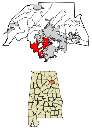
Quincy is a city in and the county seat of Gadsden County, Florida, United States. The population was 7,970 as of the 2020 census. Quincy is part of the Tallahassee metropolitan area.

<span class="mw-page-title-main">Jennings, Florida</span> Town in the state of Florida, United States

Jennings is a town in Hamilton County, Florida, United States. The population was 878 at the 2010 census, up from 833 at the 2000 census. Actor Andrew Prine was born here.

<span class="mw-page-title-main">Valrico, Florida</span> Census-designated place in Florida, United States

Valrico is a census-designated place (CDP) in Hillsborough County, Florida, United States. The population was 35,545 at the 2010 census, up from 6,582 at the 2000 census.

<span class="mw-page-title-main">Country Club, Florida</span> Census-designated place in Florida, United States

Country Club is a census-designated place and a suburban unincorporated community located in northwest Miami-Dade County, Florida, United States. It is named after the Country Club of Miami, which was established in 1961 in what was then an unpopulated and undeveloped section of the county. The population was 49,967 at the 2020 census, up from 3,408 in 1990.

<span class="mw-page-title-main">Oakland, Florida</span> Town in the state of Florida, United States

Oakland is a town in Orange County, Florida, United States. The population was 3,516 at the 2020 Census, representing a growth of 38.5% over the population of 2,538 recorded during the 2010 census. It is part of the Orlando–Kissimmee Metropolitan Statistical Area.

<span class="mw-page-title-main">Trinity, Florida</span> CDP in Florida, United States

Trinity is a census-designated place (CDP) in Pasco County, Florida, United States. The population was 10,907 in 2010, according to the most recent census. The Trinity Community is named after Trinity College of Florida, a Bible college founded in 1932, when it relocated to the first occupied site in the communities developed by James Gills in the late 1980s. The main plaza is found near the high school, known as Mitchell Ranch Plaza. Trinity is located at the junction where Pasco, Hillsborough and Pinellas Counties meet. The community of Longleaf is located in Trinity and it is believed that the “Welcome Plank” originated in Longleaf.

<span class="mw-page-title-main">Greensboro, Georgia</span> Town in Georgia, United States

Greensboro is a town in and the county seat of Greene County, Georgia, United States. Its population was 3,648 as of the 2020 census. The city is located approximately halfway between Atlanta and Augusta on Interstate 20.

<span class="mw-page-title-main">Crystal Lawns, Illinois</span> Census designated place

Crystal Lawns is a census-designated place (CDP) in Will County, Illinois, United States. The population was 1,830 at the 2020 census.

<span class="mw-page-title-main">Vado, New Mexico</span> Place and community in the United States

Vado is an unincorporated community and census-designated place (CDP) in Doña Ana County, New Mexico, United States. The population was 3,194 at the 2010 census. The ZIP code for Vado is 88072, its area code is 575, and it is part of the Las Cruces Metropolitan Statistical Area.

<span class="mw-page-title-main">Madison, North Carolina</span> Town in North Carolina, United States

Madison is a town located in Rockingham County, North Carolina. At the 2020 census, the town had a total population of 2,132. Madison is part of the Greensboro-High Point Metropolitan Statistical Area of the Piedmont Triad metro region. It was home to the corporate headquarters of Remington Arms until 2020, when the company was made defunct by bankruptcy proceedings. It is still home to Marlin Firearms, which was an asset of Remington now owned by Sturm, Ruger & Co.

<span class="mw-page-title-main">Chest Township, Clearfield County, Pennsylvania</span> Township in Pennsylvania, United States

Chest Township is a township in Clearfield County, Pennsylvania, United States. The population was 511 at the 2020 census.

<span class="mw-page-title-main">Williamston, South Carolina</span> Town in South Carolina, United States

Williamston is a town in Anderson County, South Carolina. The population was 4,043 at the 2020 census.

References

  1. "2020 U.S. Gazetteer Files". United States Census Bureau. Retrieved October 31, 2021.
  2. 1 2 "U.S. Census website". United States Census Bureau . Retrieved January 31, 2008.
  3. "US Board on Geographic Names". United States Geological Survey. October 25, 2007. Retrieved January 31, 2008.
  4. 1 2 "Geographic Identifiers: 2010 Demographic Profile Data (G001): Greensboro town, Florida". American Factfinder. U.S. Census Bureau. Retrieved November 21, 2016.[ dead link ]
  5. "US Gazetteer files: 2010, 2000, and 1990". United States Census Bureau. February 12, 2011. Retrieved April 23, 2011.
  6. "Census of Population and Housing". Census.gov. Retrieved June 4, 2015.
  7. "Explore Census Data". data.census.gov. Retrieved March 5, 2022.
  8. "GREENSBORO." U.S. Postal Service. Retrieved on April 7, 2017.
  9. "Fire Station Locations." Gadsden County, Florida. Retrieved on April 7, 2017.
  10. 1 2 "vet-library-fire.jpg." Town of Greensboro. Retrieved on April 7, 2017.
  11. "Big Bend Transit | COORDINATED TRANSPORTATION SYSTEM OF GADSDEN COUNTY". www.bigbendtransit.org. Retrieved January 31, 2019.
  12. "Schools." Town of Greensboro. Retrieved on April 5, 2017.
  13. "SCHOOL MERGERS NOT POPULAR AT WEST GADSDEN". Havana Herald. March 3, 2017. Archived from the original on April 6, 2017. Retrieved April 6, 2017.