Lakewood Park, Florida

Last updated

Lakewood Park, Florida
St. Lucie County Florida Incorporated and Unincorporated areas Lakewood Park Highlighted.svg
Location in St. Lucie County and the state of Florida
Coordinates: 27°32′31″N80°23′47″W / 27.54194°N 80.39639°W / 27.54194; -80.39639
Country Flag of the United States.svg  United States
State Flag of Florida.svg  Florida
County   St. Lucie
Area
[1]
  Total6.89 sq mi (17.85 km2)
  Land6.65 sq mi (17.21 km2)
  Water0.25 sq mi (0.64 km2)
Elevation
20 ft (6 m)
Population
 (2020)
  Total12,510
  Density1,882.05/sq mi (726.71/km2)
Time zone UTC-5 (Eastern (EST))
  Summer (DST) UTC-4 (EDT)
FIPS code 12-39062 [2]
GNIS feature ID0308007 [3]

Lakewood Park is a Census-designated place [4] in St. Lucie County, Florida, United States. The population was 11,323 at the 2010 census. It is part of the Port St. Lucie Metropolitan Statistical Area.

Contents

Geography

Lakewood Park is located at 27°32′31″N80°23′47″W / 27.54194°N 80.39639°W / 27.54194; -80.39639 (27.542069, -80.396380). [5]

According to the United States Census Bureau, the CDP has a total area of 6.9 square miles (18 km2), of which 6.7 square miles (17 km2) is land and 0.2 square miles (0.52 km2) (3.18%) is water.

Demographics

Historical population
CensusPop.Note
2000 10,458
2010 11,3238.3%
2020 12,51010.5%
U.S. Decennial Census [6]

As of the census [2] of 2000, there were 10,458 people, 4,562 households, and 3,166 families residing in the CDP. The population density was 1,561.6 inhabitants per square mile (602.9/km2). There were 5,124 housing units at an average density of 765.1 per square mile (295.4/km2). The racial makeup of the CDP was 91.81% White, 5.28% African American, 0.36% Native American, 0.62% Asian, 0.06% Pacific Islander, 0.67% from other races, and 1.20% from two or more races. Hispanic or Latino of any race were 2.54% of the population.

There were 4,562 households, out of which 22.8% had children under the age of 18 living with them, 58.2% were married couples living together, 7.7% had a female householder with no husband present, and 30.6% were non-families. 25.9% of all households were made up of individuals, and 15.7% had someone living alone who was 65 years of age or older. The average household size was 2.29 and the average family size was 2.71.

In the CDP, the population was spread out, with 19.8% under the age of 18, 5.5% from 18 to 24, 23.6% from 25 to 44, 21.6% from 45 to 64, and 29.6% who were 65 years of age or older. The median age was 46 years. For every 100 females, there were 94.6 males. For every 100 females age 18 and over, there were 90.9 males.

The median income for a household in the CDP was $35,805, and the median income for a family was $41,069. Males had a median income of $30,271 versus $22,872 for females. The per capita income for the CDP was $19,041. About 8.2% of families and 9.5% of the population were below the poverty line, including 14.1% of those under age 18 and 5.6% of those age 65 or over.

Related Research Articles

<span class="mw-page-title-main">Henry County, Iowa</span> County in Iowa, United States

Henry County is a county located in the U.S. state of Iowa. As of the 2020 census, the population was 20,482. The county seat is Mount Pleasant. The county was named for General Henry Dodge, governor of Wisconsin Territory.

<span class="mw-page-title-main">South Beach, Florida</span> Census-designated place in Florida, United States

South Beach is a census-designated place (CDP) on North Hutchinson Island in Indian River County, Florida, United States. The population was 3,501 at the 2010 census. It is ranked tenth in Florida locations by per capita income as of 2010.

<span class="mw-page-title-main">Winter Beach, Florida</span> Census-designated place in Florida, United States

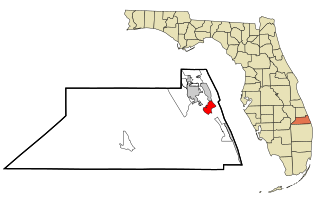
Winter Beach is a census-designated place (CDP) in Indian River County, Florida, United States. The population was 2,067 at the 2010 census, up from 965 at the 2000 census. It is part of the Sebastian–Vero Beach Metropolitan Statistical Area.

<span class="mw-page-title-main">North River Shores, Florida</span> Census-designated place in Florida, United States

North River Shores is an unincorporated area and census-designated place (CDP) in Martin County, Florida, United States. The population was 3,459 at the 2020 census, up from 3,079 in 2010. It is part of the Port St. Lucie Metropolitan Statistical Area.

<span class="mw-page-title-main">Port Salerno, Florida</span> Census-designated place in Florida, United States

Port Salerno is an unincorporated community and census-designated place (CDP) in Martin County, Florida, United States. The population was 10,401 at the 2020 census. It is part of the Port St. Lucie Metropolitan Statistical Area.

<span class="mw-page-title-main">Rio, Florida</span> Census-designated place in Florida, United States

Rio is an unincorporated community and census-designated place (CDP) in Martin County, Florida, United States. The population was 980 at the 2020 census. Rio is pronounced locally as if it were spelled "Rye-oh". It is part of the Port St. Lucie Metropolitan Statistical Area.

<span class="mw-page-title-main">Fort Pierce North, Florida</span> CDP in Florida, United States

Fort Pierce North is a census-designated place (CDP) in St. Lucie County, Florida, United States. Per the 2020 census, the population was 6,904. It is part of the Port St. Lucie Metropolitan Statistical Area.

<span class="mw-page-title-main">Fort Pierce South, Florida</span> CDP in Florida, United States

Fort Pierce South is a census-designated place (CDP) in St. Lucie County, Florida, United States. The population was 5,062 at the 2010 census. It is part of the Port St. Lucie Metropolitan Statistical Area.

<span class="mw-page-title-main">Hutchinson Island South, Florida</span> CDP in Florida, United States

Hutchinson Island South is a census-designated place (CDP) on the barrier island of Hutchinson Island in St. Lucie County, Florida, United States. The South in its name refers to its location in the southern part of St. Lucie County, as it is actually in the central part of the island as a whole. The population was 4,846 at the 2000 census. It is part of the Port St. Lucie Metropolitan Statistical Area. Its mail is delivered from Jensen Beach 34957 in nearby Martin County. The Jensen Beach post office has a postal contract substation known as Hutchinson Beach located at 11007 South Ocean Drive, but it offers only post office boxes and counter services.

<span class="mw-page-title-main">Indian River Estates, Florida</span> CDP in Florida, United States

Indian River Estates is a census-designated place (CDP) in St. Lucie County, Florida, United States. The population was 6,220 at the 2010 census. It is part of the Port St. Lucie Metropolitan Statistical Area.

<span class="mw-page-title-main">River Park, Florida</span> Census-designated place in Florida, United States

River Park is a census-designated place (CDP) in St. Lucie County, Florida, United States. The population was 5,222 at the 2010 census, at which time it was listed as Port St. Lucie-River Park. It is part of the Port St. Lucie Metropolitan Statistical Area.

<span class="mw-page-title-main">White City, St. Lucie County, Florida</span> CDP in Florida, United States

White City is a census-designated place (CDP) in St. Lucie County, Florida, United States. The population was 3,719 at the 2010 census. It is part of the Port St. Lucie Metropolitan Statistical Area.

<span class="mw-page-title-main">Lake Summerset, Illinois</span> Census Designated Place in Illinois, United States

Lake Summerset is a census-designated place (CDP) in Stephenson and Winnebago counties in Illinois. The population was 2,048 at the 2010 census.

<span class="mw-page-title-main">Lakewood Shores, Illinois</span> Census-designated place in Illinois, United States

Lakewood Shores is a census-designated place (CDP) in Will County, Illinois, United States. The population was 665 at the 2020 census.

<span class="mw-page-title-main">Whaleyville, Maryland</span> CDP in Maryland, United States

Whaleyville is a census-designated place in Worcester County, Maryland, United States. The population was 149 at the 2010 census. It is part of the Salisbury, Maryland-Delaware Metropolitan Statistical Area.

<span class="mw-page-title-main">Antreville, South Carolina</span> CDP in South Carolina, United States

Antreville is a census-designated place (CDP) in Abbeville County, South Carolina. The population was 14 at the 2020 census.

Lakewood is a census-designated place (CDP) in Sumter County, South Carolina, United States. The population was 2,603 at the 2000 census. It is included in the Sumter, South Carolina Metropolitan Statistical Area.

<span class="mw-page-title-main">Elk Plain, Washington</span> CDP in Washington, United States

Elk Plain is a census-designated place (CDP) in Pierce County, Washington, United States. The population was 14,534 at the 2020 census.

<span class="mw-page-title-main">Kittery (CDP), Maine</span> Census-designated place in Maine, United States

Kittery is a census-designated place (CDP) consisting of the main village in the town of Kittery in York County, Maine, United States. The village is also known as Kittery Foreside. The population of the CDP was 4,562 at the 2010 census. It is part of the Portland–South Portland–Biddeford, Maine Metropolitan Statistical Area.

<span class="mw-page-title-main">Lakewood (CDP), New Jersey</span> Populated place in Ocean County, New Jersey, US

Lakewood is an unincorporated community and census-designated place (CDP) located within Lakewood Township, in Ocean County, in the U.S. state of New Jersey. As of the 2010 United States Census, the CDP's population was 53,805.

References

  1. "2020 U.S. Gazetteer Files". United States Census Bureau. Retrieved October 31, 2021.
  2. 1 2 "U.S. Census website". United States Census Bureau . Retrieved January 31, 2008.
  3. "US Board on Geographic Names". United States Geological Survey. October 25, 2007. Retrieved January 31, 2008.
  4. "QuickFacts: Lakewood Park CDP, Florida; United States". U.S. Census Bureau. Retrieved September 16, 2021.
  5. "US Gazetteer files: 2010, 2000, and 1990". United States Census Bureau. February 12, 2011. Retrieved April 23, 2011.
  6. "Census of Population and Housing". Census.gov. Retrieved June 4, 2016.