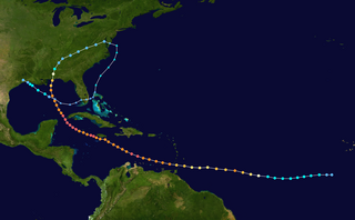
The 2004 Atlantic hurricane season was a very deadly, destructive, and extremely active Atlantic hurricane season, with over 3,200 deaths and more than $61 billion in damage. More than half of the 16 tropical cyclones brushed or struck the United States. Due to the development of a Modoki El Niño – a rare type of El Niño in which unfavorable conditions are produced over the eastern Pacific instead of the Atlantic basin due to warmer sea surface temperatures farther west along the equatorial Pacific – activity was above average. The season officially began on June 1 and ended on November 30, though the season's last storm, Otto, dissipated on December 3, extending the season beyond its traditional boundaries. The first storm, Alex, developed offshore of the Southeastern United States on July 31, one of the latest dates on record to see the formation of the first system in an Atlantic hurricane season. It brushed the Carolinas and the Mid-Atlantic, causing one death and $7.5 million (2004 USD) in damage. Several storms caused only minor damage, including tropical storms Bonnie, Earl, Hermine, and Matthew. In addition, hurricanes Danielle, Karl, and Lisa, Tropical Depression Ten, Subtropical Storm Nicole and Tropical Storm Otto had no effect on land while tropical cyclones. The season was the first to exceed 200 units in accumulated cyclone energy (ACE) since 1995, mostly from Hurricane Ivan, the storm produced the highest ACE. Ivan generated the second-highest ACE in the Atlantic, only behind 1899 San Ciriaco Hurricane.

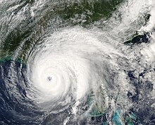
Hurricane Ivan was a large, long-lived, Cape Verde hurricane that caused widespread damage in the Caribbean and United States. The cyclone was the ninth named storm, the sixth hurricane and the fourth major hurricane of the active 2004 Atlantic hurricane season.

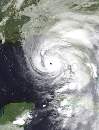
Hurricane Jeanne was a Category 3 hurricane that struck the Caribbean and the Eastern United States in September 2004. It was the deadliest hurricane in the Atlantic basin since Mitch in 1998. It was the tenth named storm, the seventh hurricane, and the fifth major hurricane of the season, as well as the third hurricane and fourth named storm of the season to make landfall in Florida. After wreaking havoc on Hispaniola, Jeanne struggled to reorganize, eventually strengthening and performing a complete loop over the open Atlantic. It headed westwards, strengthening into a Category 3 hurricane and passing over the islands of Great Abaco and Grand Bahama in the Bahamas on September 25. Jeanne made landfall later in the day in Florida just two miles from where Hurricane Frances had struck a mere three weeks earlier.
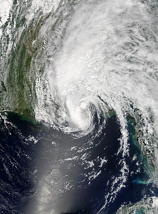
Hurricane Dennis was an early-forming major hurricane in the Caribbean and Gulf of Mexico during the record-breaking 2005 Atlantic hurricane season. Dennis was the fourth named storm, second hurricane, and first major hurricane of the season. Forming in July, the hurricane became the strongest Atlantic hurricane ever to form before August at the time, a title it held for only six days before being surpassed by Hurricane Emily.

Hurricane Erin was the first hurricane to strike the contiguous United States since Hurricane Andrew in 1992. The fifth tropical cyclone, fifth named storm, and second hurricane of the unusually active 1995 Atlantic hurricane season, Erin developed from a tropical wave near the southeastern Bahamas on July 31. Moving northwestward, the cyclone intensified into a Category 1 hurricane on the Saffir–Simpson scale near Rum Cay about 24 hours later. After a brief jog to the north-northwest on August 1, Erin began moving to the west-northwest. The cyclone then moved over the northwestern Bahamas, including the Abaco Islands and Grand Bahama. Early on August 2, Erin made landfall near Vero Beach, Florida, with winds of 85 mph (137 km/h). The hurricane weakened while crossing the Florida peninsula and fell to tropical storm intensity before emerging into the Gulf of Mexico later that day.
Tropical Storm Arlene was an unusually large and early-forming tropical storm, being the first of twenty-eight different storms during the 2005 Atlantic hurricane season, which would become the second most active season on record. Tropical Storm Arlene formed near Honduras on June 8 and moved northwards. It crossed western Cuba on June 10 and strengthened to just under hurricane strength before making its final landfall on the Florida Panhandle the next day. The storm weakened as it continued to move north over the United States, becoming extratropical on June 13. Arlene was responsible for two deaths and minor damage.

Tropical Depression Ten was a short-lived tropical cyclone that made landfall on the Florida Panhandle in September 2007. The system developed as a subtropical depression on September 21 in the northeastern Gulf of Mexico from the interaction of a tropical wave, the tail end of a cold front, and an upper-level low. Initially containing a poorly defined circulation and intermittent thunderstorm activity, the system transitioned into a tropical depression after convection increased over the center. Tracking northwestward, the depression moved ashore near Fort Walton Beach early on September 22 and dissipated over southeastern Alabama shortly thereafter.
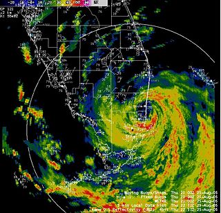
The meteorological history of Hurricane Ivan, the longest tracked tropical cyclone of the 2004 Atlantic hurricane season, lasted from late August through late September. The hurricane developed from a tropical wave that moved off the coast of Africa on August 31. Tracking westward due to a ridge, favorable conditions allowed it to develop into Tropical Depression Nine on September 2 in the deep tropical Atlantic Ocean. The cyclone gradually intensified until September 5, when it underwent rapid deepening and reached Category 4 status on the Saffir-Simpson Hurricane Scale; at the time Ivan was the southernmost major North Atlantic hurricane on record.

The effects of Hurricane Dennis in Florida included 14 deaths and $1.5 billion in damage. The tropical wave that became Hurricane Dennis formed on June 29, 2005, and proceeded westward across the Atlantic Ocean. It became a tropical depression on July 4, a tropical storm on July 5, and a hurricane on July 7. Dennis rapidly intensified to attain Category 4 status on the Saffir-Simpson Hurricane Scale, and made landfall in Cuba where it weakened to Category 1 status, before re-emerging in the Gulf of Mexico and re–intensifying. The storm made landfall as a Category 3 hurricane on Santa Rosa Island on July 10.
The Effects of Hurricane Dennis in Alabama included $127 million (2005 USD) in damage and three injuries. Dennis made landfall on the Florida Panhandle as a Category 3 hurricane on the Saffir-Simpson scale on July 10, 2005, before tracking over Alabama as a minimal hurricane. In preparation for the storm, about 500,000 people were given evacuation orders, and the Red Cross opened 87 shelters. As a result, all southbound lanes of Interstate 65 from Mobile to Montgomery were closed.

The meteorological history of Hurricane Jeanne lasted for about two weeks in September 2004. Hurricane Jeanne was the eleventh tropical cyclone, tenth named storm, seventh hurricane, and sixth major hurricane of the 2004 Atlantic hurricane season. It formed from a tropical wave on September 13 near the Lesser Antilles, and encountered favorable enough conditions to reach tropical storm status. Jeanne strengthened further in the eastern Caribbean, becoming a strong tropical storm and developing an eye before striking Puerto Rico on September 15. Remaining well-organized, it attained hurricane status before hitting the eastern tip of the Dominican Republic on September 16.

Tropical Storm Fay was a strong and unusual tropical storm that moved erratically across the state of Florida and the Caribbean Sea. The sixth named storm of the 2008 Atlantic hurricane season, Fay formed from a vigorous tropical wave on August 15 over the Dominican Republic. It passed over the island of Hispaniola, into the Gulf of Gonâve, across the island of Cuba, and made landfall on the Florida Keys late in the afternoon of August 18 before veering into the Gulf of Mexico. It again made landfall near Naples, Florida, in the early hours of August 19 and progressed northeast through the Florida peninsula, emerging into the Atlantic Ocean near Melbourne on August 20. Extensive flooding took place in parts of Florida as a result of its slow movement. On August 21, it made landfall again near New Smyrna Beach, Florida, moving due west across the Panhandle, crossing Gainesville and Panama City, Florida. As it zigzagged from water to land, it became the first storm in recorded history to make landfall in Florida four times. Thirty-six deaths were blamed on Fay. The storm also resulted in one of the most prolific tropical cyclone related tornado outbreaks on record. A total of 81 tornadoes touched down across five states, three of which were rated as EF2. Damage from Fay was heavy, estimated at $560 million.
The effects of Hurricane Katrina in Florida were in both the southern portion of the state and in the panhandle. After developing on August 23, Katrina made landfall near the border of Broward and Miami-Dade counties with 80 mph (130 km/h) winds on August 25. While it was crossing the state, the hurricane's convection was asymmetrical, primarily located to the south and east of the center. As a result, high rainfall totals occurred in the Miami area, peaking at 16.43 in (417 mm) in Perrine. The rains caused flooding, and the combination of rains and winds downed trees and power lines, leaving 1.45 million people without power. Damage in South Florida was estimated at $523 million (2005 USD), mostly as a result of crop damage. Further south, the hurricane spawned a tornado in the Florida Keys. In the island chain, Katrina caused heavy rainfall and gusty winds.

The effects of Hurricane Georges in Florida lasted for more than a week in late September and early October in 1998. After developing from a tropical wave to the south of Cape Verde on September 15, Georges moved steadily west-northwestward and peaked as a strong Category 4 hurricane on the Saffir–Simpson scale on September 20. After weakening slightly to a Category 3, the cyclone proceeded to strike Antigua, Saint Kitts and Nevis, Puerto Rico, Dominican Republic, and Cuba. Georges emerged into the Straits of Florida as a Category 1, but re-strengthened slightly to a Category 2 before making landfall in Key West, Florida, on September 25. The hurricane continued northwestward into the Gulf of Mexico and struck near Biloxi, Mississippi, on September 28. After moving inland, Georges turned eastward and crossing into the Florida Panhandle on the next day. By October 1, the system dissipated near the northeast Florida–southeast Georgia coast.

The 1932 Florida–Alabama hurricane was a tropical cyclone that made two separate landfalls on the United States, causing devastation in affected areas. The third named storm and hurricane of the 1932 Atlantic hurricane season, it developed from a tropical disturbance north of Hispaniola on August 26. Slowly moving towards the west-northwest, the system intensified to tropical storm strength before making landfall on South Florida early on August 30. After crossing the Florida peninsula and entering the Gulf of Mexico, the system reached peak intensity as a Category 1 hurricane, before subsequently making its final landfall near the Mississippi–Alabama border on September 1. Over land, the hurricane weakened, and after becoming an extratropical cyclone on September 2, merged with another extratropical system over Quebec on September 4.

Hurricane Sally was a destructive and slow-moving Atlantic hurricane that was the first hurricane to make landfall in the U.S. state of Alabama since Ivan in 2004, coincidentally on the same date in the same place. The eighteenth named storm and seventh hurricane of the extremely active 2020 Atlantic hurricane season, Sally developed from an area of disturbed weather which was first monitored over the Bahamas on September 10. The system grew a broad area of low-pressure on September 11, and was designated as a tropical depression late that day. Early the next day, the depression made landfall at Key Biscayne and subsequently strengthened into Tropical Storm Sally that afternoon. Moderate northwesterly shear prevented significant intensification for the first two days, but convection continued to grow towards the center and Sally slowly intensified. On September 14, a center reformation into the center of the convection occurred, and data from a hurricane hunter reconnaissance aircraft showed that Sally had rapidly intensified into a strong Category 1 hurricane. However, an increase in wind shear and upwelling of colder waters halted the intensification and Sally weakened slightly on September 15 before turning slowly northeastward. Despite this increase in wind shear, it unexpectedly re-intensified, reaching Category 2 status early on September 16 before making landfall at peak intensity at 09:45 UTC on September 16, near Gulf Shores, Alabama, with maximum sustained winds of 110 mph (180 km/h) and a minimum central pressure of 965 millibars (28.5 inHg). The storm rapidly weakened after landfall before transitioning into an extratropical low at 12:00 UTC the next day. Sally's remnants lasted for another day as they moved off the coast of the Southeastern United States before being absorbed into another extratropical storm on September 18.