Hail

Last updated

A large hailstone, about 6 cm (2.4 in) in diameter Granizo.jpg
A large hailstone, about 6 cm (2.4 in) in diameter

Hail is a form of solid precipitation. [1] It is distinct from ice pellets (American English "sleet"), though the two are often confused. [2] It consists of balls or irregular lumps of ice, each of which is called a hailstone. [3] Ice pellets generally fall in cold weather, while hail growth is greatly inhibited during low surface temperatures.

Contents

Unlike other forms of water ice precipitation, such as graupel (which is made of rime ice), ice pellets (which are smaller and translucent), and snow (which consists of tiny, delicately crystalline flakes or needles), hailstones usually measure between 5 mm (0.2 in) and 15 cm (6 in) in diameter. [1] The METAR reporting code for hail 5 mm (0.20 in) or greater is GR, while smaller hailstones and graupel are coded GS.

Hail is possible within most thunderstorms (as it is produced by cumulonimbus), [4] as well as within 2 nmi (3.7 km) of the parent storm. Hail formation requires environments of strong, upward motion of air within the parent thunderstorm (similar to tornadoes) and lowered heights of the freezing level. In the mid-latitudes, hail forms near the interiors of continents, while, in the tropics, it tends to be confined to high elevations.

There are methods available to detect hail-producing thunderstorms using weather satellites and weather radar imagery. Hailstones generally fall at higher speeds as they grow in size, though complicating factors such as melting, friction with air, wind, and interaction with rain and other hailstones can slow their descent through Earth's atmosphere. Severe weather warnings are issued for hail when the stones reach a damaging size, as it can cause serious damage to human-made structures, and, most commonly, farmers' crops.

Definition

Any thunderstorm which produces hail that reaches the ground is known as a hailstorm. [5] An ice crystal with a diameter of >5 mm (0.20 in) is considered a hailstone. [4] Hailstones can grow to 15 cm (6 in) and weigh more than 0.5 kg (1.1 lb). [6]

Unlike ice pellets, hailstones are layered and can be irregular and clumped together.[ citation needed ] Hail is composed of transparent ice or alternating layers of transparent and translucent ice at least 1 mm (0.039 in) thick, which are deposited upon the hailstone as it travels through the cloud, suspended aloft by air with strong upward motion until its weight overcomes the updraft and falls to the ground. Although the diameter of hail is varied, in the United States, the average observation of damaging hail is between 2.5 cm (0.98 in) and golf-ball-sized 4.4 cm (1.75 in). [7]

Stones larger than 2 cm (0.79 in) are usually considered large enough to cause damage. The Meteorological Service of Canada issues severe thunderstorm warnings when hail that size or above is expected. [8] The US National Weather Service has a 1 in (25 mm) diameter threshold, effective January 2010, an increase over the previous threshold of 0.75 in (1.9 cm) hail. [9] Other countries have different thresholds according to local sensitivity to hail; for instance, grape-growing areas could be adversely impacted by smaller hailstones. Hailstones can be very large or very small, depending on how strong the updraft is: weaker hailstorms produce smaller hailstones than stronger hailstorms (such as supercells), as the more powerful updrafts in a stronger storm can keep larger hailstones aloft.

Formation

Hail forms in strong thunderstorm clouds, particularly those with intense updrafts, high liquid-water content, great vertical extent, large water droplets, and where a good portion of the cloud layer is below freezing (0 °C; 32 °F). [4] These types of strong updrafts can also indicate the presence of a tornado. [10] The growth rate of hailstones is impacted by factors such as higher elevation, lower freezing zones, and wind shear. [11]

Layer nature of the hailstones

Hail shaft Hailshaft.jpg
Hail shaft

Like other precipitation in cumulonimbus clouds, hail begins as water droplets. As the droplets rise and the temperature goes below freezing, they become supercooled water and will freeze on contact with condensation nuclei. A cross-section through a large hailstone shows an onion-like structure. This means that the hailstone is made of thick and translucent layers, alternating with layers that are thin, white and opaque. Former theory suggested that hailstones were subjected to multiple descents and ascents, falling into a zone of humidity and refreezing as they were uplifted.[ citation needed ] This up and down motion was thought to be responsible for the successive layers of the hailstone. New research, based on theory as well as field study, has shown this is not necessarily true.[ citation needed ]

The storm's updraft, with upwardly directed wind speeds as high as 110 mph (180 km/h), [12] blows the forming hailstones up the cloud. As the hailstone ascends, it passes into areas of the cloud where the concentration of humidity and supercooled water droplets varies. The hailstone's growth rate changes depending on the variation in humidity and supercooled water droplets that it encounters. The accretion rate of these water droplets is another factor in the hailstone's growth. When the hailstone moves into an area with a high concentration of water droplets, it captures the latter and acquires a translucent layer. Should the hailstone move into an area where mostly water vapor is available, it acquires a layer of opaque white ice. [13]

Severe thunderstorms containing hail can exhibit a characteristic green coloration Hail clouds.jpg
Severe thunderstorms containing hail can exhibit a characteristic green coloration

Furthermore, the hailstone's speed depends on its position in the cloud's updraft and its mass. This determines the varying thicknesses of the layers of the hailstone. The accretion rate of supercooled water droplets onto the hailstone depends on the relative velocities between these water droplets and the hailstone itself. This means that generally the larger hailstones will form some distance from the stronger updraft, where they can pass more time growing. [13] As the hailstone grows, it releases latent heat, which keeps its exterior in a liquid phase. Because it undergoes "wet growth", the outer layer is sticky (i.e. more adhesive), so a single hailstone may grow by collision with other smaller hailstones, forming a larger entity with an irregular shape. [15]

Hail can also undergo "dry growth", in which the latent heat release through freezing is not enough to keep the outer layer in a liquid state. Hail forming in this manner appears opaque due to small air bubbles that become trapped in the stone during rapid freezing. These bubbles coalesce and escape during the "wet growth" mode, and the hailstone is more clear. The mode of growth for a hailstone can change throughout its development, and this can result in distinct layers in a hailstone's cross-section. [16]

The hailstone will keep rising in the thunderstorm until its mass can no longer be supported by the updraft. This may take at least 30 minutes, based on the force of the updrafts in the hail-producing thunderstorm, whose top is usually greater than 10 km high. It then falls toward the ground while continuing to grow, based on the same processes, until it leaves the cloud. It will later begin to melt as it passes into air above freezing temperature. [17]

Heavy hailstorm at Thakurgaon, Northern Bangladesh (April 2022)

Thus, a unique trajectory in the thunderstorm is sufficient to explain the layer-like structure of the hailstone. The only case in which multiple trajectories can be discussed is in a multicellular thunderstorm, where the hailstone may be ejected from the top of the "mother" cell and captured in the updraft of a more intense "daughter" cell. This, however, is an exceptional case. [13]

Factors favoring hail

Hail is most common within continental interiors of the mid-latitudes, as hail formation is considerably more likely when the freezing level is below the altitude of 11,000 ft (3,400 m). [18] Movement of dry air into strong thunderstorms over continents can increase the frequency of hail by promoting evaporational cooling, which lowers the freezing level of thunderstorm clouds, giving hail a larger volume to grow in. Accordingly, hail is less common in the tropics despite a much higher frequency of thunderstorms than in the mid-latitudes because the atmosphere over the tropics tends to be warmer over a much greater altitude. Hail in the tropics occurs mainly at higher elevations. [19]

Hail growth becomes vanishingly small when air temperatures fall below −30 °C (−22 °F), as supercooled water droplets become rare at these temperatures. [18] Around thunderstorms, hail is most likely within the cloud at elevations above 20,000 ft (6,100 m). Between 10,000 ft (3,000 m) and 20,000 ft (6,100 m), 60% of hail is still within the thunderstorm, though 40% now lies within the clear air under the anvil. Below 10,000 ft (3,000 m), hail is equally distributed in and around a thunderstorm to a distance of 2 nmi (3.7 km). [20]

Climatology

Hail occurs most frequently within continental interiors at mid-latitudes and is less common in the tropics, despite a much higher frequency of thunderstorms than in the mid-latitudes. [21] Hail is also much more common along mountain ranges because mountains force horizontal winds upwards (known as orographic lifting), thereby intensifying the updrafts within thunderstorms and making hail more likely. [22] The higher elevations also result in there being less time available for hail to melt before reaching the ground. One of the more common regions for large hail is across mountainous northern India, which reported one of the highest hail-related death tolls on record in 1888. [23] China also experiences significant hailstorms. [24] Central Europe and southern Australia also experience a lot of hailstorms. Regions where hailstorms frequently occur are southern and western Germany, northern and eastern France, southern and eastern Benelux, and northern Italy. [25] In southeastern Europe, Croatia and Serbia experience frequent occurrences of hail. [26] Some mediterranean countries register the maximum frequency of hail during the Fall season. [25]

In North America, hail is most common in the area where Colorado, Nebraska, and Wyoming meet, known as "Hail Alley". [27] Hail in this region occurs between the months of March and October during the afternoon and evening hours, with the bulk of the occurrences from May through September. Cheyenne, Wyoming is North America's most hail-prone city with an average of nine to ten hailstorms per season. [28] To the north of this area and also just downwind of the Rocky Mountains is the Hailstorm Alley region of Alberta, which also experiences an increased incidence of significant hail events.

Example of a three-body spike: the weak triangular echoes (pointed by the arrow) behind the red and white thunderstorm core are related to hail inside the storm. Three body scatter spike-NOAA.png
Example of a three-body spike: the weak triangular echoes (pointed by the arrow) behind the red and white thunderstorm core are related to hail inside the storm.

Short-term detection

Weather radar is a very useful tool to detect the presence of hail-producing thunderstorms. However, radar data has to be complemented by a knowledge of current atmospheric conditions which can allow one to determine if the current atmosphere is conducive to hail development.

Modern radar scans many angles around the site. Reflectivity values at multiple angles above ground level in a storm are proportional to the precipitation rate at those levels. Summing reflectivities in the Vertically Integrated Liquid or VIL, gives the liquid water content in the cloud. Research shows that hail development in the upper levels of the storm is related to the evolution of VIL. VIL divided by the vertical extent of the storm, called VIL density, has a relationship with hail size, although this varies with atmospheric conditions and therefore is not highly accurate. [29] Traditionally, hail size and probability can be estimated from radar data by computer using algorithms based on this research. Some algorithms include the height of the freezing level to estimate the melting of the hailstone and what would be left on the ground.

Certain patterns of reflectivity are important clues for the meteorologist as well. The three body scatter spike is an example. This is the result of energy from the radar hitting hail and being deflected to the ground, where they deflect back to the hail and then to the radar. The energy took more time to go from the hail to the ground and back, as opposed to the energy that went directly from the hail to the radar, and the echo is further away from the radar than the actual location of the hail on the same radial path, forming a cone of weaker reflectivities.

More recently, the polarization properties of weather radar returns have been analyzed to differentiate between hail and heavy rain. [30] [31] The use of differential reflectivity (), in combination with horizontal reflectivity () has led to a variety of hail classification algorithms. [32] Visible satellite imagery is beginning to be used to detect hail, but false alarm rates remain high using this method. [33]

Size and terminal velocity

Hailstones ranging in size from few millimetres to over a centimetre in diameter Hailstones.jpg
Hailstones ranging in size from few millimetres to over a centimetre in diameter
Large hailstone with concentric rings Hagelkorn mit Anlagerungsschichten.jpg
Large hailstone with concentric rings

The size of hailstones is best determined by measuring their diameter with a ruler. In the absence of a ruler, hailstone size is often visually estimated by comparing its size to that of known objects, such as coins. [34] Using the objects such as hen's eggs, peas, and marbles for comparing hailstone sizes is imprecise, due to their varied dimensions. The UK organisation, TORRO, also scales for both hailstones and hailstorms. [35]

When observed at an airport, METAR code is used within a surface weather observation which relates to the size of the hailstone. Within METAR code, GR is used to indicate larger hail, of a diameter of at least 0.25 in (6.4 mm). GR is derived from the French word grêle. Smaller-sized hail, as well as snow pellets, use the coding of GS, which is short for the French word grésil. [36]

Terminal velocity of hail, or the speed at which hail is falling when it strikes the ground, varies. It is estimated that a hailstone of 1 cm (0.39 in) in diameter falls at a rate of 9 m/s (20 mph), while stones the size of 8 cm (3.1 in) in diameter fall at a rate of 48 m/s (110 mph). Hailstone velocity is dependent on the size of the stone, its drag coefficient, the motion of wind it is falling through, collisions with raindrops or other hailstones, and melting as the stones fall through a warmer atmosphere. As hailstones are not perfect spheres, it is difficult to accurately calculate their drag coefficient - and, thus, their speed. [37]

Size comparisons to objects

In the United States, the National Weather Service reports hail size as a comparison to everyday objects. Hailstones larger than 1 inch in diameter are denoted as "severe." [38]

NWS Hail Conversion Chart
Diameter (inches)Everyday Object
0.25 - 0.375 Pea
0.50 Small Marble
0.75 Penny
0.88 Nickel
1.00 (15/16") Quarter
1.25 Half Dollar
1.50 Walnut/Ping Pong Ball
1.75 Golf Ball
2.00 Lime
2.50 Tennis Ball
2.75 Baseball
3.00 Large Apple
4.00 Softball
4.50 Grapefruit
4.75 - 5.00 Computer CD/DVD
The largest recorded hailstone in the United States Record hailstone Vivian, SD.jpg
The largest recorded hailstone in the United States

Hail records

Megacryometeors, large rocks of ice that are not associated with thunderstorms, are not officially recognized by the World Meteorological Organization as "hail", which are aggregations of ice associated with thunderstorms, and therefore records of extreme characteristics of megacryometeors are not given as hail records.

Hazards

Early automobiles were not equipped to deal with hail. Wea02208 - Flickr - NOAA Photo Library.jpg
Early automobiles were not equipped to deal with hail.

Hail can cause serious damage, notably to automobiles, aircraft, skylights, glass-roofed structures, livestock, and most commonly, crops. [28] Hail damage to roofs often goes unnoticed until further structural damage is seen, such as leaks or cracks. It is hardest to recognize hail damage on shingled roofs and flat roofs, but all roofs have their own hail damage detection problems. [45] Metal roofs are fairly resistant to hail damage, but may accumulate cosmetic damage in the form of dents and damaged coatings.

Hail is one of the most significant thunderstorm hazards to aircraft. [46] When hailstones exceed 0.5 in (13 mm) in diameter, planes can be seriously damaged within seconds. [47] The hailstones accumulating on the ground can also be hazardous to landing aircraft. Hail is a common nuisance to drivers of automobiles, severely denting the vehicle and cracking or even shattering windshields and windows unless parked in a garage or covered with a shielding material. Wheat, corn, soybeans, and tobacco are the most sensitive crops to hail damage. [23] Hail is one of Canada's most expensive hazards. [48]

Rarely, massive hailstones have been known to cause concussions or fatal head trauma. Hailstorms have been the cause of costly and deadly events throughout history. One of the earliest known incidents occurred around the 9th century in Roopkund, Uttarakhand, India, where 200 to 600 nomads seem to have died of injuries from hail the size of cricket balls. [49]

Accumulations

Accumulated hail in Sydney, Australia (April 2015) Sydneyhailstorm.jpg
Accumulated hail in Sydney, Australia (April 2015)

Narrow zones where hail accumulates on the ground in association with thunderstorm activity are known as hail streaks or hail swaths, [50] which can be detectable by satellite after the storms pass by. [51] Hailstorms normally last from a few minutes up to 15 minutes in duration. [28] Accumulating hail storms can blanket the ground with over 2 in (5.1 cm) of hail, cause thousands to lose power, and bring down many trees. Flash flooding and mudslides within areas of steep terrain can be a concern with accumulating hail. [52]

Depths of up to 18 in (0.46 m) have been reported. A landscape covered in accumulated hail generally resembles one covered in accumulated snow and any significant accumulation of hail has the same restrictive effects as snow accumulation, albeit over a smaller area, on transport and infrastructure. [53] Accumulated hail can also cause flooding by blocking drains, and hail can be carried in the floodwater, turning into a snow-like slush which is deposited at lower elevations.

On somewhat rare occasions, a thunderstorm can become stationary or nearly so while prolifically producing hail and significant depths of accumulation do occur; this tends to happen in mountainous areas, such as the July 29, 2010 case [54] of a foot of hail accumulation in Boulder County, Colorado. On June 5, 2015, hail up to four feet deep fell on one city block in Denver, Colorado. The hailstones, described as between the size of bumble bees and ping pong balls, were accompanied by rain and high winds. The hail fell in only the one area, leaving the surrounding area untouched. It fell for one and a half hours between 10:00 pm and 11:30 pm. A meteorologist for the National Weather Service in Boulder said, "It's a very interesting phenomenon. We saw the storm stall. It produced copious amounts of hail in one small area. It's a meteorological thing." Tractors used to clear the area filled more than 30 dump truck loads of hail. [55]

Hand holding hail in a strawberry patch Hand holding hail in a strawberry patch.jpg
Hand holding hail in a strawberry patch

Research focused on four individual days that accumulated more than 5.9 inches (15 cm) of hail in 30 minutes on the Colorado front range has shown that these events share similar patterns in observed synoptic weather, radar, and lightning characteristics, [56] suggesting the possibility of predicting these events prior to their occurrence. A fundamental problem in continuing research in this area is that, unlike hail diameter, hail depth is not commonly reported. The lack of data leaves researchers and forecasters in the dark when trying to verify operational methods. A cooperative effort between the University of Colorado and the National Weather Service is in progress. The joint project's goal is to enlist the help of the general public to develop a database of hail accumulation depths. [57]

Suppression and prevention

Hail cannon in an old castle in Banska Stiavnica, Slovakia Banska Stiavnica Cannon-1.JPG
Hail cannon in an old castle in Banska Stiavnica, Slovakia

During the Middle Ages, people in Europe used to ring church bells and fire cannons to try to prevent hail, and the subsequent damage to crops. Updated versions of this approach are available as modern hail cannons. Cloud seeding after World War II was done to eliminate the hail threat, [12] particularly across the Soviet Union, where it was claimed a 70–98% reduction in crop damage from hail storms was achieved by deploying silver iodide in clouds using rockets and artillery shells. [58] [59] But these effects have not been replicated in randomized trials conducted in the West. [60] Hail suppression programs have been undertaken by 15 countries between 1965 and 2005. [12] [23]

See also

Related Research Articles

<span class="mw-page-title-main">Ice</span> Frozen water: the solid state of water

Ice is water that is frozen into a solid state, typically forming at or below temperatures of 0 °C, 32 °F, or 273.15 K. As a naturally occurring crystalline inorganic solid with an ordered structure, ice is considered to be a mineral. Depending on the presence of impurities such as particles of soil or bubbles of air, it can appear transparent or a more or less opaque bluish-white color.

<span class="mw-page-title-main">Thunderstorm</span> Type of weather with lightning and thunder

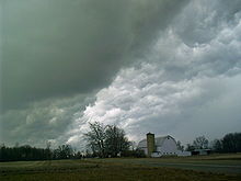
A thunderstorm, also known as an electrical storm or a lightning storm, is a storm characterized by the presence of lightning and its acoustic effect on the Earth's atmosphere, known as thunder. Relatively weak thunderstorms are sometimes called thundershowers. Thunderstorms occur in a type of cloud known as a cumulonimbus. They are usually accompanied by strong winds and often produce heavy rain and sometimes snow, sleet, or hail, but some thunderstorms produce little precipitation or no precipitation at all. Thunderstorms may line up in a series or become a rainband, known as a squall line. Strong or severe thunderstorms include some of the most dangerous weather phenomena, including large hail, strong winds, and tornadoes. Some of the most persistent severe thunderstorms, known as supercells, rotate as do cyclones. While most thunderstorms move with the mean wind flow through the layer of the troposphere that they occupy, vertical wind shear sometimes causes a deviation in their course at a right angle to the wind shear direction.

A storm is any disturbed state of the natural environment or the atmosphere of an astronomical body. It may be marked by significant disruptions to normal conditions such as strong wind, tornadoes, hail, thunder and lightning, heavy precipitation, heavy freezing rain, strong winds, wind transporting some substance through the atmosphere such as in a dust storm, among other forms of severe weather.

Freezing rain is rain maintained at temperatures below freezing by the ambient air mass that causes freezing on contact with surfaces. Unlike a mixture of rain and snow or ice pellets, freezing rain is made entirely of liquid droplets. The raindrops become supercooled while passing through a sub-freezing layer of air hundreds of meters above the ground, and then freeze upon impact with any surface they encounter, including the ground, trees, electrical wires, aircraft, and automobiles. The resulting ice, called glaze ice, can accumulate to a thickness of several centimeters and cover all exposed surfaces. The METAR code for freezing rain is FZRA.

<span class="mw-page-title-main">Supercell</span> Thunderstorm that is characterized by the presence of a mesocyclone

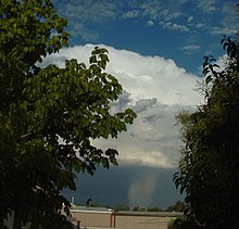
A supercell is a thunderstorm characterized by the presence of a mesocyclone; a deep, persistently rotating updraft. Due to this, these storms are sometimes referred to as rotating thunderstorms. Of the four classifications of thunderstorms, supercells are the overall least common and have the potential to be the most severe. Supercells are often isolated from other thunderstorms, and can dominate the local weather up to 32 kilometres (20 mi) away. They tend to last 2–4 hours.

<span class="mw-page-title-main">Mesocyclone</span> Region of rotation within a powerful thunderstorm

A mesocyclone is a meso-gamma mesoscale region of rotation (vortex), typically around 2 to 6 mi in diameter, most often noticed on radar within thunderstorms. In the northern hemisphere it is usually located in the right rear flank of a supercell, or often on the eastern, or leading, flank of a high-precipitation variety of supercell. The area overlaid by a mesocyclone’s circulation may be several miles (km) wide, but substantially larger than any tornado that may develop within it, and it is within mesocyclones that intense tornadoes form.

<span class="mw-page-title-main">Severe thunderstorm warning</span> Weather warning indicating an observed severe thunderstorm

A severe thunderstorm warning is a type of public warning for severe weather that is issued by weather forecasting agencies worldwide when one or more severe thunderstorms have been detected by Doppler weather radar, observed by weather spotters, or reported by an emergency management agency, law enforcement, or the general public. Unlike a watch, a warning is issued to areas in the direct path of active severe thunderstorms, that are expecting a direct impact typically within an hour. Severe thunderstorms can cause property damage and injury due to large hail, high winds, and flooding due to torrential rainfall. The exact criteria to issue a warning varies from country to country.

<span class="mw-page-title-main">Precipitation</span> Product of the condensation of atmospheric water vapor that falls under gravity

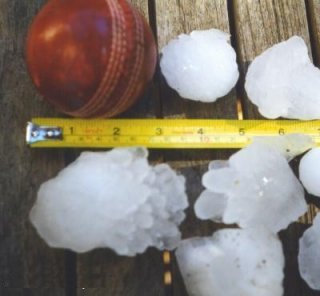
In meteorology, precipitation is any product of the condensation of atmospheric water vapor that falls from clouds due to gravitational pull. The main forms of precipitation include drizzle, rain, sleet, snow, ice pellets, graupel and hail. Precipitation occurs when a portion of the atmosphere becomes saturated with water vapor, so that the water condenses and "precipitates" or falls. Thus, fog and mist are not precipitation but colloids, because the water vapor does not condense sufficiently to precipitate. Two processes, possibly acting together, can lead to air becoming saturated: cooling the air or adding water vapor to the air. Precipitation forms as smaller droplets coalesce via collision with other rain drops or ice crystals within a cloud. Short, intense periods of rain in scattered locations are called showers.

<span class="mw-page-title-main">Cloud physics</span> Study of the physical processes in atmospheric clouds

Cloud physics is the study of the physical processes that lead to the formation, growth and precipitation of atmospheric clouds. These aerosols are found in the troposphere, stratosphere, and mesosphere, which collectively make up the greatest part of the homosphere. Clouds consist of microscopic droplets of liquid water, tiny crystals of ice, or both, along with microscopic particles of dust, smoke, or other matter, known as condensation nuclei. Cloud droplets initially form by the condensation of water vapor onto condensation nuclei when the supersaturation of air exceeds a critical value according to Köhler theory. Cloud condensation nuclei are necessary for cloud droplets formation because of the Kelvin effect, which describes the change in saturation vapor pressure due to a curved surface. At small radii, the amount of supersaturation needed for condensation to occur is so large, that it does not happen naturally. Raoult's law describes how the vapor pressure is dependent on the amount of solute in a solution. At high concentrations, when the cloud droplets are small, the supersaturation required is smaller than without the presence of a nucleus.

<span class="mw-page-title-main">Bounded weak echo region</span> Weather feature

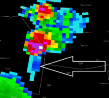
The bounded weak echo region, also known as a BWER or a vault, is a radar signature within a thunderstorm characterized by a local minimum in radar reflectivity at low levels which extends upward into, and is surrounded by, higher reflectivities aloft, forming a kind of dome of weak echoes. This feature is associated with a strong updraft and is almost always found in the inflow region of a thunderstorm: it cannot be seen visually. The BWER has been noted on radar imagery of severe thunderstorms since 1973 and has a lightning detection system equivalent known as a lightning hole.

<span class="mw-page-title-main">Graupel</span> Precipitation that forms when supercooled droplets of water freeze on a falling snowflake

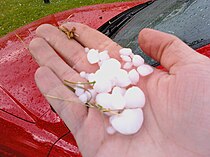
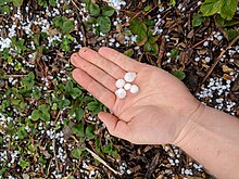
Graupel, also called soft hail, corn snow, hominy snow, or snow pellets, is precipitation that forms when supercooled water droplets in air are collected and freeze on falling snowflakes, forming 2–5 mm (0.08–0.20 in) balls of crisp, opaque rime.

<span class="mw-page-title-main">Air-mass thunderstorm</span> Thunderstorm that is generally weak and usually not severe

An air-mass thunderstorm, also called an "ordinary", "single cell", "isolated" or "garden variety" thunderstorm, is a thunderstorm that is generally weak and usually not severe. These storms form in environments where at least some amount of Convective Available Potential Energy (CAPE) is present, but with very low levels of wind shear and helicity. The lifting source, which is a crucial factor in thunderstorm development, is usually the result of uneven heating of the surface, though they can be induced by weather fronts and other low-level boundaries associated with wind convergence. The energy needed for these storms to form comes in the form of insolation, or solar radiation. Air-mass thunderstorms do not move quickly, last no longer than an hour, and have the threats of lightning, as well as showery light, moderate, or heavy rainfall. Heavy rainfall can interfere with microwave transmissions within the atmosphere.

<span class="mw-page-title-main">Severe weather</span> Any dangerous meteorological phenomenon

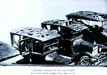
Severe weather is any dangerous meteorological phenomenon with the potential to cause damage, serious social disruption, or loss of human life. Types of severe weather phenomena vary, depending on the latitude, altitude, topography, and atmospheric conditions. High winds, hail, excessive precipitation, and wildfires are forms and effects of severe weather, as are thunderstorms, downbursts, tornadoes, waterspouts, tropical cyclones, and extratropical cyclones. Regional and seasonal severe weather phenomena include blizzards (snowstorms), ice storms, and duststorms.

<span class="mw-page-title-main">Atmospheric convection</span> Atmospheric phenomenon

Atmospheric convection is the result of a parcel-environment instability in the atmosphere. Different lapse rates within dry and moist air masses lead to instability. Mixing of air during the day expands the height of the planetary boundary layer, leading to increased winds, cumulus cloud development, and decreased surface dew points. Convection involving moist air masses leads to thunderstorm development, which is often responsible for severe weather throughout the world. Special threats from thunderstorms include hail, downbursts, and tornadoes.

Convective storm detection is the meteorological observation, and short-term prediction, of deep moist convection (DMC). DMC describes atmospheric conditions producing single or clusters of large vertical extension clouds ranging from cumulus congestus to cumulonimbus, the latter producing thunderstorms associated with lightning and thunder. Those two types of clouds can produce severe weather at the surface and aloft.

<span class="mw-page-title-main">1999 Sydney hailstorm</span> 1999 storm in Australia

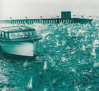
The 1999 Sydney hailstorm was the costliest natural disaster in Australian insurance history, causing extensive damage along the east coast of New South Wales. The storm developed south of Sydney on the afternoon of Wednesday, 14 April 1999, and struck the city's eastern suburbs, including the central business district, later that evening.

<span class="mw-page-title-main">1947 Sydney hailstorm</span> Natural disaster in Sydney, Australia

The 1947 Sydney hailstorm was a natural disaster which struck Sydney, Australia, on 1 January 1947. The storm cell developed on the morning of New Year's Day, a public holiday in Australia, over the Blue Mountains, hitting the city and dissipating east of Bondi in the mid-afternoon. At the time, it was the most severe storm to strike the city since recorded observations began in 1792.

<span class="mw-page-title-main">Outline of meteorology</span> Overview of and topical guide to meteorology

The following outline is provided as an overview of and topical guide to the field of Meteorology.

The Alberta Hail Project was a research project sponsored by the Alberta Research Council and Environment Canada to study hailstorm physics and dynamics in order to design and test means for suppressing hail. It ran from 1956 until 1985. The main instrument in this research was an S-band circularly polarized weather radar located at the Red Deer Industrial Airport in central Alberta, Canada.

<span class="mw-page-title-main">Glossary of meteorology</span> List of definitions of terms and concepts commonly used in meteorology

This glossary of meteorology is a list of terms and concepts relevant to meteorology and atmospheric science, their sub-disciplines, and related fields.

References

  1. 1 2 "hail". nationalgeographic.org. National Geographic Society. 21 January 2011. Archived from the original on 22 February 2021. Retrieved 14 January 2021.
  2. "What's the difference between hail, sleet, and freezing rain?". The Straight Dope . 1999-08-06. Archived from the original on 2014-02-02. Retrieved 2016-07-23.
  3. "hailstone". Merriam-Webster . Archived from the original on 2013-01-16. Retrieved 2013-01-23.
  4. 1 2 3 "Hail". Glossary of Meteorology. American Meteorological Society. 2009. Archived from the original on 2010-07-25. Retrieved 2009-07-15.
  5. "Hailstorm". Glossary of Meteorology. American Meteorological Society. 2009. Archived from the original on 2011-06-06. Retrieved 2009-08-29.
  6. "Aggregate hailstone". National Severe Storms Laboratory, National Oceanic and Atmospheric Administration. 2007-04-23. Archived from the original on 2009-08-10. Retrieved 2009-07-15.
  7. Jewell, Ryan; Brimelow, Julian (2004-08-17). "P9.5 Evaluation of an Alberta Hail Growth Model Using Severe Hail Proximity Soundings in the United States" (PDF). spc.noaa.gov. Archived (PDF) from the original on 2009-05-07. Retrieved 2009-07-15.
  8. "Severe Thunderstorm criteria". ec.gc.ca. Meteorological Service of Canada, Environment Canada. November 3, 2010. Archived from the original on August 5, 2012. Retrieved 2011-05-12.
  9. "NEW 1 Inch Hail Criteria". noaa.gov. US: National Weather Service, National Oceanic and Atmospheric Administration. January 4, 2010. Archived from the original on September 7, 2011. Retrieved 2011-05-12.
  10. "Hail..." Columbia, South Carolina: National Weather Service Forecast Office. 2009-01-27. Archived from the original on 2009-04-12. Retrieved 2009-08-28.
  11. "Forecasting Hail". theweatherprediction.com. Retrieved 2018-08-08.
  12. 1 2 3 "Hail". ncar.ucar.edu. National Center for Atmospheric Research, University Corporation for Atmospheric Research. 2008. Archived from the original on 2010-05-27. Retrieved 2009-07-18.
  13. 1 2 3 Nelson, Stephan P. (August 1983). "The Influence of Storm Flow Struce on Hail Growth". Journal of the Atmospheric Sciences. 40 (8): 1965–1983. Bibcode:1983JAtS...40.1965N. doi: 10.1175/1520-0469(1983)040<1965:TIOSFS>2.0.CO;2 . ISSN   1520-0469.
  14. Gallagher, Frank W. III (October 2000). "Distant Green Thunderstorms – Frazer's Theory Revisited". Journal of Applied Meteorology. American Meteorological Society. 39 (10): 1754. Bibcode:2000JApMe..39.1754G. doi: 10.1175/1520-0450-39.10.1754 .
  15. Brimelow, Julian C.; Reuter, Gerhard W.; Poolman, Eugene R. (2002). "Modeling Maximum Hail Size in Alberta Thunderstorms". Weather and Forecasting. 17 (5): 1048–1062. Bibcode:2002WtFor..17.1048B. doi: 10.1175/1520-0434(2002)017<1048:MMHSIA>2.0.CO;2 . ISSN   1520-0434.
  16. Rauber, Robert M.; Walsh, John E.; Charlevoix, Donna Jean (2012). Severe & Hazardous Weather. Kendall/Hunt Publishing Company. ISBN   978-0-7575-9772-5.
  17. Marshall, Jacque (2000-04-10). "Hail Fact Sheet". University Corporation for Atmospheric Research. Archived from the original on 2009-10-15. Retrieved 2009-07-15.
  18. 1 2 Wolf, Pete (2003-01-16). "Meso-Analyst Severe Weather Guide". University Corporation for Atmospheric Research. Archived from the original on 2003-03-20. Retrieved 2009-07-16.
  19. Downing, Thomas E.; Olsthoorn, Alexander A.; Tol, Richard S. J. (1999). Climate, change and risk. Routledge. pp. 41–43. ISBN   978-0-415-17031-4 . Retrieved 2009-07-16.
  20. "Flight Briefing Notes: Adverse Weather Operations Optimum Use of Weather Radar" (PDF). SKYbrary.aero. Airbus. 2007-03-14. p. 2. Archived from the original (PDF) on 2011-05-31. Retrieved 2009-11-19.
  21. Hand, W. H.; Cappelluti, G. (January 2011). "A global hail climatology using the UK Met Office convection diagnosis procedure (CDP) and model analyses". Meteorological Applications . Wiley. 18 (4): 446. Bibcode:2011MeApp..18..446H. doi: 10.1002/met.236 .
  22. "Where does severe weather occur?". Geoscience Australia, Commonwealth of Australia. 2007-09-04. Archived from the original on 2009-06-21. Retrieved 2009-08-28.
  23. 1 2 3 Oliver, John E. (2005). Encyclopedia of World Climatology. Springer. p. 401. ISBN   978-1-4020-3264-6 . Retrieved 2009-08-28.
  24. Liu, Dongxia; Feng, Guili; Wu, Shujun (February 2009). "The characteristics of cloud-to-ground lightning activity in hailstorms over northern China". Atmospheric Research. 91 (2–4): 459–465. Bibcode:2009AtmRe..91..459L. doi:10.1016/j.atmosres.2008.06.016.
  25. 1 2 Laviola, Sante; Monte, Giulio; Cattani, Elsa; Levizzani, Vincenzo (September 2022). "Hail Climatology in the Mediterranean Basin Using the GPM Constellation (19992021)". Remote Sensing. 14 (17): 4320. Bibcode:2022RemS...14.4320L. doi: 10.3390/rs14174320 . ISSN   2072-4292.
  26. Počakal, Damir; Večenaj, Željko; Štalec, Janez (July 2009). "Hail characteristics of different regions in continental part of Croatia based on influence of orography". Atmospheric Research. 93 (1–3): 516. Bibcode:2009AtmRe..93..516P. doi:10.1016/j.atmosres.2008.10.017.
  27. Munoz, Rene (2000-06-02). "Fact Sheet on Hail". University Corporation for Atmospheric Research. Archived from the original on 2009-10-15. Retrieved 2009-07-18.
  28. 1 2 3 Doesken, Nolan J. (April 1994). "Hail, Hail, Hail ! The Summertime Hazard of Eastern Colorado" (PDF). Colorado Climate. 17 (7). Archived from the original (PDF) on 2010-11-25. Retrieved 2009-07-18.
  29. Roeseler, Charles A.; Wood, Lance (2006-02-02). "VIL density and Associated Hail Size Along the Northwest Gulf Coast". National Weather Service Southern Region Headquarters. Archived from the original on August 18, 2007. Retrieved 2009-08-28.
  30. Aydin, K.; Seliga, T.A.; Balaji, V. (October 1986). "Remote Sensing of Hail with a Dual Linear Polarization Radar". Journal of Climate and Applied Meteorology. 25 (10): 1475–14. Bibcode:1986JApMe..25.1475A. doi: 10.1175/1520-0450(1986)025<1475:RSOHWA>2.0.CO;2 . ISSN   1520-0450.
  31. "Hail Signature Development". CHILL National Radar Facility, Colorado State University. 2007-08-22. Archived from the original on 2009-01-07. Retrieved 2009-08-28.
  32. "Hydrometeor classification example". CHILL National Radar Facility, Colorado State University. 2008-08-25. Archived from the original on 2010-06-24. Retrieved 2009-08-28.
  33. Bauer-Messmer, Bettina; Waldvogel, Albert (1998-07-25). "Satellite data based detection and prediction of hail". Atmospheric Research. 43 (3): 217. Bibcode:1997AtmRe..43..217B. doi:10.1016/S0169-8095(96)00032-4.
  34. "NeRAIN Data Site-Measuring Hail". Nebraska Rainfall Assessment Information Network, Nebraska Department of Natural Resources. 2009. Archived from the original on 2009-03-02. Retrieved 2009-08-29.
  35. "Hail Scale". torro.org.uk. The TORnado Storm Research Organization. 2009. Archived from the original on 2009-04-22. Retrieved 2009-08-28.
  36. "SA-METAR". Alaska Air Flight Service Station, Federal Aviation Administration. 2007-04-10. Archived from the original on May 1, 2008. Retrieved 2009-08-29.
  37. "Hail Basics". National Severe Storms Laboratory, National Oceanic and Atmospheric Administration. 2006-11-15. Archived from the original on 2009-05-06. Retrieved 2009-08-28.
  38. National Weather Service (July 26, 2021). "National Weather Service Instruction 10 - 1605" (PDF). Retrieved June 26, 2023.
  39. "World: Heaviest Hailstone". wmo.asu.edu. ASU World Meteorological Organization. Archived from the original on 2015-06-29. Retrieved 2016-07-23.
  40. 1 2 "Appendix I – Weather Extremes" (PDF). San Diego, California: National Weather Service. Archived from the original (PDF) on 28 May 2008. Retrieved 2010-06-01.
  41. "Record Setting Hail Event in Vivian, South Dakota on July 23, 2010". Aberdeen, South Dakota: National Weather Service. 30 July 2010. Archived from the original on 1 August 2010. Retrieved 2010-08-03.
  42. "Largest Hailstone in U.S. History Found". nationalgeographic.com. National Geographic. Archived from the original on 2010-04-20. Retrieved 2010-08-20.
  43. "What Places in the World Usually Have the Most Hail in One Year?". 2013-04-12. Archived from the original on 2017-10-17. Retrieved 2017-10-16.
  44. Glenday, Craig (2013). Guinness World Records 2014. Guinness World Records Limited. p.  22. ISBN   978-1-908843-15-9.
  45. "Hail Damage to Roofs". adjustersinternational.com. Adjusting Today. Archived from the original on 2015-10-16. Retrieved 2009-12-11.
  46. Field, P.R.; Hand, W.H.; Cappelluti, G.; et al. (November 2010). "Hail Threat Standardisation" (PDF). European Aviation Safety Agency. RP EASA.2008/5. Archived from the original (PDF) on 2013-12-07.
  47. "Hazards". aviationweather.ws. Federal Aviation Administration. 2009. Archived from the original on 2010-03-25. Retrieved 2009-08-29.
  48. Coppola, Damon P. (2007). Introduction to international disaster management. Butterworth-Heinemann. p. 62. ISBN   978-0-7506-7982-4.
  49. Orr, David (2004-11-07). "Giant hail killed more than 200 in Himalayas". Telegraph Group Unlimited via the Internet Wayback Machine. Archived from the original on 2005-12-03. Retrieved 2009-08-28.
  50. "Hail Climatology". National Severe Storms Laboratory, National Oceanic and Atmospheric Administration. 2006-10-09. Archived from the original on 2009-06-13. Retrieved 2009-08-29.
  51. Peters, Albert J. (2003-03-03). "Crop Hail Damage Assessment" (PDF). inria.fr. Institut National De Recherche En Informatique Et En Automatique. Archived from the original (PDF) on 2011-07-21. Retrieved 2009-08-28.
  52. Carmichael, Harold (2009-06-15). "Sudbury lashed by freak storm; hail pummels downtown core". Sudbury Star. Sun Media. Archived from the original on 2009-06-16. Retrieved 2009-08-28.
  53. Schlatter, Thomas W.; Doesken, Nolan (September 2010). "Deep Hail: Tracking an Elusive Phenomenon". Weatherwise. Taylor & Francis. 63 (5): 35–41. doi:10.1080/00431672.2010.503841. ISSN   0043-1672. S2CID   191481064 . Retrieved 2015-08-09.[ permanent dead link ]
  54. Rubino, Joe (2010-07-29). "Boulder County cleans up Nederland-area roadways after foot-deep hailstorm". Colorado Daily. Archived from the original on 2015-06-10. Retrieved 2014-12-20.
  55. Mitchell, Kirk (5 June 2015). "One Denver block buried under up to 4 feet of hail". The Denver Post. Archived from the original on 6 June 2015. Retrieved 7 June 2015.
  56. Kalina, E.; et al. (26 October 2015). "Colorado Plowable Hailstorms: Synoptic Weather, Radar and Lightning Characteristics". Weather and Forecasting. 31 (2): 663. Bibcode:2016WtFor..31..663K. doi: 10.1175/WAF-D-15-0037.1 .
  57. "Deep Hail Project – Report your hail depth!!". University of Colorado Boulder. Archived from the original on 2016-07-08. Retrieved 2016-06-14.
  58. Abshaev, M. T.; Abshaev, A. M.; Malkarova, A. M. (22–24 October 2007). "Radar Estimation of Physical Efficiency of Hail Suppression Projects". Antalya, Turkey: 9th WMO Scientific Conference on Weather Modification: 228–231.{{cite journal}}: Cite journal requires |journal= (help)
  59. Abshaev, M. T.; Abshaev, A. M.; Malkarova, A. M. (2012). "Estimation of antihail projects efficiency considering the tendency of hail climatology change". WWRP. Bali, Indonesia: 10th WMO Scientific Conference on Weather Modification. 2012–2: 1–4.
  60. Federer, B.; Waldvogel, A.; Schmid, W.; et al. (1986-07-07). "Main Results of Grossversuch IV". Journal of Climate and Applied Meteorology . 25 (7): 917–957. Bibcode:1986JApMe..25..917F. doi: 10.1175/1520-0450(1986)025<0917:MROGI>2.0.CO;2 . JSTOR   26182470.

Further reading