Flash flood

Last updated
An underpass in Charlottesville, Virginia, United States. during normal conditions (upper) and after fifteen minutes of heavy rain (lower) Main and University, Charlottesville, during flash flood (comparison).jpg
An underpass in Charlottesville, Virginia, United States. during normal conditions (upper) and after fifteen minutes of heavy rain (lower)
Driving through a flash-flooded road Driving through flash flood.jpg
Driving through a flash-flooded road
A flash flood after a thunderstorm in the Gobi, Mongolia GobiFlood.JPG
A flash flood after a thunderstorm in the Gobi, Mongolia

A flash flood is a rapid flooding of low-lying areas: washes, rivers, dry lakes and depressions. It may be caused by heavy rain associated with a severe thunderstorm, hurricane, or tropical storm, or by meltwater from ice or snow flowing over ice sheets or snowfields. Flash floods may also occur after the collapse of a natural ice or debris dam, or a human structure such as a man-made dam, as occurred before the Johnstown Flood of 1889. Flash floods are distinguished from regular floods by having a timescale of fewer than six hours between rainfall and the onset of flooding. [1]

Contents

Flash floods are a significant hazard, causing more fatalities in the U.S. in an average year than lightning, tornadoes, or hurricanes. Flash floods can also deposit large quantities of sediments on floodplains and can be destructive of vegetation cover not adapted to frequent flood conditions.

Causes

Flash flooded road in Northern Mexico, after a 3-5 hour long thunderstorm that occurred during a drought that lasted nearly 1 year Minor Flood.jpg
Flash flooded road in Northern Mexico, after a 3–5 hour long thunderstorm that occurred during a drought that lasted nearly 1 year

Flash floods most often occur in dry areas that have recently received precipitation, but they may be seen anywhere downstream from the source of the precipitation, even many miles from the source. In areas on or near volcanoes, flash floods have also occurred after eruptions, when glaciers have been melted by the intense heat. Flash floods are known to occur in the highest mountain ranges of the United States and are also common in the arid plains of the Southwestern United States. Flash flooding can also be caused by extensive rainfall released by hurricanes and other tropical storms, as well as the sudden thawing effect of ice dams. [2] [3] Human activities can also cause flash floods to occur. When dams fail, a large quantity of water can be released and destroy everything in its path. [3]

Hazards

A flash flood greatly inundates a small ditch, flooding barns and ripping out newly installed drain pipes. Canandaigua flood July 23, 2017 barn flooded 4.jpg
A flash flood greatly inundates a small ditch, flooding barns and ripping out newly installed drain pipes.

The United States National Weather Service gives the advice "Turn Around, Don't Drown" for flash floods; that is, it recommends that people get out of the area of a flash flood, rather than trying to cross it. Many people tend to underestimate the dangers of flash floods. What makes flash floods most dangerous is their sudden nature and fast-moving water. A vehicle provides little to no protection against being swept away; it may make people overconfident and less likely to avoid the flash flood. More than half of the fatalities attributed to flash floods are people swept away in vehicles when trying to cross flooded intersections. [4] As little as 2 feet (0.61 m) of water is enough to carry away most SUV-sized vehicles. [5] The U.S. National Weather Service reported in 2005 that, using a national 30-year average, more people die yearly in floods, 127 on average, than by lightning (73), tornadoes (65), or hurricanes (16). [6]

Flash flood running into a canyon in the Negev, Israel Ein Avdat Flood 1.JPG
Flash flood running into a canyon in the Negev, Israel

In deserts, flash floods can be particularly deadly for several reasons. First, storms in arid regions are infrequent, but they can deliver an enormous amount of water in a very short time. Second, these rains often fall on poorly absorbent and often clay-like soil, which greatly increases the amount of runoff that rivers and other water channels have to handle. [7] These regions tend not to have the infrastructure that wetter regions have to divert water from structures and roads, such as storm drains, culverts, and retention basins, either because of sparse population or poverty, or because residents believe the risk of flash floods is not high enough to justify the expense. In fact, in some areas, desert roads frequently cross a dry river and creek beds without bridges. From the driver's perspective, there may be clear weather, when a river unexpectedly forms ahead of or around the vehicle in a matter of seconds. [8] Finally, the lack of regular rain to clear water channels may cause flash floods in deserts to be headed by large amounts of debris, such as rocks, branches, and logs. [9]

Deep slot canyons can be especially dangerous to hikers as they may be flooded by a storm that occurs on a mesa miles away. The flood sweeps through the canyon; the canyon makes it difficult to climb up and out of the way to avoid the flood. For example, a cloudburst in southern Utah on 14 September 2015 resulted in 20 flash flood fatalities, of which seven fatalities occurred at Zion National Park when hikers were trapped by floodwaters in a slot canyon. [10]

Flash flood impacts

Flash floods induce severe impacts in both the built and the natural environment. The effects of flash floods can be catastrophic and show extensive diversity, ranging from damages in buildings and infrastructure to impacts on vegetation, human lives and livestock. The effects are particularly difficult to characterize in urban areas. [11]

Researchers have used datasets such as the Severe Hazards Analysis and Verification Experiment (SHAVE) and the U.S. National Weather Service (NWS) Storm Data datasets to connect the impact of flash floods with the physical processes involved in flash flooding. This should increase the reliability of flash flood impact forecasting models. [12] Analysis of flash floods in the United States between 2006 and 2012 shows that injuries and fatalities are most likely in small, rural catchments, that the shortest events are also the most dangerous, that the hazards are greatest after nightfall, and that a very high fraction of injuries and fatalities involve vehicles. [13]

An impact severity scale is proposed in 2020 providing a coherent overview of the flash flood effects through the classification of impact types and severity and mapping their spatial extent in a continuous way across the floodplain. Depending on the affected elements, the flood effects are grouped into 4 categories: (i) impacts on built environment (ii) impacts on man-made mobile objects,(iii) impacts on the natural environment (including vegetation, agriculture, geomorphology, and pollution) and (iv) impacts on the human population (entrapments, injuries, fatalities). The scale was proposed as a tool on prevention planning, as the resulting maps offer insights on future impacts, highlighting the high severity areas. [11]

Flash floods can cause rapid soil erosion. [14] Much of the Nile delta sedimentation may come from flash flooding in the desert areas that drain into the Nile River. [15] However, flash floods of short duration produce relatively little bedrock erosion or channel widening, having their greatest impact from sedimentation on the floodplain. [16]

Some wetlands plants, such as certain varieties of rice, are adapted to endure flash flooding. [17] However, plants that thrive in drier areas can be harmed by flooding, as the plants can become stressed by the large amount of water. [18] [19]

See also

Related Research Articles

<span class="mw-page-title-main">Erosion</span> Natural processes that remove soil and rock

Erosion is the action of surface processes that removes soil, rock, or dissolved material from one location on the Earth's crust and then transports it to another location where it is deposited. Erosion is distinct from weathering which involves no movement. Removal of rock or soil as clastic sediment is referred to as physical or mechanical erosion; this contrasts with chemical erosion, where soil or rock material is removed from an area by dissolution. Eroded sediment or solutes may be transported just a few millimetres, or for thousands of kilometres.

<span class="mw-page-title-main">Geography of Zimbabwe</span> Geographical features of Zimbabwe

Zimbabwe is a landlocked country in southern Africa lying north of the Tropic of Capricorn. During summer, the whole country experiences warm temperatures as a result of the sun being directly overhead. It straddles an extensive high inland plateau that drops northwards to the Zambezi valley where the border with Zambia is and similarly drops southwards to the Limpopo valley and the border with South Africa.

<span class="mw-page-title-main">Landslide</span> Natural hazard involving ground movement

Landslides, also known as landslips, are several forms of mass wasting that may include a wide range of ground movements, such as rockfalls, mudflows, shallow or deep-seated slope failures and debris flows. Landslides occur in a variety of environments, characterized by either steep or gentle slope gradients, from mountain ranges to coastal cliffs or even underwater, in which case they are called submarine landslides.

<span class="mw-page-title-main">Drought</span> Period with less precipitation than normal

A drought is a period of drier-than-normal conditions. A drought can last for days, months or years. Drought often has large impacts on the ecosystems and agriculture of affected regions, and causes harm to the local economy. Annual dry seasons in the tropics significantly increase the chances of a drought developing, with subsequent increased wildfire risks. Heat waves can significantly worsen drought conditions by increasing evapotranspiration. This dries out forests and other vegetation, and increases the amount of fuel for wildfires.

<span class="mw-page-title-main">Flood</span> Water overflow submerging usually-dry land

A flood is an overflow of water that submerges land that is usually dry. In the sense of "flowing water", the word may also be applied to the inflow of the tide. Floods are of significant concern in agriculture, civil engineering and public health. Human changes to the environment often increase the intensity and frequency of flooding. Examples for human changes are land use changes such as deforestation and removal of wetlands, changes in waterway course or flood controls such as with levees. Global environmental issues also influence causes of floods, namely climate change which causes an intensification of the water cycle and sea level rise. For example, climate change makes extreme weather events more frequent and stronger. This leads to more intense floods and increased flood risk.

<span class="mw-page-title-main">Thunderstorm</span> Storm characterized by lightning and thunder

A thunderstorm, also known as an electrical storm or a lightning storm, is a storm characterized by the presence of lightning and its acoustic effect on the Earth's atmosphere, known as thunder. Relatively weak thunderstorms are sometimes called thundershowers. Thunderstorms occur in a type of cloud known as a cumulonimbus. They are usually accompanied by strong winds and often produce heavy rain and sometimes snow, sleet, or hail, but some thunderstorms produce little precipitation or no precipitation at all. Thunderstorms may line up in a series or become a rainband, known as a squall line. Strong or severe thunderstorms include some of the most dangerous weather phenomena, including large hail, strong winds, and tornadoes. Some of the most persistent severe thunderstorms, known as supercells, rotate as do cyclones. While most thunderstorms move with the mean wind flow through the layer of the troposphere that they occupy, vertical wind shear sometimes causes a deviation in their course at a right angle to the wind shear direction.

<span class="mw-page-title-main">Alluvial fan</span> Fan-shaped deposit of sediment

An alluvial fan is an accumulation of sediments that fans outwards from a concentrated source of sediments, such as a narrow canyon emerging from an escarpment. They are characteristic of mountainous terrain in arid to semiarid climates, but are also found in more humid environments subject to intense rainfall and in areas of modern glaciation. They range in area from less than 1 square kilometer (0.4 sq mi) to almost 20,000 square kilometers (7,700 sq mi).

<span class="mw-page-title-main">Wadi</span> River valley, especially a dry riverbed that contains water only during times of heavy rain

Wadi, alternatively wād, Maghrebi Arabic Oued, Hebrew: וָאדִי, romanized: wadi, lit. 'wadi') is the Arabic term traditionally referring to a river valley. In some instances, it may refer to a wet (ephemeral) riverbed that contains water only when heavy rain occurs.

<span class="mw-page-title-main">Arroyo (watercourse)</span> Dry watercourse with flow after rain

An arroyo, from Spanish arroyo, also called a wash, is a dry watercourse that temporarily or seasonally fills and flows after sufficient rain. Flash floods are common in arroyos following thunderstorms.

<span class="mw-page-title-main">Ciénega</span> Wetland system unique to the American Southwest

A ciénega is a wetland system unique to the American Southwest and Northern Mexico. Ciénagas are alkaline, freshwater, spongy, wet meadows with shallow-gradient, permanently saturated soils in otherwise arid landscapes that often occupy nearly the entire widths of valley bottoms. That description satisfies historic, pre-damaged ciénagas, although few can be described that way now. Incised ciénagas are common today. Ciénagas are usually associated with seeps or springs, found in canyon headwaters or along margins of streams. Ciénagas often occur because the geomorphology forces water to the surface, over large areas, not merely through a single pool or channel. In a healthy ciénaga, water slowly migrates through long, wide-scale mats of thick, sponge-like wetland sod. Ciénaga soils are squishy, permanently saturated, highly organic, black in color or anaerobic. Highly adapted sedges, rushes and reeds are the dominant plants, with succession plants—Goodding's willow, Fremont cottonwoods and scattered Arizona walnuts—found on drier margins, down-valley in healthy ciénagas where water goes underground or along the banks of incised ciénagas.

<span class="mw-page-title-main">Surface runoff</span> Flow of excess rainwater not infiltrating in the ground over its surface

Surface runoff is the unconfined flow of water over the ground surface, in contrast to channel runoff. It occurs when excess rainwater, stormwater, meltwater, or other sources, can no longer sufficiently rapidly infiltrate in the soil. This can occur when the soil is saturated by water to its full capacity, and the rain arrives more quickly than the soil can absorb it. Surface runoff often occurs because impervious areas do not allow water to soak into the ground. Furthermore, runoff can occur either through natural or human-made processes.

<span class="mw-page-title-main">Severe weather</span> Any dangerous meteorological phenomenon

Severe weather is any dangerous meteorological phenomenon with the potential to cause damage, serious social disruption, or loss of human life. Types of severe weather phenomena vary, depending on the latitude, altitude, topography, and atmospheric conditions. High winds, hail, excessive precipitation, and wildfires are forms and effects of severe weather, as are thunderstorms, downbursts, tornadoes, waterspouts, tropical cyclones, and extratropical cyclones. Regional and seasonal severe weather phenomena include blizzards (snowstorms), ice storms, and duststorms.

<span class="mw-page-title-main">Pediment (geology)</span> Very gently sloping inclined bedrock surface

A pediment, also known as a concave slope or waning slope, is a very gently sloping (0.5°–7°) inclined bedrock surface. It is typically a concave surface sloping down from the base of a steeper retreating desert cliff, escarpment, or surrounding a monadnock or inselberg, but may persist after the higher terrain has eroded away.

<span class="mw-page-title-main">Flood control</span> Methods used to reduce or prevent the detrimental effects of flood waters

Flood control methods are used to reduce or prevent the detrimental effects of flood waters. Flooding can be caused by a mix of both natural processes, such as extreme weather upstream, and human changes to waterbodies and runoff. Flood control methods can be either of the structural type and of the non-structural type. Structural methods hold back floodwaters physically, while non-structural methods do not. Building hard infrastructure to prevent flooding, such as flood walls, is effective at managing flooding. However, best practice within landscape engineering is more and more to rely on soft infrastructure and natural systems, such as marshes and flood plains, for handling the increase in water.

In 2016, deadly floods hit Ethiopia, leaving at least 200 people dead and over 200,000 people homeless as seasonal rains come early to the country. The majority of these deaths occurred in the city of Jijiga while elsewhere, heavy downpours of rain were reported with more floods expected in the next few days. The floods are reportedly at higher levels than other flood travesties than that of previous years.

<span class="mw-page-title-main">May Gabat</span> River in the Tigray highlands of Ethiopia

The May Gabat is a river of northern Ethiopia. Rising in the mountains of Inderta, it flows westward to Giba River which empties finally in the Tekezé River. The Gereb Segen reservoir has been built on this river in 2016, mainly for providing Mekelle with potable water.

<span class="mw-page-title-main">Agula'i River</span> River in the Tigray highlands of Ethiopia

The Agula’i is a river of northern Ethiopia. Rising in the mountains of Atsbi Wenberta, it flows southwestward to Giba River which empties finally in the Tekezé River. Future Lake Giba will occupy the plain where Sulluh, Genfel and Agula’i Rivers meet.

<span class="mw-page-title-main">Climate change in Texas</span> Climate change in the US state of Texas

The climate in Texas is changing partially due to global warming and rising trends in greenhouse gas emissions. As of 2016, most area of Texas had already warmed by 1.5 °F (0.83 °C) since the previous century because of greenhouse gas emissions by the United States and other countries. Texas is expected to experience a wide range of environmental impacts from climate change in the United States, including rising sea levels, more frequent extreme weather events, and increasing pressure on water resources.

<span class="mw-page-title-main">Loess Plateau</span> Plateau in north/northwest China

The Chinese Loess Plateau, or simply the Loess Plateau, is a plateau in north-central China formed of loess, a clastic silt-like sediment formed by the accumulation of wind-blown dust. It is located southeast of the Gobi Desert and is surrounded by the Yellow River. It includes parts of the Chinese provinces of Gansu, Shaanxi and Shanxi. The depositional setting of the Chinese Loess Plateau was shaped by the tectonic movement in the Neogene period, after which strong southeast winds caused by the East Asian Monsoon transported sediment to the plateau during the Quaternary period. The three main morphological types in the Loess Plateau are loess platforms, ridges and hills, formed by the deposition and erosion of loess. Most of the loess comes from the Gobi Desert and other nearby deserts. The sediments were transported to the Loess Plateau during interglacial periods by southeasterly prevailing winds and winter monsoon winds. After the deposition of sediments on the plateau, they were gradually compacted to form loess under the arid climate.

<span class="mw-page-title-main">Urban flooding</span> Management of flood events in cities and surrounding areas

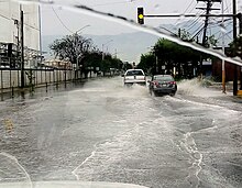
Urban flooding is the inundation of land or property in cities or other built environment, caused by rainfall overwhelming the capacity of drainage systems, such as storm sewers. Urban flooding can happen regardless of whether or not affected communities are located within designated floodplains or near any body of water. It is triggered for example by an overflow of rivers and lakes, flash flooding or snowmelt. During the flood, stormwater or water released from damaged water mains may accumulate on property and in public rights-of-way. It can seep through building walls and floors, or backup into buildings through sewer pipes, cellars, toilets and sinks.

References

  1. "Flash Flooding Definition". National Weather Service. Archived from the original on September 1, 2017. Retrieved August 31, 2017.
  2. WeatherEye (2007). "Flash Flood!". Sinclair Acquisition IV, Inc. Archived from the original on 2009-02-27. Retrieved 2009-09-09.
  3. 1 2 National Weather Service Forecast Office Morristown, Tennessee (2006-03-07). "Definitions of flood and flash flood". National Weather Service Southern Region Headquarters. Archived from the original on 2006-09-29. Retrieved 2009-09-09.
  4. "Watches, Warnings & Advisories—Flash Flood Warning". National Weather Service. Archived from the original on 2008-01-11. Retrieved 2007-06-25.
  5. "A Preparedness Guide to flash floods #1 weather-related killer in the United States". U.S. Department of Commerce, National Oceanic and Atmospheric Administration National Weather Service, Federal Emergency Management Agency, American Red Cross. July 1992. Archived from the original on 2007-07-05. Retrieved 2007-06-25.
  6. "Turn Around Don't Drown". Archived from the original on 2018-11-29. Retrieved 2007-06-25.
  7. Campos, Priscila Celebrini de Oliveira; Paz, Igor (2020). "Spatial Diagnosis of Rain Gauges' Distribution and Flood Impacts: Case Study in Itaperuna, Rio de Janeiro—Brazil". Water. 12 (4): 1120. doi: 10.3390/w12041120 .
  8. McGuire, Thomas (2004). "Weather Hazards and the Changing Atmosphere" (PDF). Earth Science: The Physical Setting. Amsco School Pubns Inc. p. 571. ISBN   0-87720-196-X. Archived from the original (PDF) on 2008-06-25. Retrieved 2008-07-17.
  9. Jahns, R.H. (1949). "Desert floods" (PDF). Engineering and Science. 12 (8): 10–14. Archived (PDF) from the original on 30 April 2021. Retrieved 17 July 2021.
  10. Smith, James A.; Baeck, Mary Lynn; Yang, Long; Signell, Julia; Morin, Efrat; Goodrich, David C. (December 2019). "The Paroxysmal Precipitation of the Desert: Flash Floods in the Southwestern United States". Water Resources Research. 55 (12): 10218–10247. Bibcode:2019WRR....5510218S. doi: 10.1029/2019WR025480 .
  11. 1 2 Diakakis M.; Deligiannakis G.; Antoniadis Z.; Melaki M.; Katsetsiadou K.N.; Andreadakis E.; Spyrou N.I. & Gogou M. (2020). "Proposal of a flash flood impact severity scale for the classification and mapping of flash flood impacts". Journal of Hydrology. 590: 125452. Bibcode:2020JHyd..59025452D. doi:10.1016/j.jhydrol.2020.125452. S2CID   225031085.
  12. Calianno, Martin; Ruin, Isabelle; Gourley, Jonathan J. (January 2013). "Supplementing flash flood reports with impact classifications". Journal of Hydrology. 477: 1–16. Bibcode:2013JHyd..477....1C. doi:10.1016/j.jhydrol.2012.09.036.
  13. Špitalar, Maruša; Gourley, Jonathan J.; Lutoff, Celine; Kirstetter, Pierre-Emmanuel; Brilly, Mitja; Carr, Nicholas (November 2014). "Analysis of flash flood parameters and human impacts in the US from 2006 to 2012". Journal of Hydrology. 519: 863–870. Bibcode:2014JHyd..519..863S. doi:10.1016/j.jhydrol.2014.07.004.
  14. Brilly, Mitja (2001). "The Integrated Approach to Flash Flood Management". Coping with Flash Floods. pp. 103–113. doi:10.1007/978-94-010-0918-8_12. ISBN   978-0-7923-6826-7.
  15. Labib, Tarik M. (September 1981). "Soil erosion and total denudation due to flash floods in the Egyptian eastern desert". Journal of Arid Environments. 4 (3): 191–202. Bibcode:1981JArEn...4..191L. doi:10.1016/S0140-1963(18)31560-X.
  16. Marchi, Lorenzo; Cavalli, Marco; Amponsah, William; Borga, Marco; Crema, Stefano (November 2016). "Upper limits of flash flood stream power in Europe". Geomorphology. 272: 68–77. Bibcode:2016Geomo.272...68M. doi:10.1016/j.geomorph.2015.11.005.
  17. Hattori, Yoko; Nagai, Keisuke; Ashikari, Motoyuki (February 2011). "Rice growth adapting to deepwater". Current Opinion in Plant Biology. 14 (1): 100–105. Bibcode:2011COPB...14..100H. doi:10.1016/j.pbi.2010.09.008. PMID   20934370.
  18. Perata, Pierdomenico; Armstrong, William; Voesenek, Laurentius A. C. J. (April 2011). "Plants and flooding stress: Commentary". New Phytologist. 190 (2): 269–273. doi: 10.1111/j.1469-8137.2011.03702.x . hdl: 11382/308967 . PMID   21443603.
  19. Tamang, Bishal; Fukao, Takeshi (17 December 2015). "Plant Adaptation to Multiple Stresses during Submergence and Following Desubmergence". International Journal of Molecular Sciences. 16 (12): 30164–30180. doi: 10.3390/ijms161226226 . PMC   4691168 . PMID   26694376.

Further reading