
A waterfall is an area where water flows over a vertical drop or a series of steep drops in the course of a stream or river. Waterfalls also occur where meltwater drops over the edge of a tabular iceberg or ice shelf.
Landforms are categorized by characteristic physical attributes such as their creating process, shape, elevation, slope, orientation, rock exposure, and soil type.
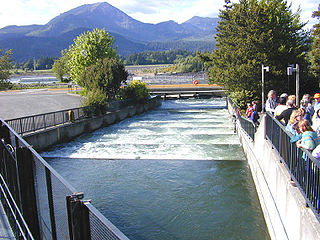
A fish ladder, also known as a fishway, fish pass or fish steps, is a structure on or around artificial and natural barriers to facilitate diadromous fishes' natural migration as well as movements of potamodromous species. Most fishways enable fish to pass around the barriers by swimming and leaping up a series of relatively low steps into the waters on the other side. The velocity of water falling over the steps has to be great enough to attract the fish to the ladder, but it cannot be so great that it washes fish back downstream or exhausts them to the point of inability to continue their journey upriver.

In geography and fluvial geomorphology, a thalweg or talweg is the line of lowest elevation within a valley or watercourse.

Breakwaters are structures constructed near the coasts as part of coastal management or to protect an anchorage from the effects of both weather and longshore drift.

A spillway is a structure used to provide the controlled release of water from a dam or levee downstream, typically into the riverbed of the dammed river itself. In the United Kingdom, they may be known as overflow channels. Spillways ensure that water does not damage parts of the structure not designed to convey water.

A culvert is a structure that allows water to flow under a road, railroad, trail, or similar obstruction from one side to the other. Typically embedded so as to be surrounded by soil, a culvert may be made from a pipe, reinforced concrete or other material. In the United Kingdom, the word can also be used for a longer artificially buried watercourse.

In stream restoration, river engineering or coastal engineering, revetments are sloping structures placed on banks or cliffs in such a way as to absorb the energy of incoming water. In military engineering they are structures, again sloped, formed to secure an area from artillery, bombing, or stored explosives. River or coastal revetments are usually built to preserve the existing uses of the shoreline and to protect the slope, as defense against erosion.

A gabion is a cage, cylinder or box filled with rocks, concrete, or sometimes sand and soil for use in civil engineering, road building, military applications and landscaping.

In architecture, a starling or, more commonly, cutwater is a defensive bulwark, usually built with pilings or bricks, surrounding the supports of a bridge or similar construction. Starlings may be shaped to ease the flow of the water around the bridge, reducing the damage caused by erosion or collisions with flood-borne debris, and may also form an important part of the structure of the bridge, spreading the weight of the piers. Shaping of the bulwark can render the current of water less forceful and/or better protect against erosion or other damage; the term cutwater especially applies for bulwarks that are relatively effective in that way. A starkwater is a bulwark specifically against ice damage.

River engineering is the process of planned human intervention in the course, characteristics, or flow of a river with the intention of producing some defined benefit. People have intervened in the natural course and behaviour of rivers since before recorded history—to manage the water resources, to protect against flooding, or to make passage along or across rivers easier. From Roman times, rivers have been used as a source of hydropower. From the late 20th century, river engineering has had environmental concerns broader than immediate human benefit and some river engineering projects have been concerned exclusively with the restoration or protection of natural characteristics and habitats.
Regarding the civil engineering of shorelines, soft engineering is a shoreline management practice that uses sustainable ecological principles to restore shoreline stabilization and protect riparian habitats. Soft Shoreline Engineering (SSE) uses the strategic placement of organic materials such as vegetation, stones, sand, debris, and other structural materials to reduce erosion, enhance shoreline aesthetic, soften the land-water interface, and lower costs of ecological restoration.

San Juan Creek, also called the San Juan River, is a 29-mile (47 km) long stream in Orange and Riverside Counties, draining a watershed of 133.9 square miles (347 km2). Its mainstem begins in the southern Santa Ana Mountains in the Cleveland National Forest. It winds west and south through San Juan Canyon, and is joined by Arroyo Trabuco as it passes through San Juan Capistrano. It flows into the Pacific Ocean at Doheny State Beach. San Juan Canyon provides a major part of the route for California State Route 74.

In geomorphology, drainage systems, also known as river systems, are the patterns formed by the streams, rivers, and lakes in a particular drainage basin. They are governed by the topography of the land, whether a particular region is dominated by hard or soft rocks, and the gradient of the land. Geomorphologists and hydrologists often view streams as part of drainage basins. This is the topographic region from which a stream receives runoff, throughflow, and its saturated equivalent, groundwater flow. The number, size, and shape of the drainage basins varies and the larger and more detailed the topographic map, the more information is available.

The Dickerson Whitewater Course, on the Potomac River near Dickerson, Maryland, was built for use by canoe and kayak paddlers training for the 1992 Olympic Games in Spain. It was the first pump-powered artificial whitewater course built in North America, and is still the only one anywhere with heated water. It remains an active training center for whitewater slalom racing, swiftwater rescue training, and other whitewater activities.

A river is a natural flowing watercourse, usually freshwater, flowing towards an ocean, sea, lake or another river. In some cases, a river flows into the ground and becomes dry at the end of its course without reaching another body of water. Small rivers can be referred to using names such as stream, creek, brook, rivulet, and rill. There are no official definitions for the generic term river as applied to geographic features, although in some countries or communities a stream is defined by its size. Many names for small rivers are specific to geographic location; examples are "run" in some parts of the United States, "burn" in Scotland and northeast England, and "beck" in northern England. Sometimes a river is defined as being larger than a creek, but not always: the language is vague.

A check dam is a small, sometimes temporary, dam constructed across a swale, drainage ditch, or waterway to counteract erosion by reducing water flow velocity. Check dams themselves are not a type of new technology; rather, they are an ancient technique dating from the second century A.D. Check dams are typically, though not always, implemented in a system of several dams situated at regular intervals across the area of interest.

A stepped spillway is a spillway with steps on the spillway chute to assist in the dissipation of the kinetic energy of the descending water. This eliminates or reduces the need for an additional energy dissipator, such as a body of water, at the end of the spillway downstream.
Open channel spillways are dam spillways that utilize the principles of open-channel flow to convey impounded water in order to prevent dam failure. They can function as principal spillways, emergency spillways, or both. They can be located on the dam itself or on a natural grade in the vicinity of the dam.

In February 2017, Oroville Dam's main and emergency spillways were damaged, prompting the evacuation of more than 180,000 people living downstream along the Feather River and the relocation of a fish hatchery.


