Daviess County, Missouri

Last updated

Daviess County
Daviess-courthouse cropped.jpg
Daviess County Courthouse in Gallatin
Map of Missouri highlighting Daviess County.svg
Location within the U.S. state of Missouri
Missouri in United States.svg
Missouri's location within the U.S.
Coordinates: 39°58′N93°59′W / 39.96°N 93.99°W / 39.96; -93.99
CountryFlag of the United States.svg United States
StateFlag of Missouri.svg  Missouri
FoundedDecember 29, 1836
Named for Major Joseph Hamilton Daviess
Seat Gallatin
Largest cityGallatin
Area
  Total569 sq mi (1,470 km2)
  Land563 sq mi (1,460 km2)
  Water5.8 sq mi (15 km2)  1.0%
Population
 (2020)
  Total8,430
  Estimate 
(2021) [1]
8,399
  Density15/sq mi (5.7/km2)
Time zone UTC−6 (Central)
  Summer (DST) UTC−5 (CDT)
Congressional district 6th
Website https://www.daviesscountymo.gov

Daviess County is a county located in the U.S. state of Missouri. As of the 2020 census, the population was 8,430. [2] Its county seat is Gallatin. [3] The county was organized December 29, 1836, from Ray County and named for Major Joseph Hamilton Daveiss, a soldier from Kentucky who was killed in 1811 at the Battle of Tippecanoe. [4]

Contents

The county includes the town of Jamesport, which has the largest Amish community in Missouri.

History

According to Latter Day Saint movement founder Joseph Smith, Adam-ondi-Ahman, situated in the central part of the county, was where Adam and Eve relocated after being banished from the Garden of Eden. According to LDS tradition, the site is to be a gathering spot prior to the Second Coming of Jesus Christ.

In 1838, two years after the county was organized, Joseph Smith's claims about the history of the area spurred in an influx of Mormon settlers. Non-Mormon residents feared they were going to lose control of the county and attempted to prevent Mormons from voting in the Gallatin Election Day Battle. This was to be the first skirmish in the Mormon War. Later, in retaliation for violence to their families and destruction of their property, some Mormons burned and sacked Gallatin, Grindstone Fork, Millport and other smaller settlements. The plundered goods were deposited in the Bishop's storehouse at Diahman. [5] Millport, which at the time was the largest city in the county and the center for trade, never recovered, and became a ghost town. [6] Missouri Governor Lilburn Boggs issued an Extermination Order to drive the Mormons from the state after arresting Joseph Smith and other leaders of the church.

Daviess County played a major role in the history of the outlaw James-Younger Gang. The first confirmed bank robbery involving Jesse James occurred on December 7, 1869, at the Daviess County Savings Association in Gallatin. John W. Sheets, the bank cashier, was killed in the process by Jesse James, who believed Sheets was Samuel P. Cox, who had killed James's bushwhacker colleague Bloody Bill Anderson during the American Civil War. On July 15, 1881, the gang was believed to have been responsible for the robbery of the Rock Island Line at Winston in which a conductor and passenger were killed.

After Jesse James was murdered in St. Joseph, Frank James surrendered in 1882 to face Daviess County charges in connection with the train robbery/murder as well as murder charges in the 1869 bank robbery. Frank James was tried from August 20 – September 6, 1883. Interest was so intense that the trial was moved to the Gallatin Opera House to accommodate the crowds. James was found not guilty of involvement in both crimes. Charges were made that the jury was filled with Southern sympathizers who refused to convict one of their own. [7]

The Daviess County Savings Association and the Gallatin Opera House have since been torn down, although the Winston Rock Island Line train station still stands and is operated by the local historical society as a museum.

Daviess County has one of only three Rotary Jails still in existence. Also known as the "Squirrel Cage Jail," [8] it is now a museum and is on the National Register of Historic Places.

Geography

According to the U.S. Census Bureau, the county has a total area of 569 square miles (1,470 km2), of which 563 square miles (1,460 km2) is land and 5.8 square miles (15 km2) (1.0%) is water. [9]

Adjacent counties

Major highways

Demographics

Historical population
CensusPop.Note
1840 2,736
1850 5,29893.6%
1860 9,60681.3%
1870 14,41050.0%
1880 19,14532.9%
1890 20,4566.8%
1900 21,3254.2%
1910 17,605−17.4%
1920 16,641−5.5%
1930 14,424−13.3%
1940 13,398−7.1%
1950 11,180−16.6%
1960 9,502−15.0%
1970 8,420−11.4%
1980 8,9055.8%
1990 7,865−11.7%
2000 8,0161.9%
2010 8,4335.2%
2020 8,4300.0%
2021 (est.)8,399 [10] −0.4%
U.S. Decennial Census [11]
1790-1960 [12] 1900-1990 [13]
1990-2000 [14] 2010-2020 [2]

As of the 2010 census, [15] there were 8,433 people, 3,214 households, and 2,489 families residing in the county. The population density was 15 people per square mile (5.8 people/km2). There were 4,199 housing units at an average density of 7 units per square mile (2.7/km2). The racial makeup of the county was 98.02% White, 0.27% Black or African American, 0.38% Native American, 0.06% Asian, 0.02% Pacific Islander, 0.08% from other races, and 1.16% from two or more races. Approximately 1.03% of the population were Hispanic or Latino of any race.

There were 3,214 households, out of which 31.92% had children under the age of 18 living with them, 58.81% were married couples living together, 8.06% had a female householder with no husband present, and 28.34% were non-families. 24.64% of all households were made up of individuals, and 10.89% had someone living alone who was 65 years of age or older. The average household size was 2.58 and the average family size was 3.06.

In the county, the population was spread out, with 26.70% under the age of 18, 7.02% from 18 to 24, 21.81% from 25 to 44, 27.38% from 45 to 64, and 17.09% who were 65 years of age or older. The median age was 40 years. For every 100 females there were 98.80 males. For every 100 females age 18 and over, there were 98.30 males.

The median income for a household in the county was $39,925, and the median income for a family was $48,839. Males had a median income of $33,882 versus $28,891 for females. The per capita income for the county was $19,900. About 9.80% of families and 13.80% of the population were below the poverty line, including 18.50% of those under age 18 and 11.60% of those age 65 or over.

Religion

Religion in Daviess County,according to ARDA (2020) [16]

  Evangelicals Churches (32.4%)
  Mainline Protestants Churches (12.7%)
  Anabaptist Churches (Amish and Mennonite) (11.5%)
  LDS Church (7%)
  Catholic Church (1.2%)
  None (35.1%)


2020 Census

Daviess County Racial Composition [17]
RaceNum.Perc.
White (NH)7,92494%
Black or African American (NH)310.37%
Native American (NH)270.32%
Asian (NH)160.19%
Pacific Islander (NH)100.12%
Other/Mixed (NH)3093.67%
Hispanic or Latino 1131.34%

Education

Of adults 25 years of age and older in Daviess County, 84.0% possess a high school diploma or higher, while 14.4% hold a bachelor's degree or higher as their highest educational attainment.

Public schools

Private schools

Public libraries

Communities

Cities

Villages

Census-designated place

Unincorporated communities

Notable people

Politics

Local

Politics are predominantly controlled by the Republican Party at the local level in Daviess County.

Daviess County, Missouri
Elected countywide officials
Assessor Aaron Piburn Republican
Circuit Clerk Sandy Dustman Republican
County Clerk Rachel Taylor Republican
Collector Lacey Corwin Democratic
Commissioner
(Presiding)
Jim Ruse Republican
Commissioner
(District 1)
David Cox Republican
Commissioner
(District 2)
Wayne Uthe Republican
Coroner Jason Smith Republican
Prosecuting Attorney Andrea (Annie) Gibson Democratic
Public Administrator Tammy Huffman Republican
Recorder Tiffany Tadlock Republican
Sheriff Larry Adams Republican
Treasurer Lacey Corwin Democratic

State

Past Gubernatorial Elections Results
Year Republican Democratic Third Parties
2020 77.21%2,97520.11% 7752.67% 103
2016 61.65%2,30034.87% 1,3013.48% 130
2012 48.28%1,69748.11% 1,6913.61% 127
2008 44.81% 1,68352.42%1,9692.77% 104
2004 55.52%2,09142.96% 1,6181.51% 57
2000 50.91%1,76846.18% 1,6042.90% 101

All of Daviess County is a part of Missouri's 2nd District in the Missouri House of Representatives and is currently represented by J. Eggleston (R-Maysville). Eggleston was reelected to a fourth term in 2020.

Missouri House of Representatives – District 2 – Daviess County (2020)
PartyCandidateVotes%±%
Republican J. Eggleston3,08781.86%-16.83
Democratic Mindi Smith68418.14%+18.14
Missouri House of Representatives – District 2 – Daviess County (2018)
PartyCandidateVotes%±%
Republican J. Eggleston2,63398.69%-1.31
Write-ins351.31%

All of Daviess County is a part of Missouri's 12th District in the Missouri Senate and is currently represented by Dan Hegeman (R-Cosby). Hegeman won a second term in 2018.

Missouri Senate – District 12 – Daviess County (2018)
PartyCandidateVotes%±%
Republican Dan Hegeman2,21675.37%-24.63
Democratic Terry Richard72324.59%+24.59%
Write-ins10.03%%
Missouri Senate – District 12 – Daviess County (2014)
PartyCandidateVotes%±%
Republican Dan Hegeman1,460100.00%

Federal

All of Daviess County is included in Missouri's 6th Congressional District and is currently represented by Sam Graves (R-Tarkio) in the U.S. House of Representatives. Graves was elected to an eleventh term in 2020 over Democratic challenger Gena Ross.

U.S. House of Representatives – Missouri’s 6th Congressional District – Daviess County (2020)
PartyCandidateVotes%±%
Republican Sam Graves3,09881.25%+3.91
Democratic Gena L. Ross63316.60%-2.96
Libertarian Jim Higgins822.15%-0.92
U.S. House of Representatives – Missouri's 6th Congressional District – Daviess County (2018)
PartyCandidateVotes%±%
Republican Sam Graves2,32177.34%+0.83
Democratic Henry Robert Martin58719.56%-0.48
Libertarian Dan Hogan923.07%+0.66
Write-ins10.03%

Daviess County, along with the rest of the state of Missouri, is represented in the U.S. Senate by Josh Hawley (R-Columbia) and Roy Blunt (R-Strafford).

U.S. Senate – Class I – Daviess County (2018)
PartyCandidateVotes%±%
Republican Josh Hawley2,06368.65%25.04
Democratic Claire McCaskill81527.12%-19.96
Independent Craig O'Dear581.86%
Libertarian Japheth Campbell451.50%-7.81
Green Jo Crain230.77%+0.77
Write-Ins30.10%

Blunt was elected to a second term in 2016 over then-Missouri Secretary of State Jason Kander.

U.S. Senate - Class III - Daviess County (2016)
PartyCandidateVotes%±%
Republican Roy Blunt2,21359.31%+15.70
Democratic Jason Kander1,26633.93%-13.15
Libertarian Jonathan Dine1493.99%-5.32
Constitution Fred Ryman551.47%+1.47
Green Johnathan McFarland481.29%+1.29

Political culture

United States presidential election results for Daviess County, Missouri [19]
Year Republican Democratic Third party
No.%No.%No.%
2020 3,10279.31%74619.07%631.61%
2016 2,76774.02%73019.53%2416.45%
2012 2,29065.04%1,12531.95%1063.01%
2008 2,26359.77%1,40036.98%1233.25%
2004 2,35161.97%1,40236.95%411.08%
2000 2,01157.56%1,36739.12%1163.32%
1996 1,32139.40%1,53445.75%49814.85%
1992 1,10729.66%1,47739.58%1,14830.76%
1988 1,76550.17%1,74349.55%100.28%
1984 2,41461.27%1,52638.73%00.00%
1980 2,12553.34%1,77044.43%892.23%
1976 1,91945.79%2,25053.69%220.52%
1972 2,84066.51%1,43033.49%00.00%
1968 2,28853.23%1,67638.99%3347.77%
1964 1,87440.62%2,73959.38%00.00%
1960 3,19158.97%2,22041.03%00.00%
1956 3,32656.02%2,61143.98%00.00%
1952 3,84561.21%2,42438.59%130.21%
1948 2,82349.59%2,86850.38%20.04%
1944 3,59758.31%2,56741.61%50.08%
1940 4,28956.25%3,32543.61%110.14%
1936 3,92449.66%3,95350.03%250.32%
1932 2,35139.81%3,52359.65%320.54%
1928 4,25460.28%2,78939.52%140.20%
1924 3,86951.42%3,52046.78%1351.79%
1920 4,45854.92%3,56043.85%1001.23%
1916 2,34249.06%2,37549.75%571.19%
1912 1,09923.72%2,28449.29%1,25127.00%
1908 2,38850.14%2,29448.16%811.70%
1904 2,56850.31%2,34445.92%1923.76%
1900 2,37345.29%2,67050.95%1973.76%
1896 2,33042.33%3,12556.77%500.91%
1892 2,01942.57%2,25747.59%4679.85%
1888 2,04944.21%2,32050.05%2665.74%

At the presidential level, Daviess County has become solidly Republican in recent years. Daviess County strongly favored Donald Trump in both 2016 and 2020. Bill Clinton was the last Democratic presidential nominee to carry Daviess County in 1996 with a plurality of the vote, and a Democrat hasn't won majority support from the county's voters in a presidential election since Jimmy Carter in 1976.

Like most rural areas throughout northwest Missouri, voters in Daviess County generally adhere to socially and culturally conservative principles which tend to influence their Republican leanings, at least on the state and national levels. In 2004, Missourians voted on a constitutional amendment to define marriage as the union between a man and a woman—it overwhelmingly passed in Daviess County with 79.58% of the vote. The initiative passed with 71% support from voters statewide. In 2006, Missourians voted on a constitutional amendment to fund and legalize embryonic stem cell research in the state—it failed in Daviess County with 50.96% voting against the measure. The initiative narrowly passed the state with 51% of support from voters as Missouri became one of the first states in the nation to approve embryonic stem cell research. Despite Daviess County's longstanding tradition of supporting socially conservative platforms, voters in the county have a penchant for advancing populist causes like increasing the minimum wage. In 2006, Missourians voted on a proposition (Proposition B) to increase the minimum wage in the state to $6.50 an hour—it passed Daviess County with 68.25% of the vote. The proposition strongly passed every single county in Missouri with 78.99% voting in favor. (During the same election, voters in five other states also strongly approved increases in the minimum wage.) In 2018, Missourians voted on a proposition (Proposition A) concerning right to work, the outcome of which ultimately reversed the right to work legislation passed in the state the previous year. 62.93% of Daviess County voters cast their ballots to overturn the law.

Missouri presidential preference primaries

2020

The 2020 presidential primaries for both the Democratic and Republican parties were held in Missouri on March 10. On the Democratic side, former Vice President Joe Biden (D-Delaware) both won statewide and carried Daviess County by a wide margin. Biden went on to defeat President Donald Trump in the general election.

Missouri Democratic Presidential Primary – Daviess County (2020)
PartyCandidateVotes%±%
Democratic Joe Biden30270.73
Democratic Bernie Sanders9422.01
Democratic Tulsi Gabbard51.17
Democratic Others/Uncommitted266.09

Incumbent President Donald Trump (R-Florida) faced a primary challenge from former Massachusetts Governor Bill Weld, but won both Daviess County and statewide by overwhelming margins.

Missouri Republican Presidential Primary – Daviess County (2020)
PartyCandidateVotes%±%
Republican Donald Trump48696.24
Republican Bill Weld61.19
Republican Others/Uncommitted132.57

2016

The 2016 presidential primaries for both the Republican and Democratic parties were held in Missouri on March 15. Businessman Donald Trump (R-New York) narrowly won the state overall, but carried a majority of the vote in Daviess County. He went on to win the presidency.

Missouri Republican Presidential Primary – Daviess County (2016)
PartyCandidateVotes%±%
Republican Donald Trump63450.32
Republican Ted Cruz41032.54
Republican John Kasich1058.33
Republican Marco Rubio745.87
Republican Others/Uncommitted372.94

On the Democratic side, former Secretary of State Hillary Clinton (D-New York) both won statewide and carried Daviess County by a small margin.

Missouri Democratic Presidential Primary – Daviess County (2016)
PartyCandidateVotes%±%
Democratic Hillary Clinton23951.07
Democratic Bernie Sanders22147.22
Democratic Others/Uncommitted81.71

2012

The 2012 Missouri Republican Presidential Primary's results were nonbinding on the state's national convention delegates. Voters in Daviess County supported former U.S. Senator Rick Santorum (R-Pennsylvania), who finished first in the state at large, but eventually lost the nomination to former Governor Mitt Romney (R-Massachusetts). Delegates to the congressional district and state conventions were chosen at a county caucus, which selected a delegation favoring Santorum. Incumbent President Barack Obama easily won the Missouri Democratic Primary and renomination. He defeated Romney in the general election.

2008

In 2008, the Missouri Republican Presidential Primary was closely contested, with Senator John McCain (R-Arizona) prevailing and eventually winning the nomination.

Missouri Republican Presidential Primary – Daviess County (2008)
PartyCandidateVotes%±%
Republican John McCain23629.99
Republican Mitt Romney22027.95
Republican Mike Huckabee21627.45
Republican Ron Paul9512.07
Republican Others/Uncommitted202.54

Then-Senator Hillary Clinton (D-New York) received more votes than any candidate from either party in Daviess County during the 2008 presidential primary. Despite initial reports that Clinton had won Missouri, Barack Obama (D-Illinois), also a Senator at the time, narrowly defeated her statewide and later became that year's Democratic nominee, going on to win the presidency.

Missouri Democratic Presidential Primary – Daviess County (2008)
PartyCandidateVotes%±%
Democratic Hillary Clinton53462.75
Democratic Barack Obama28333.25
Democratic Others/Uncommitted344.00

See also

Related Research Articles

<span class="mw-page-title-main">Shannon County, Missouri</span> County in Missouri, United States

Shannon County is a county in the southern portion of the U.S. state of Missouri. As of the 2020 census, the population was 7,031. Its county seat is Eminence. The county was officially organized on January 29, 1841, and was named in honor of George F. "Peg-Leg" Shannon, a member of the Lewis and Clark Expedition. It is the second-largest county by area in Missouri.

<span class="mw-page-title-main">Reynolds County, Missouri</span> County in Missouri, United States

Reynolds County is a county located in the Ozark Foothills Region in the Lead Belt of Missouri. As of the 2020 census, the population was 6,096. Its county seat is Centerville. The county was officially organized on February 25, 1845, and was named in honor of former Governor of Missouri Thomas Reynolds.

<span class="mw-page-title-main">Ozark County, Missouri</span> County in Missouri, United States

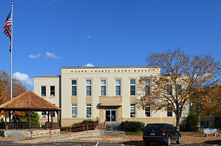
Ozark County is a county in the southern portion of the U.S. state of Missouri. As of the 2020 census, the population was 8,553. The largest city and county seat is Gainesville. The county was organized as Ozark County, named after the Ozark Mountains, on January 29, 1841. It was renamed Decatur County, after Commodore Stephen Decatur, from 1843 to 1845, after which the name Ozark County was restored.

<span class="mw-page-title-main">Oregon County, Missouri</span> County in Missouri

Oregon County is a county located in the southern portion of the U.S. state of Missouri. As of the 2020 census, the population was 8,635. Its county seat is Alton. The county was officially organized on February 14, 1845, and was named for the Oregon Territory in the northwestern United States.

<span class="mw-page-title-main">Livingston County, Missouri</span> County in Missouri, United States

Livingston County is a county located in the northwestern portion of the U.S. state of Missouri. As of the 2020 census, the population was 14,557. Its county seat is Chillicothe. The county was organized January 6, 1837, and named for U.S. Secretary of State Edward Livingston.

<span class="mw-page-title-main">Iron County, Missouri</span> County in Missouri, United States

Iron County is a county located in the Lead Belt region in the U.S. state of Missouri. As of the 2020 census, the population was 9,537. The largest city and county seat is Ironton. Iron County was officially organized on February 17, 1857, and was named after the abundance of iron ore found within its borders.

<span class="mw-page-title-main">Howell County, Missouri</span> County in Missouri, United States

Howell County is in southern Missouri. As of the 2020 census, the population was 39,750. The largest city and county seat is West Plains. The county was officially organized on March 2, 1851, and is named after Josiah Howell, a pioneer settler in the Howell Valley.

<span class="mw-page-title-main">Harrison County, Missouri</span> County in Missouri, United States

Harrison County is a county located in the northwest portion of the U.S. state of Missouri. As of the 2020 census, the population was 8,157. It's county seat is Bethany. The county was organized February 14, 1845, and named for U.S. Representative Albert G. Harrison of Missouri.

<span class="mw-page-title-main">Grundy County, Missouri</span> County in Missouri, United States

Grundy County is a county located in the U.S. state of Missouri. As of the 2020 census, the population was 9,808. Its county seat is Trenton. The county was organized January 2, 1841, from part of Livingston County, Missouri and named after U.S. Attorney General Felix Grundy.

<span class="mw-page-title-main">Gentry County, Missouri</span> County in Missouri, United States

Gentry County is a county located in the northwestern portion of the U.S. state of Missouri. As of the 2020 census, the population was 6,162. Its county seat is Albany. The county was organized February 14, 1841 and named for Colonel Richard Gentry of Boone County, who fell in the Seminole War in 1837.

<span class="mw-page-title-main">Gasconade County, Missouri</span> County in Missouri, United States

Gasconade County is a county located in the east-central portion of the U.S. state of Missouri. As of the 2020 census, the population was 14,794. The county seat has been Hermann since 1842. The county was named after the Gasconade River.

<span class="mw-page-title-main">Douglas County, Missouri</span> County in Missouri, United States

Douglas County is a county located in the south-central portion of the U.S. state of Missouri. As of the 2020 census, the population was 11,578. The county seat and only incorporated community is Ava. The county was officially organized on October 19, 1857, and is named after U.S. Senator Stephen A. Douglas (D-Illinois) and later Democratic presidential candidate.

<span class="mw-page-title-main">DeKalb County, Missouri</span> County in Missouri, United States

DeKalb County is a county located in the northwest portion of the U.S. state of Missouri. As of the 2020 census, the population was 11,029. Its county seat is Maysville. The county was organized February 25, 1845 and named for General Johann de Kalb, Baron de Kalb, of the Revolutionary War.

<span class="mw-page-title-main">Cedar County, Missouri</span> County in Missouri, United States

Cedar County is a county located in the southwest portion of the U.S. state of Missouri. As of the 2020 census, the population was 14,188. Its county seat is Stockton. The county was founded February 14, 1845, and named after Cedar Creek, a tributary of the Sac River, which in turn is named from the Eastern red cedar, a common tree of the area.

<span class="mw-page-title-main">Carroll County, Missouri</span> County in Missouri, United States

Carroll County is a county located in the U.S. state of Missouri. As of the 2020 census, the county had a population of 8,495. Its county seat is Carrollton. The county was organized on January 2, 1833, from part of Ray County and named for Charles Carroll of Carrollton, a signer of the Declaration of Independence.

<span class="mw-page-title-main">Caldwell County, Missouri</span> County in Missouri, United States

Caldwell County is a county located in Missouri, United States. As of the 2020 census, the county's population was 8,815. It is part of the Kansas City metropolitan area. Its county seat is Kingston. The county was organized December 29, 1836, and named by Alexander Doniphan to honor John Caldwell, who participated in George Rogers Clark's Native American Campaign of 1786 and was the second Lieutenant Governor of Kentucky.

<span class="mw-page-title-main">Benton County, Missouri</span> County in Missouri, United States

Benton County is a county located in the west central part of the U.S. state of Missouri. The population was 19,394 as of the 2020 Census. Its county seat is Warsaw. The county was organized January 3, 1835, and named for U.S. Senator Thomas Hart Benton of Missouri.

<span class="mw-page-title-main">Andrew County, Missouri</span> County in Missouri, United States

Andrew County is a county located in the northwestern part of the U.S. state of Missouri. As of the 2020 census, the county had a population of 18,135. Its county seat is Savannah. The county was organized January 29, 1841, and named for Andrew Jackson Davis, a lawyer and prominent citizen of St. Louis.

<span class="mw-page-title-main">Gallatin, Missouri</span> City in Missouri, United States

Gallatin is a city in Daviess County, Missouri, United States. The population was 1,821 at the 2020 census. It is the county seat of Daviess County.

<span class="mw-page-title-main">Jamesport, Missouri</span> City in Missouri, United States

Jamesport is a city in eastern Daviess County, Missouri, United States. The population was 559 at the 2020 census.

References

  1. "QuickFacts: Daviess County, Missouri". Census.gov. Archived from the original on March 7, 2023. Retrieved May 29, 2022.
  2. 1 2 "2020 Population and Housing State Data". United States Census Bureau. Archived from the original on August 12, 2021. Retrieved August 18, 2021.
  3. "Find a County". National Association of Counties. Archived from the original on May 31, 2011. Retrieved June 7, 2011.
  4. Eaton, David Wolfe (1916). How Missouri Counties, Towns and Streams Were Named. The State Historical Society of Missouri. pp.  283.
  5. LeSueur, Stephen C. (1990). The 1838 Mormon War in Missouri. University of Missouri Press. pp. 117–124. ISBN   9780826206268.
  6. Andrew Jensen (1889). The Historical Record, Volumes 5-8. p. 732.
  7. Wilkinson, Darryl (1989). "Daviess County Jury Sides with Frank James". Daviess County Historical Society. Archived from the original on January 2, 2013.
  8. darryl (April 19, 2022). "Spend Some Time Visiting the 1889 Squirrel Cage Jail in Gallatin, MO". Daviess County Historical Society. Archived from the original on December 3, 2023. Retrieved February 21, 2024.
  9. "2010 Census Gazetteer Files". United States Census Bureau. August 22, 2012. Archived from the original on October 21, 2013. Retrieved November 15, 2014.
  10. "U.S. Census Bureau QuickFacts: Daviess County, Missouri". Archived from the original on June 27, 2019. Retrieved June 27, 2019.
  11. "U.S. Decennial Census". United States Census Bureau. Archived from the original on July 1, 2021. Retrieved November 15, 2014.
  12. "Historical Census Browser". University of Virginia Library. Archived from the original on August 11, 2012. Retrieved November 15, 2014.
  13. "Population of Counties by Decennial Census: 1900 to 1990". United States Census Bureau. Archived from the original on December 3, 2014. Retrieved November 15, 2014.
  14. "Census 2000 PHC-T-4. Ranking Tables for Counties: 1990 and 2000" (PDF). United States Census Bureau. Archived (PDF) from the original on March 27, 2010. Retrieved November 15, 2014.
  15. "U.S. Census website". United States Census Bureau. Archived from the original on December 27, 1996. Retrieved May 14, 2011.
  16. "Daviess County , Missouri - County Membership Report (2020)". The Association of Religion Data Archives. Archived from the original on September 30, 2023. Retrieved October 23, 2023.
  17. "P2 HISPANIC OR LATINO, AND NOT HISPANIC OR LATINO BY RACE – 2020: DEC Redistricting Data (PL 94-171) – Daviess County, Missouri". Archived from the original on September 24, 2022. Retrieved September 24, 2022.
  18. Breeding, Marshall. "Daviess County Library". Libraries.org. Archived from the original on May 14, 2021. Retrieved May 8, 2017.
  19. Leip, David. "Dave Leip's Atlas of U.S. Presidential Elections". uselectionatlas.org. Archived from the original on March 23, 2018. Retrieved March 25, 2018.

39°58′N93°59′W / 39.96°N 93.99°W / 39.96; -93.99