Polk County, Missouri

Last updated

Polk County
Bolivarmo2-retouched.jpg
Polk County Courthouse in Bolivar
Map of Missouri highlighting Polk County.svg
Location within the U.S. state of Missouri
Missouri in United States.svg
Missouri's location within the U.S.
Coordinates: 37°37′N93°24′W / 37.62°N 93.4°W / 37.62; -93.4
CountryFlag of the United States.svg United States
StateFlag of Missouri.svg  Missouri
FoundedMarch 13, 1835
Named for Ezekiel Polk
Seat Bolivar
Largest cityBolivar
Area
  Total642 sq mi (1,660 km2)
  Land636 sq mi (1,650 km2)
  Water6.9 sq mi (18 km2)  1.1%
Population
 (2020)
  Total31,519
  Density49/sq mi (19/km2)
Time zone UTC−6 (Central)
  Summer (DST) UTC−5 (CDT)
Congressional district 4th

Polk County is a county located in the southwestern portion of the U.S. state of Missouri. As of the 2020 census, the population was 31,519. [1] Its county seat is Bolivar. [2] The county was organized January 5, 1835, [3] and named for Ezekiel Polk.

Contents

Polk County is part of the Springfield, MO Metropolitan Statistical Area.

History

Polk County was separated and organized from Greene County on January 5, 1835. A supplement to the boundary change was made on March 13, 1835. [3] [4] Its original boundaries were later reduced in creating Dade, Dallas, and Hickory counties. It was named in honor of Col. Ezekiel Polk of Tennessee, a soldier who served under General George Washington and who was the grandfather of John Polk Campbell and Ezekiel Madison Campbell, brothers who helped to settle Polk and Greene counties. [5] Ezekiel Polk was also the grandfather of James K. Polk, who was a member of the US House of Representatives in 1835. He was elected President of the United States in 1844. [6]

Geography

According to the U.S. Census Bureau, the county has a total area of 642 square miles (1,660 km2), of which 636 square miles (1,650 km2) is land and 6.9 square miles (18 km2) (1.1%) is water. [7]

Adjacent counties

Major highways

Transit

Demographics

Historical population
CensusPop.Note
1840 8,449
1850 6,186−26.8%
1860 9,99561.6%
1870 12,44524.5%
1880 15,73426.4%
1890 20,33929.3%
1900 23,25514.3%
1910 21,561−7.3%
1920 20,351−5.6%
1930 17,803−12.5%
1940 17,400−2.3%
1950 16,062−7.7%
1960 13,753−14.4%
1970 15,41512.1%
1980 18,82222.1%
1990 21,82616.0%
2000 26,99223.7%
2010 31,13715.4%
2020 31,5191.2%
U.S. Decennial Census [8]
1790-1960 [9] 1900-1990 [10]
1990-2000 [11] 2010 [12]

As of the census [13] of 2000, there were 26,992 people, 9,917 households, and 7,140 families residing in the county. The population density was 42 inhabitants per square mile (16/km2). There were 11,183 housing units at an average density of 18 units per square mile (6.9/km2). The racial makeup of the county was 97.26% White, 0.45% Black or African American, 0.67% Native American, 0.19% Asian, 0.03% Pacific Islander, 0.33% from other races, and 1.06% from two or more races. Approximately 1.30% of the population were Hispanic or Latino of any race.

There were 9,917 households, out of which 33.00% had children under the age of 18 living with them, 60.50% were married couples living together, 8.20% had a female householder with no husband present, and 28.00% were non-families. 23.20% of all households were made up of individuals, and 10.70% had someone living alone who was 65 years of age or older. The average household size was 2.56 and the average family size was 3.02.

In the county, the population was spread out, with 25.70% under the age of 18, 12.60% from 18 to 24, 25.50% from 25 to 44, 20.80% from 45 to 64, and 15.30% who were 65 years of age or older. The median age was 35 years. For every 100 females, there were 94.90 males. For every 100 females age 18 and over, there were 90.90 males.

The median income for a household in the county was $29,656, and the median income for a family was $35,843. Males had a median income of $25,383 versus $18,799 for females. The per capita income for the county was $13,645. About 11.10% of families and 16.30% of the population were below the poverty line, including 20.00% of those under age 18 and 12.00% of those age 65 or over.

2020 Census

Polk County Racial Composition [14]
RaceNum.Perc.
White (NH)28,68291%
Black or African American (NH)2420.76%
Native American (NH)1900.6%
Asian (NH)1310.42%
Pacific Islander (NH)40.01%
Other/Mixed (NH)1,4794.7%
Hispanic or Latino 7912.51%

Education

Public libraries

Media

The Bolivar Herald-Free Press is published twice weekly.

Communities

Cities

Villages

Unincorporated communities

Townships

Polk County is divided into 22 townships:

Politics

Local

The Republican Party completely controls politics at the local level in Polk County. Republicans hold all of the elected positions in the county.

Polk County, Missouri
Elected countywide officials
Assessor Rita Lemmon Republican
Circuit Clerk Tiffany Phillips Republican
County Clerk Rachel Lightfoot Republican
Collector Rachel Boyce Republican
Commissioner
(Presiding)
Shannon Hancock Republican
Commissioner
(District 1)
Kyle Legan Republican
Commissioner
(District 2)
Melinda Robertson Republican
Coroner Jeff Witt Republican
Prosecuting Attorney Keaton Ashlock Republican
Public Administrator Barbara Davolt Republican
Recorder Carol Poindexter Republican
Sheriff Danny Morrison Republican
Surveyor Kevin Nelson Republican
Treasurer Shirley Allison Republican

State

Past Gubernatorial Elections Results
Year Republican Democratic Third Parties
2020 81.7%12,31916.4% 2,4751.9% 278
2016 66.92%9,25130.15% 4,1682.92% 404
2012 53.89%7,05243.15% 5,6472.96% 388
2008 45.76% 6,24449.52%6,7584.72% 644
2004 67.84%8,41830.90% 3,8351.56% 1.26
2000 58.65%5,99639.79% 4,0681.55% 159
1996 55.64%5,04340.51% 3,6723.85% 349

All of Polk County is in the 128th district in the Missouri House of Representatives, and is represented by Mike Stephens (R-Bolivar).

Missouri House of Representatives — District 128 — Polk County (2016)
PartyCandidateVotes%±%
Republican Mike Stephens11,50085.48%-14.52
Independent Janet Sheffield1,95314.52%+14.52
Missouri House of Representatives — District 128 — Polk County (2014)
PartyCandidateVotes%±%
Republican Sue Entichler5,903100.00%
Missouri House of Representatives — District 128 — Polk County (2012)
PartyCandidateVotes%±%
Republican Sue Entlicher11,744100.00%

All of Polk County is a part of Missouri's 28th District in the Missouri Senate, which is currently vacant. The previous incumbent, Mike Parson, was elected Missouri Lieutenant Governor in November 2016.

Missouri Senate — District 28 — Polk County (2014)
PartyCandidateVotes%±%
Republican Mike Parson5,832100.00%

Federal

U.S. Senate — Missouri — Polk County (2016)
PartyCandidateVotes%±%
Republican Roy Blunt9,69369.93%+17.50
Democratic Jason Kander3,60526.01%-14.35
Libertarian Jonathan Dine3272.36%-4.85
Green Johnathan McFarland1070.77%+0.77
Constitution Fred Ryman1290.93%+0.93
U.S. Senate — Missouri — Polk County (2012)
PartyCandidateVotes%±%
Republican Todd Akin6,78952.43%
Democratic Claire McCaskill5,22640.36%
Libertarian Jonathan Dine9337.21%

All of Polk county is included in Missouri's 7th Congressional District and is currently represented by Billy Long (R-Springfield) in the U.S. House of Representatives.

U.S. House of Representatives — Missouri's 7th Congressional District — Polk County (2016)
PartyCandidateVotes%±%
Republican Billy Long10,17074.34%+6.06
Democratic Genevieve Williams2,88021.05%-2.42
Libertarian Benjamin T. Brixey6304.61%-3.64
U.S. House of Representatives — Missouri's 7th Congressional District — Polk County (2014)
PartyCandidateVotes%±%
Republican Billy Long4,44268.28%+1.25
Democratic Jim Evans1,52723.47%-4.21
Libertarian Kevin Craig5378.25%+2.95
U.S. House of Representatives — Missouri’s 7th Congressional District — Polk County (2012)
PartyCandidateVotes%±%
Republican Billy Long8,63167.03%
Democratic Jim Evans3,56427.68%
Libertarian Kevin Craig6825.30%

Political culture

Polk County has been a Republican Party stronghold for most of its history at the presidential level. In only four presidential elections from 1896 to the present has a Democratic Party candidate carried the county, the most recent being Lyndon B. Johnson in 1964.

United States presidential election results for Polk County, Missouri [16]
Year Republican Democratic Third party
No.%No.%No.%
2020 11,85078.49%2,88519.11%3632.40%
2016 10,43875.84%2,63119.12%6945.04%
2012 9,25270.52%3,58027.29%2872.19%
2008 8,95665.39%4,55333.24%1881.37%
2004 8,58668.95%3,77530.31%920.74%
2000 6,43062.46%3,60635.03%2582.51%
1996 4,52149.74%3,30736.38%1,26113.87%
1992 3,46539.94%3,31638.22%1,89421.83%
1988 5,03059.39%3,41940.37%210.25%
1984 5,46765.98%2,81934.02%00.00%
1980 4,84257.86%3,33639.87%1902.27%
1976 3,89351.29%3,66348.26%340.45%
1972 5,40970.67%2,24529.33%00.00%
1968 4,14559.82%2,17031.32%6148.86%
1964 3,28849.51%3,35350.49%00.00%
1960 4,84966.52%2,44033.48%00.00%
1956 4,41059.77%2,96840.23%00.00%
1952 5,26367.81%2,47431.88%240.31%
1948 4,02656.65%3,07943.32%20.03%
1944 5,04066.45%2,52733.32%180.24%
1940 5,53461.98%3,38037.86%140.16%
1936 5,12656.65%3,89943.09%230.25%
1932 3,81146.40%4,35553.03%470.57%
1928 5,30769.63%2,30330.22%120.16%
1924 4,09756.19%3,03341.60%1612.21%
1920 4,96762.82%2,84736.01%931.18%
1916 2,61353.79%2,14944.24%961.98%
1912 1,80239.04%1,93541.92%87919.04%
1908 2,67054.43%2,13943.61%961.96%
1904 2,65956.88%1,80738.65%2094.47%
1900 2,67953.59%2,17843.57%1422.84%
1896 2,56448.32%2,71151.09%310.58%
1892 1,91845.98%1,21129.03%1,04224.98%
1888 2,10048.97%1,79441.84%3949.19%

Missouri presidential preference primary (2008)

Former Governor Mike Huckabee (R-Arkansas) received more votes, a total of 2,317, than any candidate from either party in Polk County during the 2008 presidential primary.

See also

Related Research Articles

<span class="mw-page-title-main">Hardeman County, Tennessee</span> County in Tennessee, United States

Hardeman County is a county located in the U.S. state of Tennessee. As of the 2020 census, the population was 25,462. Its county seat is Bolivar.

<span class="mw-page-title-main">St. Clair County, Missouri</span> County in Missouri, United States

St. Clair County is a county located in the western portion of the U.S. state of Missouri. As of the 2020 census, the population was 9,284. Its county seat is Osceola. The largest city is Appleton City. The county was organized in 1841 and named after General Arthur St. Clair, Governor of the Northwest Territory. St. Clair was also the 9th president of the United States in Congress Assembled. Under his presidency, the Northwest Ordinance and United States Constitution were passed.

<span class="mw-page-title-main">Shelby County, Missouri</span> County in Missouri, United States

Shelby County is a county located in the northeastern portion of the U.S. state of Missouri. As of the 2020 census, the population was 6,103. Its county seat is Shelbyville. The county was established on January 2, 1835, and named for Governor Isaac Shelby of Kentucky.

<span class="mw-page-title-main">Hickory County, Missouri</span> County in Missouri, United States

Hickory County is located in the U.S. state of Missouri. As of the 2020 census, the population was 8,279. Its county seat is Hermitage. The county was organized February 14, 1845, and named after President Andrew Jackson, whose nickname was "Old Hickory." The Pomme de Terre Dam, a Corps of Engineers facility, is located three miles south of Hermitage and forms Lake Pomme de Terre by damming the Pomme de Terre River and Lindley Creek. Truman Reservoir, also a Corps of Engineers facility, floods the Pomme de Terre Reservoir from the northern border of the county southward to the city limits of Hermitage.

<span class="mw-page-title-main">Dallas County, Missouri</span> County in Missouri, United States

Dallas County is a county located in the U.S. state of Missouri. As of the 2010 census, the population was 17,071. Its county seat is Buffalo. The county was organized in 1842 as Niangua County and then renamed in 1844 for George M. Dallas, who served as Vice President under James K. Polk.

<span class="mw-page-title-main">Dade County, Missouri</span> County in Missouri, United States

Dade County is a county located in the southwest part of the U.S. state of Missouri. As of the 2020 census, the population was 7,569. Its county seat is Greenfield. The county was organized in 1841 and named after Major Francis L. Dade of Virginia, who was killed in the Second Seminole War in 1835.

<span class="mw-page-title-main">Cedar County, Missouri</span> County in Missouri, United States

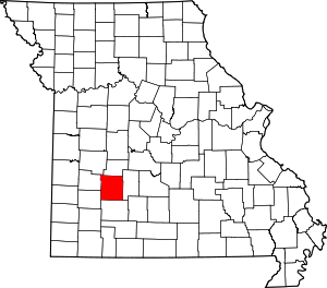
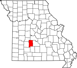
Cedar County is a county located in the southwest portion of the U.S. state of Missouri. As of the 2020 census, the population was 14,188. Its county seat is Stockton. The county was founded February 14, 1845, and named after Cedar Creek, a tributary of the Sac River, which in turn is named from the Eastern red cedar, a common tree of the area.

<span class="mw-page-title-main">Pennington County, Minnesota</span> County in Minnesota, United States

Pennington County is a county in the northwestern part of the U.S. state of Minnesota. As of the 2020 census, the population was 13,992. Its county seat is Thief River Falls.

<span class="mw-page-title-main">Wayne County, Illinois</span> County in Illinois, United States

Wayne County is a county located in the U.S. state of Illinois. According to the 2020 census, it had a population of 16,179. Its county seat is Fairfield. It is located in the southern portion of Illinois known locally as "Little Egypt".

<span class="mw-page-title-main">Dade County, Georgia</span> County in Georgia, United States

Dade County is a county in the U.S. state of Georgia. It occupies the northwest corner of Georgia, and the county's own northwest corner is the westernmost point in the state. As of the 2020 census, the population is 16,251. The county seat and only incorporated municipality is Trenton. Dade County is part of the Chattanooga, TN–GA Metropolitan Statistical Area. In 1860, residents of Dade County voted to secede from the state of Georgia and from the United States, but no government outside the county ever recognized this gesture as legal. In 1945, the county symbolically "rejoined" Georgia and the United States.

<span class="mw-page-title-main">Hermitage, Missouri</span> City in Missouri, United States

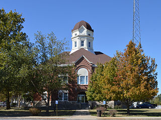
Hermitage is a city in Hickory County, Missouri, United States, on the Pomme de Terre River. The population was 621 at the 2020 census. It is the county seat of Hickory County. The John Siddles Williams House on Museum Street in Hermitage, on the National Register of Historic Places since 1980, houses the Hickory County Historical Society Museum and Research Room.

<span class="mw-page-title-main">Wheatland, Missouri</span> City in Missouri, United States

Wheatland is a city in Hickory County, Missouri, United States. The population was 277 at the 2020 census.

<span class="mw-page-title-main">Aldrich, Missouri</span> Village in Missouri, United States

Aldrich is a village in southwestern Polk County, Missouri, United States. The population was 80 at the 2010 census. It is part of the Springfield, Missouri Metropolitan Statistical Area.

<span class="mw-page-title-main">Bolivar, Missouri</span> City in Missouri, United States

Bolivar is a city and county seat of Polk County, Missouri, United States.

<span class="mw-page-title-main">Fair Play, Missouri</span> City in Missouri, United States

Fair Play is a city in western Polk County, Missouri, United States. The population was 475 at the 2010 census. It is part of the Springfield, Missouri Metropolitan Statistical Area.

<span class="mw-page-title-main">Morrisville, Missouri</span> City in Missouri, United States

Morrisville is a city in southern Polk County, Missouri, United States. The population was 388 at the 2010 census. It is part of the Springfield, Missouri Metropolitan Statistical Area.

<span class="mw-page-title-main">Penn Forest Township, Pennsylvania</span> Place in Pennsylvania, United States

Penn Forest Township is a township in Carbon County, Pennsylvania. It is part of Northeastern Pennsylvania. The population was 9,581 at the 2010 census, up from 5,439 at the 2000 census.

<span class="mw-page-title-main">Hickory Township, Forest County, Pennsylvania</span> Township in Pennsylvania, United States

Hickory Township is a township in Forest County, Pennsylvania, United States. As of the 2020 census, the township population was 416, a decline from 558 in 2010.

<span class="mw-page-title-main">Mount Pleasant Township, Washington County, Pennsylvania</span> Township in Pennsylvania, United States

Mount Pleasant Township is a township in Washington County, Pennsylvania, United States. As of the 2020 census, the township population was 3,282.

<span class="mw-page-title-main">Kerton Township, Fulton County, Illinois</span> Township in Illinois, United States

Kerton Township is one of twenty-six townships in Fulton County, Illinois, USA. As of the 2020 census, its population was 79 and it contained 68 housing units.

References

  1. "Polk County, Missouri". United States Census Bureau . Retrieved June 14, 2023.
  2. "Find a County". National Association of Counties. Retrieved June 7, 2011.
  3. 1 2 Laws of a public and general nature of the State of Missouri passed between the years 1824 & 1836" Volume II, published 1842, pg. 432-433 https://mdh.contentdm.oclc.org/digital/collection/molaws/id/42050/rec/3
  4. "History of Hickory, Polk, Cedar, Dade, and Barton counties, Missouri." published 1889, Goodspeed Publishing, page 286
  5. “Polk County Classics, a Sesquicentennial Photograph Album, 1835-1985” by George Francis Hooper and James C. Sterling, published 1985, page 4 “History and Families of Polk County, Missouri” published 2002 by the Polk County Genealogical Society, Inc. page 8
  6. "POLK, James Knox | US House of Representatives: History, Art & Archives".
  7. "2010 Census Gazetteer Files". United States Census Bureau. August 22, 2012. Archived from the original on October 21, 2013. Retrieved November 18, 2014.
  8. "U.S. Decennial Census". United States Census Bureau. Retrieved November 18, 2014.
  9. "Historical Census Browser". University of Virginia Library. Retrieved November 18, 2014.
  10. "Population of Counties by Decennial Census: 1900 to 1990". United States Census Bureau. Retrieved November 18, 2014.
  11. "Census 2000 PHC-T-4. Ranking Tables for Counties: 1990 and 2000" (PDF). United States Census Bureau. Archived (PDF) from the original on March 27, 2010. Retrieved November 18, 2014.
  12. "State & County QuickFacts". United States Census Bureau. Archived from the original on August 11, 2011. Retrieved September 12, 2013.
  13. "U.S. Census website". United States Census Bureau . Retrieved January 31, 2008.
  14. "P2 HISPANIC OR LATINO, AND NOT HISPANIC OR LATINO BY RACE – 2020: DEC Redistricting Data (PL 94-171) – Polk County, Missouri".
  15. Breeding, Marshall. "Polk County Public Library". Libraries.org. Retrieved May 8, 2017.
  16. Leip, David. "Dave Leip's Atlas of U.S. Presidential Elections". uselectionatlas.org. Retrieved March 26, 2018.

37°37′N93°24′W / 37.62°N 93.40°W / 37.62; -93.40