Dunklin County, Missouri

Last updated

Dunklin County
Dunklin Co Missouri Courthouse 20170128-3726.-3728.jpg
Dunklin County Courthouse in Kennett
Map of Missouri highlighting Dunklin County.svg
Location within the U.S. state of Missouri
Missouri in United States.svg
Missouri's location within the U.S.
Coordinates: 36°16′N90°05′W / 36.27°N 90.09°W / 36.27; -90.09
CountryFlag of the United States.svg United States
StateFlag of Missouri.svg  Missouri
FoundedFebruary 14, 1845
Named for Daniel Dunklin
Seat Kennett
Largest cityKennett
Area
  Total547 sq mi (1,420 km2)
  Land541 sq mi (1,400 km2)
  Water6.1 sq mi (16 km2)  1.1%
Population
 (2020)
  Total28,283
  Density52/sq mi (20/km2)
Time zone UTC−6 (Central)
  Summer (DST) UTC−5 (CDT)
Congressional district 8th
Website dunklincounty.org

Dunklin County is located in the Bootheel of the U.S. state of Missouri. As of the 2020 census, the population was 28,283. [1] The largest city and county seat is Kennett. [2] The county was officially organized on February 14, 1845, [3] and is named in honor of Daniel Dunklin, [4] a Governor of Missouri who died the year before the county was organized.

Contents

Dunklin County comprises the Kennett, MO Micropolitan Statistical Area.

Geography

According to the U.S. Census Bureau, the county has a total area of 547 square miles (1,420 km2), of which 541 square miles (1,400 km2) is land and 6.1 square miles (16 km2) (1.1%) is water. [5] The lowest point in the state of Missouri is located on the St. Francis River in Buffalo Township in Dunklin County, where it flows out of Missouri and into Arkansas.

Adjacent counties

Demographics

Historical population
CensusPop.Note
1850 1,229
1860 5,026309.0%
1870 5,98219.0%
1880 9,60460.5%
1890 15,08557.1%
1900 21,70643.9%
1910 30,32839.7%
1920 32,7738.1%
1930 35,7999.2%
1940 44,95725.6%
1950 45,3290.8%
1960 39,139−13.7%
1970 33,742−13.8%
1980 36,3247.7%
1990 33,112−8.8%
2000 33,1550.1%
2010 31,953−3.6%
2020 28,283−11.5%
U.S. Decennial Census [6]
1790-1960 [7] 1900-1990 [8]
1990-2000 [9] 2010-2015 [10] 2020 [1]

As of the census [11] of 2000, there were 33,155 people, 13,411 households, and 9,159 families residing in the county. The population density was 61 people per square mile (24 people/km2). There were 14,682 housing units at an average density of 27 units per square mile (10/km2). The racial makeup of the county was 88.64% White, 8.68% Black or African American, 0.31% Native American, 0.27% Asian, 0.01% Pacific Islander, 1.03% from other races, and 1.06% from two or more races. Approximately 2.49% of the population were Hispanic or Latino of any race. Among the major first ancestries reported in Dunklin County were 38.8% American, 10.6% Irish, 8.2% German, and 7.5% English ancestry.

There were 13,411 households, of which 31.30% had children under the age of 18 living with them, 51.60% were married couples living together, 13.20% had a female householder with no husband present, and 31.70% were "non-families." Of all households, 28.10% consisted of individuals and 14.00% had someone living alone who was 65 years of age or older. The average household size was 2.42 and the average family size was 2.94.

Of the county's population, 26.00% were under the age of 18, 8.10% were from 18 to 24, 26.00% were from 25 to 44, 23.50% were from 45 to 64, and 16.50% were 65 years of age or older. The median age was 38 years. For every 100 females there were 89.60 males. For every 100 women age 18 and over, there were 85.10 men.

The median income for a household in the county was $30,927, and the median income for a family was $38,439. Males had a median income of $27,288 versus $18,142 for females. The per capita income for the county was $16,737. About 19.40% of families and 24.50% of the population were below the poverty line, including 33.90% of those under age 18 and 21.30% of those age 65 or over. Of the state's 115 counties, in 2010 Dunklin ranked 105th in terms of poverty. [12] [13]

Religion

According to the Association of Religion Data Archives County Membership Report (2000), Dunklin County is a part of the Bible Belt with evangelical Protestantism being the majority religion. The most predominant denominations among residents in Dunklin County who adhere to a religion are Southern Baptists (64.11%), Methodists (8.66%), and Churches of Christ (6.74%).

2020 Census

Dunklin County Racial Composition [14]
RaceNum.Perc.
White (NH)21,62976.47%
Black or African American (NH)3,17611.23%
Native American (NH)700.25%
Asian (NH)780.28%
Pacific Islander (NH)40.01%
Other/Mixed (NH)1,2844.54%
Hispanic or Latino 2,0427.22%

Education

Of adults 25 years of age and older in Dunklin County, 63.7% possess a high school diploma or higher while 9.1% hold a bachelor's degree or higher as their highest educational attainment.

Public schools

Private schools

Alternative and vocational schools

Public libraries

Transportation

Major highways

Airports

Kennett Memorial Airport is a public-use airport in Dunklin County. It is located one nautical mile (1.85 km) southeast of the central business district of Kennett, which owns the airport. [16]

Health care

The county no longer has a hospital as the Twin Rivers Regional Medical Center closed on June 11, 2018. The nearest hospital is now Pemiscot County Hospital in Hayti. The region suffers from high infant and maternal mortality rates. [17]

Media

Radio

FM

AM

Print

Television

There are no television stations in Dunklin County, Missouri. Dunklin County, Missouri is placed in the Paducah, KY, Cape Girardeau, MO, & Harrisburg, Illinois Television Market. Those stations include:

However some residents in the south end of the county watch stations from the Memphis, TN and Jonesboro, AR Television Markets.

Politics

Local

Dunklin County was once a Democratic stronghold. However, like the rest of Southeast Missouri and the Bootheel in particular, the county has swung Republican. In 2020 alone, three formerly Democratic officials switched their registration to Republican, and Republicans now control every elected office.

Dunklin County, Missouri
Elected countywide officials
Assessor Rena Ingram Republican
Circuit Clerk Paula Gargus Republican
County Clerk Kent Hampton Republican
Commissioner
(Presiding)
Don Collins Republican
Commissioner
(District 1)
Ron Huber Republican
Commissioner
(District 2)
Patrick McHaney Republican
Coroner James Powell Republican
Prosecuting Attorney Nicholas Jain Republican
Public Administrator Matt Jackson Republican
Recorder Angela Casey Republican
Sheriff Bob Holder Republican
Treasurer/Collector Judy Thompson Republican

State

Past Gubernatorial Elections Results
Year Republican Democratic Third Parties
2020 76.40%7,88022.10% 2,2811.10% 118
2016 69.40%7,25328.90% 3,0140.80% 84
2012 43.55% 4,56054.03%5,6572.43% 254
2008 41.65% 4,79256.13%6,4582.22% 255
2004 52.46%6,01546.25% 5,3021.29% 148
2000 42.70% 4,47156.11%5,8751.19% 125
199631.51% 3,23266.86%6,8581.63% 167
199239.36% 4,30960.64%6,6400.00% 0
198858.16%5,82241.74% 4,1780.10% 10
198451.01%5,40748.99% 5,1930.00% 0
198046.29% 5,20353.62%6,0260.09% 10
197640.86% 4,13159.08%5,9740.06% 6
197249.07% 4,23950.85%4,3930.09% 7
196825.16% 2,87974.84%8,5660.00% 0
196424.32% 2,80475.68%8,7240.00% 0
196030.71% 3,93869.29%8,8840.00% 0

In the Missouri House of Representatives, Dunklin County is divided into two legislative districts, both of which are represented by Republicans. [19]

Missouri House – District 150 – Dunklin County (2020)
PartyCandidateVotes%±%
Republican Andrew McDaniel100.00%
Missouri House – District 150 – Dunklin County (2018) [20]
PartyCandidateVotes%±%
Republican Andrew McDaniel4,52179.14%
Democratic Josh Rittenberry1,19220.86%
Missouri House – District 150 – Dunklin County (2016) [21]
PartyCandidateVotes%±%
Republican Andrew McDaniel5,22669.10%
Democratic Lena Samford2,33730.90%
Missouri House – District 150 – Dunklin County (2014) [22]
PartyCandidateVotes%±%
Republican Andrew McDaniel1,93447.62%
Democratic Walter Dearing2,12752.48%
Missouri House – District 152 – Dunklin County (2020)
PartyCandidateVotes%±%
Republican Hardy Billington100.00%
Missouri House – District 152 – Dunklin County (2018) [23]
PartyCandidateVotes%±%
Republican Hardy Billington1,48368.44%
Democratic Robert L. Smith68431.56%
Missouri House – District 152 – Dunklin County (2016)
PartyCandidateVotes%±%
Republican Todd Richardson100.00%
Missouri House – District 152 – Dunklin County (2014)
PartyCandidateVotes%±%
Republican Todd Richardson100.00%

In the Missouri Senate, all of Dunklin County is a part of Missouri's 25th District and is currently represented by Republican Jason Bean of Poplar Bluff. [24]

Missouri Senate – District 25 – Dunklin County (2020)
PartyCandidateVotes%±%
Republican Jason Bean100.00%
Missouri Senate – District 25 – Dunklin County (2016) [25]
PartyCandidateVotes%±%
Republican Doug Libla6,95268.51%
Democratic William D. "Bill" Burlison3,19531.49%
Missouri Senate – District 25 – Dunklin County (2012) [26]
PartyCandidateVotes%±%
Republican Doug Libla5,05648.65%
Democratic Terry Swinger5,33751.35%

Federal

Missouri's two U.S. Senators are Republican Josh Hawley of Columbia and Republican Roy Blunt of Strafford.

McCaskill was reelected to her second term in 2012 with 54.81 percent of the statewide vote over former Republican U.S. Representative W. Todd Akin of Town & Country and Libertarian Jonathan Dine of Riverside; Dunklin County gave McCaskill just over 50 and a half percent of the vote.

U.S. Senate - Class I – Dunklin County (2012)
PartyCandidateVotes%±%
Democratic Claire McCaskill5,34750.69
Republican W. Todd Akin4,80645.56
Libertarian Jonathan Dine3953.74
U.S. Senate - Class I – Dunklin County (2018) [27]
PartyCandidateVotes%±%
Democratic Claire McCaskill1,98824.90
Republican Josh Hawley5,80272.70
Independent Craig O'Dear821.00

Blunt was elected to his first term in 2010 with 54.23 percent of the statewide vote over former Democratic Missouri Secretary of State Robin Carnahan, Libertarian Jonathan Dine of Riverside, and Constitutionalist Jerry Beck of Novelty; Dunklin County voters backed Blunt with just under 62 and a half percent of the vote.

U.S. Senate - Class III – Dunklin County (2010)
PartyCandidateVotes%±%
Republican Roy Blunt4,30662.48
Democratic Robin Carnahan2,36334.29
Libertarian Jonathan Dine1211.76
Constitution Jerry Beck1021.48
U.S. Senate - Class III – Dunklin County (2016) [28]
PartyCandidateVotes%±%
Republican Roy Blunt6,53663.00
Democratic Jason Kander3,43333.10
Libertarian Jonathan Dine1721.70

All of Dunklin County is included in Missouri's 8th Congressional District and is currently represented by Republican Jason T. Smith of Salem in the U.S. House of Representatives. Smith won a special election on Tuesday, June 4, 2013, to complete the remaining term of former Republican U.S. Representative Jo Ann Emerson of Cape Girardeau. Emerson announced her resignation a month after being reelected with over 70 percent of the vote in the district. She resigned to become CEO of the National Rural Electric Cooperative.

U.S. House of Representatives - District 8 – Dunklin County (2012)
PartyCandidateVotes%±%
Republican Jo Ann Emerson7,41670.66+4.06
Democratic Jack Rushin2,88427.48-3.34
Libertarian Rick Vandeven1961.87+0.87
U.S. House of Representatives - District 8 - Special Election – Dunklin County (2013)
PartyCandidateVotes%±%
Republican Jason T. Smith1,40767.22
Democratic Steve Hodges61829.53
Constitution Doug Enyart371.77
Libertarian Bill Slantz301.43
Write-In Thomas Brown10.05
U.S. House of Representatives - District 8 – Dunklin County (2018) [29]
PartyCandidateVotes%±%
Republican Jason T. Smith5,97875.50
Democratic Kathy Ellis1,85723.50
Libertarian Jonathan Shell811.00
U.S. House of Representatives - District 8 – Dunklin County (2020) [30]
PartyCandidateVotes%±%
Republican Jason T. Smith7,97878.40
Democratic Kathy Ellis2,07420.40
Libertarian Tom Schmitz1291.30

Political culture

United States presidential election results for Dunklin County, Missouri [31]
Year Republican Democratic Third party
No.%No.%No.%
2020 8,13578.08%2,20021.12%840.81%
2016 8,02675.87%2,36022.31%1921.82%
2012 6,85064.31%3,63634.14%1651.55%
2008 7,04459.88%4,54038.59%1801.53%
2004 6,72057.55%4,90141.97%560.48%
2000 5,42651.55%4,94747.00%1521.44%
1996 3,76637.02%5,42853.36%9799.62%
1992 4,02435.06%6,27754.68%1,17810.26%
1988 5,02648.70%5,28151.17%130.13%
1984 6,09255.09%4,96744.91%00.00%
1980 5,25345.56%6,12053.08%1571.36%
1976 3,31431.73%7,10768.06%220.21%
1972 5,92668.10%2,77631.90%00.00%
1968 4,36635.40%5,06341.06%2,90323.54%
1964 3,46529.04%8,46770.96%00.00%
1960 6,70850.53%6,56849.47%00.00%
1956 4,94336.24%8,69863.76%00.00%
1952 5,40036.18%9,51563.76%90.06%
1948 2,46618.32%10,97981.56%160.12%
1944 4,27433.57%8,43166.22%270.21%
1940 5,51633.07%11,13266.74%320.19%
1936 3,77526.84%10,23372.75%580.41%
1932 1,97717.63%9,14181.54%930.83%
1928 3,60242.37%4,87957.39%200.24%
1924 3,43642.67%4,35754.11%2593.22%
1920 4,45544.72%5,19952.18%3093.10%
1916 1,92431.89%3,72361.71%3866.40%
1912 98718.81%2,72351.89%1,53829.31%
1908 1,63835.17%2,73458.69%2866.14%
1904 1,46138.47%2,22958.69%1082.84%
1900 1,27631.43%2,71166.77%731.80%
1896 96124.38%2,97575.47%60.15%
1892 65922.00%2,16772.33%1705.67%
1888 71928.12%1,83871.88%00.00%

Historically, Dunklin County has tended to support Democrats at the presidential level. A predominantly rural county in the heavily impoverished Bootheel with a fairly substantial African American population, Democrats at all levels have historically performed quite well in Dunklin County. Bill Clinton of neighboring Arkansas was the last Democratic presidential nominee to carry the county in 1996; since then, Dunklin County has, like virtually all counties throughout the state, experienced a rapid trend rightward, as Republicans have been surging at the presidential level. Voters in Dunklin County have left their historically Democratic roots as Republicans hold all the local elected offices in the county, and statewide elections have done much the same.

Like most rural areas throughout Missouri, voters in Dunklin County generally adhere to socially and culturally conservative principles but are more moderate or populist on economic issues, typical of the Dixiecrat philosophy. In 2004, Missourians voted on a constitutional amendment to define marriage as the union between a man and a woman—it overwhelmingly passed Dunklin County with 87.57 percent of the vote. The initiative passed the state with 71 percent of support from voters as Missouri became the first state to ban same-sex marriage. In 2006, Missourians voted on a constitutional amendment to fund and legalize embryonic stem cell research in the state—it failed in Dunklin County with 53.70 percent voting against the measure. The initiative narrowly passed the state with 51 percent of support from voters as Missouri became one of the first states in the nation to approve embryonic stem cell research. Despite Dunklin County's longstanding tradition of supporting socially conservative platforms, voters in the county have a penchant for advancing populist causes like increasing the minimum wage. In 2006, Missourians voted on a proposition (Proposition B) to increase the minimum wage in the state to $6.50 an hour—it passed Dunklin County with 79.42 percent of the vote. The proposition strongly passed every single county in Missouri with 78.99 percent voting in favor as the minimum wage was increased to $6.50 an hour in the state. During the same election, voters in five other states also strongly approved increases in the minimum wage.

Missouri presidential preference primary (2008)

In the 2008 Missouri Presidential Preference Primary, voters in Dunklin County from both political parties supported candidates who finished in second place in the state at large and nationally.

Former U.S. Senator Hillary Clinton (D-New York) received more votes in Dunklin County, 2,587, than any candidate from either party during the 2008 Missouri Democratic presidential preference primary. The 2,587 is more votes than the total number cast in the entire Republican primary in Dunklin County.

Communities

Notable people

See also

Related Research Articles

<span class="mw-page-title-main">Wayne County, Missouri</span> County in Missouri, United States

Wayne County is a county located in the Ozark foothills in the U.S. state of Missouri. As of the 2020 census, the population was 10,974. The county seat is Greenville. The county was officially organized on December 11, 1818, and is named after General "Mad" Anthony Wayne, who served in the American Revolution. As of August 28, 2023, Wayne County is designated the UFO Capital of Missouri, along with the city of Piedmont.

<span class="mw-page-title-main">Stoddard County, Missouri</span> County in Missouri, United States

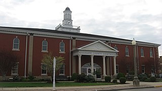
Stoddard County is a county located in the southeastern portion of the U.S. state of Missouri. As of the 2020 census, the population was 28,672. The county seat is Bloomfield. The county was officially organized on January 2, 1835, and is named for Amos Stoddard, the first American commandant of Upper Louisiana.

<span class="mw-page-title-main">Pemiscot County, Missouri</span> County in Missouri, United States

Pemiscot County is a county located in the southeastern corner in the Bootheel in the U.S. state of Missouri, with the Mississippi River forming its eastern border. As of the 2020 census, the population was 15,661. The largest city and county seat is Caruthersville. The county was officially organized on February 19, 1851. It is named for the local bayou, taken from the word pem-eskaw, meaning "liquid mud", in the language of the native Fox (Meskwaki) people. This has been an area of cotton plantations and later other commodity crops.

<span class="mw-page-title-main">Ozark County, Missouri</span> County in Missouri, United States

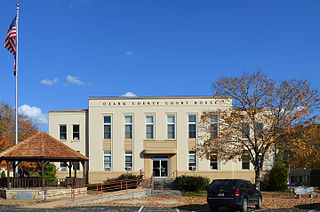
Ozark County is a county in the southern portion of the U.S. state of Missouri. As of the 2020 census, the population was 8,553. The largest city and county seat is Gainesville. The county was organized as Ozark County, named after the Ozark Mountains, on January 29, 1841. It was renamed Decatur County, after Commodore Stephen Decatur, from 1843 to 1845, after which the name Ozark County was restored.

<span class="mw-page-title-main">New Madrid County, Missouri</span> County in Missouri, United States

New Madrid County is a county located in the Bootheel of the U.S. state of Missouri. As of the 2020 census, the population was 16,434. The largest city is Portageville and county seat is New Madrid, located on the northern side of the Kentucky Bend in the Mississippi River, where it has formed an oxbow around an exclave of Fulton County, Kentucky. This feature has also been known as New Madrid Bend or Madrid Bend, for the city.

<span class="mw-page-title-main">Mississippi County, Missouri</span> County in Missouri, United States

Mississippi County is a county located in the Bootheel of the U.S. state of Missouri, with its eastern border formed by the Mississippi River. As of the 2020 census, the population was 12,577. The largest city and county seat is Charleston. The county was officially organized on February 14, 1845, and was named after the Mississippi River.

<span class="mw-page-title-main">Greene County, Missouri</span> County in Missouri, United States

Greene County is located in the southwest part of the U.S. state of Missouri. As of the 2020 census, its population was 298,915. making it the fourth most-populous county in Missouri.

<span class="mw-page-title-main">Crawford County, Missouri</span> County in Missouri, United States

Crawford County is a county located in the east-central portion of the U.S. state of Missouri. At the 2020 Census, the population was 23,056. Its county seat is Steelville. The county was organized in 1829 and is named after U.S. Senator William H. Crawford of Georgia.

<span class="mw-page-title-main">Christian County, Missouri</span> County in Missouri, United States

Christian County is located in the southwestern part of the U.S. state of Missouri. As of the 2020 census, its population was 88,842. Its county seat is Ozark. The county was organized in 1859 and is named after Christian County, Kentucky, which in turn is named for William Christian, a Kentucky soldier of the American Revolutionary War.

<span class="mw-page-title-main">Butler County, Missouri</span> County in Missouri, United States

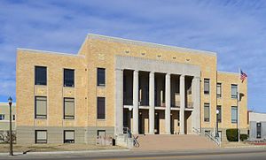
Butler County is a county located in the southeast Ozark Foothills Region in the U.S. state of Missouri. As of the 2020 Census, the county's population was 42,130. The largest city and county seat is Poplar Bluff. The county was officially organized from Wayne County on February 27, 1849, and is named after former U.S. Representative William O. Butler (D-Kentucky), who was also an unsuccessful candidate for Vice President of the United States. The first meeting in the Butler County Courthouse was held on June 18, 1849.

<span class="mw-page-title-main">Clarkton, Missouri</span> City in Missouri, United States

Clarkton is a city in Dunklin County, Missouri, United States. The population was 1,288 at the 2010 census. Clarkton is the oldest city in Dunklin County.

<span class="mw-page-title-main">Holcomb, Missouri</span> City in Missouri, United States

HolcombHAW-kəm is a city in Dunklin County, Missouri, United States. The population was 635 at the 2010 census.

<span class="mw-page-title-main">Malden, Missouri</span> City in Missouri, United States

Malden is a city in the northeast corner of Dunklin County, Missouri, United States, located near the intersection of Missouri Route 25 and U.S. Route 62. The population was 4,277 at the 2010 census. Malden is within Missouri's 8th congressional district.

<span class="mw-page-title-main">Senath, Missouri</span> City in Missouri, United States

Senath is a city in Dunklin County, Missouri, United States. The population was 1,767 at the 2010 census.

<span class="mw-page-title-main">Hornersville, Missouri</span> City in Missouri, United States

Hornersville is a city in Dunklin County, Missouri, United States, founded in 1840. The population was 537 at the 2020 census.

<span class="mw-page-title-main">Kennett, Missouri</span> City in Missouri, United States

Kennett is a city in and the county seat of Dunklin County, Missouri, United States. The city is located in the southeast corner of Missouri, 4 miles (6.4 km) east of Arkansas and 20 miles (32 km) from the Mississippi River. It had a population of 10,515 at the 2020 census. Kennett is the largest city in the Bootheel, a mostly agricultural area.

<span class="mw-page-title-main">Missouri Bootheel</span> Place

The Missouri Bootheel is a salient (protrusion) located in the southeasternmost part of the U.S. state of Missouri, extending south of 36°30′ north latitude, so called because its shape in relation to the rest of the state resembles the heel of a boot. Strictly speaking, it is composed of some or all of the counties of Dunklin, New Madrid, and Pemiscot. However, the term is locally used to refer to the entire southeastern lowlands of Missouri located within the Mississippi Embayment, which includes parts of Butler, Mississippi, Ripley, Scott, Stoddard and extreme southern portions of Cape Girardeau and Bollinger counties. The largest city in the region is Kennett.

<span class="mw-page-title-main">Missouri Route 108</span> Short state highway in the Missouri Bootheel

Route 108 is a short highway in the Bootheel of southeastern Missouri. Its eastern terminus is the Arkansas state line at Arkansas Highway 77, about six miles (10 km) south of Arbyrd, the only town on the route. Its western terminus is at U.S. Route 412 (US 412) about two miles (3 km) north of Arbyrd. Although signed as an east–west route, the route follows mostly north–south roadways. The route was designated in 1930, and was extended east in 1972.

<span class="mw-page-title-main">Missouri Route 25</span> State highway in Missouri

Route 25 is a highway in south-eastern Missouri. Its northern terminus is at Business Interstate 55/U.S. Route 61/Route 34 in Jackson. Its southern terminus is at U.S. Route 412/Route 84 in Kennett.

Missouri's 25th Senatorial District is one of 34 districts in the Missouri Senate. The district is currently represented by Republican Jason Bean.

References

  1. 1 2 "Explore Census Data". Data.census.gov. Retrieved March 20, 2022.
  2. "Find a County". National Association of Counties. Archived from the original on July 12, 2012. Retrieved June 7, 2011.
  3. Eaton, David Wolfe (1916). How Missouri Counties, Towns and Streams Were Named. The State Historical Society of Missouri. p. 165.
  4. Gannett, Henry (1905). The Origin of Certain Place Names in the United States. Govt. Print. Off. p. 110.
  5. "2010 Census Gazetteer Files". United States Census Bureau. August 22, 2012. Archived from the original on October 21, 2013. Retrieved November 15, 2014.
  6. "U.S. Decennial Census". United States Census Bureau. Retrieved November 15, 2014.
  7. "Historical Census Browser". University of Virginia Library. Retrieved November 15, 2014.
  8. "Population of Counties by Decennial Census: 1900 to 1990". United States Census Bureau. Retrieved November 15, 2014.
  9. "Census 2000 PHC-T-4. Ranking Tables for Counties: 1990 and 2000" (PDF). United States Census Bureau. Archived (PDF) from the original on March 27, 2010. Retrieved November 15, 2014.
  10. "State & County QuickFacts". United States Census Bureau. Archived from the original on June 7, 2011. Retrieved September 8, 2013.
  11. "U.S. Census website". United States Census Bureau . Retrieved January 31, 2008.
  12. "SELECTED ECONOMIC CHARACTERISTICS 2006-2010 American Community Survey 5-Year Estimates". U.S. Census Bureau. Archived from the original on February 12, 2020. Retrieved November 25, 2012.
  13. "Profile of General Population and Housing Characteristics: 2010 Demographic Profile Data". U.S. Census Bureau. Archived from the original on May 21, 2019. Retrieved November 25, 2012.
  14. "P2 HISPANIC OR LATINO, AND NOT HISPANIC OR LATINO BY RACE – 2020: DEC Redistricting Data (PL 94-171) – Dunklin County, Missouri".
  15. Breeding, Marshall. "Dunklin County Library". Libraries.org. Retrieved May 8, 2017.
  16. FAA Airport Form 5010 for TKX PDF . Federal Aviation Administration. Effective February 11, 2010.
  17. Healy, Jack (July 17, 2018). "It's 4 a.m. The Baby's Coming. But the Hospital Is 100 Miles Away". New York Times. Retrieved July 17, 2018.
  18. "Delta Dunklin Democrat | Newspaper serving Kennett, Missouri". Delta Dunklin Democrat. Retrieved January 12, 2019.
  19. "Missouri House of Representative - Members". www.house.mo.gov.
  20. "Our Campaigns - MO State House 150 Race - Nov 06, 2018". www.ourcampaigns.com.
  21. "Our Campaigns - MO State House 150 Race - Nov 08, 2016". www.ourcampaigns.com.
  22. "Our Campaigns - MO State House 150 Race - Nov 04, 2014". www.ourcampaigns.com.
  23. "Our Campaigns - MO State House 152 Race - Nov 06, 2018". www.ourcampaigns.com.
  24. "Missouri Senate – One Hundred First General Assembly – Missouri Senate".
  25. "Our Campaigns - MO State Senate 25 Race - Nov 08, 2016". www.ourcampaigns.com.
  26. "Our Campaigns - MO State Senate 25 Race - Nov 06, 2012". www.ourcampaigns.com.
  27. "Missouri Election Results". The New York Times . May 15, 2019. Retrieved March 20, 2022.
  28. "Missouri Election Results 2016". The New York Times . August 1, 2017. Retrieved March 20, 2022.
  29. "Missouri Election Results: Eighth House District – Election Results 2018". The New York Times . January 28, 2019. Retrieved March 20, 2022.
  30. "Missouri Eighth Congressional District Results: Jason Smith vs. Kathy Ellis". The New York Times . June 1, 2021 [2020-12-10]. Retrieved March 20, 2022.
  31. Leip, David. "Dave Leip's Atlas of U.S. Presidential Elections". uselectionatlas.org. Retrieved March 25, 2018.
  32. http://www.dddnews.com/story/1991176.html [ bare URL ]

36°16′N90°05′W / 36.27°N 90.09°W / 36.27; -90.09