Town and Country, Missouri

Last updated

Town and Country, Missouri
City of Town and Country
Town and Country, Missouri.jpg
From top left, left to right: Office building, Westminster Christian Academy, St. Louis Missouri Temple, Energizer Holdings headquarters
St. Louis County Missouri Incorporated and Unincorporated areas Town and Country Highlighted.svg
Location of Town and Country, Missouri
Coordinates: 38°37′54″N90°28′45″W / 38.63167°N 90.47917°W / 38.63167; -90.47917
Country United States
State Missouri
County St. Louis
Incorporated1975 (City)
Government
[1]
  TypeMayor-board of aldermen-city administrator
  MayorCharles Rehm Jr.
Area
[2]
  Total11.53 sq mi (29.86 km2)
  Land11.49 sq mi (29.76 km2)
  Water0.04 sq mi (0.09 km2)
Elevation
[3]
607 ft (185 m)
Population
 (2020)
  Total11,640
  Density1,012.97/sq mi (391.11/km2)
Time zone UTC-6 (Central (CST))
  Summer (DST) UTC-5 (CDT)
ZIP
63131, 63017
Area code 314
FIPS code 29-73618 [4]
GNIS feature ID2397043 [3]
Website City of Town and Country official website

Town and Country is a city in west [ broken anchor ] St. Louis County, Missouri, United States with a population of 11,640 as of the 2020 census. [5] It is home to Missouri Baptist Medical Center, (locally known as MoBap).

Contents

Town and Country has the highest median household income ($134,387 in 2009) [6] of any city in Missouri with a population over 10,000 and also has one of the highest median incomes of any city in the United States. The city is included in the St. Louis, MO-IL Metropolitan Statistical Area, and is home to Bellerive Country Club, which hosted the 1965 U.S. Open, [7] the 1992 PGA Championship, and the 2018 PGA Championship.

Geography

According to the United States Census Bureau, the city has a total area of 11.68 square miles (30.25 km2), all land. [8]

History

Town and Country was incorporated in 1950 as a village, and re-incorporated as a fourth-class city 25 years later. [9]

Demographics

Historical population
CensusPop.Note
1950 162
1960 1,440788.9%
1970 2,64583.7%
1980 3,18720.5%
1990 9,519198.7%
2000 10,89414.4%
2010 10,815−0.7%
2020 11,6407.6%
U.S. Decennial Census [10] [ failed verification ] 2020[ citation needed ]

2020 census

The 2020 United States census [11] counted 11,640 people, 4,033 households, and 3,333 families in Town and Country. The population density was 1,013.1 inhabitants per square mile (391.2/km2). There were 4,159 housing units at an average density of 362.0 per square mile (139.8/km2). The racial makeup was 77.04% (8,967) white, 2.65% (308) black or African-American, 0.08% (9) Native American or Alaska Native, 10.86% (1,264) Asian, 0.03% (3) Pacific Islander, 1.07% (124) from other races, and 8.29% (965) from two or more races. Hispanic or Latino of any race was 1.2% (138) of the population.

Of the 4,033 households, 30.5% had children under the age of 18; 79.9% were married couples living together; 11.5% had a female householder with no husband present. Of all households, 16.2% consisted of individuals and 11.6% had someone living alone who was 65 years of age or older. The average household size was 2.5 and the average family size was 2.8.

19.5% of the population was under the age of 18, 4.0% from 18 to 24, 14.3% from 25 to 44, 29.3% from 45 to 64, and 28.4% who were 65 years of age or older. The median age was 52.1 years. For every 100 females, the population had 99.2 males. For every 100 females ages 18 and older, there were 96.7 males.

The 2016-2020 5-year American Community Survey [12] estimates show that the median household income was $202,974 (with a margin of error of +/- $43,042) and the median family income was $250,000+ (+/- $**). Males had a median income of $186,875 (+/- $75,422) versus $42,983 (+/- $16,685) for females. The median income for those above 16 years old was $96,925 (+/- $24,776). Approximately, 2.6% of families and 4.3% of the population were below the poverty line, including 4.1% of those under the age of 18 and 3.5% of those ages 65 or over.

2010 census

At the 2010 census there were 10,815 people, 3,591 households, and 2,798 families living in the city. The population density was 925.9 inhabitants per square mile (357.5/km2). There were 3,871 housing units at an average density of 331.4 per square mile (128.0/km2). The racial makeup of the city was 87.8% White, 2.6% African American, 0.1% Native American, 7.5% Asian, 0.1% Pacific Islander, 0.4% from other races, and 1.6% from two or more races. Hispanic or Latino of any race were 1.7%. [13]

Of the 3,591 households 30.6% had children under the age of 18 living with them, 72.2% were married couples living together, 4.0% had a female householder with no husband present, 1.8% had a male householder with no wife present, and 22.1% were non-families. 17.9% of households were one person and 9.9% were one person aged 65 or older. The average household size was 2.66 and the average family size was 3.02.

The median age was 48.6 years. 21.9% of residents were under the age of 18; 10.1% were between the ages of 18 and 24; 12.3% were from 25 to 44; 32.4% were from 45 to 64; and 23.1% were 65 or older. The gender makeup of the city was 46.5% male and 53.5% female.

2000 census

At the 2000 census there were 10,894 people, 3,593 households, and 2,849 families living in the city. The population density was 916.8 inhabitants per square mile (354.0/km2). There were 3,741 housing units at an average density of 314.8 per square mile (121.5/km2). The racial makeup of the city was 90.16% White, 2.01% African American, 0.06% Native American, 6.33% Asian, 0.01% Pacific Islander, 0.23% from other races, and 1.20% from two or more races. Hispanic or Latino of any race were 1.07%. [4]

Of the 3,593 households 33.6% had children under the age of 18 living with them, 74.0% were married couples living together, 4.1% had a female householder with no husband present, and 20.7% were non-families. 18.7% of households were one person and 10.6% were one person aged 65 or older. The average household size was 2.69 and the average family size was 3.08.

The age distribution was 22.8% under the age of 18, 7.3% from 18 to 24, 16.9% from 25 to 44, 31.1% from 45 to 64, and 21.8% 65 or older. The median age was 47 years. For every 100 females, there were 87.7 males. For every 100 females age 18 and over, there were 81.5 males.

The median household income was $139,967 and the median family income was $167,875. Males had a median income of $100,000 versus $41,691 for females. The per capita income for the city was $69,347.

Economy

Energizer Holdings, [14] [ failed verification ] [15] Solutia and Savvis are headquartered in Town and Country. [16] [17] [18] [19]

Education

The public school district for most of Town and Country is the Parkway C-2 School District. [20] Parkway operates Mason Ridge Elementary School in Town and Country. [21] [22] Other portions are in the Kirkwood R-VII School District and the Ladue School District. [20]

Special School District of St. Louis County, a county-wide school district for disabled children, has the following in Town and Country: [21] its administrative offices, and Neuwoehner High School in Town and Country. [23]

Private schools: [21]

Tertiary facilities in Town and Country: [21]

Notable people

Related Research Articles

<span class="mw-page-title-main">Eureka, Missouri</span> A city in St. Louis County and Jefferson County, Missouri

Eureka is a city in St. Louis County and Jefferson County, Missouri, adjacent to Wildwood and Pacific. It is in the extreme southwest of the Greater St. Louis metro area. As of the 2020 census, the city had a population of 11,646. Since 1971, Eureka has been known as the home of the amusement park Six Flags St. Louis.

<span class="mw-page-title-main">Jackson, Missouri</span> City in Missouri, United States

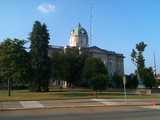
Jackson is a city in and the county seat of Cape Girardeau County, Missouri, United States. It is a principal city of the Cape Girardeau–Jackson, MO-IL Metropolitan Statistical Area. The population of Jackson was 15,481 at the 2020 census.

<span class="mw-page-title-main">Randolph, Missouri</span> City in Missouri, United States

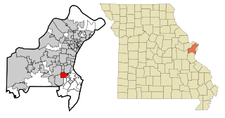
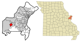
Randolph is a city in Clay County, Missouri, United States. The population was 57 at the 2020 census. It is completely surrounded by Kansas City and is a part of the Kansas City metropolitan area.

<span class="mw-page-title-main">Union, Missouri</span> City in Missouri, United States

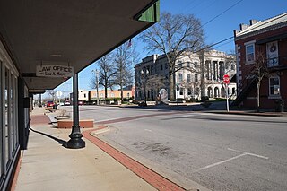
Union is a city in and the county seat of Franklin County, Missouri, United States. It is located on the Bourbeuse River, 50 miles (80 km) southwest of St. Louis. The population was 12,348 at the 2020 census.

<span class="mw-page-title-main">Washington, Missouri</span> City in the United States

Washington is a city on the south banks of the Missouri River, 50 miles west of St. Louis, Missouri, and the largest in Franklin County, Missouri, United States. The estimated population in July 2022 was 15,075, which is an increase of 3.97% since the 2020 U.S. census. It is notable for being the "corncob pipe capital of the world," with Missouri Meerschaum located on the riverfront.

<span class="mw-page-title-main">Festus, Missouri</span> City in Missouri, United States

Festus is a city situated in Jefferson County, Missouri, United States, and is also a suburb of St. Louis. It had a population of 12,706 individuals as of the 2020 census.

<span class="mw-page-title-main">Orrick, Missouri</span> Town in Missouri, United States

Orrick is a town in Ray County, Missouri, and part of the Kansas City metropolitan area within the United States. The population was 753 at the 2020 census.

<span class="mw-page-title-main">Augusta, Missouri</span> City in Missouri, United States

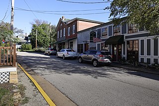
Augusta is a city in St. Charles County, Missouri, United States. The population was 270 at the 2020 census, up from 253 at the 2010 census. The city has wineries, antique shops, restaurants, B&B's, a wood shop, a glass studio, massage therapy, a historic museum, and The Augusta Brewery.

<span class="mw-page-title-main">Farmington, Missouri</span> City in Missouri, United States

Farmington is a city in St. Francois County located about 75 miles (121 km) southwest of St. Louis in the Lead Belt region in Missouri. As of the 2020 census, the population was 18,217. It is the county seat of St. Francois County. Farmington was established in 1822 as Murphy's Settlement, named for William Murphy of Kentucky, who first visited the site in 1798. When St. Francois County was organized, the town was briefly called St. Francois Court House and later renamed to Farmington.

<span class="mw-page-title-main">Ballwin, Missouri</span> City in Missouri, United States

Ballwin is a western suburb of St. Louis, located in St. Louis County, Missouri, United States. The population was 31,103 as of the 2020 census.

<span class="mw-page-title-main">Bellerive Acres, Missouri</span> City in Missouri, United States

Bellerive Acres is a northern suburban city in St. Louis County, Missouri, United States. The population was 188 at the 2010 census. In April, 2015, the residents voted to change the village of Bellerive to a fourth class city named Bellerive Acres.

<span class="mw-page-title-main">Beverly Hills, Missouri</span> City in Missouri, United States

Beverly Hills is a city in St. Louis County, Missouri, United States. As of the 2010 census, the city population was 574.

<span class="mw-page-title-main">Crestwood, Missouri</span> City in the United States

Crestwood is a city in south St. Louis County, Missouri, United States, part of the Metropolitan Statistical Area known as Greater St. Louis. The population was 11,912 at the 2010 census.

<span class="mw-page-title-main">Ellisville, Missouri</span> City in Missouri, United States

Ellisville is a city in St. Louis County, Missouri, United States, within Greater St. Louis. It is a western outer-ring suburb of St. Louis. The population was 9,985 at the 2020 census.

<span class="mw-page-title-main">Glendale, Missouri</span> City in Missouri, United States

Glendale is a city in St. Louis County, Missouri, United States. The population was 5,925 at the 2010 census.

<span class="mw-page-title-main">Lemay, Missouri</span> CDP in Missouri, United States

Lemay is a census-designated place (CDP) in south St. Louis County, Missouri, United States. The population was 16,645 at the 2010 census.

<span class="mw-page-title-main">Wildwood, Missouri</span> City in Missouri, United States

Wildwood is a city in St. Louis County, Missouri, United States. It is located in the far western portion of the county. As of the 2020 census, the population was 35,417. Wildwood is the home of the Al Foster Trail, and numerous other trails, parks, and reserves such as Rockwoods Reservation and Babler State Park.

<span class="mw-page-title-main">Dexter, Missouri</span> City in Missouri, United States

Dexter is a city in Stoddard County, Missouri, United States, founded in 1873. The population was 7,864 at the 2010 census.

<span class="mw-page-title-main">Nevada, Missouri</span> City in Missouri, United States

Nevada is a city in and the county seat of Vernon County, Missouri, United States. The population was 8,386 at the 2010 census, and 8,254 in the 2018 estimate. The local government has a council-manager model.

<span class="mw-page-title-main">Scott City, Missouri</span> City in Missouri, United States

Scott City is a city in Cape Girardeau and Scott counties in the U.S. state of Missouri. The population was 4,346 at the 2020 census. The Scott County portion of Scott City is part of the Sikeston Micropolitan Statistical Area, while the Cape Girardeau County portion is part of the Cape Girardeau–Jackson, MO-IL Metropolitan Statistical Area.

References

  1. Town and Country Guide
  2. "ArcGIS REST Services Directory". United States Census Bureau. Retrieved August 28, 2022.
  3. 1 2 U.S. Geological Survey Geographic Names Information System: Town and Country, Missouri
  4. 1 2 "U.S. Census website". United States Census Bureau . Retrieved January 31, 2008.
  5. "U.S. Census Bureau QuickFacts: Town and Country city, Missouri". www.census.gov. Retrieved February 20, 2024.
  6. City-Data.com
  7. "1965 U.S. Open". About.com. Retrieved May 6, 2015.
  8. "US Gazetteer files 2010". United States Census Bureau. Archived from the original on January 25, 2012. Retrieved July 8, 2012.
  9. Sutin, Phil (May 25, 2000). "TOWN AND COUNTRY VOTERS MAY DECIDE ON HOME-RULE CHARTER.(West Post)". HighBeam Research. Archived from the original on March 1, 2012. Retrieved February 11, 2017.
  10. "Census of Population and Housing". Census.gov. Retrieved June 4, 2015.
  11. "Explore Census Data". data.census.gov. Retrieved December 18, 2023.
  12. "Explore Census Data". data.census.gov. Retrieved December 18, 2023.
  13. "U.S. Census website". United States Census Bureau . Retrieved July 8, 2012.
  14. "Contact Energizer." Energizer Holdings. Retrieved on August 18, 2009.
  15. Volkmann, Kelsey. "Energizer to cut jobs as sales slump." St. Louis Business Journal . Tuesday July 28, 2009. Retrieved on August 18, 2009.
  16. "Town and Country, Mo.-Based Spin-Off Turns to Monsato for Financial Help." St. Louis Post-Dispatch . December 7, 2003. Retrieved on August 19, 2009.
  17. 1 2 3 "Zoning Map Archived 2010-02-02 at the Wayback Machine ." City of Town and Country. Retrieved on August 18, 2009.
  18. 1 2 "Town and Country city Archived 2011-11-25 at the Wayback Machine ." U.S. Census Bureau. Retrieved on August 18, 2009.
  19. "Global Offices Archived 2011-08-14 at the Wayback Machine ." Savvis. Retrieved on August 14, 2011. "Corporate Headquarters Savvis 1 Savvis Parkway Town & Country, MO 63017 "
  20. 1 2 "2020 CENSUS - SCHOOL DISTRICT REFERENCE MAP: St. Louis County, MO" (PDF). U.S. Census Bureau. Archived (PDF) from the original on July 22, 2022. Retrieved July 22, 2022. - Text list
  21. 1 2 3 4 "Subdivision Map". Town and Country, Missouri. Retrieved July 23, 2022.
  22. "Home". Mason Ridge Elementary School. Retrieved July 23, 2022. 715 South Mason Road Town & Country, MO 63141
  23. "All SSD Schools". Special School District of St. Louis County . Retrieved July 23, 2022. 12110 Clayton Road, Town & Country, MO 63131 - The address for Neuwoehner High: "12112 Clayton Road Town & Country, MO 63131"
  24. Kohler, Jeremy (March 18, 2013). "Michael J. Roarty dies; oversaw famous A-B ad campaigns". Saint Louis Post-Dispatch . Retrieved April 6, 2013.