Ellisville, Missouri

Last updated

Ellisville, Missouri
St. Louis County Missouri Incorporated and Unincorporated areas Ellisville Highlighted.svg
Location of Ellisville, Missouri
Coordinates: 38°35′23″N90°35′18″W / 38.58972°N 90.58833°W / 38.58972; -90.58833
Country United States
State Missouri
County St. Louis
Government
   Mayor Mike Roemerman
Area
[1]
  Total4.37 sq mi (11.31 km2)
  Land4.37 sq mi (11.31 km2)
  Water0.00 sq mi (0.00 km2)
Elevation
[2]
722 ft (220 m)
Population
 (2020)
  Total9,985
  Density2,287.51/sq mi (883.15/km2)
Time zone UTC-6 (Central (CST))
  Summer (DST) UTC-5 (CDT)
ZIP codes
63011, 63021, 63038
Area code 636
FIPS code 29-21898 [3]
GNIS feature ID2394664 [2]
Website www.ellisville.mo.us

Ellisville is a city in St. Louis County, Missouri, United States, within Greater St. Louis. It is a western outer-ring suburb of St. Louis. The population was 9,985 at the 2020 census. [4]

Contents

In 2009, Money magazine ranked Ellisville #25 on the annual Best Places to Live in America list. [5] The city is also currently home to an EPA Superfund site. [6]

History

Ellisville was settled by Captain James Harvey Ferris of Kentucky before 1837. He brought slaves with him when he settled his property south of Manchester and west of Kiefer Creek Road, and it was here the house that became known as the "Ellis House" was constructed. The bricks used for construction of the house were handmade by the slaves; it was also called the "Brick Place" for this reason. [7]

Captain Ferris sold the house to Vespasian Ellis, a newspaper editor in St. Louis. The Old School Democrat, the Native American Bulletin, the Washington Temperance Paper, and The Native American were among Ellis' work. In 1842, Ellis became the United States consul to Venezuela. He ran several ads in the Native American Bulletin in an effort to sell his Ellisville farm. As a result, it was sold to William A. Hereford in 1842 or 1843. Hereford was a Virginian and is credited with the naming of Ellisville after his former post office in Ellisville, Virginia. Hereford opened the first post office here on May 2, 1843. Some believe that the Ellis House itself actually served as the post office for a time. All historical accounts of the area give the same history, but none state clearly whether the town was named for Vespasian Ellis or by William Hereford for his Virginia post office.

Hereford sold to Samuel Wilson, and he sold to Major Clarkson of Kentucky for whom Clarkson Road is named. Major Clarkson sold to Captain Benjamin F. Hutchinson of Kentucky, a steamboat captain and the owner of at least three steamboats. Captain Hutchinson raised fine horses and planted extensive orchards, greatly improving the surrounding countryside. In 1868, Captain Hutchinson subdivided his farm into small lots.

Adam Doering purchased the brick house and a considerable portion of the land. John Henry William Rasch purchased the house about 1896 from the Doerings. The Ellisville House stood until 1969 when it was razed. [8]

Geography

According to the United States Census Bureau, the city has a total area of 4.39 square miles (11.37 km2), all land. [9]

Located 13 miles (21 km) west of the western city limits of St. Louis, Ellisville is located approximately 5 miles (8.0 km) south of Interstate 64, five miles north of Interstate 44 and 7 miles (11 km) west of Interstate 270. There are two primary arterial roads which bisect Ellisville: Missouri Route 100 (Manchester Road) and Missouri Route 340 (Clarkson Road). Ellisville is bordered by the city of Clarkson Valley to the north, the city of Ballwin to the east and southeast, unincorporated St. Louis County to the south, and the city of Wildwood to the west.

Demographics

Historical population
CensusPop.Note
1940 288
1950 628118.1%
1960 2,732335.0%
1970 4,68171.3%
1980 6,23333.2%
1990 7,54521.0%
2000 9,10420.7%
2010 9,1330.3%
2020 9,9859.3%
U.S. Decennial Census [10]

2020 census

The 2020 United States census [11] counted 9,985 people, 3,887 households, and 2,680 families in Ellisville. The population density was 2,284.9 per square mile (882.8/km2). There were 4,072 housing units at an average density of 931.8 per square mile (360.0/km2). The racial makeup was 82.48% (8,236) white, 2.5% (250) black or African-American, 0.15% (15) Native American, 7.31% (730) Asian, 0.0% (0) Pacific Islander, 1.21% (121) from other races, and 6.34% (633) from two or more races. Hispanic or Latino of any race was 6.6% (639) of the population.

Of the 3,887 households, 31.0% had children under the age of 18; 54.4% were married couples living together; 28.0% had a female householder with no husband present. Of all households, 28.8% consisted of individuals and 19.1% had someone living alone who was 65 years of age or older. The average household size was 2.5 and the average family size was 3.1.

21.9% of the population was under the age of 18, 6.3% from 18 to 24, 21.6% from 25 to 44, 25.2% from 45 to 64, and 22.7% who were 65 years of age or older. The median age was 44.4 years. For every 100 females, the population had 83.0 males. For every 100 females ages 18 and older, there were 85.3 males.

The 2016-2020 5-year American Community Survey [12] estimates show that the median household income was $78,961 (with a margin of error of +/- $6,910) and the median family income was $104,214 (+/- $15,693). Males had a median income of $53,276 (+/- $2,869) versus $34,523 (+/- $6,429) for females. The median income for those above 16 years old was $45,596 (+/- $5,363). Approximately, 1.4% of families and 2.9% of the population were below the poverty line, including 2.1% of those under the age of 18 and 3.1% of those ages 65 or over.

2010 census

As of the census [13] of 2010, there were 9,169 people, 3,669 households, and 2,469 families living in the city. The population density was 2,080.4 inhabitants per square mile (803.2/km2). There were 3,802 housing units at an average density of 866.1 per square mile (334.4/km2). The racial makeup of the city was 91.7% White, 1.9% African American, 0.1% Native American, 4.3% Asian, 0.6% from other races, and 1.4% from two or more races. Hispanic or Latino of any race were 2.4% of the population.

There were 3,621 households, of which 31.8% had children under the age of 18 living with them, 57.6% were married couples living together, 8.3% had a female householder with no husband present, 3.1% had a male householder with no wife present, and 31.0% were non-families. 27.5% of all households were made up of individuals, and 16.2% had someone living alone who was 65 years of age or older. The average household size was 2.47 and the average family size was 3.04.

The median age in the city was 44.7 years. 23.7% of residents were under the age of 18; 5.7% were between the ages of 18 and 24; 21% were from 25 to 44; 29.7% were from 45 to 64; and 19.8% were 65 years of age or older. The gender makeup of the city was 46.7% male and 53.3% female.

2000 census

As of the census [3] of 2000, there were 9,104 people, 3,209 households, and 2,486 families living in the city. The population density was 2,094.1 inhabitants per square mile (808.5/km2). There were 3,292 housing units at an average density of 757.2 per square mile (292.4/km2). The racial makeup of the city was 95.11% White, 1.58% African American, 0.11% Native American, 2.05% Asian, 0.38% from other races, and 0.76% from two or more races. Hispanic or Latino of any race were 1.16% of the population.

There were 3,209 households, out of which 39.7% had children under the age of 18 living with them, 66.9% were married couples living together, 8.2% had a female householder with no husband present, and 22.5% were non-families. 19.4% of all households were made up of individuals, and 9.3% had someone living alone who was 65 years of age or older. The average household size was 2.74 and the average family size was 3.16.

In the city the population was spread out, with 27.2% under the age of 18, 5.7% from 18 to 24, 28.7% from 25 to 44, 23.8% from 45 to 64, and 14.6% who were 65 years of age or older. The median age was 39 years. For every 100 females, there were 91.2 males. For every 100 females age 18 and over, there were 86.8 males.

The median income for a household in the city was $65,016, and the median income for a family was $74,375. Males had a median income of $55,224 versus $32,062 for females. The per capita income for the city was $27,379. About 1.9% of families and 3.5% of the population were below the poverty line, including 3.3% of those under age 18 and 5.4% of those age 65 or over.

Transportation

Highways and major roads

Missouri Route 340 (Clarkson Road) runs on north-south through much of Ellisville before turning into Kiefer Creek Road. Missouri Route 100 (Manchester Road) runs east-west through Ellisville.

Public transportation

Public transportation is provided by Metro and connects Ellisville to many other portions of Greater St. Louis by bus routes.

Attractions

The Ellisville Dog Park, [14] which opened in October 2012 is located in Bluebird Park.

Education

The St. Louis County Library Daniel Boone Branch and Asian Center is located in Ellisville. [15] [16] [17]

Public Schools

Ellisville Elementary, Ridge Meadows Elementary, and Crestview Middle are three schools in the Rockwood School District, and located in Ellisville. [18]

Private Schools

The following schools are within the city limits of Ellisville: St. Clare of Assisi and St. John Lutheran School [19]

Related Research Articles

<span class="mw-page-title-main">Ellisville, Illinois</span> Village in Illinois, United States

Ellisville is a village in Fulton County, Illinois, United States. The population was 87 at the 2020 census.

<span class="mw-page-title-main">Washington, Missouri</span> City in the United States

Washington is a city on the south banks of the Missouri River, 50 miles west of St. Louis, Missouri, and the largest in Franklin County, Missouri, United States. The estimated population in July 2022 was 15,075, which is an increase of 3.97% since the 2020 U.S. census. It is notable for being the "corncob pipe capital of the world," with Missouri Meerschaum located on the riverfront.

<span class="mw-page-title-main">Bellerive Acres, Missouri</span> City in Missouri, United States

Bellerive Acres is a northern suburban city in St. Louis County, Missouri, United States. The population was 188 at the 2010 census. In April, 2015, the residents voted to change the village of Bellerive to a fourth class city named Bellerive Acres.

<span class="mw-page-title-main">Beverly Hills, Missouri</span> City in Missouri, United States

Beverly Hills is a city in St. Louis County, Missouri, United States. As of the 2010 census, the city population was 574.

<span class="mw-page-title-main">Crestwood, Missouri</span> City in the United States

Crestwood is a city in south St. Louis County, Missouri, United States, part of the Metropolitan Statistical Area known as Greater St. Louis. The population was 11,912 at the 2010 census.

<span class="mw-page-title-main">Glendale, Missouri</span> City in Missouri, United States

Glendale is a city in St. Louis County, Missouri, United States. The population was 5,925 at the 2010 census.

<span class="mw-page-title-main">Green Park, Missouri</span> City in Missouri, United States

Green Park is a city in St. Louis County, Missouri, United States. The population was 2,622 at the 2010 census.

<span class="mw-page-title-main">Hazelwood, Missouri</span> City in Missouri, United States

Hazelwood is a city in St. Louis County, Missouri, within Greater St. Louis. It is a second-ring northern suburb of St. Louis. Based on the 2020 United States census, the city had a total population of 25,485. It is located north of St. Louis-Lambert International Airport and is situated on Interstates 270 and 170, as well as the much-traveled Lindbergh Boulevard and Highway 370.

<span class="mw-page-title-main">Lakeshire, Missouri</span> City in Missouri, United States

Lakeshire is a city in St. Louis County, Missouri, United States. The population was 1,432 at the 2010 census.

<span class="mw-page-title-main">Manchester, Missouri</span> City in Missouri, United States

Manchester is a city in St. Louis County, Missouri, United States. The population was 18,333 at the 2020 census.

<span class="mw-page-title-main">Oakland, Missouri</span> City in Missouri, United States

Oakland is a city in St. Louis County, Missouri, United States. The population was 1,381 at the 2010 census.

<span class="mw-page-title-main">Olivette, Missouri</span> City in Missouri, United States

Olivette is an inner-ring suburb of St. Louis, located in St. Louis County, Missouri, United States. The population was 8,504 at the 2020 census.

<span class="mw-page-title-main">Riverview, St. Louis County, Missouri</span> Village in Missouri, United States

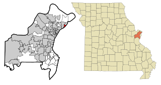
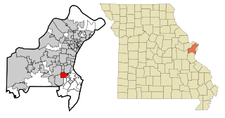
Riverview is a village in St. Louis County, Missouri, United States. The population was 2,397 at the 2020 census.

<span class="mw-page-title-main">Town and Country, Missouri</span> City in Missouri, United States

Town and Country is a city in west St. Louis County, Missouri, United States with a population of 11,640 as of the 2020 census. It is home to Missouri Baptist Medical Center,.

<span class="mw-page-title-main">Velda City, Missouri</span> City in Missouri, United States

Velda City is a city in St. Louis County, Missouri, United States. The population was 1,420 at the 2010 census.

<span class="mw-page-title-main">Wildwood, Missouri</span> City in Missouri, United States

Wildwood is a city in St. Louis County, Missouri, United States. It is located in the far western portion of the county. As of the 2020 census, the population was 35,417. Wildwood is the home of the Al Foster Trail, and numerous other trails, parks, and reserves such as Rockwoods Reservation and Babler State Park.

<span class="mw-page-title-main">Clarkson Valley, Missouri</span> City in Missouri, United States

Clarkson Valley is a city in St. Louis County, Missouri, United States. The population was 2,609 at the 2020 census.

<span class="mw-page-title-main">Moline Acres, Missouri</span> City in Missouri, United States

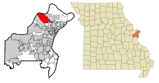
Moline Acres is a city in St. Louis County, Missouri, United States. The population was 2,442 at the 2010 census.

<span class="mw-page-title-main">St. Ann, Missouri</span> City in Missouri, United States

St. Ann or Saint Ann is a city in northwest St. Louis County, Missouri, United States. The population was 13,019 at the 2020 census.

<span class="mw-page-title-main">Ellisville Township, Fulton County, Illinois</span> Township in Illinois, United States

Ellisville Township is one of twenty-six townships in Fulton County, Illinois, USA. As of the 2020 census, its population was 135 and it contained 62 housing units.

References

  1. "ArcGIS REST Services Directory". United States Census Bureau. Retrieved August 28, 2022.
  2. 1 2 U.S. Geological Survey Geographic Names Information System: Ellisville, Missouri
  3. 1 2 "U.S. Census website". United States Census Bureau . Retrieved January 31, 2008.
  4. "United States Census Bureau" . Retrieved February 5, 2022.
  5. "Best Places to Live 2009". CNN.
  6. "ELLISVILLE SITE—ELLISVILLE, MO". EPA.
  7. "Archived copy". Archived from the original on August 18, 2014. Retrieved August 28, 2018.{{cite web}}: CS1 maint: archived copy as title (link)
  8. "404 File Not Found". Archived from the original on March 3, 2012. Retrieved August 28, 2018.{{cite web}}: Cite uses generic title (help)
  9. "US Gazetteer files 2010". United States Census Bureau. Archived from the original on January 25, 2012. Retrieved July 8, 2012.
  10. "Census of Population and Housing". Census.gov. Retrieved June 4, 2015.
  11. "Explore Census Data". data.census.gov. Retrieved December 17, 2023.
  12. "Explore Census Data". data.census.gov. Retrieved December 17, 2023.
  13. "U.S. Census website". United States Census Bureau . Retrieved July 8, 2012.
  14. http://ellisvilledogpark.com/%5B%5D
  15. "Daniel Boone Branch Archived 2009-08-21 at the Wayback Machine ." St. Louis County Library. Retrieved on August 18, 2009.
  16. "Asian Center Archived 2009-08-04 at the Wayback Machine ." St. Louis County Library. Retrieved on August 18, 2009.
  17. "Ellisville city, Missouri [ permanent dead link ]." U.S. Census Bureau. Retrieved on August 18, 2009.
  18. "Ellisville Elementary. Archived 2010-07-26 at the Wayback Machine
  19. "Schools | Ellisville, MO - Official Website". www.ellisville.mo.us. Retrieved August 29, 2019.