Hanley Hills, Missouri | |
---|---|
Coordinates: 38°41′08″N90°19′29″W / 38.68556°N 90.32472°W | |
Country | United States |
State | Missouri |
County | St. Louis |
Area | |
• Total | 0.36 sq mi (0.93 km2) |
• Land | 0.36 sq mi (0.93 km2) |
• Water | 0.00 sq mi (0.00 km2) |
Elevation | 558 ft (170 m) |
Population (2020) | |
• Total | 2,009 |
• Density | 5,596.10/sq mi (2,161.48/km2) |
Time zone | UTC-6 (Central (CST)) |
• Summer (DST) | UTC-5 (CDT) |
FIPS code | 29-30196 [3] |
GNIS feature ID | 2398239 [2] |
Website | www |
Hanley Hills is a village in St. Louis County, Missouri, United States. The population was 2,101 at the 2010 census. [4]
Hanley Hills is located at 38°41′11″N90°19′35″W / 38.68639°N 90.32639°W (38.686251, -90.326371). [5]
According to the United States Census Bureau, the village has a total area of 0.36 square miles (0.93 km2), all land. [6]
Census | Pop. | Note | %± |
---|---|---|---|
1950 | 2,219 | — | |
1960 | 3,308 | 49.1% | |
1970 | 2,801 | −15.3% | |
1980 | 2,439 | −12.9% | |
1990 | 2,325 | −4.7% | |
2000 | 2,124 | −8.6% | |
2010 | 2,101 | −1.1% | |
2020 | 2,009 | −4.4% | |
U.S. Decennial Census [7] |
As of the census [8] of 2010, there were 2,101 people, 867 households, and 571 families living in the village. The population density was 5,836.1 inhabitants per square mile (2,253.3/km2). There were 940 housing units at an average density of 2,611.1 per square mile (1,008.2/km2). The racial makeup of the village was 12.0% White, 85.3% African American, 0.1% Native American, 0.4% Asian, 0.3% from other races, and 1.9% from two or more races. Hispanic or Latino of any race were 1.3% of the population.
There were 867 households, of which 34.1% had children under the age of 18 living with them, 23.3% were married couples living together, 36.4% had a female householder with no husband present, 6.1% had a male householder with no wife present, and 34.1% were non-families. 29.3% of all households were made up of individuals, and 7.7% had someone living alone who was 65 years of age or older. The average household size was 2.42 and the average family size was 2.95.
The median age in the village was 38.1 years. 25.1% of residents were under the age of 18; 8.9% were between the ages of 18 and 24; 25.8% were from 25 to 44; 30.9% were from 45 to 64; and 9.2% were 65 years of age or older. The gender makeup of the village was 44.6% male and 55.4% female.
As of the census [3] of 2000, there were 2,124 people, 864 households, and 582 families living in the village. The population density was 5,721.9 inhabitants per square mile (2,209.2/km2). There were 939 housing units at an average density of 2,529.6 per square mile (976.7/km2). The racial makeup of the village was 21.61% White, 76.74% African American, 0.05% Native American, 0.14% Asian, 0.19% from other races, and 1.27% from two or more races. Hispanic or Latino of any race were 0.47% of the population.
There were 864 households, out of which 32.5% had children under the age of 18 living with them, 31.1% were married couples living together, 30.7% had a female householder with no husband present, and 32.6% were non-families. 28.8% of all households were made up of individuals, and 9.0% had someone living alone who was 65 years of age or older. The average household size was 2.46 and the average family size was 3.01.
In the village, the population was spread out, with 27.0% under the age of 18, 9.1% from 18 to 24, 30.0% from 25 to 44, 24.1% from 45 to 64, and 9.7% who were 65 years of age or older. The median age was 36 years. For every 100 females, there were 77.1 males. For every 100 females age 18 and over, there were 70.1 males.
The median income for a household in the village was $33,802, and the median income for a family was $37,368. Males had a median income of $30,833 versus $25,969 for females. The per capita income for the village was $15,906. About 6.3% of families and 9.3% of the population were below the poverty line, including 11.8% of those under age 18 and 7.7% of those age 65 or over.
Pinson is a city in Jefferson County near Birmingham, Alabama, United States, northwest of Center Point. As of the 2010 census, the population was 7,163.
Parkline is an unincorporated census-designated place on the Coeur d'Alene Reservation in Benewah County, Idaho, United States. The population was 80 at the 2010 census. Parkline was a city until it disincorporated in 2001.
Buda is a village in Bureau County, Illinois, United States. The population was 482 at the 2020 census. It is part of the Ottawa Micropolitan Statistical Area.
Eastborough is a city in Sedgwick County, Kansas, United States, and an enclave of the city of Wichita. As of the 2020 census, the population of the city was 756.
Hanley Falls is a city in Yellow Medicine County, Minnesota, United States. The population was 304 at the 2010 census.
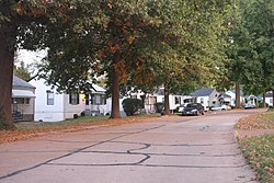
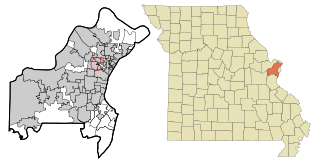
Brentwood is an inner-ring suburb of St. Louis, located in St. Louis County, Missouri, United States. The population was 8,233 at the 2020 census.
Grantwood Village is a town in St. Louis County, Missouri, United States. The population was 863 at the 2010 census.
Sycamore Hills is a village in St. Louis County, Missouri, United States. The population is 560 at the 2020 census.
York is a city in and the county seat of York County, Nebraska, United States. At the 2010 census, the city population was 7,766. It is the home of York University and the Nebraska Correctional Center for Women.
Bowersville is a village in Greene County, Ohio, United States. The population was 261 at the 2020 census. It is part of the Dayton Metropolitan Statistical Area.
Woodlawn is a village in Hamilton County, Ohio, United States. The population was 3,916 at the 2020 census.
Seven Fields is a borough in Butler County, Pennsylvania, United States. The population was 2,887 at the 2010 census, an increase from the figure of 1,986 tabulated in 2000.
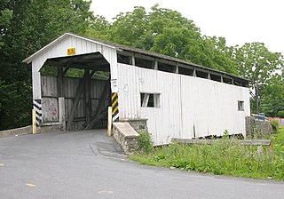
Ephrata Township is a township in northeastern Lancaster County, Pennsylvania, United States. The population was 10,391 at the 2020 census.
Morristown is a town in Lamoille County, Vermont, United States. As of the 2020 census, the population was 5,434. Morristown is the largest town by population in Lamoille County, and its central village of Morrisville serves as the county's main commercial center.
Bethlehem is a village in Ohio County, West Virginia, United States. It is part of the Wheeling, West Virginia Metropolitan Statistical Area. The population was 2,499 at the 2010 census.
Clearview is a village in Ohio County, West Virginia, United States. It is part of the Wheeling, West Virginia Metropolitan Statistical Area. The population was 565 at the 2010 census.
Sand Creek is a town in Dunn County, Wisconsin, United States. The population was 586 at the 2000 census. The unincorporated community of Sand Creek lies within the town, on the Red Cedar River.
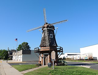
Cedar Grove is a village in Sheboygan County, Wisconsin, United States, within the Town of Holland. The population was 2,101 at the 2020 census. It is included in the Sheboygan, Wisconsin Metropolitan Statistical Area.
Elk Mountain is a town in Carbon County, Wyoming, United States. The population was 150 at the 2020 census. The town shares its name with a mountain 7 miles (11 km) to its southwest.
Monroe is a village in Orange County, New York, United States. The population was 9,343 at the 2020 census. It is part of the Poughkeepsie–Newburgh–Middletown, NY Metropolitan Statistical Area as well as the larger New York–Newark–Bridgeport, NY-NJ-CT-PA Combined Statistical Area. The community is not named after President James Monroe, but rather after an early 19th-century New York state senator.