Southwest City, Missouri

Last updated

Southwest City, Missouri
City limits of Southwest City, Missouri.jpg
Southwest City limits near the Arkansas/Oklahoma/Missouri tripoint
McDonald County Missouri Incorporated and Unincorporated areas South West City Highlighted.svg
Location in McDonald County and the state of Missouri
Coordinates: 36°30′59″N94°36′43″W / 36.51639°N 94.61194°W / 36.51639; -94.61194
Country United States
State Missouri
County McDonald
Area
[1]
  Total1.49 sq mi (3.85 km2)
  Land1.46 sq mi (3.79 km2)
  Water0.02 sq mi (0.06 km2)
Elevation
[2]
1,004 ft (306 m)
Population
 (2020) [3]
  Total922
  Density630.21/sq mi (243.25/km2)
Time zone UTC-6 (Central (CST))
  Summer (DST) UTC-5 (CDT)
ZIP code
64863
Area code 417
FIPS code 29-69230 [4]
GNIS feature ID2397669 [2]

Southwest City is a city in McDonald County, Missouri, United States. The population was 922 at the 2020 census. [3] It is located in the southwestern corner of the state of Missouri.

Contents

History

Southwest City was platted in 1870. [5] It was named from its location in the southwest corner of the county and state. [6]

Geography

Southwest City is bordered to the west by the state of Oklahoma, and the Arkansas state line is 13 mile (0.5 km) south of the city limits. Missouri Route 43 passes through the city as Main Street, leading north 13 miles (21 km) to Tiff City. To the south the highway becomes Arkansas Highway 43, leading 27 miles (43 km) to Siloam Springs. Missouri Route 90 leads east from Southwest City 8 miles (13 km) to Noel and 21 miles (34 km) to Jane.

According to the U.S. Census Bureau, Southwest City has a total area of 1.49 square miles (3.86 km2), of which 1.46 square miles (3.78 km2) are land and 0.02 square miles (0.05 km2), or 1.55%, are water. [1] Honey Creek runs through the city, flowing northwest to the Neosho River within the Lake o' the Cherokees in Oklahoma.

Demographics

Historical population
CensusPop.Note
1880 173
1890 707308.7%
1900 691−2.3%
1910 483−30.1%
1920 57719.5%
1930 484−16.1%
1940 5258.5%
1950 59513.3%
1960 504−15.3%
1970 453−10.1%
1980 51613.9%
1990 60016.3%
2000 85542.5%
2010 97013.5%
2020 922−4.9%
U.S. Decennial Census [7]

2010 census

As of the census [8] of 2010, there were 970 people, 319 households, and 225 families living in the city. The population density was 664.4 inhabitants per square mile (256.5/km2). There were 373 housing units at an average density of 255.5 per square mile (98.6/km2). The racial makeup of the city was 57.5% White, 0.1% African American, 3.7% Native American, 0.1% Asian, 1.6% Pacific Islander, 33.3% from other races, and 3.6% from two or more races. Hispanic or Latino of any race were 50.8% of the population.

There were 319 households, of which 47.3% had children under the age of 18 living with them, 47.0% were married couples living together, 15.0% had a female householder with no husband present, 8.5% had a male householder with no wife present, and 29.5% were non-families. 22.9% of all households were made up of individuals, and 8.7% had someone living alone who was 65 years of age or older. The average household size was 3.04 and the average family size was 3.53.

The median age in the city was 28.6 years. 34% of residents were under the age of 18; 10.1% were between the ages of 18 and 24; 29.4% were from 25 to 44; 18.8% were from 45 to 64; and 7.7% were 65 years of age or older. The gender makeup of the city was 51.8% male and 48.2% female.

2000 census

As of the census [4] of 2000, there were 905 people, 311 households, and 213 families living in the town. The population density was 613.6 inhabitants per square mile (236.9/km2). There were 340 housing units at an average density of 244.0 per square mile (94.2/km2). The racial makeup of the town was 71.81% White, 0.12% African American, 7.13% Native American, 0.23% Asian, 15.91% from other races, and 4.80% from two or more races. Hispanic or Latino of any race were 37.31% of the population.

There were 311 households, out of which 41.8% had children under the age of 18 living with them, 51.1% were married couples living together, 11.9% had a female householder with no husband present, and 31.2% were non-families. 26.4% of all households were made up of individuals, and 11.3% had someone living alone who was 65 years of age or older. The average household size was 2.75 and the average family size was 3.31.

In the town the population was spread out, with 33.8% under the age of 18, 10.2% from 18 to 24, 27.8% from 25 to 44, 17.1% from 45 to 64, and 11.1% who were 65 years of age or older. The median age was 29 years. For every 100 females, there were 94.8 males. For every 100 females age 18 and over, there were 86.2 males.

The median income for a household in the town was $22,721, and the median income for a family was $24,808. Males had a median income of $19,688 versus $19,107 for females. The per capita income for the town was $9,526. About 29.8% of families and 40.2% of the population were below the poverty line, including 51.9% of those under age 18 and 33.9% of those age 65 or over.

Related Research Articles

<span class="mw-page-title-main">Polo, Missouri</span> City in Missouri, United States

Polo is a city in southwest Caldwell County, Missouri, and is part of the Kansas City metropolitan area with the United States. The population was 509 at the 2020 census.

<span class="mw-page-title-main">Wyaconda, Missouri</span> City in Missouri, United States

Wyaconda is a city in Clark County, Missouri, United States. As of the 2020 census, its population was 214. The city was organized in 1888 and is named after a Siouan name for God or the Great Spirit. The first land purchased from the Santa Fe and Land Co. was in 1888.

<span class="mw-page-title-main">Otterville, Missouri</span> City in Missouri, United States

Otterville is a city in southwest Cooper County, Missouri, United States. The population was 454 at the 2010 census.

<span class="mw-page-title-main">Stewartsville, Missouri</span> City in Missouri, United States

Stewartsville is a city in southwest DeKalb County, Missouri, United States. The population was 733 at the 2020 census. The community is named for Robert M. Stewart, a former Missouri governor. It is part of the St. Joseph, MO–KS Metropolitan Statistical Area.

<span class="mw-page-title-main">Greenwood, Missouri</span> City in Missouri, United States

Greenwood is a city in Jackson and Cass counties in the U.S. state of Missouri. The population was 5,221 at the 2010 census. It is part of the Kansas City metropolitan area.

<span class="mw-page-title-main">Meadville, Missouri</span> City in Missouri, United States

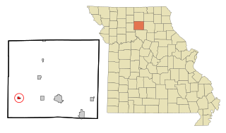
Meadville is a city in southwest Linn County, Missouri, United States. The population was 415 at the 2020 census.

<span class="mw-page-title-main">Marston, Missouri</span> City in Missouri, United States

Marston is a city in New Madrid County, Missouri, United States. The population was 503 at the 2010 census.

<span class="mw-page-title-main">Clearmont, Missouri</span> City in Missouri, United States

Clearmont is a city in northwest Nodaway County, Missouri, United States. The population was 158 at the 2020 census.

<span class="mw-page-title-main">Bolivar, Missouri</span> City in Missouri, United States

Bolivar is a city and county seat of Polk County, Missouri, United States.

<span class="mw-page-title-main">Bellerive Acres, Missouri</span> City in Missouri, United States

Bellerive Acres is a northern suburban city in St. Louis County, Missouri, United States. The population was 188 at the 2010 census. In April, 2015, the residents voted to change the village of Bellerive to a fourth class city named Bellerive Acres.

<span class="mw-page-title-main">Lakeshire, Missouri</span> City in Missouri, United States

Lakeshire is a city in St. Louis County, Missouri, United States. The population was 1,432 at the 2010 census.

<span class="mw-page-title-main">Manchester, Missouri</span> City in Missouri, United States

Manchester is a city in St. Louis County, Missouri, United States. The population was 18,333 at the 2020 census.

<span class="mw-page-title-main">Hurley, Missouri</span> City in Missouri, United States

Hurley is a city in Stone County, Missouri, United States. The population was 176 at the 2020 census. It is part of the Branson, Missouri Micropolitan Statistical Area.

<span class="mw-page-title-main">Bronaugh, Missouri</span> City in Missouri, United States

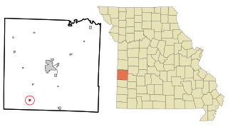
Bronaugh is a city in southwest Vernon County, Missouri, United States. The population was 249 at the 2010 census.

<span class="mw-page-title-main">Fordland, Missouri</span> City in Missouri, United States

Fordland is a city in southern Webster County, Missouri, United States. The population was 800 at the 2010 census. It is part of the Springfield, Missouri Metropolitan Statistical Area.

<span class="mw-page-title-main">Montgomery City, Missouri</span> City in Missouri, United States

Montgomery City is a city in and the county seat of Montgomery County, Missouri, United States. The population was 2,811 at the 2020 census.

<span class="mw-page-title-main">Moline Acres, Missouri</span> City in Missouri, United States

Moline Acres is a city in St. Louis County, Missouri, United States. The population was 2,442 at the 2010 census.

<span class="mw-page-title-main">Windsor, Missouri</span> City in Missouri, United States

Windsor is a city in Henry and Pettis counties, Missouri, United States. The population was 2,901 at the 2010 census.

<span class="mw-page-title-main">Belle, Missouri</span> City in Missouri, United States

Belle is a city in northeast Maries County and extending north into southeast Osage County in the U.S. state of Missouri. The population was 1,381 at the 2020 census, down from 1,545 in 2010.

<span class="mw-page-title-main">Dardenne Prairie, Missouri</span> Town in Missouri, United States

Dardenne Prairie is a city in St. Charles County, Missouri, United States. The population was 12,743 at the 2020 census.

References

  1. 1 2 "2023 U.S. Gazetteer Files: Missouri". United States Census Bureau. Retrieved March 28, 2024.
  2. 1 2 U.S. Geological Survey Geographic Names Information System: Southwest City, Missouri
  3. 1 2 "P1. Race – Southwest City city, Missouri: 2020 DEC Redistricting Data (PL 94-171)". U.S. Census Bureau. Retrieved March 28, 2024.
  4. 1 2 "U.S. Census website". United States Census Bureau . Retrieved January 31, 2008.
  5. "McDonald County Place Names, 1928–1945". The State Historical Society of Missouri. Archived from the original on June 24, 2016. Retrieved November 4, 2016.
  6. Eaton, David Wolfe (1916). How Missouri Counties, Towns and Streams Were Named. The State Historical Society of Missouri. pp.  190.
  7. "Census of Population and Housing". Census.gov. Retrieved June 4, 2015.
  8. "U.S. Census website". United States Census Bureau . Retrieved July 8, 2012.