Marthasville, Missouri

Last updated

Marthasville, Missouri
Marthasville Hardware Company 5-22-20 2.jpg
Warren County Missouri Incorporated and Unincorporated areas Marthasville Highlighted.svg
Location of Marthasville, Missouri
Coordinates: 38°37′50″N91°3′32″W / 38.63056°N 91.05889°W / 38.63056; -91.05889
Country United States
State Missouri
County Warren
Area
[1]
  Total0.86 sq mi (2.22 km2)
  Land0.85 sq mi (2.21 km2)
  Water0.00 sq mi (0.01 km2)
Elevation
561 ft (171 m)
Population
 (2020)
  Total1,245
  Density1,457.85/sq mi (562.84/km2)
Time zone UTC-6 (Central (CST))
  Summer (DST) UTC-5 (CDT)
ZIP code
63357
Area code 636
FIPS code 29-46424 [2]
GNIS feature ID0721912 [3]

Marthasville is a city in Warren County, Missouri, United States. The population was 1,136 at the 2010 census. The Katy Trail, a 240-mile long bike path, passes through Marthasville.

Contents

The original graves of Daniel Boone and his wife were located near there. [4] In 1845, Boone's remains were disinterred and moved to Kentucky for burial. Resentment in Missouri about the disinterment grew over the years, and a legend arose that Boone's remains never left Missouri.

Because of the many wineries from here east to Defiance, Marthasville is considered to mark one end of the "Missouri Weinstrasse".

History

A post office called Marthasville has been in operation since 1825. [5] The identity of namesake "Martha" is disputed. [6]

The Herman H. Fortmann Building, Marthasville Hardware Building, and Starke-Meinershagen-Boeke Rural Historic District are listed on the National Register of Historic Places. The Borgmann Mill and Flanders Callaway House were formerly listed. [7]

Geography

Marthasville is located at 38°37′50″N91°3′32″W / 38.63056°N 91.05889°W / 38.63056; -91.05889 (38.630458, -91.058864). [8] According to the United States Census Bureau, the city has a total area of 0.86 square miles (2.23 km2), of which 0.85 square miles (2.20 km2) is land and 0.01 square miles (0.03 km2) is water. [9]

Due to the rich soils and steep slopes, the landscape is highly suitable for viticulture, growing grapes and maintaining vineyards. Thus Marthasville became part of what is known as the Missouri "wine route".

Demographics

Historical population
CensusPop.Note
1860 76
1870 178134.2%
1930 394
1940 321−18.5%
1950 3478.1%
1960 339−2.3%
1970 41522.4%
1980 54330.8%
1990 67424.1%
2000 83724.2%
2010 1,13635.7%
2020 1,2459.6%
U.S. Decennial Census [10]

2010 census

As of the census [11] of 2010, there were 1,136 people, 431 households, and 310 families living in the city. There were 478 housing units at an average density of 562.4 per square mile (217.1/km2). The racial makeup of the city was 97.5% White, 0.2% African American, 0.3% Native American, 0.1% Asian, 0.7% from other races, and 1.2% from two or more races. Hispanic or Latino of any race were 1.8% of the population.

There were 431 households, of which 42.7% had children under the age of 18 living with them, 54.8% were married couples living together, 9.7% had a female householder with no husband present, 7.4% had a male householder with no wife present, and 28.1% were non-families. 23.9% of all households were made up of individuals, and 9.3% had someone living alone who was 65 years of age or older. The average household size was 2.64 and the average family size was 3.12.

The median age in the city was 31.1 years. 29.2% of residents were under the age of 18; 8% were between the ages of 18 and 24; 33.4% were from 25 to 44; 19.3% were from 45 to 64; and 10.1% were 65 years of age or older. The gender makeup of the city was 52.0% male and 48.0% female.

2000 census

As of the census [2] of 2000, there were 837 people, 321 households, and 230 families living in the city. There were 340 housing units at an average density of 406.0 per square mile (156.8/km2). The racial makeup of the city was 96.77% White, 1.08% African American, 0.48% Native American, 0.36% Asian, 0.36% from other races, and 0.96% from two or more races. Hispanic or Latino of any race were 0.36% of the population.

There were 321 households, out of which 40.8% had children under the age of 18 living with them, 60.1% were married couples living together, 6.9% had a female householder with no husband present, and 28.3% were non-families. 22.4% of all households were made up of individuals, and 8.4% had someone living alone who was 65 years of age or older. The average household size was 2.61 and the average family size was 3.09.

In the city the population was spread out, with 28.8% under the age of 18, 8.2% from 18 to 24, 36.3% from 25 to 44, 17.0% from 45 to 64, and 9.7% who were 65 years of age or older. The median age was 33 years. For every 100 females there were 105.7 males. For every 100 females age 18 and over, there were 100.7 males.

The median income for a household in the city was $41,141, and the median income for a family was $45,521. Males had a median income of $32,083 versus $21,875 for females. The per capita income for the city was $17,979. About 5.9% of families and 8.5% of the population were below the poverty line, including 9.9% of those under age 18 and 9.5% of those age 65 or over.

Related Research Articles

<span class="mw-page-title-main">Warren County, Missouri</span> County in Missouri, United States

Warren County is a county located in the eastern portion of the U.S. state of Missouri. As of the 2020 census, the population was 35,532. The county is located on the north side of the Missouri River. Its county seat is Warrenton. The county was established on January 5, 1833, and was named for General Joseph Warren, who died in the Battle of Bunker Hill during the American Revolutionary War.

<span class="mw-page-title-main">Boxholm, Iowa</span> City in Iowa, United States

Boxholm is a city in Grant Township, Boone County, Iowa, United States. The population was 181 at the 2020 census. It is part of the Boone, Iowa Micropolitan Statistical Area, which is a part of the larger Ames-Boone, Iowa Combined Statistical Area.

<span class="mw-page-title-main">Granger, Iowa</span> City in Iowa, United States

Granger is a city in Dallas and Polk counties in the U.S. state of Iowa. The population was 1,654 at the time of the 2020 census, up 184% from 583 in 2000. It is part of the Des Moines–West Des Moines Metropolitan Statistical Area.

<span class="mw-page-title-main">Watson, Missouri</span> Village in Missouri

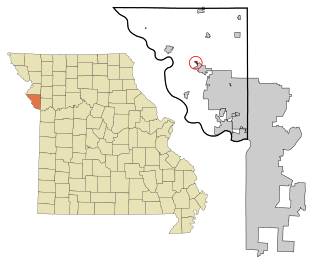
Watson is a village in Nishnabotna Township, Atchison County, Missouri, United States. The population was 61 at the 2020 census. It is the westernmost settlement in the state of Missouri, about 120 miles northwest of Kansas City.

<span class="mw-page-title-main">Ashland, Missouri</span> City in Missouri, United States

Ashland is a city in Boone County, Missouri, United States. Ashland is part of the Columbia, Missouri Metropolitan Statistical Area. The population was 4,747 at the 2020 census.

<span class="mw-page-title-main">Rocheport, Missouri</span> City in Missouri, United States

Rocheport is a city in Boone County, Missouri, United States. It is part of the Columbia, Missouri Metropolitan Statistical Area. The population was 239 at the 2010 census. Rocheport includes the Rocheport Historic District, an area with buildings dating from 1830 and which is listed on the National Register of Historic Places.

<span class="mw-page-title-main">Bosworth, Missouri</span> City in Missouri, United States

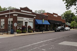
Bosworth is a city in Carroll County, Missouri, United States. The population was 213 at the 2020 U.S. Census.

<span class="mw-page-title-main">Ash Grove, Missouri</span> City in Missouri, United States

Ash Grove is a city in Greene County, Missouri, United States. The population was 1,512 at the 2020 census. It is part of the Springfield, Missouri Metropolitan Statistical Area.

<span class="mw-page-title-main">Troy, Missouri</span> City in Missouri, US

Troy is a city in Lincoln County, Missouri, United States. As of 2019, the estimated population was 12,820. It is the county seat of Lincoln County. Troy is an exurb of St. Louis, and is part of the St. Louis Metropolitan Statistical Area.

<span class="mw-page-title-main">Homestown, Missouri</span> City in Missouri, United States

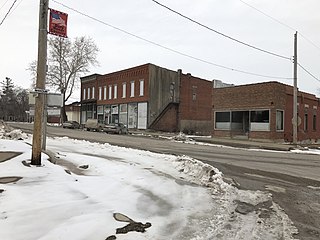
Homestown is a city in Pemiscot County, Missouri, United States. The population was 73 at the 2020 census.

<span class="mw-page-title-main">Tracy, Missouri</span> City in Missouri, United States

Tracy is a city in Platte County, Missouri within the United States, located along the Platte River. The population was 269 at the 2020 census. The city is part of the Kansas City metropolitan area.

<span class="mw-page-title-main">Crystal Lake Park, Missouri</span> City in Missouri, United States

Crystal Lake Park is a Missouri Class 4 city in St. Louis County, Missouri, United States. The population was 508 at the 2020 census.

<span class="mw-page-title-main">Ellisville, Missouri</span> City in Missouri, United States

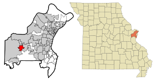
Ellisville is a city in St. Louis County, Missouri, United States, within Greater St. Louis. It is a western outer-ring suburb of St. Louis. The population was 9,985 at the 2020 census.

<span class="mw-page-title-main">Greendale, Missouri</span> City in Missouri, United States

Greendale is a city in St. Louis County, Missouri, United States. The population was 651 at the 2010 census.

<span class="mw-page-title-main">Cedar Rapids, Nebraska</span> Village in Nebraska, United States

Cedar Rapids is a village in Boone County, Nebraska, United States. The population was 382 at the 2010 census.

<span class="mw-page-title-main">Crystal City, Missouri</span> City in Missouri, United States

Crystal City is a city in eastern Jefferson County, Missouri, United States and is a suburb of St. Louis. The population was 4,855 at the 2010 census. It was 4,740 at the 2020 census.

<span class="mw-page-title-main">Moline Acres, Missouri</span> City in Missouri, United States

Moline Acres is a city in St. Louis County, Missouri, United States. The population was 2,442 at the 2010 census.

<span class="mw-page-title-main">Reeds Spring, Missouri</span> City in Missouri, United States

Reeds Spring is a city in Stone County, Missouri, United States. The population was 1,136 at the 2020 census.

<span class="mw-page-title-main">West Clarkston-Highland, Washington</span> CDP in Washington, United States

West Clarkston-Highland is a census-designated place (CDP) in Asotin County, Washington, United States. It is part of the Lewiston, ID-WA Metropolitan Statistical Area. The population was 5,488 at the 2020 census.

<span class="mw-page-title-main">Madison, West Virginia</span> City in West Virginia, United States

Madison is a city and former coal town in Boone County, West Virginia, United States. The population was 2,911 at the 2020 census. It is the county seat of Boone County.

References

  1. "ArcGIS REST Services Directory". United States Census Bureau. Retrieved August 28, 2022.
  2. 1 2 "U.S. Census website". United States Census Bureau . Retrieved January 31, 2008.
  3. "US Board on Geographic Names". United States Geological Survey. October 25, 2007. Retrieved January 31, 2008.
  4. Eaton, David Wolfe (1918). How Missouri Counties, Towns and Streams Were Named. The State Historical Society of Missouri. p. 369.
  5. "Post Offices". Jim Forte Postal History. Retrieved December 30, 2016.
  6. "Warren County Place Names, 1928–1945". The State Historical Society of Missouri. Archived from the original on June 24, 2016. Retrieved December 30, 2016.
  7. "National Register Information System". National Register of Historic Places . National Park Service. July 9, 2010.
  8. "US Gazetteer files: 2010, 2000, and 1990". United States Census Bureau. February 12, 2011. Retrieved April 23, 2011.
  9. "US Gazetteer files 2010". United States Census Bureau. Archived from the original on July 2, 2012. Retrieved July 8, 2012.
  10. "Census of Population and Housing". Census.gov. Retrieved June 4, 2015.
  11. "U.S. Census website". United States Census Bureau . Retrieved July 8, 2012.