Adams County is the westernmost county of the U.S. state of Illinois. As of the 2010 census, the population was 67,103. Its county seat is Quincy.

Sangamon County is a county located in the center of the U.S. state of Illinois. According to the 2010 census, it had a population of 197,465. Its county seat is Springfield, the state capital.

LaSalle County is located in the North Central region of the U.S. state of Illinois; it has an estimated population of 111,241 as of 2014 and its county seat and largest city is Ottawa.

Franklin County is a county located in the U.S. state of Illinois. According to the 2010 census, it has a population of 39,561. Its county seat is Benton. It is located in the southern portion of Illinois known locally as "Little Egypt".

Coles County is a county located in the U.S. state of Illinois. As of the 2010 census, the population was 53,873. Its county seat is Charleston, which is also the home of Eastern Illinois University.

Carroll County is a county located in the U.S. state of Illinois. As of the 2010 census, the population was 15,387. Its county seat is Mount Carroll.

Calhoun County is a county in the U.S. state of Illinois. As of the 2010 census, the population was 5,089, making it Illinois’ third-least populous county. Its county seat and biggest community is Hardin, with a population of slightly less than 1,000. Its smallest community is Hamburg, with a population of 123. Calhoun County is at the tip of the peninsula formed by the courses of the Mississippi and Illinois rivers above their confluence and is almost completely surrounded by water. Calhoun County is sparsely populated; it has just five municipalities, all of them villages.

Brown County is a county located in the U.S. state of Illinois. As of the 2010 census, the population was 6,937. Its county seat is Mount Sterling.

Bond County is a county located in the U.S. state of Illinois. As of the 2010 census, the population was 17,768. Its county seat is Greenville.

The University of Illinois at Urbana–Champaign is a public research university in Illinois and the flagship institution of the University of Illinois System. Founded in 1867 as a land-grant institution, its campus is located in the twin cities of Champaign and Urbana.
Lewis and Clark Community College is a community college in Godfrey, Illinois. It serves approximately 15,000 credit and non-credit students annually. The college has nine locations located throughout the St. Louis Metro East, including a campus and humanities center in Edwardsville, Illinois; community education centers in Alton, Illinois, Carlinville, Illinois and Jerseyville, Illinois; a training center in Bethalto, Illinois; a river research center in East Alton, Illinois; and a location at the East St. Louis Higher Education Center in East St. Louis, Illinois. Lewis and Clark has career and transfer study options. The college also offers personal enrichment programming for adults and children, as well as corporate and safety training options for professionals.
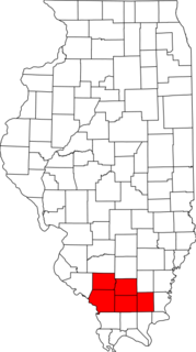
Metro Lakeland is a name that was coined in the 1960s for an area of southern Illinois that is centered on the intersections of Interstate 57, Interstate 24, and Illinois Route 13 — a four-lane east-west highway connecting the communities of Murphysboro, Carbondale, Carterville, Herrin, Marion, and Harrisburg. Metro Lakeland was defined as Jackson, Williamson, Franklin, Saline, and Perry counties, with a combined population of approximately 210,000. Carbondale, Herrin, and Marion are the key urban areas, with a combined city-proper population of over 65,000 Carbondale, the site of Southern Illinois University, is the region's largest city. Metro Lakeland is about 88 miles (142 km) southeast of St. Louis, Missouri, or 120 miles (190 km) by Interstate highway.

Elk Prairie Township is one of sixteen townships in Jefferson County, Illinois, USA. As of the 2010 census, its population was 725 and it contained 350 housing units.

St. Charles is a city in DuPage and Kane counties in the U.S. state of Illinois. It lies roughly 40 miles (64 km) west of Chicago on Illinois Route 64. As of the 2010 census the population was 32,974, and as of 2017 the population had dropped to an estimated 32,714. The official city slogan is "Pride of the Fox", after the Fox River that runs through the center of town. St. Charles is part of a tri-city area along with Geneva and Batavia, all western suburbs of similar size and relative socioeconomic condition.

Rosecrans is an unincorporated community along Rosecrans Road just west of U.S. Route 41 in northern Lake County, Illinois, 2.0 miles (3.2 km) south of the Wisconsin state line and 7.8 miles (12.6 km) west of Lake Michigan. The community is named for American Civil War General William Starke Rosecrans. The business district is at the intersection of IL 173 and US 41, east of the residential community.
Poverty Ridge is an unincorporated community in Fulton County, Illinois, United States, about eleven miles northwest of Lewistown. Its elevation is 633 feet (202 m), and it is located at 40°27′43″N90°20′27″W. The community is named for a line of hills near Seville, which likewise is named Poverty Ridge.

Bigneck, also known as Big Neck, is an unincorporated community in Keene Township, Adams County, Illinois, United States. Bigneck is located 7.7 miles (12.4 km) west-northwest of Golden. The community is served by Illinois Route 61. There remain about two houses in the community and no businesses. Bigneck once had a post office which is now defunct. A. Otis Arnold (1878–1941), Illinois businessman and politician, was born near Bigneck, in Adams County.
Donkville is an unincorporated community in Madison County, in the U.S. state of Illinois.
East Hannibal is an unincorporated community in Pike County, in the U.S. state of Illinois. The community was named for its location east of Hannibal, Missouri.
Hendrix is an unincorporated community in McLean County, in the U.S. state of Illinois.