
Jefferson County is a county located in the U.S. state of Washington. As of the 2010 census, the population was 29,872. The county seat and only incorporated city is Port Townsend. The county is named for Thomas Jefferson.

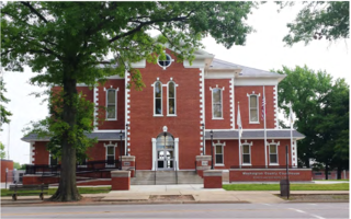
Jefferson County is located in the eastern portion of the state of Missouri. It is a part of the St. Louis Metropolitan Area. As of the 2010 census, the population was 218,733, making it the sixth-most populous county in Missouri. Its county seat is Hillsboro. The county was organized in 1818 and named in honor of former president Thomas Jefferson.

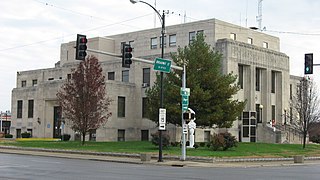
Cole County is a county in the central part of the U.S. state of Missouri. As of the 2010 census, the population was 75,990. Its county seat and largest city is Jefferson City, the state capital. The county was organized November 16, 1820 and named after pioneer Captain Stephen Cole, an Indian fighter and pioneer settler, who built Cole's Fort in Boonville.
Washington County is a county located in the U.S. state of Illinois. According to the 2010 census, it had a population of 14,716. Its county seat is Nashville. It is located in the southern portion of Illinois known locally as "Little Egypt".

Monroe County is a county located in the U.S. state of Illinois. According to the 2010 census, it had a population of 32,957. Its county seat and largest city is Waterloo.

Marion County is a county located in the U.S. state of Illinois. According to the 2010 census, it had a population of 39,437. Its county seat is Salem.
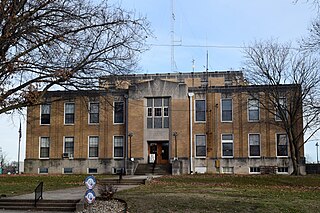
Jefferson County is a county located in the southern part of the U.S. state of Illinois. According to the 2010 census, it has a population of 38,827. The county seat is Mount Vernon.
Hamilton County is a county located in the U.S. state of Illinois. According to the 2010 census, it has a population of 8,457. Its county seat is McLeansboro. It is located in the southern portion of the state known locally as "Little Egypt".

Franklin County is a county located in the U.S. state of Illinois. According to the 2010 census, it has a population of 39,561. Its county seat is Benton. It is located in the southern portion of Illinois known locally as "Little Egypt".

The Northwest Territory in the United States was formed after the American Revolutionary War, and was known formally as the Territory Northwest of the River Ohio. It was the initial post-colonial Territory of the United States and encompassed most of pre-war British colonial territory west of the Appalachian mountains north of the Ohio River. It included all the land west of Pennsylvania, northwest of the Ohio River and east of the Mississippi River below the Great Lakes. It spanned all or large parts of six eventual U.S. States. It was created as a Territory by the Northwest Ordinance July 13, 1787, reduced to Ohio, eastern Michigan and a sliver of southeastern Indiana with the formation of Indiana Territory July 4, 1800, and ceased to exist March 1, 1803, when the southeastern portion of the territory was admitted to the Union as the state of Ohio, and the remainder attached to Indiana Territory.

The Rock River is a tributary of the Mississippi River, approximately 299 miles (481 km) long, in the U.S. states of Wisconsin and Illinois. The river was known as the Sinnissippi to Sauk and Fox Indians; the name means "rocky waters".
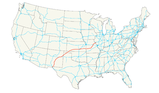
U.S. Route 54 is an east–west United States highway that runs northeast–southwest for 1,197 miles (2,115 km) from Griggsville, Illinois to El Paso, Texas. It enters and leaves Texas twice. The Union Pacific Railroad's Tucumcari Line runs parallel to US-54 from El Paso to Pratt, Kansas, which comprises about two-thirds of the route.

Takilma is an unincorporated community and census-designated place (CDP) in Josephine County, Oregon, United States, 10 miles (16 km) south of Cave Junction. It is located on the East Fork Illinois River, about a mile southeast of the ghost town of Waldo. As of the 2010 census, it had a population of 378.

Harmony is an unincorporated community in Jefferson County, Illinois, United States. Harmony is 8.5 miles (13.7 km) northeast of Mount Vernon.
Jefferson Township is a former civil township in Cook County, Illinois, United States that existed as a separate municipality from 1850 until 1889 when it was annexed into the city of Chicago. Its borders were Devon Avenue on the north, Harlem Avenue on the west, Western Avenue to the east, and North Avenue to the south. This region comprised most of what is now known as the Chicago's Northwest Side including the entirety of the following community areas: Jefferson Park, North Park, Albany Park, Irving Park, Avondale, Hermosa, Belmont-Cragin, Montclare, Portage Park, as well as parts of Forest Glen, West Ridge, Lincoln Square, North Center, Logan Square, West Town, Humboldt Park, Austin, Dunning, the suburb of Norridge, the suburb of Harwood Heights, and Norwood Park.
Dareville is an unincorporated community in Jefferson County, in the U.S. state of Illinois.
Drivers is an unincorporated community in Jefferson County, in the U.S. state of Illinois.
McMinns Summit is an unincorporated community in Jefferson County, in the U.S. state of Pennsylvania.


