
Stark County is in Illinois. According to the 2010 census, it had a population of 5,994. Its county seat is Toulon.

Ashton is a village in Lee County, Illinois, United States. The population was 972 at the 2010 census, down from 1,142 in 2000.
Williamsville is a village in Sangamon County, Illinois, United States. The population was 1,476 at the 2010 census, and 1,491 at a 2018 estimate. It is part of the Springfield, Illinois Metropolitan Statistical Area.

Bradford is a village in Stark County, Illinois, United States. The population was 768 at the 2010 census. Bradford is part of the Peoria, Illinois Metropolitan Statistical Area.
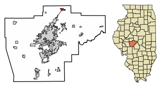
Wyoming is a city in Stark County, Illinois, United States. The population was 1,429 at the 2010 census, up from 1,424 in 2000. It is the headquarters of the Rock Island Trail State Park. Wyoming is part of the Peoria, Illinois Metropolitan Statistical Area. The former CB&Q Railroad depot in town is the Rock Island Trail State Park's headquarters.

Bright is an unincorporated community and census-designated place (CDP) in Dearborn County, Indiana, United States. The population was 5,814 at the 2020 census.

Randalia is a city in Fayette County, Iowa, United States. The population was 51 at the time of the 2020 census.

Pittsford Township is a civil township of Hillsdale County in the U.S. state of Michigan. The population was 1,577 at the 2020 census.

Newtonia is a village in Newton County, Missouri, United States. The population was 199 at the 2010 census. It is part of the Joplin, Missouri Metropolitan Statistical Area. Newtonia was the site of the Battles of Newtonia during the American Civil War. The village contains some Antebellum houses, such as the Mathew H. Ritchey House, as well as a cemetery for Civil War dead. It is a farming community and is immediately adjacent to Stark City, Missouri.

Westgate is an unincorporated census-designated place (CDP) in Palm Beach County, Florida, United States. The population was 8,435 at the 2020 census. Prior to the 2010 census, it was listed as the Westgate-Belvedere Homes CDP.

Franklin is a city in Franklin County, Nebraska, United States. The population was 1,000 at the 2010 census. It is the county seat of Franklin County.

Ashton is a village in Sherman County, Nebraska, United States. The population was 194 at the 2010 census.
Adams Center is a hamlet and census-designated place (CDP) in the town of Adams in Jefferson County, New York, United States. The population was 1,492 during the 2020 decennial census.

Elm City is a town in Wilson County, North Carolina, United States. The population was 1,298 in 2010.
Shippenville is a borough in Clarion County, Pennsylvania, United States. The population was 446 at the 2020 census.

Platea is a borough in Erie County, Pennsylvania, United States. The population was 443 at the 2020 census.

Reynoldsville is a borough in Jefferson County, Pennsylvania, United States. It is 73 miles (117 km) northeast of Pittsburgh in a productive soft coal region. The population was 2,759 at the 2010 census.

Thompson is a borough in Susquehanna County, Pennsylvania, United States. The population was 255 at the 2020 census.

City View, a former incorporated city, is now a census-designated place (CDP) in Greenville County, South Carolina, United States. The population was 1,345 at the 2010 census, up from 1,254 in 2000. It is part of the Greenville–Mauldin–Easley Metropolitan Statistical Area.
Effie is an unorganized territory in Itasca County, Minnesota, United States. The population was 203 at the 2010 census.


