Unity, Illinois

Last updated

Unity, Illinois
USA Illinois location map.svg
Red pog.svg
Unity, Illinois
Usa edcp location map.svg
Red pog.svg
Unity, Illinois
Coordinates: 37°08′59″N89°16′22″W / 37.14972°N 89.27278°W / 37.14972; -89.27278
Country United States
State Illinois
County Alexander
Area
[1]
  Total0.70 sq mi (1.82 km2)
  Land0.70 sq mi (1.82 km2)
  Water0.00 sq mi (0.00 km2)
Elevation
335 ft (102 m)
Population
 (2020)
  Total98
  Density139.80/sq mi (53.95/km2)
Time zone UTC-6 (Central (CST))
  Summer (DST) UTC-5 (CDT)
Area code 618
GNIS feature ID425589 [2]

Unity, also known as Hodges Park Station, is an unincorporated community and census-designated place in Alexander County, Illinois, United States. Illinois Route 127 passes by Unity south of Tamms. The population as of the 2020 census was 98. [3]

Contents

Geography

According to the 2021 census gazetteer files, Unity has a total area of 0.70 square miles (1.81 km2), all land. [4]

Demographics

As of the 2020 census [3] there were 98 people, 25 households, and 13 families residing in the CDP. The population density was 139.80 inhabitants per square mile (53.98/km2). There were 54 housing units at an average density of 77.03 per square mile (29.74/km2). The racial makeup of the CDP was 17.35% White, 77.55% African American, 0.00% Native American, 0.00% Asian, 0.00% Pacific Islander, 0.00% from other races, and 5.10% from two or more races. Hispanic or Latino of any race were 5.10% of the population.

There were 25 households, none with children under the age of 18 living with them. 52.00% of households were married couples living together. 48.00% of all households were made up of individuals, and 20.00% had someone living alone who was 65 years of age or older. The average household size was 3.85 and the average family size was 2.48.

The CDP's age distribution consisted of none under the age of 18, none from 18 to 24, 25.8% from 25 to 44, 11.3% from 45 to 64, and 62.9% who were 65 years of age or older. The median age was 66.5 years. For every 100 females, there were 148.0 males. For every 100 females age 18 and over, there were 148.0 males.

The median income for a household in the CDP was $59,464; the per capita income was $30,961. No families, and 11.3% of the population were below the poverty line.

Historical population
CensusPop.Note
2020 98
U.S. Decennial Census [5]

2020 census

Unity CDP, Illinois – Racial and ethnic composition
Note: the US Census treats Hispanic/Latino as an ethnic category. This table excludes Latinos from the racial categories and assigns them to a separate category. Hispanics/Latinos may be of any race.
Race / Ethnicity (NH = Non-Hispanic)Pop 2020 [6] % 2020
White alone (NH)1414.29%
Black or African American alone (NH)7576.53%
Native American or Alaska Native alone (NH)00.00%
Asian alone (NH)00.00%
Pacific Islander alone (NH)00.00%
Some Other Race alone (NH)00.00%
Mixed Race or Multi-Racial (NH)44.08%
Hispanic or Latino (any race)55.10%
Total98100.00%

Education

Residents are zoned to the Egyptian School District. [7]

Related Research Articles

<span class="mw-page-title-main">McDonald Chapel, Alabama</span> CDP in Alabama, United States

McDonald Chapel is a census-designated place in Jefferson County, Alabama, United States. It is northeast of the Birmingham suburb of Pleasant Grove. At the 2020 census, the population was 739. Large portions of this area were damaged by violent tornadoes in 1956, 1998, and 2011. The 1998 tornado was rated F5 on the Fujita scale.

<span class="mw-page-title-main">Rock Creek, Alabama</span> CDP in Alabama, United States

Rock Creek is a census-designated place in Jefferson County, Alabama, United States. Its location is northwest of Hueytown. At the 2020 census, the population was 1,471. This area was damaged by an F5 tornado on April 8, 1998. An EF2 tornado struck northwest from here on January 23, 2012.

<span class="mw-page-title-main">Ferry, Alaska</span> Census-designated place in Alaska, United States

Ferry is a census-designated place (CDP) in Denali Borough, Alaska, United States. The population was 17 at the 2020 census, down from 33 in 2010.

<span class="mw-page-title-main">Chickaloon, Alaska</span> Census-designated place in Matanuska-Susitna Borough, Alaska, United States

Chickaloon is a census-designated place (CDP) in Matanuska-Susitna Borough, Alaska, United States. It is part of the Anchorage, Alaska Metropolitan Statistical Area. The population was 254 at the 2020 census, down from 272 in 2010.

Tolsona is a census-designated place (CDP) in Copper River Census Area, Alaska, United States. The population was 12 at the 2020 census, down from 30 in 2010.

<span class="mw-page-title-main">Homestead Base, Florida</span> Census-designated place in Florida

Homestead Base is a census-designated place (CDP) in Miami-Dade County, Florida, United States. The CDP comprises the extent of Homestead Air Reserve Base plus some surrounding land. It is part of the Miami metropolitan area of South Florida. The population was 999 at the 2020 census.

<span class="mw-page-title-main">Jeisyville, Illinois</span> Village in Illinois, United States

Jeisyville is a small village in Christian County, Illinois, United States. The population was 102 at the 2020 census.

<span class="mw-page-title-main">Liverpool, Illinois</span> Village in Illinois, United States

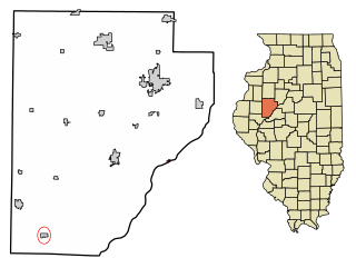
Liverpool is a village in Fulton County, Illinois, United States. The population was 94 at the 2010 census.

<span class="mw-page-title-main">Channel Lake, Illinois</span> Census-designated place in Illinois, United States

Channel Lake is an unincorporated community and census-designated place (CDP) in Antioch Township, Lake County, Illinois, United States. Per the 2020 census, the population was 1,581.

Fox Lake Hills is an unincorporated community and census-designated place (CDP) in Lake Villa Township, Lake County, Illinois, United States. Per the 2020 census, the population was 2,684.

Venetian Village is a census-designated place (CDP) in Lake County, Illinois, United States. Per the 2020 census, the population was 2,761.

West Union is an unincorporated census-designated place located in York Township in the southeast corner of Clark County, Illinois, on Illinois Route 1. Its postal zip code is 62477. As of the 2020 census, its population was 271.

<span class="mw-page-title-main">Houston Township, Adams County, Illinois</span> Township in Illinois, United States

Houston Township is one of twenty-two townships in Adams County, Illinois, United States. As of the 2020 census, its population was 186 and it contained 97 housing units.

<span class="mw-page-title-main">Garden Prairie, Illinois</span> CDP in Illinois, United States

Garden Prairie is an unincorporated former village and census-designated place located in Boone County, Illinois, United States. It is part of the Rockford, Illinois Metropolitan Statistical Area.

Penfield is an unincorporated census-designated place in Compromise Township, Champaign County, Illinois, United States. Its population was 151 at the 2020 census.

Langleyville is an unincorporated census-designated place in Christian County, Illinois, United States. As of the 2020 census, it had a population of 391.

La Clede is an unincorporated community in La Clede Township, Fayette County, Illinois, United States.

Dayton is a census-designated place in LaSalle County, Illinois, United States. The community was built along the Fox River a few miles north of Ottawa. As of the 2020 Census, its population was 528.

Annapolis is an unincorporated census-designated place (CDP) in Crawford County, Illinois, United States. Annapolis is 10 miles (16 km) north-northwest of Robinson. Annapolis has a post office with ZIP code 62413. Its population was 106 as of 2020.

West York is an unincorporated census-designated place in Crawford County, Illinois, United States. West York is 4.5 miles (7.2 km) north of Hutsonville. West York has a post office with ZIP code 62478. As of the 2020 census, the population was 74.

References

  1. "2020 U.S. Gazetteer Files". United States Census Bureau. Retrieved March 15, 2022.
  2. U.S. Geological Survey Geographic Names Information System: Unity, Illinois
  3. 1 2 "Explore Census Data". data.census.gov. Retrieved June 28, 2022.
  4. Bureau, US Census. "Gazetteer Files". Census.gov. Retrieved June 29, 2022.
  5. "Census of Population and Housing". Census.gov. Retrieved June 4, 2016.
  6. "P2 Hispanic or Latino, and Not Hispanic or Latino by Race – 2020: DEC Redistricting Data (PL 94-171) – Unity CDP, Illinois". United States Census Bureau .
  7. "2020 CENSUS - SCHOOL DISTRICT REFERENCE MAP: Alexander County, IL" (PDF). U.S. Census Bureau . Retrieved February 23, 2022.