Monroe County is a county located on the eastern border of the U.S. state of Ohio, across the Ohio River from West Virginia. As of the 2020 census, the population was 13,385, making it the second-least populous county in Ohio. Its county seat is Woodsfield. The county was created in 1813 and later organized in 1815.

Loves Park is a city in Boone and Winnebago counties in the U.S. state of Illinois. Most of the city is in Winnebago County, with a tiny sliver in the east located in Boone County. The population was 23,397 at the 2020 census.
Huntley is a village in McHenry and Kane counties, Illinois, United States. As of the 2021 census it had a population of 28,008. It is a part of the Chicago metropolitan area.

Yates City is a village in Knox County, Illinois, United States. The population was 642 at the 2020 census. It is part of the Galesburg Micropolitan Statistical Area.
Tonica is a village in LaSalle County, Illinois, United States. The population was 749 at the 2020 census, down from 768 at the 2010 census. It is part of the Ottawa Micropolitan Statistical Area.
Troy Grove is a village in LaSalle County, Illinois, United States. The population was 225 at the 2020 census, down from 250 at the 2010 census. It is part of the Ottawa, IL Micropolitan Statistical Area.

Girard is a city in Macoupin County, Illinois, United States. The population was 1,785 at the 2020 census, down from 2,103 in 2010.

Palmyra is a village in Macoupin County, Illinois, United States. The population was 605 at the 2020 census, down from 698 in 2010.
Marengo is a city in McHenry County, Illinois, United States on the Kishwaukee River. It lies approximately 60 miles west northwest of Chicago and approximately 30 miles east of Rockford. Per the 2020 census, the population was 7,568.

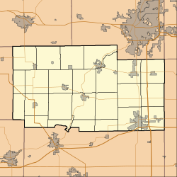
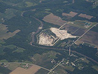
Davis Junction is a village in Ogle County, Illinois, United States. The population was 2,512 at the 2020 census. Named for Jeremiah Davis, it is located where the Illinois Railway Rockford Line and the Canadian Pacific Railway Chicago Subdivision intersect along Illinois Route 72. It is the site of the Orchard Hills Landfill - one of the largest in the United States.

Stillman Valley is a village in Marion Township, Ogle County, Illinois, United States. It lies east of Byron, south of Rockford and west of Davis Junction. The population was 1,120 at the 2010 census, up from 1,048 in 2000. The village is located on the Iowa, Chicago and Eastern Railroad, on the old Chicago Great Western Railway before it merged and was pulled up. Also, Illinois Route 72 runs through the village. It is near the site of the first battle of the Black Hawk War of 1832. The war memorial for the Battle of Stillman's Run is located in this village.

Pleasant Plains is a village in Sangamon County, Illinois, United States. The population was 802 at the 2010 census. It is part of the Springfield, Illinois Metropolitan Statistical Area. The village was incorporated April 8, 1876

Indianola is a village in Carroll Township, Vermilion County, Illinois, United States. It is part of the Danville, Illinois Metropolitan Statistical Area. The population was 207 at the 2000 census.

Tampico is a village located in Tampico Township, Whiteside County, Illinois, United States next to Rock Falls and Sterling, Illinois. As of the 2010 census the village had a total population of 790, up from 772 at the 2000 census. It is known as the birthplace of Ronald Reagan, the 40th President of the United States.
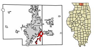
Cherry Valley is a village of 8.72 square miles (22.6 km2) that lies primarily in Winnebago County. Approximately ten percent of the village is within Boone County. The village is within the Rockford, Illinois Metropolitan Statistical Area, and borders the southeast side of Rockford. It is also within the Kishwaukee River valley. The population is 2905 at the 2020 census, down from 3,162 as of the 2010 census.
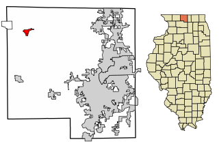
Durand is a village in Winnebago County, Illinois, United States. It is part of the Rockford, Illinois Metropolitan Statistical Area The population was 1,443 at the 2010 census, up from 1,081 in 2000.

Machesney Park is a village located in Winnebago County, Illinois, United States. The population was 23,499 at the 2010 census, up from 20,759 in 2000. Machesney Park is part of the Rockford, Illinois Metropolitan Statistical Area.
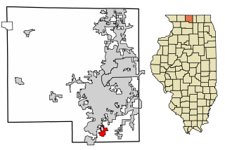
New Milford is a village in Winnebago County, Illinois, United States on the south bank of the Kishwaukee River overlooking the south side of Rockford. It is part of the Rockford, Illinois Metropolitan Statistical Area. The population was 697 at the 2010 census, up from 541 in 2000.

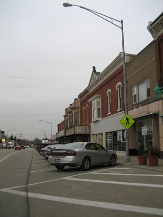
Roscoe is a village in Winnebago County, Illinois, along the Rock River. It is in a suburban area of the Rockford, Illinois Metropolitan Statistical Area. As of the 2010 census, the village population was 10,785, up from 6,244 at the 2000 census. The area has been undergoing a period of rapid growth. There have been numerous border disputes with its neighbor to the west, Rockton, Illinois, and development and annexations continue by both villages. Recent growth has included the Promontory Ridge and Hidden Creek custom home subdivisions east of the Illinois Tollway, I-39/I-90.

Rockford is a city in Wright and Hennepin counties in the U.S. state of Minnesota. The population was 4,316 at the 2010 census. While Rockford is mainly located within Wright County, a small part of the city extends into Hennepin County. It is part of the Minneapolis–Saint Paul metropolitan statistical area. Minnesota State Highway 55 serves as a main route in the city.