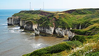
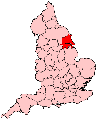
The East Riding of Yorkshire, often abbreviated to the East Riding or East Yorkshire, is a ceremonial county in the Yorkshire and the Humber region of England. It borders North Yorkshire to the north and west, South Yorkshire to the south-west, and Lincolnshire to the south across the Humber Estuary. The city of Kingston upon Hull is the largest settlement.

North Lincolnshire is a unitary authority area with borough status in Lincolnshire, England. At the 2011 Census, it had a population of 167,446. The administrative centre and largest settlement is Scunthorpe, and the borough also includes the towns of Brigg, Broughton, Haxey, Crowle, Epworth, Bottesford, Winterton, Kirton in Lindsey and Barton-upon-Humber. North Lincolnshire is part of the Yorkshire and the Humber region.

Goole is a port town and civil parish on the River Ouse in the East Riding of Yorkshire, England. The town's historic county is the West Riding of Yorkshire.
Humberside was a non-metropolitan and ceremonial county in Northern England from 1 April 1974 until 1 April 1996. It was composed of land from either side of the Humber, created from portions of the East Riding of Yorkshire, West Riding of Yorkshire, and the northern part of Lindsey, Lincolnshire. The county council's headquarters was County Hall at Beverley, inherited from East Riding County Council. Its largest settlement and only city was Kingston upon Hull. Other notable towns included Goole, Beverley, Scunthorpe, Grimsby, Cleethorpes and Bridlington. The county stretched from Wold Newton at its northern tip to a different Wold Newton at its southernmost point.

The counties of England are divisions of England. Counties have been used as administrative areas in England since Anglo-Saxon times. There are two main legal definitions of the counties in modern usage: the 84 counties for the purposes of local government, and the 48 counties for the purposes of lieutenancy, also termed the ceremonial counties.

The postal counties of the United Kingdom, now known as former postal counties, were postal subdivisions in routine use by the Royal Mail until 1996. The purpose of the postal county – as opposed to any other kind of county – was to aid the sorting of mail by differentiating between like-sounding post towns. Since 1996 this has been done by using the outward code of the postcode instead. For operational reasons the former postal counties, although broadly based on the counties of the United Kingdom, did not match up with their boundaries: in some cases there were significant differences. The boundaries changed over time as post towns were created or amended.

Boothferry is a village in the East Riding of Yorkshire in England. It is situated on the north bank of the River Ouse where the A614 road crosses the river. It is about 2 miles (3 km) north-west of Goole.

Haltemprice and Howden is a constituency in the East Riding of Yorkshire represented in the House of Commons of the UK Parliament since 1997 by David Davis, a Conservative who was also Secretary of State for Exiting the European Union until his resignation from that role on 8 July 2018.

Brigg and Goole is a constituency in Yorkshire and Lincolnshire represented in the House of Commons of the UK Parliament since 2010 by Andrew Percy, a Conservative.

Brough is a town in the East Riding of Yorkshire, England. It is part of the civil parish of Elloughton-cum-Brough with the neighbouring village of Elloughton. Brough is situated on the northern bank of the Humber Estuary, approximately 12 miles (19 km) west of Hull city centre. Brough has a long association with BAE Systems.

The Borough of Boothferry was, from 1 April 1974 to 1 April 1996, a local government district with borough status within the non-metropolitan county of Humberside. The district is now split between the East Riding of Yorkshire and North Lincolnshire.

South Humberside is a former postal county of England. It was introduced by the Royal Mail on 1 July 1974, when some addresses were altered in response to the changes in administration brought about under the Local Government Act 1972.
The DN postcode area, also known as the Doncaster postcode area, is a group of 32 postcode districts in eastern England, within 13 post towns. These cover eastern South Yorkshire, north Lincolnshire, parts of north Nottinghamshire and the south-west of the East Riding of Yorkshire, and a small part of southern North Yorkshire.
The YO postcode area, also known as the York postcode area, is a group of 29 postcode districts in Yorkshire, England, within ten post towns. These cover most of Central and Eastern North Yorkshire and the northern part of the East Riding of Yorkshire. The rest of North Yorkshire is split between the TS, DL, LA, BD, HG, DN and WF postcode areas.
The HU postcode area, also known as the Hull postcode area, is a group of twenty postcode districts in England, within eight post towns. These cover the south of the East Riding of Yorkshire, including Hull, Beverley, Cottingham, Hessle, Hornsea, Withernsea, Brough and North Ferriby.
The history of local government in Yorkshire is unique and complex. Yorkshire is the largest historic English county and consists of a diverse mix of urban and rural development with a heritage in agriculture, manufacturing, and mining. After a long period with little change, it has been subject to a number of reforms of local government structures in modern times, some of which were controversial. The most significant of these were the Local Government Act 1972, the 1990s UK local government reform, and the Localism Act 2011. The historic area currently corresponds to several counties and districts and is mostly contained within the Yorkshire and the Humber region.
The East Riding of Yorkshire is a local government district with unitary authority status, and is a ceremonial county of England. It is named after the historic East Riding of Yorkshire which was one of three ridings alongside the North Riding and West Riding, which were constituent parts a Yorkshire ceremonial and administrative county until 1974. From 1974 to 1996 the area of the modern East Riding of Yorkshire constituted the northern part of Humberside.

East Riding of Yorkshire Council is the local authority for the East Riding of Yorkshire, a local government district within the larger ceremonial county of the same name. It is a unitary authority, being a district council which also performs the functions of a county council. The council has been under no overall control since 2023, being led by a Conservative minority administration. It is based at County Hall in Beverley.
