Northeast Siberian taiga

Last updated
Northeast Siberian taiga
Larix gmelinii0.jpg
Dahurian larch trees, Kolyma region, arctic northeast Siberia
Ecoregion PA0605.png
Ecoregion territory (in purple)
Ecology
Realm Palearctic
Biome Boreal forests/taiga
Geography
Area1,529.373 km2 (590.494 sq mi)
Country Russia
Rivers Lena River, Kolyma River
Climate typeDfd

The Northeast Siberian taiga ecoregion (WWF ID: PA0605) is an area of "sparse taiga forest" between the Lena River and the Kolyma River in northeastern Siberia, Russia. The ecoregion's internal borders form a patchwork of territory constituting the southern part of the East Siberian Lowland, as well as lowlands around the East Siberian Mountains, including the ridges and peaks of the Verkhoyansk Range and the Chersky Range. On the southern border of the ecoregion is the north coast of the Sea of Okhotsk, giving the region maritime boreal forests as well as the continental forests situated inland. The ecoregion is one of the largest tracts of virgin boreal forest in the world, due to the very sparse population and difficult access. It is mostly in the Sakha Republic (Yakutsk region). [1] [2] [3] [4] [5]

Contents

Location and description

The ecoregion covers an area about 1,800 km west–east by 1,000 km north–south. The western border is the Lena River; beyond that is the East Siberian taiga ecoregion. The eastern edge is the Kolyma River, beyond which farther east is the Bering tundra ecoregion. To the north is a strip Arctic coastal tundra about 100 km wide, the Northeast Siberian coastal tundra ecoregion. The Okhotsk Sea to the south completes the outline of the ecoregion, but internally the Verhkoyansk and Chersky mountains (which are in the "Cherskii-Kolyma mountain tundra" ecoregion) confines the ecoregion into valleys and lowlands. [6] The region is in the Palearctic realm (Euro-Siberian region). It covers 1,670,283 km2 (644,900 sq mi).

The Verkhovyansk Range is an "L-shaped" range that runs down the east side of the Lena before turning west–east across the south of the ecoregion. They Chersky Range runs northwest-to-southeast through the middles of the region. Their upper slopes and peaks are too cold and dry to support the forests and flora of the lowlands in the Northeast Siberian taiga ecoregion. To the east and north of the mountains is the Kolyma River basin. In addition to the Kolyma River, the ecoregion contains the Indigirka River and the Yana River. [7]

Climate

The region has an extreme subarctic climate (Köppen climate classification Dfd), with long, extremely cold winters and short warm summers. [8] Regions with a Dfd climate have 1-3 months with temperatures averaging above 10 °C (50 °F) and at least one month with mean temperatures below −38 °C (−36 °F) , this region has some of the coldest winters in the Northern Hemisphere with the lowest temperature recorded being −68 °C (−90 °F).

Verkhoyansk, Sakha Republic, Russia
Climate chart (explanation)
J
F
M
A
M
J
J
A
S
O
N
D
 
 
6
 
 
−43
−49
 
 
6
 
 
−37
−46
 
 
5
 
 
−20
−39
 
 
6
 
 
−3
−22
 
 
12
 
 
10
−3
 
 
23
 
 
20
6
 
 
33
 
 
23
9
 
 
32
 
 
18
4
 
 
14
 
 
9
−3
 
 
13
 
 
−9
−19
 
 
10
 
 
−32
−40
 
 
8
 
 
−40
−47
Average max. and min. temperatures in °C
Precipitation totals in mm
Source: Pogoda.ru.net
Imperial conversion
JFMAMJJASOND
 
 
0.2
 
 
−45
−56
 
 
0.2
 
 
−34
−51
 
 
0.2
 
 
−4
−37
 
 
0.2
 
 
26
−8
 
 
0.5
 
 
50
27
 
 
0.9
 
 
68
43
 
 
1.3
 
 
74
48
 
 
1.3
 
 
65
40
 
 
0.6
 
 
47
27
 
 
0.5
 
 
16
−3
 
 
0.4
 
 
−26
−40
 
 
0.3
 
 
−40
−52
Average max. and min. temperatures in °F
Precipitation totals in inches

Precipitation is relatively low, ranging from 150–200 mm/year in central Yakutia, to 400–500 mm/year in the mountains.

Flora

The dominant trees are Larix cajanderi (larch) and Betula pendula (silver birch), with a ground cover of Pinus pumila (Siberian dwarf pine) and lichen. Further development of the forest is limited by the continuous permafrost of the area, and by the harsh cold winters and relatively low precipitation. [6] The region is a large sink for atmospheric carbon dioxide. [9]

In the lowland floodplains there are steppe floral communities that feature fescue ( Festuca ), wheatgrass, alpine oatgrass ( Helictotrichon ), cinquefoils ( Potentilla tollii), Orostachys spinosa, Carex pediformis, and others. [7] The ecoregion is one of the floral regions of the Circumboreal Region.

Fauna

Migrant waterfowl are common in the northern areas near the tundra; species include Melanitta nigra (Common scoter), Anser fabalis (Bean goose), and Anas formosa (Baikal teal). Off the rocky coast of the Sea of Okhotsk are important breading areas for seabirds. Over one million individuals from 15 species are seen in the area, and is one of the only breeding grounds for the Little curlew and the critically endangered Siberian crane.

The Siberian taiga also is home to galliforms, like the willow ptarmigan (Lagopus lagopus) and rock ptarmigan (Lagopus muta) in areas of open tundra. Populations of black-billed capercaillies (Tetrao urogalloides) and hazel grouse (Tetrastes bonasia) tend to inhabit forested habitat.

Common mammals are elk (Alces alces), Siberian chipmunk (Eutamias sibiricus), lynx (Felis lynx), Siberian weasel (Mustela sibirica), red fox (Vulpes vulpes) and brown bear (Ursus arctos).

Protections

Notable protected areas of the Russian Federation in the West Siberian taiga include:

Threats

The region is relatively untouched by human activities; the region is one of the largest virgin forests in the world. There is some mining activity, and logging. As usual with boreal forests, wild fires are a threat in the summer.

Urban areas and settlements

The area is sparsely populated; the only city is Magadan on the Okhotsk Sea, and scattered mining and logging villages. [6] [7]

See also

Related Research Articles

<span class="mw-page-title-main">East Siberian taiga</span> Biogeographic region in eastern Russia

The East Siberian taiga ecoregion, in the Taiga and boreal forests biome, is a very large biogeographic region in eastern Russia.

<span class="mw-page-title-main">Pechora-Ilych Nature Reserve</span> Strict nature reserve in the Komi Republic, Russia

Pechora-Ilych Nature Reserve is a Russian 'zapovednik' in the Komi Republic, Russia. It currently occupies 7,213 square kilometers and forms the core of the World Heritage Site Virgin Komi Forests.

<span class="mw-page-title-main">Bureya Nature Reserve</span> Nature reserve in Khabarovsk Krai, Russia

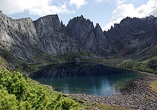
Bureya Nature Reserve is a protected area (Zapovednik) about 200 km northwest of the city of Khabarovsk, in the Verkhnebureinsky District of Khabarovsk Krai, in the Russian Far East. The territory is one of mountain tundra, rivers and lakes, and taiga forests. It includes the headwaters of the left and right tributaries of the Bureya River, part of the lower Amur River basin. The reserve was created in 1987, and covers an area of 358,444 ha (1,383.96 sq mi).

<span class="mw-page-title-main">Olyokma Nature Reserve</span> Nature reserve in the Sakha Republic, Russia

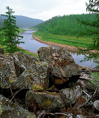
Olyokma Nature Reserve is a Russian 'zapovednik' located south of the middle reaches of the Lena River on the right bank of its second largest tributary - the Olyokma River at the junction of the Aldan Highlands and the Olyokma-Chara Plateau in Olyokminsky District of the Sakha Republic (Yakutia). The area is remote and relatively undisturbed, being 80 km from a town.

<span class="mw-page-title-main">Dzhugdzur Nature Reserve</span> Nature reserve in Khabarovsk Krai, Russia

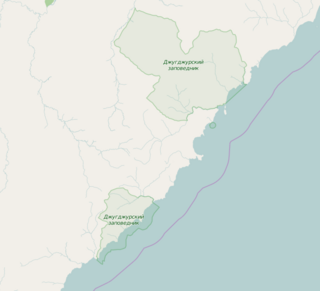
Dzhugdzursky Nature Reserve is a Russian 'zapovednik' on the coast of the Sea of Okhotsk, on the territory of Ayano-Maisky region of the Khabarovsk Territory in the Russian Far East. With over 8,000 km2 of land area and over 500 km2 of marine area, it is the largest of the six nature reserves in Khabarovsk Krai. It supports spawning streams into the Okhotsk Sea for chum, pink salmon and coho salmon.

<span class="mw-page-title-main">Transbaikal conifer forests</span> Ecoregion in southern Siberia and Mongolia

The Transbaikal conifer forests ecoregion covers a 1,000 km by 1,000 km region of mountainous southern taiga stretching east and south from the shores of Lake Baikal in the Southern Siberia region of Russia, and including part of northern Mongolia. Historically, the area has been called "Dauria", or Transbaikal. It is in the Palearctic realm, and mostly in the boreal forests/taiga biome with a subarctic, humid climate. It covers 200,465 km2 (77,400 sq mi).

<span class="mw-page-title-main">West Siberian taiga</span> Ecoregion which covers the West Siberian Plain in Russia

The West Siberian taiga ecoregion covers the West Siberian Plain in Russia, from the Ural mountains in the west to the Yenisei River in the east, and roughly from 56° N to 66° N latitude. It is a vast, flat lowland region of boreal forests (taiga), and wetlands, covering an area about 1,800 km west–east, by 1,000 km north–south.

<span class="mw-page-title-main">Okhotsk–Manchurian taiga</span> Ecoregion in the Russian Far East

The Okhotsk-Manchurian taiga ecoregion is an area of coniferous forests in the Russian Far East, covering the Amur River delta, the west coast of the Okhotsk Sea, and the rugged extension of the northern Sikhote-Alin Mountains that run southwest-to-northeast through the Primorsky and Khabarovsk regions. It is the southernmost taiga forest in Eurasia. The ecoregion is distinguished from surrounding ecoregions by the slightly warmer climate due to the maritime influence and the shield of the mountains to the west, and by the mixing of flora and fauna species from Okhotsk-Kamchatka communities to the north and Manchurian species from the south. The forest at lower altitudes is "light taiga", and "dark taiga" at higher altitudes.

<span class="mw-page-title-main">Kamchatka Taiga</span> Ecoregion in the middle of the Kamchatka Peninsula

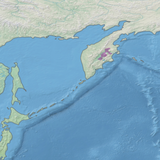
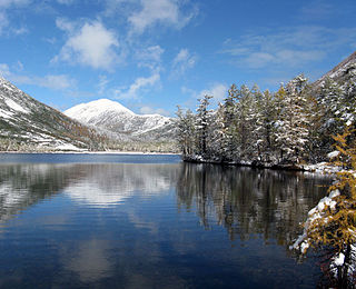
The Kamchatka Taiga ecoregion is a "conifer island" in the middle of the Kamchatka Peninsula, along the Kamchatka River. It is the easternmost example of Siberian taiga. The region has unusual ecological conditions, a "snow forest" that combines low temperatures, high humidity and boreal forest with heavy snowfall. The local ecology is also affected by volcanic activity. The region is about 300 km long (north–south), and averages about 100 km west–east. It is in the Palearctic realm, and mostly in the Boreal forests/taiga ecoregion with a humid continental climate, cool summer climate. It covers 147,064 km2 (56,782 sq mi).

<span class="mw-page-title-main">Cherskii–Kolyma mountain tundra</span>

The Cherskii–Kolyma mountain tundra ecoregion is an ecoregion that covers the higher elevations of the Chersky Range and the Kolyma Mountains, the only large mountain range in northern Russia. It is in the Palearctic realm, and tundra biome. It has an area of 556,589 square kilometres (214,900 sq mi).

<span class="mw-page-title-main">Northeast Siberian coastal tundra</span>

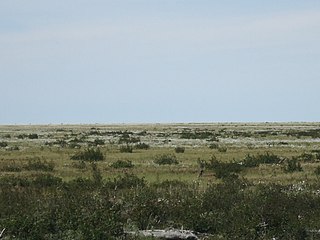
The Northeast Siberian coastal tundra ecoregion is an ecoregion that covers the coastal plain of the central north region of Siberia in Russia. This coastal region borders the Laptev Sea and the East Siberian Sea, both marginal seas of the Arctic Ocean, from the Lena River delta in the west to the Kolyma River delta in the east. There are several large river deltas in the area that support breeding grounds for 60 to 80 species of migratory birds. The region is in the Palearctic realm, and the tundra biome. It has an area of 846,149 square kilometres (326,700 sq mi).

<span class="mw-page-title-main">Transbaikal Bald Mountain tundra</span>

The Transbaikal Bald Mountain tundra ecoregion covers the high-altitude peak zones above the treeline in a series of mountain ranges that stretch from the northern reaches of Lake Baikal to the western coastal ranges of the Okhotsk Sea. Floral communities are those of mountain tundra, with bare rock or permafrost under layers of moss and lichen. Because the ecoregion is aligned along a common latitude, it acts as a route for the transmission of species across Siberia. The ecoregion is in the Palearctic realm and the tundra biome. It has an area of 217,559 square kilometres (84,000 sq mi).

<span class="mw-page-title-main">East Siberian Lowland</span> Plain in Siberia, Russia

The East Siberian Lowland, also known as Yana-Kolyma Lowland, is a vast plain in North-eastern Siberia, Russia. The territory of the lowland is one of the Great Russian Regions. Administratively, it is a part of the Sakha Republic (Yakutia).

<span class="mw-page-title-main">East Siberian Mountains</span> Mountain range in Russia

The East Siberian Mountains or East Siberian Highlands are one of the largest mountain systems of the Russian Federation. They are located between the Central Yakutian Lowland and the Bering Strait in Northeast Siberia. The area of the East Siberian Mountains has a very low population density. The territory of the mountain system is one of the Great Russian Regions.

<span class="mw-page-title-main">Northwest Territories taiga</span> Taiga ecoregion located in the Northwest Territories and Yukon provinces of Canada

The Northwest Territories taiga ecoregion (WWF:NA0614) is located in the Northwest Territories and Yukon provinces of Canada. It covers forest and tundra along the Mackenzie River Valley and the surrounding highlands in the southern portion of the valley.

<span class="mw-page-title-main">Interior Yukon–Alaska alpine tundra</span>

The Interior Yukon-Alaska alpine tundra ecoregion covers alpine, sub-alpine, and boreal forest areas along the cordillera of Interior Alaska and south-central Yukon Territory. Geologically, they are the disjunct uplands of the Yukon-Tanana Terrane plus a southern extension of the Brooks Range. The cover is extensive 'dark taiga' of closed spruce forest, open forest of other species, and alpine vegetation at higher altitudes. The region is mostly wilderness and relatively untouched by human development.

<span class="mw-page-title-main">Ogilvie–MacKenzie alpine tundra</span> Tundra ecoregion of Canada and the United States

The Ogilvie–MacKenzie alpine tundra ecoregion covers the mountainous middle of the Yukon Territory in Canada, with extensions into the Northwest Territories. The vegetation is alpine and subalpine open forest of stunted spruce, fir and pine. The area is rugged but sections appear to have been unglaciated in the late Pleistocene and there are therefore relic species in the region. The area is remote and supports large, sustainable predator-prey systems.

Tokinsko-Stanovoy National Park is located at the mountainous headwaters of the Zeya River, in the Stanovoy Highlands of the Russian Far East. It was created in 2019 to protect important natural features - particularly the Siberian snow sheep, and also the cultural heritage of the reindeer-herding indigenous Evenki people. The park is located in the Zeysky District of Amur Oblast, at the meeting point of the borders of Amur Oblast, the Sakha Republic, and Khabarovsk Krai.

<span class="mw-page-title-main">Zigalga National Park</span>

Zigalga National Park is located on the high Zigalga Ridge of the Southern Ural Mountains in Russia, on the transition between Europe and Siberia. Much of the territory is untouched by human activity and so supports Ice Age relict floral communities through all altitude zones - pine and birch forest, dark coniferous taiga, alpine meadows and mountain tundra. The park was officially created in 2019. The park is located in the Katav-Ivanovsky District of Chelyabinsk Oblast.

References

  1. "Map of Ecoregions 2017". Resolve, using WWF data. Retrieved September 14, 2019.
  2. Kottek, M.; Grieser, J.; Beck, C.; Rudolf, B.; Rubel, F. (2006). "World Map of Koppen-Geiger Climate Classification Updated" (PDF). Gebrüder Borntraeger 2006. Retrieved September 14, 2019.
  3. "Dataset - Koppen climate classifications". World Bank. Retrieved September 14, 2019.
  4. "Northeast Siberian taiga". Encyclopedia of Earth. Retrieved October 20, 2020.
  5. "Northeast Siberian taiga". Digital Observatory for Protected Areas. Retrieved October 20, 2020.
  6. 1 2 3 "Northeast Siberian Taiga". World Ecoregions. GlobalSpecies.org. Retrieved 18 June 2016.
  7. 1 2 3 "Northeast Siberian Taiga". Terrestrial Ecoregions. World Wildlife Federation. Retrieved 17 June 2016.
  8. "Climate - Northeast Siberian taiga". Global Species - Ecoregions. Global Species. Retrieved 10 July 2016.
  9. "Palearctic Boreal Ecoregions". Global Forest Atlas. Yale school of forestry and environmental studies. Retrieved 10 July 2016.