Northern Thailand

Last updated

Northern Region
ภาคเหนือ
Intanon 03.jpg
d`yphaahmpk.jpg
Phra That Doi Suthep 01.jpg
Friendship Bridge - panoramio (6).jpg
phuuchiifaa 501.jpg
Thailand North six regions.png
Northern Region in Thailand
Largest city Chiang Mai
Provinces
Area
[1]
  Total96,077 km2 (37,096 sq mi)
Population
 (2019) [2]
  Total6,350,499
  Density66/km2 (170/sq mi)
Demonym Khon Muang
GDP
[3]
  TotalUS$41.9 billion (2019)
Time zone UTC+07:00 (ICT)
Language ThaiNorthern ThaiLolo-BurmeseKarenic • • MienicPalaungicSouthwestern Mandarin etc.


Northern Thailand, or more specifically Lanna , is geographically characterised by several mountain ranges, which continue from the Shan Hills in bordering Myanmar to Laos, and the river valleys that cut through them. Like most of Thailand, it has a tropical savanna climate, but its relatively high elevation and latitude contribute to more pronounced seasonal temperature variation, with cooler winters than the other regions.

Contents

Historically, northern Thailand has been linked to the Hariphunchai Kingdom, which emerged as a powerful state in the region in the 7th century. This kingdom was related to the Dvaravati that existed from the 6th to 11th centuries. The Hariphunchai culture later influenced the development of the Lanna Kingdom, which emerged in the 13th century and lasted until the 18th century. [4] [5]

Geography

North Thailand is bound by the Salween River in the west and the Mekong in the east. The basins of rivers Ping, Wang, Yom, and Nan, all tributaries of the Chao Phraya River, in the central part run from north to south and are mostly very wide. The basins cut across the mountains of two great ranges, the Thanon Range in the western part and the Phi Pan Nam in the eastern. Their elevations are generally moderate, a little above 2,000 metres (6,562 ft) for the highest summits. Although formerly forested, many of these mountains are now denuded. [6]

Parallel mountain ranges extend from the Daen Lao Range (ทิวเขาแดนลาว), in the southern region of the Shan Hills, in a north–south direction, the Dawna Range (ทิวเขาดอยมอนกุจู) forming the western border of Thailand between Mae Hong Son and the Salween River. [7] To the east the Thanon Thong Chai Range (เทือกเขาถนนธงชัย), the Khun Tan Range (ทิวเขาขุนตาน), the Phi Pan Nam Range (ทิวเขาผีปันน้ำ), as well as the western part of the Luang Prabang Range (ทิวเขาหลวงพระบาง), form the natural region of the Thai highlands together with the former. [8]

The high mountains are incised by steep river valleys and upland areas that border the central plain. A series of rivers, including the Nan, Ping, Wang, Yom, and Nan, flow southwards through mountain valleys and join to form the Chao Phraya in Nakhon Sawan Province in the central region. Sirikit Dam is on the Nan River in Uttaradit Province. The northeastern part is drained by rivers flowing into the Mekong basin, like the Kok and Ing.

The four-region system includes the northern parts of the central plain as well as some mountainous areas bordering the western and the northeastern limits. The total forest area is 90,228 km2 (34,837 sq mi) or 52.5 percent of this four-region area. [1]

Map of Thailand highlighting the provinces of the northern region in the six-region system Topography of northern Thailand.png
Map of Thailand highlighting the provinces of the northern region in the six-region system
Northern Thailand according to the four-region grouping system Thailand North.png
Northern Thailand according to the four-region grouping system

National parks

Within the northern region there are some sixty national parks. Chiang Mai Province has nine national parks of which Doi Inthanon National Park with the country's highest mountain and Op Luang National Park have a scenic river canyon, waterfalls, and caves. Doi Khun Tan National Park, which is located midway between the two provincial capitals of province Lampang and Lamphun, is best known for Thailand's longest railroad tunnel, which is 1,352 metres (4,436 ft) long. Doi Phu Kha National Park in province Nan is northern Thailand's largest national park.

Regional classification of northern Thailand

The northern region, as defined by the National Geographical Committee in 1978, consists of nine provinces. Geographically the division, in conformance with the six-region system, includes most of the mountainous natural region of the Thai highlands.

In the four-region classification system, northern Thailand gains the eight upper-central-region provinces: Kamphaeng Phet, Nakhon Sawan, Phetchabun, Phichit, Phitsanulok, Sukhothai, Uthai Thani and Tak, bringing the total to 17 provinces.

In 2019 it is common to subdivide the northern region into: nine provinces of the upper northern region and eight provinces of the lower northern region. All websites of these eight provinces state: "located in the lower northern region".

Upper and Lower Northern provinces Thailand Upper Lower North.png
Upper and Lower Northern provinces
FlagSealProvinceCapital DOPA PopulationArea (km2)Density ISO
Chiangmai Provincial Flag.png Seal Chiang Mai.png 1 Chiang Mai Chiang Mai 141,779,25422,13579TH-50
Lamphun provincial flag.png Seal Lamphun.png 2 Lamphun Lamphun 54405,0754,47892TH-51
Flag of Lampang Province.png Seal Lampang.png 3 Lampang Lampang 53738,31612,48859TH-52
Uttaradit provincial flag.png Seal Uttaradit.png 4 Uttaradit Uttaradit 75453,1037,90658TH-53
Phrae flag.svg Seal of Phrae Province (colour version, as the provincial administration used).svg 5 Phrae Phrae 41441,7266,48368TH-54
thngpracchamcchanghwadnaan.svg Seal of Nan province.svg 6 Nan Nan 26478,22712,13040TH-55
Phayao flag.svg Seal Phayao.png 7 Phayao Phayao 34472,3566,18976TH-56
Flag of Chiang Rai.gif Seal Chiang Rai.svg 8 Chiang Rai Chiang Rai 131,298,30411,503113TH-57
Flag Mae Hong Son Province.png Seal Mae Hong Son.svg 9 Mae Hong Son Mae Hong Son 45284,13812,76523TH-58
Flag Nakhon Sawan Province.png Seal Nakhon Sawan.png 10 Nakhon Sawan Nakhon Sawan 231,059,8879,526111TH-60
Flag of Uthai Thani Province.jpg Seal Uthaithani.png 11 Uthai Thani Uthai Thani 76328,6186,64750TH-61
Kamphaeng Phet Flag.png Seal Kamphaeng Phet.png 12 Kamphaeng Phet Kamphaeng Phet 5725,8678,512386TH-62
Flag of Tak Province.png Seal Tak.png 13 Tak Tak 17665,62017,30339TH-63
Flag of Sukhothai Province.svg Seal of Sukhothai Province (color version).svg 14 Sukhothai Sukhothai 66595,0726,67189TH-64
Pitsanulok flag.svg Seal of Phitsanulok Province.svg 15 Phitsanulok Phitsanulok 38865,24710,58982TH-65
Flag of Phichit Province.png Seal Phichit.png 16 Phichit Phichit 37536,3114,319124TH-66
Phetchabun provincial flag.png Seal Phetchabun.png 17 Phetchabun Phetchabun 40992,45112,34080TH-67

Economy

For FY 2018, Northern Thailand Region had a combined economic output of 1,266 trillion baht (US$40.8 billion), or 7.7 percent of Thailand's GDP. Lamphun province had an economic output of 84.395 billion baht (US$2.7 billion). This equates to a GPP per capita of 211,489 baht (US$6,822), half more than for Chiang Mai province, next in the ranking and double than for Lampang province, which is third in the ranking. [9]

Gross Provincial Product (GPP)
RankProvinceGPP
(million baht)
Population
(x 1000)
GPP per capita (baht)
1Lamphun84,395399211,489
2Chiang Mai247,8311,805137,316
3Lampang71,950714100,709
4Phayao37,29838397,306
5Chiang Rai110,8151,15695,895
6Uttaradit39,19041694,260
7Phrae30,40338878,276
8Nan33,67444575,676
9Mae Hong Son13,72823558,370
 Upper provinces669,2845,941112,655

Kamphaeng Phet province had an economic output of 117.705 billion baht (US$3.8 billion). This amounts to a GPP per capita of 150,783 baht (US$4,864), half more than for Tak province, which is fifth in the ranking.

Gross Provincial Product (GPP)
RankProvinceGPP
(million baht)
Population
(x 1000)
GPP per capita (baht)
1Kamphaeng Phet117,705781150,783
2Nakhon Sawan116,147938123,865
3Phitsanulok100,286896111,872
4Uthai Thani29,879281106,369
5Tak52,72053299,026
6Phichit48,34751893,265
7Phetchabun81,90992188,971
8Sukhothai50,38461382,147
 Lower provinces597,3775,480109,010

Languages

Central Thai is the sole official language in Thailand. However, in the six-region classification system, it is the second largest native language in Northern Thailand, amounting to roughly two hundred thousand people, found in the lower part of Uttaradit Province. Central Thai spoken in southern regions of Northern Thailand in the four-region classification system comprise a group of dialects classified as Ne (Thai : เหน่อ). Because there are no significant Thai Chinese communities in Northern Thailand, the Krung Thep accent (prestige dialect) is not commonly found in Northern Thailand.[ citation needed ]

The main language is Northern Thai , which is a southwestern Tai language spoken in the 9 changwat of Northern Thailand. It is spoken by roughly six million people. There are also various hill tribe languages such as Lolo-Burmese, Karenic, Mienic, Mienic, Palaungic, Southwestern Mandarin.

Notes

See also

Related Research Articles

<span class="mw-page-title-main">Surat Thani province</span> Largest province of Thailand

Surat Thani, often shortened to Surat, is the largest of the southern provinces (changwat) of Thailand. It lies on the western shore of the Gulf of Thailand. Surat Thani means 'city of good people', a title given to the city by King Vajiravudh ; Surat Thani is therefore the sole province in Southern Thailand for which the native name is in the Central Thai language.

<span class="mw-page-title-main">Central Thailand</span> Region in Thailand

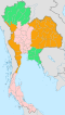
Central Thailand is one of the regions of Thailand, covering the broad alluvial plain of the Chao Phraya River. It is separated from northeast Thailand (Isan) by the Phetchabun mountain range. The Tenasserim Hills separate it from Myanmar to the west. In the north it is bounded by the Phi Pan Nam Range, one of the hilly systems of northern Thailand. The area was the heartland of the Ayutthaya Kingdom, and is still the dominant area of Thailand, containing as it does, the world's most primate city, Bangkok.

<span class="mw-page-title-main">Chiang Mai province</span> Province of Thailand

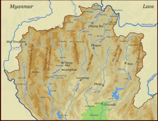
Chiang Mai is the second largest Province (changwat) of Thailand. It lies in upper northern Thailand and has a population of 1.78 million people. It is bordered by Chiang Rai to the northeast, Lampang and Lamphun to the south, Tak to the southwest, Mae Hong Son to the west, and Shan State of Burma to the north. The capital, Chiang Mai, is 685 kilometres (426 mi) north of Bangkok.

<span class="mw-page-title-main">Loei province</span> Province of Thailand

Loei, is one of the more sparsely populated provinces (changwat) of Thailand. It lies in the Isan region of upper northeastern Thailand. Neighboring provinces are Nong Khai, Udon Thani, Nong Bua Lamphu, Khon Kaen, Phetchabun, and Phitsanulok. In the north it borders Xaignabouli and Vientiane province of Laos.

<span class="mw-page-title-main">Phitsanulok province</span> Province of Thailand

Phitsanulok province, one of Thailand's seventy-six provinces, lies in lower northern Thailand. It borders Sukhothai and Uttaradit on the north, Loei and Phetchabun to the east, and Phichit and Kamphaeng Phet to the south. In the northeast it borders Laos.

<span class="mw-page-title-main">Sukhothai province</span> Province of Thailand

Sukhothai is one of Thailand's seventy-six provinces (changwat) lies in lower northern Thailand. Neighboring provinces are Phrae, Uttaradit, Phitsanulok, Kamphaeng Phet, Tak, and Lampang. Sukhothai can be translated as 'dawn of happiness'.

<span class="mw-page-title-main">Phetchabun province</span> Province of Thailand

Phetchabun is one of Thailand's seventy-six provinces (changwat) lies in lower northern Thailand. Neighbouring provinces are Loei, Khon Kaen, Chaiyaphum, Lopburi, Nakhon Sawan, Phichit and Phitsanulok.

<span class="mw-page-title-main">Nan province</span> Province of Thailand

Nan is one of Thailand's seventy-seven provinces (changwat), and lies in upper northern Thailand. Neighboring provinces are : Uttaradit, Phrae, and Phayao. To the north and east it borders Sainyabuli of Laos.

<span class="mw-page-title-main">Lamphun province</span> Province of Thailand

Lamphun is one of Thailand's seventy-six provinces (changwat), and lies in upper northern Thailand. Neighboring provinces are Chiang Mai, Lampang, and Tak.

<span class="mw-page-title-main">Phrae province</span> Province of Thailand

Phrae is one of Thailand's seventy-six Provinces (changwat) lies in upper northern Thailand. Neighboring provinces are Phayao, Nan, Uttaradit, Sukhothai, and Lampang.

<span class="mw-page-title-main">Uttaradit province</span> Province of Thailand

Uttaradit is one of Thailand's seventy-six provinces (changwat). It lies in upper northern Thailand. Neighboring provinces are Phitsanulok, Sukhothai, Phrae and Nan. To the east it borders Xaignabouli of Laos. Uttaradit is 488 km north of Bangkok, and 238 km southeast of Chiang Mai.

<span class="mw-page-title-main">Southern Thailand</span> Region in Thailand

Southern Thailand, Southern Siam or Tambralinga is a southernmost cultural region of Thailand, separated from Central Thailand region by the Kra Isthmus.

<span class="mw-page-title-main">Western Thailand</span> Region in Hua Hin

Western Thailand is a region of Thailand bordering Myanmar on the west, Southern Thailand on the south, and central Thailand on the east.

<span class="mw-page-title-main">Eastern Thailand</span> Region of Thailand

Eastern Thailand is a region of Thailand bordering Cambodia on the east, Northeastern Thailand in the north, and central Thailand on the west.

<span class="mw-page-title-main">Thai highlands</span> Natural region in Thailand

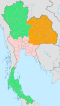
The Thai highlands or Hills of northern Thailand is a mountainous natural region in the north of Thailand. Its mountain ranges are part of the system of hills extending through Laos, Burma, and China and linking to the Himalayas, of which they may be considered foothills.

Topographical features within the Phitsanulok Province of Thailand include the Phetchabun Mountains, the Nan River and several of its tributaries, waterfalls, swamps, forests, grasslands, caves, a reservoir and an extensive network of canals. Populated areas of the province are largely cleared of natural vegetation and adapted for farming. The land in the province is in the Greater Nan Basin, which is part of the Chao Phraya Watershed. The province includes land within both of the greater Nan basin's sub-basins, i.e., the Nan Basin and Yom Basin. The provincial capital of Phitsanulok is sometimes called Song Kwae, the "city of two rivers", an ancient name dating to a time centuries ago when the Nan and Khwae Noi Rivers met near the city. These two rivers of the Phitsanulok Province are still of major significance to the residents of the region.

<span class="mw-page-title-main">Luang Prabang Range</span> Mountain range in northwestern Laos and northern Thailand

The Luang Prabang Range, named after Luang Prabang, is a mountain range straddling northwestern Laos and Northern Thailand. Most of the range is located in Sainyabuli Province (Laos), as well as Nan and Uttaradit Provinces (Thailand), with small parts in Phitsanulok and Loei Provinces. Several rivers such as the Nan, Pua and Wa rivers, have their sources in this range. Phu Fa waterfall, the biggest and the tallest waterfall in Nan Province, is also located in these mountains. This range is part of the Luang Prabang montane rain forests ecoregion.

<span class="mw-page-title-main">Phi Pan Nam Range</span> Mountain range in Thailand and Laos

The Phi Pan Nam Range, also Pee Pan Nam, is a 400 km (249 mi) long system of mountain ranges in the eastern half of the Thai highlands. The range lies mostly in Thailand, although a small section in the northeast is within Sainyabuli and Bokeo provinces of Laos.

<span class="mw-page-title-main">Thanon Thong Chai Range</span>

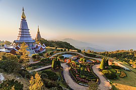
The Thanon Thong Chai Range is a mountain range in northern Thailand. Its tallest peak is Doi Inthanon, the highest point in Thailand. Most of the range is in Chiang Mai Province, with parts in Mae Hong Son and Lamphun Provinces.

Khao Yai–Khao Na Pha Tang and Khao Ta Phrom Non-hunting Area is a non-hunting area in Thong Saen Khan District of Uttaradit Province. It covers an area of 24 km2 (9.3 sq mi) and was established in 1984.

References

  1. 1 2 "ตารางที่ 2 พี้นที่ป่าไม้ แยกรายจังหวัด พ.ศ.2562" [Table 2 Forest area Separate province year 2019]. Royal Forest Department (in Thai). 2019. Retrieved 6 April 2021, information, Forest statistics Year 2019, Thailand boundary from Department of Provincial Administration in 2013{{cite web}}: CS1 maint: postscript (link)
  2. รายงานสถิติจำนวนประชากรและบ้านประจำปี พ.ส.2562 [Statistics, population and house statistics for the year 2019]. Registration Office Department of the Interior, Ministry of the Interior. stat.bora.dopa.go.th (in Thai). 31 December 2019. Retrieved 26 February 2020.
  3. "Gross Regional and Provincial Product, 2019 Edition". <>. Office of the National Economic and Social Development Council (NESDC). July 2019. ISSN   1686-0799 . Retrieved 22 January 2020.
  4. Tan, Heidi (2012), "The Many Streams of Buddhist Art in Thailand", Enlightened Ways: The Many Streams of Buddhist Art in Thailand, Asian Art Museum of San Francisco, p. 13
  5. Smith, John (2019). State, Community, and Ethnicity in Early Modern Thailand, 1351-1767 (PDF) (Ph.D. dissertation). University of Michigan. p. 40. Retrieved 2023-04-08.
  6. Forest data: Thailand Deforestation Rates
  7. Northern Thailand Archived 2012-01-28 at the Wayback Machine
  8. ดร.กระมล ทองธรรมชาติ และคณะ, สังคมศึกษา ศาสนาและวัฒนธรรม ม.1, สำนักพิมพ์ อักษรเจริญทัศน์ อจท. จำกัด, 2548, หน้า 24-25
  9. Phitsanulok Provincial Statistical Report 2562-2019: Economic Statistics - National Accounts. Phitsanulok Provincial Statistical Office (Report). National Statistical Office (NSO). 2020. pp. 94–95. ISSN   1905-8314.

19°N99°E / 19°N 99°E / 19; 99