Norwood, Colorado

Last updated

Norwood, Colorado
Grand Avenue in Norwood, Colorado.JPG
Grand Avenue, Norwood's main street
San Miguel County Colorado Incorporated and Unincorporated areas Norwood Highlighted 0854880.svg
Location of Norwood in San Miguel County, Colorado.
Coordinates: 38°7′52″N108°17′29″W / 38.13111°N 108.29139°W / 38.13111; -108.29139
Country Flag of the United States (23px).png  United States
State Flag of Colorado.svg  Colorado
County [1] San Miguel
Incorporated (town) August 20, 1903 [2]
Government
  Type Statutory Town [1]
  State Representative Marc Catlin [3]
Area
[4]
  Total0.28 sq mi (0.73 km2)
  Land0.28 sq mi (0.73 km2)
  Water0.00 sq mi (0.00 km2)
Elevation
[5]
7,011 ft (2,137 m)
Population
 (2020)
  Total535
  Density1,900/sq mi (730/km2)
  [6]
Time zone UTC-7 (Mountain (MST))
  Summer (DST) UTC-6 (MDT)
ZIP code [7]
81423 (PO Box)
Area code 970
FIPS code 08-54880
GNIS feature ID 0186059
Website www.norwoodtown.com

Norwood is a Statutory Town in San Miguel County, Colorado, United States. The population was 535 at the 2020 census. [6]

Contents

A post office called Norwood has been in operation since 1887. [8] The community was named after Norwood, Missouri, the native home of a first settler. [9]

Geography

Norwood is located at 38°7′52″N108°17′29″W / 38.13111°N 108.29139°W / 38.13111; -108.29139 (38.131077, -108.291478). [10]

According to the United States Census Bureau, the town has a total area of 0.3 square miles (0.78 km2), all land.

Norwood's rural location on Wright's Mesa led to its 2019 designation as an International Dark Sky Community by the International Dark-Sky Association. [11] Norwood is one of 32 International Dark Sky Communities. [12] Norwood's State Representative, Marc Catlin, passed legislation, Support Dark Sky Designation and Promotion in Colorado, which established the Colorado Designated Dark Sky designation. [13]

Demographics

Historical population
CensusPop.Note
1910 212
1920 36572.2%
1930 299−18.1%
1940 41237.8%
1950 294−28.6%
1960 44350.7%
1970 408−7.9%
1980 47817.2%
1990 429−10.3%
2000 4382.1%
2010 51818.3%
2020 5353.3%
United States Census Bureau

As of the census [14] of 2000, there were 438 people, 195 households, and 112 families residing in the town. The population density was 1,709.7 inhabitants per square mile (660.1/km2). There were 258 housing units at an average density of 1,007.1 units per square mile (388.8 units/km2). The racial makeup of the town was 97.49% White, 1.60% Native American, 0.23% from other races, and 0.68% from two or more races. Hispanic or Latino of any race were 5.48% of the population.

There were 195 households, out of which 27.2% had children under the age of 18 living with them, 45.6% were married couples living together, 6.7% had a female householder with no husband present, and 42.1% were non-families. 35.4% of all households were made up of individuals, and 7.7% had someone living alone who was 65 years of age or older. The average household size was 2.25 and the average family size was 2.92.

In the town, the population was spread out, with 24.4% under the age of 18, 10.0% from 18 to 24, 32.0% from 25 to 44, 25.3% from 45 to 64, and 8.2% who were 65 years of age or older. The median age was 38 years. For every 100 females, there were 105.6 males. For every 100 females age 18 and over, there were 95.9 males.

The median income for a household in the town was $39,375, and the median income for a family was $50,313. Males had a median income of $33,750 versus $22,813 for females. The per capita income for the town was $19,687. None of the families and 5.6% of the population were living below the poverty line, including no under eighteens and 20.6% of those over 64.

Notable people

See also

Related Research Articles

<span class="mw-page-title-main">Ouray County, Colorado</span> County in Colorado, United States

Ouray County is a county located in the U.S. state of Colorado. As of the 2020 census, the population was 4,874. The county seat is Ouray. Because of its rugged mountain topography, Ouray County is also known as the "Switzerland of America".

<span class="mw-page-title-main">Montrose County, Colorado</span> County in Colorado, United States

Montrose County is a county located in the U.S. state of Colorado. As of the 2020 census, the population was 42,679. The county seat is Montrose, for which the county is named.

<span class="mw-page-title-main">Montezuma County, Colorado</span> County in Colorado, United States

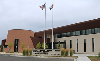
Montezuma County is a county located in the southwest corner of the U.S. state of Colorado. As of the 2020 census, the population was 25,849. The county seat is Cortez.

<span class="mw-page-title-main">Hinsdale County, Colorado</span> County in Colorado, United States

Hinsdale County is a county located in the U.S. state of Colorado. As of the 2020 census, the population was 788, making it the second-least populous county in Colorado. With a population density of only 0.71 inhabitants per square mile (0.27/km2), it is also the least-densely populated county in Colorado. The county seat and only incorporated municipality in the county is Lake City. The county is named for George A. Hinsdale, a prominent pioneer and former Lieut. Governor of Colorado Territory.

<span class="mw-page-title-main">Dolores County, Colorado</span> County in Colorado, United States

Dolores County is a county located in the U.S. state of Colorado. As of the 2020 census, the population was 2,326. The county seat is Dove Creek.

<span class="mw-page-title-main">Delta County, Colorado</span> County in Colorado, United States

Delta County is a county located in the U.S. state of Colorado. As of the 2020 census, the population was 31,196. The county seat is Delta.

<span class="mw-page-title-main">Brighton, Colorado</span> City in Colorado, United States

Brighton is a home rule municipality city located in Adams and Weld counties, Colorado, United States. Brighton is the county seat of Adams County and a part of the Denver–Aurora–Lakewood, CO Metropolitan Statistical Area and the Front Range Urban Corridor. The city population was 40,083 at the 2020 United States Census with 39,718 residing in Adams County and 365 residing in Weld County.

<span class="mw-page-title-main">Cheyenne Wells, Colorado</span> Town in Colorado, United States

Cheyenne Wells is the Statutory Town that is the county seat and the most populous municipality of Cheyenne County, Colorado, United States. The town population was 758 at the 2020 United States Census.

<span class="mw-page-title-main">Silver Cliff, Colorado</span> Town in Custer County, Colorado, United States

The Town of Silver Cliff is the Statutory Town that is the most populous municipality in Custer County, Colorado, United States. The population was 609 at the 2020 census, up from 587 in 2010.

<span class="mw-page-title-main">Dolores, Colorado</span> Town in Montezuma County, Colorado, United States

Dolores is a Statutory Town located in Montezuma County, Colorado, United States. The town population was 885 at the 2020 United States Census.

<span class="mw-page-title-main">Manzanola, Colorado</span> Town in Otero County, Colorado, United States

Manzanola is a Statutory Town in Otero County, Colorado, United States. The town population was 341 at the 2020 United States Census.

<span class="mw-page-title-main">Granada, Colorado</span> Town in Colorado, United States

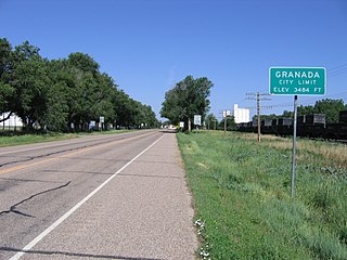
Granada is a Statutory Town in Prowers County, Colorado, United States. The town population was 445 at the 2020 United States Census.

<span class="mw-page-title-main">Roopville, Georgia</span> Town in Georgia, United States

Roopville is a town in Carroll County, Georgia, United States. The population was 218 at the 2010 census.

Catlin is a town in Chemung County, New York, United States. The population was 2,554 at the 2020 census. The town is named after Phineas Catlin, a surveyor and public official. Catlin is in the northwestern corner of the county, northwest of Elmira. It is part of the Elmira Metropolitan Statistical Area.

<span class="mw-page-title-main">Madrid, New York</span> Town in New York, United States

Madrid is a town in St. Lawrence County, New York. The population was 1,735 at the time of the 2010 census. The town is named after the capital of Spain. Madrid is in the northern part of the county, north of Canton.

<span class="mw-page-title-main">Norwood, New York</span> Village in New York, United States

Norwood is a village located in St. Lawrence County, New York, United States. As of the 2010 census, the village had a total population of 1,560. The village is located partly in two towns, Potsdam and of Norfolk, and located is east of the village of Potsdam.

<span class="mw-page-title-main">North Woodbury Township, Pennsylvania</span> Township in Pennsylvania, United States

North Woodbury Township is a township in Blair County, Pennsylvania, United States. It is part of the Altoona, PA Metropolitan Statistical Area. The population was 2,434 at the 2020 census.

<span class="mw-page-title-main">Sardis, Tennessee</span> Town in Tennessee, United States

Sardis is a town in Henderson County, Tennessee, United States. The population was 381 at the 2010 census.

<span class="mw-page-title-main">Norfolk, New York</span> Town in New York, United States

Norfolk is a town in St. Lawrence County in the U.S. state of New York. The town is in the northern part of the county and is north of Potsdam. The population was 4,453 at the 2020 census.

<span class="mw-page-title-main">Dripping Springs, Texas</span> City in Texas, United States

Dripping Springs is a city in Hays County, Texas, United States. The population was 4,650 at the 2020 census. Dripping Springs is a primarily rural town.

References

  1. 1 2 "Active Colorado Municipalities". State of Colorado, Department of Local Affairs. Archived from the original on December 12, 2009. Retrieved September 1, 2007.
  2. "Colorado Municipal Incorporations". State of Colorado, Department of Personnel & Administration, Colorado State Archives. December 1, 2004. Retrieved September 2, 2007.
  3. "State Representative". State of Colorado. Retrieved January 3, 2024.
  4. "2019 U.S. Gazetteer Files". United States Census Bureau. Retrieved July 1, 2020.
  5. "US Board on Geographic Names". United States Geological Survey. October 25, 2007. Retrieved January 31, 2008.
  6. 1 2 United States Census Bureau. "Norwood town, Colorado" . Retrieved February 17, 2023.
  7. "ZIP Code Lookup". United States Postal Service. Archived from the original (JavaScript/HTML) on September 3, 2007. Retrieved November 26, 2007.
  8. "Post offices". Jim Forte Postal History. Retrieved July 1, 2016.
  9. Dawson, John Frank. Place names in Colorado: why 700 communities were so named, 150 of Spanish or Indian origin. Denver, CO: The J. Frank Dawson Publishing Co. p. 37.
  10. "US Gazetteer files: 2010, 2000, and 1990". United States Census Bureau. February 12, 2011. Retrieved April 23, 2011.
  11. "Norwood, Colorado (U.S.)". International Dark-Sky Association. Retrieved August 19, 2021.
  12. "International Dark Sky Communities". International Dark-Sky Association. Retrieved August 19, 2021.
  13. Donovan, Kerry; Catlin, Marc; McCluskie, Julie, Support Dark Sky Designation And Promotion In Colorado , retrieved January 4, 2024
  14. "U.S. Census website". United States Census Bureau . Retrieved January 31, 2008.
  15. "Robert B. Duffield ’40", Princeton Alumni Weekly . Accessed August 31, 2020. "Bob died at his home in Norwood, Colo., on Dec. 26, 2000, after a brief illness with acute leukemia. He prepared at Asbury Park H.S."
  16. Lofholm, Nancy. "Peak Honors Are Slated For Western Colorado Mountaineers Who Died Climbing In 2006". Colorado Public Radio. Retrieved August 19, 2021.