
The demographic characteristics of the population of Croatia are known through censuses, normally conducted in ten-year intervals and analysed by various statistical bureaus since the 1850s. The Croatian Bureau of Statistics has performed this task since the 1990s. The latest census in Croatia was performed in autumn of 2021. According to final results published on 22 September 2022 the permanent population of Croatia at the 2021 census had reached 3.87 million. The population density is 68.7 inhabitants per square kilometre, and the overall life expectancy in Croatia at birth was 78,2 years in 2018. The population rose steadily from 2.1 million in 1857 until 1991, when it peaked at 4.7 million. Since 1991, Croatia's death rate has continuously exceeded its birth rate; the natural growth rate of the population is negative. Croatia is in the fourth stage of the demographic transition. In terms of age structure, the population is dominated by the 15 to 64 year‑old segment. The median age of the population is 43.4, and the gender ratio of the total population is 0.93 males per 1 female.

Slatina is a town in the Slavonia region of Croatia. It is located in the Virovitica-Podravina County, at the contact of the Drava valley and the foothills of Papuk mountain, in the central part of the region of Podravina, 29 km (18 mi) southeast of Virovitica; elevation 127 metres. It was ruled by Ottoman Empire between 1542 and 1687, when it was captured by Austrian troops. During Ottoman rule it was initially part of Sanjak of Pojega between 1542 and 1601, latterly part of Sanjak of Rahoviçe between 1601 and 1687. It was district centre at Virovitica County in Kingdom of Croatia-Slavonia between 1868 and 1918.
Bjelovar-Bilogora County is a county in central Croatia.

Istria County is the westernmost county of Croatia which includes the biggest part of the Istrian peninsula.

Primorje-Gorski Kotar County is a county in western Croatia, most of it based in the historical and cultural region called Croatia proper and some of it in Istria, that includes the Bay of Kvarner, the surrounding Northern Croatian Littoral, and the mountainous region of Gorski kotar. Its center is Rijeka. The county's population was 296,195 at the 2011 census.

Lika-Senj County is a county in Croatia that includes most of the Lika region and some northern coastline of the Adriatic near the town of Senj, including the northern part of the Pag island. Its center is Gospić.

Šibenik-Knin County is a county in southern Croatia, located in the north-central part of Dalmatia. The biggest city in the county is Šibenik, which also serves as county seat. Other notable towns in the county are Knin, Vodice, Drniš and Skradin.

Brod-Posavina County is the southern Slavonian county in Croatia. Its center is the city of Slavonski Brod and it spreads along the left bank of the Sava river, hence the name Posavina. Other notable towns include Nova Gradiška.

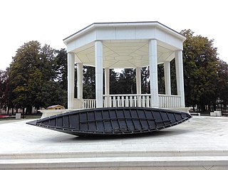
The Dubrovnik-Neretva County is the southernmost county of Croatia. The county seat is Dubrovnik and other large towns are Korčula, Metković, Opuzen and Ploče. The Municipality of Neum, which belongs to neighbouring Bosnia and Herzegovina, divides the county in two parts which are connected only by the Pelješac Bridge. The southern part of the county consists of Dubrovnik and the surrounding area, including the Pelješac peninsula, and the islands of Korčula, Lastovo, Mljet, Šipan, Lopud and Koločep. The northern part of the county includes the Neretva Delta, the Baćina lakes north of Ploče, and a swath of hinterland near the southernmost slopes of Biokovo and around the hill of Rujnica. The northern part of the Mljet island is a national park. The Lastovo archipelago is a designated nature park. The southernmost tip of the county is the Prevlaka peninsula at the border with Montenegro. It is the only Croatian county that borders Montenegro.

Ploče is a town and seaport in the Dubrovnik-Neretva County of Croatia.

Sesvete is the easternmost city district of Zagreb, Croatia.

Ivanić-Grad or Ivanić Grad is a town in Zagreb County, Croatia. It is on the border of Moslavina and Posavina.

Radini is a village in the Brtonigla municipality in Istria County, Croatia.

Karigador is a village in the Brtonigla municipality in Istria County, Croatia.
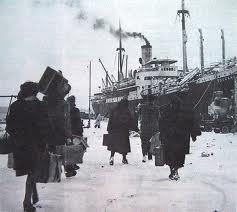
The Italian language is an official minority language in Croatia, with many schools and public announcements published in both languages. Croatia's proximity and cultural connections to Italy have led to a relatively large presence of Italians in Croatia. Italians were recognized as a state minority in the Croatian Constitution in two sections: Istrian Italians and Dalmatian Italians. Although only 0.43% of the total population is Italian by citizenship, many more are ethnically Italian and a large percentage of Croatians speak Italian, in addition to Croatian.

Istrian Italians are an ethnic group from the Adriatic region of Istria in modern northwestern Croatia and southwestern Slovenia. Istrian Italians descend from the original Latinized population of Roman Histria, from the Venetian-speaking settlers who colonized the region during the time of the Republic of Venice, and from the local Croatian people who culturally assimilated.

Italians of Croatia are an autochthonous historical national minority recognized by the Constitution of Croatia. As such, they elect a special representative to the Croatian Parliament. There is Italian Union of Croatia and Slovenia, in Croat Talijanska Unija, in Slovene Italijanska Unija, which is Croat-Slovene organization with main site in Fiume-Rijeka and secondary site in Capodistria-Koper of Slovenia.
Baredine is a village in Istria County in Croatia. Administratively it belongs to Buzet.
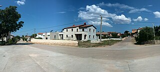
Fiorini is a village in the Brtonigla municipality in Istria County, Croatia.

