Nubra

Last updated

Nubra
region
5 Nubra valley.jpg
Nubra Valley with Diskit Gompa and town immediately below and Hunder in the distance
India Ladakh location map UN view.svg
Red pog.svg
Nubra
Location in Ladakh, India
India location map.svg
Red pog.svg
Nubra
Nubra (India)
Coordinates: 34°36′N77°42′E / 34.6°N 77.7°E / 34.6; 77.7
CountryFlag of India.svg  India
Union Territory Ladakh
District Leh
Time zone UTC+5:30 (IST)

Nubra, also called Dumra, is a historical region of Ladakh, India [1] that is currently administered as a subdivision and a tehsil in the Leh district. Its inhabited areas form a tri-armed valley cut by the Nubra and Shyok rivers. Its Tibetan name Dumra means "valley of flowers". [2] Demands have been raised and BJP has hinted at creation of Nubra as a new district. [3] Diskit, the headquarters of Nubra, is 120 km north of Leh, the capital of Ladakh.

Contents

The Shyok River meets the Nubra River (or Siachan River) to form a large valley that separates the Ladakh and Karakoram Ranges. The Shyok river is a tributary of the Indus river. The average altitude of the valley is more than 10,000 feet (3,000 m) above the sea level. The most common way to access this valley is to travel over the Khardung La pass from Leh.

Foreign nationals are required to get a Protected area permit to visit Nubra. Since 1 April 2017 Indian citizens are also required to get an Inner Line Permit to visit it. [4] [ unreliable source? ]

Name

Nubra (Tibetan : ནུབ་ར, Wylie : nub ra, THL : nup ra) means "western" in Ladakhi, thus referring to the "western valley", perhaps distinguishing it from the thinly-populated eastern Shyok river valley. The traditional name of the region is Dumra (Tibetan : ལྡུམ་ར, Wylie : ldum ra, THL : dum ra), meaning "valley of flowers". [2]

Geography

The region of Nubra is drained by the Shyok and Nubra rivers Shyok2.svg
The region of Nubra is drained by the Shyok and Nubra rivers

Alexander Cunningham listed Nubra as one of the five natural and historical divisions of Ladakh. [5] Nubra occupies the northeastern portion of Ladakh, bordering Baltistan and Chinese Turkestan in the north, and the Aksai Chin plateau and Tibet in the east. In Cunningham's conception, Nubra includes all the region drained by the Nubra and Shyok rivers. it is 128 miles long and 72 miles wide, making up an area of 9,200 square miles. It extends south till the Pangong Lake. [6]

In modern nomenclature, the Nubra region is divided into "Diskit Nubra" in the north and the "Darbuk region" in the south, both of which are regarded as tehsils and subdivisions of the Leh district. [7] The Diskit Nubra region includes the Turtuk block populated by Balti people, which became a part of Indian-administered Kashmir after the Indo-Pakistani War of 1971, and the unpopulated Siachen Glacier region. [8]

The populated part of Nubra is often described as a "tri-armed valley", [9] the three arms being: [10]

The eastern Shyok valley is mostly unpopulated, even though it has numerous camping sites that have been used by trade caravans. Murgo is a village on the tributary called Murgo Nala.

Topography

The topography of Ladakh India Ladakh With Some Features.png
The topography of Ladakh

Like the rest of the Tibetan Plateau, Nubra is a high altitude cold desert with rare precipitation and scant vegetation except along river beds. The villages are irrigated and fertile, producing wheat, barley, peas, mustard and a variety of fruits and nuts, including blood apples, walnuts, apricots and even a few almond trees. Most of Nubra is inhabited by Nubra dialect or Nubra Skat speakers. The majority are Buddhists. In the western or lowest altitude end of Nubra near the Line of Control i.e. the Indo-Pak border, along the Shyok River, the inhabitants of Turtuk are Balti of Gilgit-Baltistan, who speak Balti, and are Shia and Sufia Nurbakhshia Muslims.

Siachen Glacier lies to the north of the valley. The Sasser Pass and the famous Karakoram Pass lie to the northwest of the valley and connect Nubra with Uyghur (Mandarin : Xinjiang). Previously much trade passed through the area towards western China's Xinjiang and Central Asia. The people of Baltistan also used the Nubra valley for passage to Tibet. [11]

Places

Diskit town in the valley have become the congregation centre for people of the region. Diskit is the headquarters of Nubra and thus has lot of government offices with basic facilities. It is also connected by road with Leh.

Along the Nubra or Siachan River lie the villages of Sumur, Kyagar (called Tiger Hill by the Indian Army), Tirith, Panamik, Turtuk and many others.

Travel routes

Historical trade routes through Nubra and Aksai Chin (Sketch map by Henry Trotter, 1878) Map of Tibet and Pangong Lake in 1873 from Hindutagh-pass-aksai-chin-center2-1873 (cropped).jpg
Historical trade routes through Nubra and Aksai Chin (Sketch map by Henry Trotter, 1878)

The main road access to Nubra is over Khardung La which is open throughout the year. The highest elevation of Khardung La is 5,359 m (17,582 ft), its status as the highest motorable road in the world is no longer accepted by most authorities. [12] An alternative route, opened in 2008, crosses the Wari La from Sakti, to the east of Khardung La, connecting to the main Nubra road system via Agham and Khalsar along the Shyok River. There are also trekkable passes over the Ladakh Range from the Indus Valley at various points. Routes from Nubra to Baltistan and Yarkand, though historically important, have been closed since 1947 and 1950 respectively.

Tourism

Tourists riding Bactrian camels in Hundar Tourists riding bactrian camels.jpg
Tourists riding Bactrian camels in Hundar
Sand Dunes of Nubra valley. Nubra Sand Dunes.jpg
Sand Dunes of Nubra valley.

The Nubra valley was open for tourists up to Hunder (the land of sand dunes) until 2010. The region beyond Hunder gives way to a greener region of Ladakh because of its lower altitude. The village of Turtuk which was unseen by tourists till 2010 is a virgin destination for people who seek peace and an interaction with a tribal community of Ladakh. The local Balti people follow their age old customs in their lifestyle and speak a language which oral and not yet written. For tourists Turtuk offers serene camping sites with environment friendly infrastructure.

Panamik is noted for its hot springs. Between Hundar and Diskit lie seven kilometres of sand dunes, and (two-humped) Bactrian camels graze in the neighbouring "forests" of seabuckthorn. Non-locals are not allowed below Hundar village into the Balti area, as it is a border area.

Monasteries

Maitreya - 33 metre symbol of peace facing West. Nubra Valley Maitreya Buddha, Nubra.jpg
Maitreya - 33 metre symbol of peace facing West. Nubra Valley

The 32-metre Maitreya Buddha statue is the landmark of Nubra and is maintained by the Diskit Monastery. On the Shyok River, the main village, Diskit, is home to the dramatically positioned Diskit Monastery which was built in 14th century. Hundar was the capital of the erstwhile Nubra kingdom in the 17th century, and is home to the Chamba Gompa.

Samstanling Monastery is between Kyagar and Sumoor villages. Across the Nubra or Siachan River at Panamik, is the isolated Ensa Gompa.

Yarma Gompa, between Saser and Siachen Base Camp, is one of the large monastery belonging to the Drukpa Kagyu lineage and it manages the following village gompas, Tong-sted, Nyung-sted, Dungsa, Khemi, Tsang-lung-ka, Sarsoma, Aarunuk, Ayi, Kovet, Tangsa & Murgo. The senior to lower hierarchy of gompa administration is Lopon, Gye-nyen, Geylong, Gye-tsul, and cun-zung. [13]

Flora and fauna

The valley is famous for its forest of Hippophae shrub, popularly known as Leh Berry. It is within this shrub forest that one can spot the white-browed tit-warbler. One can also spot the Tibetan lark, Hume's short-toed lark, and Hume's whitethroat. The various water birds like ruddy shelduck, garganey, northern pintail, and mallard can be observed on several small water bodies scattered along the route. Besides these, waders like black-tailed godwit, common sandpiper, common greenshank, common redshank, green sandpiper, and ruff can be spotted in Nubra. [14]

Education

The valley has been secluded as has been most of the exterior parts of Ladakh. Almost all of the region has been facing problems to get good quality education. There have been initiatives in the past by the government but extreme weather conditions and vicinity to the borders have been a major hurdle in implementing a solid education base. There is also migration of the population that gets exposed to the big cities of India and hence the people do not get benefitted out of their local learned population. There are very few Non-Government organizations active in Nubra region.

Nubra valley was appeared, mentioned in Hollywood movie Mission Impossible : Fallout of Tom Cruise. In the film's climax Ethan Hunt (Cruise) stop Walker (Henry Cavill) from detonating Plutonium bomb at the base of Siachen glacier . However filming of the scene was done in New Zealand due to India government denied filming. [15]

See also

Notes

  1. Yarma is the upper part of the valley above Panamik, Tsurka is the right bank of the valley below Panamik, while Yarma is the left bank.

Related Research Articles

<span class="mw-page-title-main">Ladakh</span> Region administered by India

Ladakh is a region administered by India as a union territory and constitutes an eastern portion of the larger Kashmir region that has been the subject of a dispute between India and Pakistan since 1947 and India and China since 1959. Ladakh is bordered by the Tibet Autonomous Region to the east, the Indian state of Himachal Pradesh to the south, both the Indian-administered union territory of Jammu and Kashmir and the Pakistan-administered Gilgit-Baltistan to the west, and the southwest corner of Xinjiang across the Karakoram Pass in the far north. It extends from the Siachen Glacier in the Karakoram range to the north to the main Great Himalayas to the south. The eastern end, consisting of the uninhabited Aksai Chin plains, is claimed by the Indian Government as part of Ladakh, and has been under Chinese control since 1962.

<span class="mw-page-title-main">Baltistan</span> Region of Pakistani-administered Kashmir

Baltistan also known as Baltiyul or Little Tibet, is a mountainous region in the Pakistani-administered territory of Gilgit–Baltistan. It is located near the Karakoram and borders Gilgit to the west, China's Xinjiang to the north, Indian-administered Ladakh to the southeast, and the Indian-administered Kashmir Valley to the southwest. The average altitude of the region is over 3,350 metres (10,990 ft). Baltistan is largely administered under the Baltistan Division.

<span class="mw-page-title-main">Kargil district</span> District of Indian-administered Ladakh, Kashmir region

Kargil district is a district in Indian-administered Ladakh in the disputed Kashmir-region. It is one of the two districts comprising the Indian-administered union territory of Ladakh. The district headquarters are in the city of Kargil. The district is bounded by the Indian-administered union territory of Jammu and Kashmir to the west, the Pakistani-administered administrative territory of Gilgit–Baltistan to the north, Ladakh's Leh district to the east, and the Indian state of Himachal Pradesh to the south. Encompassing three historical regions known as Purig, Dras and Zanskar, the district lies to the northeast of the Great Himalayas and encompasses the majority of the Zanskar Range. Its population inhabits the river valleys of the Dras, Suru, Wakha Rong, and Zanskar.

Khardung La or Khardung Pass is a mountain pass in the Leh district of the Indian union territory of Ladakh.

<span class="mw-page-title-main">History of Ladakh</span> Aspect of history

Ladakh has a long history with evidence of human settlement from as back as 9000 b.c. It has been a crossroad of high Asia for thousands of years and has seen many cultures, empires and technologies born in its neighbours. As a result of these developments Ladakh has imported many traditions and culture from its neighbours and combining them all gave rise to a unique tradition and culture of its own.

<span class="mw-page-title-main">Geography of Ladakh</span> Aspect of geography

Ladakh is an administrative territory of India that has been under its control since 1947. The geographical region of Ladakh union territory is the highest altitude plateau region in India, incorporating parts of the Himalayan and Karakoram mountain ranges and the upper Indus River and valley.

<span class="mw-page-title-main">Ladakh Range</span>

The Ladakh Range is a mountain range in central Ladakh in India with its northern tip extending into Baltistan in Pakistan. It lies between the Indus and Shyok river valleys, stretching to 230 miles (370 km). Leh, the capital city of Ladakh, is on the foot of Ladakh Range in the Indus river valley.

<span class="mw-page-title-main">Tourism in Ladakh</span>

Tourism is one of an economic contributor to the union territory of Ladakh in Northern India. The union territory is sandwiched between the Karakoram mountain range to the north and the Himalayas to the south and is situated at the height of 11,400 ft. Ladakh is composed of the Leh and Kargil districts. The region contains prominent Buddhist sites and has an ecotourism industry.

<span class="mw-page-title-main">Shyok River</span> River in India and Pakistan

The Shyok River is a tributary of the Indus River that flows through northern Ladakh and enters Gilgit–Baltistan, spanning some 550 km (340 mi).

<span class="mw-page-title-main">Nubra River</span> River in India

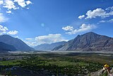
The Nubra River is a river in the Nubra Valley of Ladakh in India. It is a tributary of the Shyok River and originates from the Siachen Glacier, the second-longest non-polar glacier in the world. In earlier Tibetan maps, it was referred as Yarma Tsangpo.

<span class="mw-page-title-main">Diskit Monastery</span> Buddhist monastery in Ladakh, India

Diskit Monastery also known as Deskit Gompa or Diskit Gompa is the oldest and largest Buddhist monastery (gompa) in Diskit, Nubra Valley of the Leh district of Ladakh. It is 115 km north of Leh.

<span class="mw-page-title-main">Turtuk</span> Village in Ladakh, India

Turtuk is a village and the headquarters of an eponymous community development block in the Indian union territory of Ladakh. It is a small village sandwiched between the Karakorum Range and the Himalayas, and one of the northernmost villages of India, close to the Line of Control between India and Pakistan. Turtuk is situated in the Nubra tehsil of the Leh district, on the banks of the Shyok River. Geographically, the village is in the Baltistan region, which has been under Pakistani administration, except for five villages of the Turtuk block which are part of India. These villages form the only region in India populated by Balti people. Turtuk is known for its fruit, especially apricots.

<span class="mw-page-title-main">Chorbat Valley</span> Valley in Gilgit-Baltistan & Ladakh, Pakistan & India

Chorbat Valley is a section of the Shyok river valley divided between Pakistan-administered Gilgit-Baltistan and Indian-administered Ladakh. The Pakistan-administered portion is in the Khaplu tehsil of Ghanche District in Gilgit–Baltistan, and the Indian-administered portion is in the Nubra tehsil, Leh district of Ladakh. Chorbat stretches from the edge of Khaplu to the Chalunka village of Nubra.

<span class="mw-page-title-main">Murgo</span> Village in Ladakh, India

Murgo, on "Murgo Nala" near Murgo Hotspring, is a small hilly village which lies near the Line of Actual Control in Leh district of the union territory of Ladakh in India, close to Chinese-controlled Aksai Chin. It is one of the northernmost villages of India. The Murgo Gompa is a large Buddhist monastery at Murgo. Murgo lies on the Darbuk–Shyok–DBO Road and Sasser Brangsa-Murgo Road fork of Sasoma–Sasser La-Saser Brangsa-Gapsam-Daulat Beg Oldi Road, both of which connect Leh to Daulat Beg Oldi. The village is inhabited by a small civilian population of Baltis, who make a living by apricot farming and yak rearing. The temperature plummets as low as -30 C in the winters. The weather deteriorates frequently with strong icy winds lashing much of Murgo. Murgo has very little vegetation or wildlife. Telecommunication at Murgo is only available through INMARSAT satellite phones. The Indian Armed Forces have significant presence in the area.

All Ladakh Gonpa Association (ALGA) is the central organisation of the Buddhist monasteries in Ladakh, India. It aims to preserve and strengthen the monastic institutions. It was founded by the 19th Kushok Bakula Rinpoche in 1949 and he acted as its president for 41 years, from 1949 until 1991. In 1949, the first meeting of the great monasteries was held and ten monasteries took part. All Ladakh Gonpa Association was registered in 1959 and is run by a governing body consisting of fifteen lama members belonging to all four major schools of Tibetan Buddhism. There are sixteen major monastic institutions with hundreds of monks in each monastery.

Bogdang is a village in the Leh district of Ladakh, India. It is located in Nubra tehsil.

Tangtse or Drangtse (Tibetan: བྲང་རྩེ, Wylie: brang rtse, THL: drang tsé) is a village in the Leh district of Ladakh, India. It is located in the Durbuk tehsil. Traditionally, it was regarded as the border between the Nubra region to the north and the Pangong region to the south. It was a key halting place on the trade route between Turkestan and Tibet. It was also a site of wars between Ladakh and Tibet.

Durbuk or Darbuk, is a village and the headquarters of the eponymous subdivision and block in the Leh district of Ladakh, India. It is located in the Durbuk tehsil, and falls between Chang La mountain pass and Tangste village on the way to Pangong Tso Lake.

<span class="mw-page-title-main">Hundar, India</span> Village in Ladakh, India

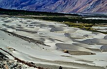
Hundar is a village in the Leh district of Ladakh, India, famous for sand dunes and Bactrian camels. It is located in the Nubra tehsil, on the banks of the Shyok River. The Hunder Monastery is located here.

The Battle of Turtuk was a military engagement between India and Pakistan that took place during the Indo-Pakistani War of 1971. Fighting between the two sides took place in Turtuk and its surrounding areas, then part of the Pakistani-administered Northern Areas in Kashmir. Following this battle, Indian forces captured Turtuk from Pakistan, which had controlled the area since the Indo-Pakistani War of 1947–1948. Per the Simla Agreement, Turtuk was incorporated into the erstwhile Indian-administered state of Jammu and Kashmir, and formally became a part of Ladakh following the revocation of Article 370 by the Government of India in August 2019.

References

  1. Shakabpa, One Hundred Thousand Moons (2009) , pp. 583–584: "The Tibetan soldiers pursued the remaining troops as far as a place called Dumra,[10: These days, Dumra is called Nupra] just one day’s journey from Leh, where the Tibetan army pitched their camp."
  2. 1 2 Kapadia, Harish (1999). Across Peaks & Passes in Ladakh, Zanskar & East Karakoram. Indus Publishing. p. 230. ISBN   978-81-7387-100-9.
  3. 3,000 Demonstrate for Separate District in Sub-Zero Temperatures at Kargil, The Wire, 06/FEB/2020.
  4. People, Attractions & Transportation in Nubra Valley, The Off: Leh Ladakh XP (Jai Kishan), 17 March 2021.
  5. Cunningham, Ladak (1854) , p. 18: "The natural divisions of the country are: 1st, Nubra on the Shayok; 2nd, Ladak Proper, on the Indus; 3rd, Zanskar, on the Zanskar river; 4th, Rukchu [Rupshu], around the lakes of Tshomo Riri [Tso Moriri] and Tsho-Kar; 5th, Purik, Suru, and Dras, on the different branches of the Dras river; 6th, Spiti, on the Spiti river: and 7th, Lahul, on the Chandra and Bhaga, or head-waters of the Chenab. These also are the actual divisions of the country, for the natural boundaries of a mountainous district generally remain unaltered, in spite of the changes wrought by war and religion. Ladak is divided politically between Maharaja Gulab Sing and the East-India Company. To the former belong all the northern districts, to the latter only the two southern districts of Lahul and Spiti."
  6. Cunningham, Ladak (1854), p. 21.
  7. Tehsil, Leh district administration, retrieved 15 November 2020.
  8. Muhammad Raafi, Interview of Delan Namgial, Kashmiri Life, 17 January 2017.
  9. Sumedha Das, Paradise on Earth, The Statesman, 24 November 2019.
  10. 1 2 Vohra, Mythic Lore from Nubra Valley (1990), pp. 225–226.
  11. Senge H. Sering, “Reclaiming Nubra” – Locals Shunning Pakistani Influences Archived 8 July 2016 at the Wayback Machine , Institute for Defence Studies and Analyses, Delhi, 17 August 2009.
  12. "Nubra Valley - World's Finest Wool". www.worlds-finest-wool.com. Retrieved 10 January 2022.
  13. Prem Singh Jina, 2009, Cultural Heritage of Ladakh Himalaya, p 114.
  14. Khan, Asif (2016). "Ladakh: The Land Beyond". Buceros. 21 (3): 6–15.
  15. "Tom Cruise's MI..." Hindustan Times.

Bibliography