
RADARSAT-1 was Canada's first commercial Earth observation satellite. It utilized synthetic aperture radar (SAR) to obtain images of the Earth's surface to manage natural resources and monitor global climate change. As of March 2013, the satellite was declared non-operational and is no longer collecting data.

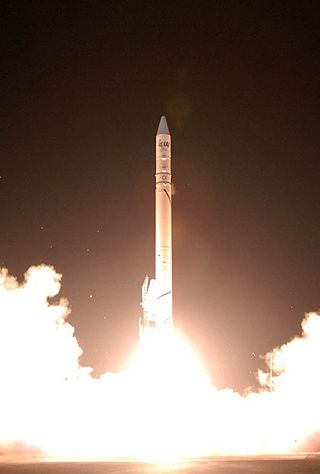
Vega is an expendable launch system in use by Arianespace jointly developed by the Italian Space Agency (ASI) and the European Space Agency (ESA). Development began in 1998 and the first launch took place from the Guiana Space Centre on 13 February 2012.

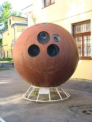
BYEMAN codenamed LANYARD, the KH-6 was the unsuccessful first attempt to develop and deploy a very high-resolution optical reconnaissance satellite by the United States National Reconnaissance Office. Launches and launch attempts spanned the period from March to July 1963. The project was quickly put together to get imagery of a site near Leningrad suspected of having anti-ballistic missiles. The satellite carried Itek's "E-5" camera developed for the SAMOS program, which had been cancelled. The camera had a focal length of 1.67 m and could discern objects on the ground 1.8 m in size. The ground swath of the camera was 14 km × 74 km. The satellite weighed 1,500 kg (3,300 lb), and had a single re-entry vehicle in which exposed film was returned to earth for a mid-air aircraft recovery. The KH-6 was manufactured by Lockheed Martin and launched from Vandenberg Air Force Base on Thor-Agena D launch vehicles.
Zenit was a series of military photoreconnaissance satellites launched by the Soviet Union between 1961 and 1994. To conceal their nature, all flights were given the public Kosmos designation.
Ofeq, also spelled Offek or Ofek is the designation of a series of Israeli reconnaissance satellites first launched in 1988. Most Ofeq satellites have been carried on top of Shavit 2 launch vehicles from Palmachim Airbase in Israel, on the Mediterranean coast. The low Earth orbit satellites complete one Earth orbit every 90 minutes.
Earth Resources Observation Satellite (EROS) is a series of Israeli commercial Earth observation satellites, designed and manufactured by Israel Aircraft Industries (IAI), with optical payload supplied by El-Op. The satellites are owned and operated by ImageSat International N.V. (ISI), a company founded in 1997, as a Joint venture between IAI, El-Op and Core Software Technology (CST). EROS A was launched on December 5, 2000 and EROS B on April 25, 2006.

SAR-Lupe is Germany's first reconnaissance satellite system and is used for military purposes. SAR is an abbreviation for synthetic-aperture radar, and "Lupe" is German for magnifying glass. The SAR-Lupe program consists of five identical (770 kg) satellites, developed by the German aeronautics company OHB-System, which are controlled by a ground station responsible for controlling the system and analysing the retrieved data. A large data archive of images will be kept in a former Cold War bunker belonging to the Kommando Strategische Aufklärung of the Bundeswehr. The total price of the satellites was over 250 million Euro.
Future Imagery Architecture (FIA) was a program awarded to Boeing to design a new generation of optical and radar imaging US reconnaissance satellites for the National Reconnaissance Office (NRO). In 2005 NRO director Donald Kerr recommended the project's termination, and the optical component of the program was finally cancelled in September 2005 by Director of National Intelligence John Negroponte. FIA has been called by The New York Times "perhaps the most spectacular and expensive failure in the 50-year history of American spy satellite projects." Despite the optical component's cancellation, the radar component, known as Topaz, has continued, with four satellites in orbit as of February 2016.
COSMO-SkyMed is an Earth-observation satellite space-based radar system funded by the Italian Ministry of Research and Ministry of Defence and conducted by the Italian Space Agency (ASI), intended for both military and civilian use. The prime contractor for the spacecraft was Thales Alenia Space. COSMO SkyMed is a constellation of four dual use Intelligence, surveillance, target acquisition, and reconnaissance (ISR) Earth observation satellites with a synthetic-aperture radar (SAR) as main payload, the result of the intuition of Giorgio Perrotta in the early nineties. The synthetic-aperture radar was developed starting in the late nineties with the SAR 2000 program funded by ASI.

TecSAR-1, also known as TechSAR, Polaris and Ofeq-8, is an Israeli reconnaissance satellite, equipped with a synthetic-aperture radar (SAR) developed by Elta Systems. It was successfully launched at 03:45 UTC on 21 January 2008, by PSLV C-10 launch vehicle, from the Satish Dhawan Space Centre in India.

Sentinel-1 is the first of the Copernicus Programme satellite constellations conducted by the European Space Agency. The mission was originally composed of a constellation of two satellites, Sentinel-1A and Sentinel-1B, which shared the same orbital plane. Two more satellites, Sentinel-1C and Sentinel-1D are in development. Sentinel-1B was retired following a power supply issue on December 23, 2021, leaving Sentinel-1A the only satellite of the constellation currently operating. Sentinel-1C is currently planned to launch in the final quarter of 2024.

RISAT (Radar Imaging Satellite) is a series of Indian radar imaging reconnaissance satellites built by the Indian Space Research Organization (ISRO). They provide all-weather surveillance using synthetic aperture radars (SAR).
SEOSat-Ingenio, was a Spanish project to produce a satellite capable of providing wide-field imagery ensuring a repeat cycle of 38 days at 2.5 metre panchromatic resolution and 10 metre colour resolution, from a Sun-synchronous polar orbit; it was Spain's first optical imaging satellite. The satellite was part of the Spanish Earth Observation Satellite program. The mission was funded by Spain's Centre for the Development of Industrial Technology (CDTI). SEOSat-Ingenio information was to be used by various Spanish civil, institutional or government users. However, under the Copernicus Programme of the European Union, it was also accessible to other European users, as well as to the Group on Earth observation of the Global Observing System of Earth.

Göktürk-1 is a high resolution Earth observation satellite designed and developed for the Turkish Ministry of National Defence by the Italian space service company Telespazio with technological input from Turkish Aerospace Industries (TUSAŞ) and ASELSAN of Turkey.

Vegetation and Environment monitoring on a New Micro-Satellite (VENμS) is a near polar Sun-synchronous orbit microsatellite. It is a joint project of the Israeli Space Agency and CNES. The project was signed upon in April 2005 and was launched on the 2nd of August 2017. The microsatellite, which was set to cost the ISA US$20 million and CNES €10 million, was designed and built by IAI and Rafael under ISA's supervision.
Ofeq-11, also known as Ofek 11, is part of the Ofeq family of reconnaissance satellites designed and built by Israel Aerospace Industries (IAI) for the Israeli Ministry of Defense.

PSLV-C42 was the 44th mission of the Indian Polar Satellite Launch Vehicle (PSLV) program and its 12th mission in the Core Alone (CA) configuration. PSLV-C42 successfully carried and deployed 2 Earth observation satellites in Sun-synchronous orbits at an altitude of 588 kilometres (365 mi). It was launched on 16 September 2018 by the Indian Space Research Organisation (ISRO) from the first launch pad of the Satish Dhawan Space Centre at Sriharikota, Andhra Pradesh. The two international satellites were launched as part of a commercial arrangement between Surrey Satellite Technology Limited (SSTL) and ISRO's commercial arm Antrix Corporation Limited, run under the auspices of the Indian Government's Department of Space.
The Mohammed VI satellites are a series of two Moroccan Earth observation and reconnaissance satellites, namely Mohammed VI-A and Mohammed VI-B, developed and built by Airbus Defence and Space and Thales Alenia Space based upon the Astrosat-1000 satellite bus. They are Morocco's first optical imaging satellites, and are operated by Morocco's Ministry of Defense, with an expected service life of 5 years. They are named after Mohammed VI, the King of Morocco.

Kanopus-V-IK is a Russian Earth observation satellite developed by the All-Russian Scientific Research Institute of Electromechanics and operated by Roscosmos. It was launched on July 14, 2017, designed for monitoring the environment over a large swath of land, and has an expected service life of 5 years.
