Murray Bridge is a city in the Australian state of South Australia, located 78 kilometres (48 mi) east-southeast of the state's capital city, Adelaide, and 77 kilometres (48 mi) north of the town of Meningie. The city had an urban population of approximately 18,779 as at June 2018, making it the fifth most populous city in the state after Adelaide, Mount Gambier, Gawler and Whyalla.

Adelaide Hills Council is a local government area in the Adelaide Hills of South Australia. It is in the hills east of Adelaide, the capital of South Australia, and extends from the South Para Reservoir in the north to the Mount Bold Reservoir in the south.

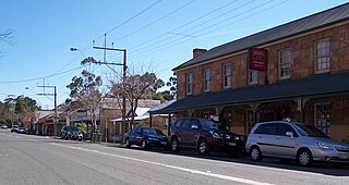
Balhannah is a town in the Adelaide Hills about 30 km southeast of Adelaide, the capital of South Australia. It was established in 1839 as a farming community by James Turnbull Thomson, who built the first hotel. The town soon grew to incorporate two once adjoining towns: Gilleston and Blythetown, named for James Blythe, another Scottish settler.

The City of Onkaparinga is a local government area (LGA) located on the southern fringe of Adelaide, South Australia. It is named after the Onkaparinga River, whose name comes from Ngangkiparinga, a Kaurna word meaning women's river. It is the largest LGA in South Australia, with a population of over 170,000 people in both urban and rural communities and is also geographically expansive, encompassing an area of 518.3 km². The council is headquartered in the Noarlunga Centre with area offices situated in Aberfoyle Park, Woodcroft and Willunga.

Aberfoyle Park is a suburb in the City of Onkaparinga in the state of South Australia. It is located in the southern suburbs of Adelaide, approximately 20 km from the city centre. Aberfoyle Park has a shopping mall called "The Hub", several primary schools and a public high school, one of the biggest in the state.

Lobethal is a town in the Adelaide Hills area of South Australia. It is located in the Adelaide Hills Council local government area, and is nestled on the banks of a creek between the hills and up the sides of the valley. It was once the centre of the Adelaide Hills wool processing industry, which continued until around 1950. The mill buildings are now used by a number of cottage industry and handcraft businesses. At the 2016 census, Lobethal had a population of 2,135.

Old Noarlunga is a suburb in the Australian state of South Australia located about 30 kilometres (19 mi) south of the state capital of Adelaide. Originally settled around 1840, the town retains its village atmosphere in spite of encroaching suburbia.

Port Noarlunga is a suburb in the City of Onkaparinga, South Australia. It is a small sea-side suburb, with a population of 2,918, about 30 kilometres to the south of the Adelaide city centre and was originally created as a sea port. This area is now popular as a holiday destination or for permanent residents wishing to commute to Adelaide or work locally. There is a jetty that connects to a 1.6 kilometres long natural reef that is exposed at low tide. The beach is large and very long and has reasonable surfing in the South Port area whose name is taken from its location - "South of the Port".
Nairne is a small township in the Adelaide Hills of South Australia. Nairne is about 7 kilometres (4 mi) from Mount Barker, South Australia, in the federal Division of Mayo and in the state electoral district of Kavel. At the 2016 census, Nairne had a population of 4,842.

Mount Torrens is a town in the eastern Adelaide Hills region of South Australia, 46 kilometres east-north-east of the state capital, Adelaide and 8 km east of Lobethal. It is located in the Adelaide Hills Council and the Mid Murray Council local government areas. At the 2006 census, Mount Torrens had a population of 337.

Lenswood is a semi-rural village situated in the Adelaide Hills east of Adelaide, South Australia. The major industries are apples, pears, cherries and wine grapes.

Woodside is a town in the Adelaide Hills region of South Australia. The town is between Balhannah and Lobethal, 37 kilometres (23 mi) from the state capital, Adelaide. Mount Barker is also nearby.

Halbury is a former railway town in South Australia, west of the Clare Valley, halfway between Balaklava and Auburn. At the 2006 census, Halbury had a population of 363.
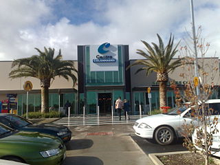
Noarlunga Centre is a suburb in the City of Onkaparinga in the southern suburbs of Adelaide, South Australia. The suburb is mostly commercial, being dominated by the Centro Colonnades shopping centre and the small 'Inspire Noarlunga' estate to the east of Goldsmith Road. The suburb is bordered by Beach Road to the north, Dyson Road to the west Goldsmith Road to the south and the Southern Expressway to the east. Burgess Drive, Seaman Road and David Witton Drive are the main thoroughfares inside the boundaries of the suburb.
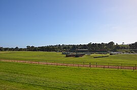
The Oakbank Easter Racing Carnival is a horse-racing meeting held over two days by the Oakbank Racing Club at the Oakbank Racecourse located in the Adelaide Hills in South Australia. The carnival is a mixture of flat and jumping races with between two and four jumps races on day one and two feature jumping races on day two.
Dorset Vale is a rural locality near Adelaide, South Australia. It straddles three local government areas adjacent to the Onkaparinga River, being within the Adelaide Hills, Mount Barker and the Onkaparinga council areas. The precise boundaries were set in April 1994 and extended in November 2003 for the long-established name. The first post office in the area was given the English name Dorset Vale circa 1850, but it was locally known as "Scotts Bottom" as it was downstream from Scott Creek. Scotts Bottom School opened in 1930, its name was changed to Dorset Vale in 1937 and it closed in 1944.

Kangarilla is a small rural town and locality around 33 km (21 mi) from Adelaide city centre, in South Australia. The area, formerly inhabited by Kaurna people, was settled by Europeans in 1840, not long after the British colonisation of South Australia. Today it lies within the City of Onkaparinga local government area, and has postcode 5157. At the 2016 census, Kangarilla had a population of 896.

Charleston is a small town in the Adelaide Hills of South Australia. It is situated on the Onkaparinga Valley Road between Woodside and Mount Torrens, on the main route from the Adelaide Hills to the Barossa Valley, and 3 km south-east of Lobethal. Charleston is very close to the source of the River Onkaparinga.
Lion Brewing and Malting Company of Jerningham Street, Lower North Adelaide was one of the many breweries which proliferated in Australia in the nineteenth-century. In those days beer was much cheaper than now; the wholesale price was 1/ a gallon, but transport was expensive, and small breweries were to be found all over the country. Most of these have now disappeared, having either closed down or become merged in larger businesses. Lion Brewing and Malting eventually confined itself to malting barley and manufacture of aerated waters and cordials.
Oakbank Racing Club, formerly the Onkaparinga Racing Club, is a thoroughbred horse racing organization in South Australia. It is responsible for the Oakbank Racecourse and running the events of the Easter Racing Carnival on that course, culminating in the Great Eastern Steeplechase.