Howard County is one of 92 counties in the U.S. state of Indiana. As of the 2020 census, the population was 83,658. The county seat is Kokomo. Originally named Richardville County, it was renamed in 1844 to commemorate General Tilghman Ashurst Howard.

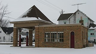
Greentown is a town in Liberty Township, Howard County, Indiana, United States. Located approximately 9 miles east of Kokomo on State Road 22 / US 35; it is home to the Howard County Fair Grounds. The town was platted in 1848, and incorporated as a town in 1873. Known for its collectible glassware made for only a few years by a local factory destroyed in 1903, it is home to the Greentown Glass Museum. As of the 2010 census, the town's population was 2,415.
Center is an unincorporated community in Taylor Township, Howard County, Indiana, United States. Center is a suburb of Kokomo and is a part of the Kokomo, Indiana Metropolitan Statistical Area.
West Middleton is an unincorporated community between Russiaville and Kokomo in western Howard County, Indiana, United States. It is part of the Kokomo, Indiana Metropolitan Statistical Area.
Alto was an unincorporated town which is now a neighborhood of Kokomo in Harrison Township, Howard County, Indiana, United States. It is part of the Kokomo, Indiana Metropolitan Statistical Area. Alto was annexed into the city of Kokomo January 1, 2012.

Cassville is an unincorporated community in Howard Township, Howard County, Indiana, United States. It is part of the Kokomo, Indiana Metropolitan Statistical Area and located approximately 5.9 miles from downtown Kokomo.

Decatur Township is one of the nine townships in Marion County, Indiana, United States, and part of the consolidated city of Indianapolis. As of the 2020 census, it had a population of 36,951. Located in the southwest corner of the county, the township is home to the Indianapolis International Airport main terminal. It is one of the most rural sections of the county, but has seen many new residential and commercial developments. AmeriPlex, one of the largest industrial parks in Indiana, is in Decatur Township. Through the White River, Decatur and Perry townships share the only water boundary among Marion County's townships.

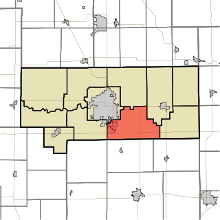
Clay Township is one of eleven townships in Howard County, Indiana, United States. As of the 2020 census, its population was 4,036, up from 3,885 in 2010. This township also contains a small portion of Kokomo. The population of the Kokomo portion, however, is zero.

Harrison Township is one of 11 townships in Howard County, Indiana, United States. As of the 2020 census, its population was 9,848, upfrom 9,489 in 2010.

Howard Township is one of eleven townships in Howard County, Indiana, United States. As of the 2020 census, its population was 2,436, down from 2,579 in 2010.
Liberty Township is one of eleven townships in Howard County, Indiana, United States. As of the 2020 census, its population was 4,737, down from 4,862 in 2010. Liberty Township hosts the Howard County fair each year in July in Greentown, which is the second biggest town in Howard County, and third biggest in the Kokomo Metropolitan Area after only Kokomo, and Tipton.
Taylor Township is one of eleven townships in Howard County, Indiana, United States. As of the 2020 census, its population was 9,396, up from 9,294 in 2010.

Fairfield Township is one of fifteen townships in DeKalb County, Indiana. As of the 2010 census, its population was 1,368 and it contained 691 housing units.

Hemlock is an unincorporated community in southern Taylor Township, Howard County, Indiana, United States. It lies at the intersection of State Road 26 with County Road 450E.
Phlox is an unincorporated community in southern Union Township, Howard County, Indiana, United States. It lies at the intersection of State Road 26 with County Road 1100 East.

Point Isabel is an unincorporated community and census-designated place (CDP) in central Green Township, Grant County, Indiana, United States. It lies at the intersection of State Roads 13 and 26. As of the 2010 census it had a population of 91.

Hackleman is a small unincorporated community in central Liberty Township, Grant County, Indiana.
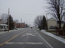
Jerome is an unincorporated community in Union Township, Howard County, Indiana, United States. It is part of the Kokomo, Indiana Metropolitan Statistical Area.

Patricksburg is an unincorporated community in eastern Marion Township, Owen County, in the U.S. state of Indiana. It lies along State Road 246, west of the city of Spencer, the county seat of Owen County. Its elevation is 715 feet (218 m), and it is located at 39°18′56″N86°57′33″W. Although Patricksburg is unincorporated, it has a post office, with the ZIP code of 47455.
Sylvia Clevenger was an American prostitute who worked with madam Pearl Elliott and was a minor associate of the John Dillinger gang. Her brother William was the former husband of Elliott. She was married three times, reverting to her maiden name of Hughes after her divorce from her second husband, John Clevenger, in 1930. She lived for much of her life in Kokomo, Indiana, and died in 1951 in Michigan City, Indiana.