
Tazewell is a town in and the county seat of Claiborne County, Tennessee, United States. The population was 2,165 at the 2000 census, 2,218 at the 2010 census, and 2,348 at the 2020 census. The town is named for Tazewell, Virginia, which itself was named for Henry Tazewell (1753–1799), a U.S. senator from Virginia.
Knoxville is a city in and the county seat of Knox County, Tennessee, United States. As of the 2020 United States census, Knoxville's population was 190,740, making it the largest city in the East Tennessee Grand Division and the state's third-most-populous city after Nashville and Memphis. It is the principal city of the Knoxville metropolitan area, which had a population of 879,773 in 2020.
Farragut is a suburban town located in Knox and Loudon counties in the State of Tennessee, United States. The town's population was 23,506 at the 2020 census. It is included in the Knoxville Metropolitan Area. The town is named in honor of Union Admiral David Farragut, who was born just east of Farragut at Campbell's Station in 1801, and fought in the American Civil War.
Halls Crossroads is a census-designated place in northern Knox County, Tennessee. As a northern suburb of nearby Knoxville, Halls is included in the Knoxville Metropolitan Statistical Area. The town takes its name from the Thomas Hall family that settled in the area in the late 18th century.

Fountain City is a neighborhood in northern Knoxville, Tennessee, in the southeastern United States. Although not a census-designated place, the populations of the two ZIP codes that serve Fountain City— 37918 and 37912— were 36,815 and 18,695, respectively, as of the 2000 U.S. census. At the time of its annexation by the city of Knoxville in 1962, Fountain City was the largest unincorporated community in the United States.

Weigel's is a convenience store chain based in Powell, Tennessee with 68 locations in the East Tennessee region. They also own and operate Broadacre Dairy Inc, which processes milk, tea, juices, and eggnog for their convenience stores, as well as its own bakery, Red Barn Foods.

Sequoyah Hills is a neighborhood in Knoxville, Tennessee, United States, named for the Cherokee scholar Sequoyah. It is located off Kingston Pike, between the city's downtown and West Knoxville. Initially developed in the 1920s, Sequoyah Hills was one of Knoxville's first suburbs and today is home to some of the city's most affluent residents. The neighborhood contains numerous notable examples of mid-20th century residential architecture, with houses designed by architects such as Charles I. Barber, Benjamin McMurry, and Francis Keally.

State Route 331 is a mostly west–east, signed north–south, secondary highway in Knox County in the U.S. state of Tennessee.
This is a list of the National Register of Historic Places listings in Knox County, Tennessee.
WNML is a commercial AM radio station in Knoxville, Tennessee. It is owned by Cumulus Media and it simulcasts a sports radio format with co-owned 99.1 WNML-FM Friendsville. The studios and offices are on Old Kingston Pike in the Sequoyah Hills section of West Knoxville.

Kingston Pike is a highway in Knox County, Tennessee, United States, that connects Downtown Knoxville with West Knoxville, Farragut, and other communities in the western part of the county. The road follows a merged stretch of U.S. Route 11 (US 11) and US 70. From its initial construction in the 1790s until the development of the Interstate Highway System in the 1960s, Kingston Pike was the main traffic artery in western Knox County, and an important section of several cross-country highways. The road is now a major commercial corridor, containing hundreds of stores, restaurants, and other retail establishments.

State Route 131 is a south-to-north highway in the U.S. state of Tennessee that is 68.8 miles long. It is designated as a secondary route.
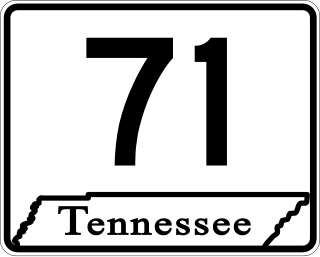
State Route 71 is a north–south state highway in Tennessee. For most of the length it is a "hidden" route, as it coincides with US 441 in all but a short section in Knoxville. The road begins at the North Carolina state line in Sevier County within the Great Smoky Mountains National Park at Newfound Gap and ends at an intersection with US 25W, SR 116, and SR 9 (hidden) in Rocky Top. Along its length SR 71 passes through Sevier County, a small portion of Blount County, Knox County, Anderson County, and in and out of Campbell County. Despite being signed on Hall of Fame Parkway in Knoxville, Tennessee, the Knox County TDOT map ignores SR 71 while SR 33 has a concurrency with US 441.

U.S. Route 441 stretches for 83.28 miles (134.03 km) through the mountains of East Tennessee, connecting Rocky Top with Knoxville, Sevierville, Gatlinburg, and the Great Smoky Mountains National Park, crossing into North Carolina at Newfound Gap. Near its northern terminus, US 441 crosses over Norris Dam and passes through Norris Dam State Park.
North Knoxville is the section of Knoxville, Tennessee, USA, that lies north of the city's downtown area. It is concentrated around Broadway (US-441), Clinton Highway (US-25W), Tazewell Pike (TN-331), Washington Pike, and adjacent roads, and includes the neighborhoods of Fountain City, Inskip-Norwood, Oakwood-Lincoln Park, Old North Knoxville, Fourth and Gill, North Hills, and Whittle Springs. North Knoxville is bisected by Sharp's Ridge, a 7-mile (11 km) elongate ridge that rises prominently above the surrounding terrain.

Bearden, also known as Bearden Village, is a neighborhood in Knoxville, Tennessee, United States, located along Kingston Pike in West Knoxville. Developed primarily as an agrarian community in the 19th century, this neighborhood now lies at the heart of one of Knoxville's major commercial corridors. Named for former Knoxville mayor and Tennessee state legislator, Marcus De Lafayette Bearden (1830–1885), the community was annexed by Knoxville in 1962.
West Hills is a neighborhood in Knoxville, Tennessee, United States, located just off Kingston Pike in West Knoxville. Initially developed in the 1950s, West Hills was Knoxville's first major post-World War II subdivision, and the first subdivision to consist primarily of modern ranch-style houses. While West Knoxville experienced a boom in commercial development in the 1970s and 1980s, West Hills has managed to retain its residential character, due in large part to its aggressive neighborhood advocacy group, the West Hills Community Association.

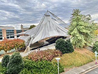
The University of Tennessee, Knoxville, is a public land-grant research university in Knoxville, Tennessee, United States. Founded in 1794, two years before Tennessee became the 16th state, it is the flagship campus of the University of Tennessee system, with ten undergraduate colleges and eleven graduate colleges. It hosts more than 30,000 students from all 50 states and more than 100 foreign countries. It is classified among "R1: Doctoral Universities – Very high research activity".

Harbison Crossroads is an unincorporated community of Knox County, Tennessee, United States, located approximately 10 miles Northeast of Knoxville. It is also referred by the unofficial name of Gibbs.

State Route 33 is a primary and secondary route in East Tennessee. It runs 176 miles, from the Georgia state line in Polk County, northeast to the Virginia state line north of Kyles Ford in Hancock County. South of Maryville, SR 33 is a "hidden" route which shares a concurrency with US 411.