
Clinton County is a county located in the U.S. state of Missouri and is part of the Kansas City metropolitan area. As of the 2020 U.S. Census, the county had a population of 21,184. Its county seat is Plattsburg. The county was organized January 2, 1833 and named for Governor DeWitt Clinton of New York. The county seat of Plattsburg derives its name from a town of a similar name that is the county seat of Clinton County, New York, which was also named for the Governor.

Clay County is located in the U.S. state of Missouri and is part of the Kansas City metropolitan area. As of the 2020 census, the county had a population of 253,335, making it the fifth-most populous county in Missouri. Its county seat is Liberty. The county was organized January 2, 1822, and named in honor of U.S. Representative Henry Clay from Kentucky, later a member of the United States Senate and United States Secretary of State.

Montgomery County is located in the southwestern portion of the U.S. state of Ohio. As of the 2020 census, the population was 537,309, making it the fifth-most populous county in Ohio. The county seat is Dayton. The county was named in honor of Richard Montgomery, an American Revolutionary War general killed in 1775 while attempting to capture Quebec City, Canada. Montgomery County is part of the Dayton, Ohio Metropolitan Statistical Area.
Dickenson County is a county located in the Commonwealth of Virginia. As of the 2020 census, the population was 14,124. Its county seat is Clintwood.

Buchanan County is a United States county in far western Virginia, the only county in the state to border both West Virginia and Kentucky. The county is part of the Southwest Virginia region and lies in the rugged Appalachian Plateau portion of the Appalachian Mountains. Its county seat is Grundy.

Buchanan County is located in the U.S. state of Missouri. As of the 2020 United States Census, the population was 84,793. Its county seat is St. Joseph. When originally formed in 1838, the county was named Roberts County, after settler Hiram Roberts. It was renamed in 1839 for James Buchanan, then a U.S. Senator and later President of the United States. The county was formed from land annexed to Missouri, as were five other counties.

Buchanan is a town in Botetourt County, Virginia, United States. The population was 1,196 at the 2020 census. It is part of the Roanoke Metropolitan Statistical Area. It was the western terminus of the James River and Kanawha Canal when construction on the canal ended.
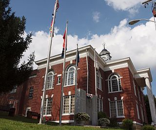
Grundy is a town in Buchanan County, Virginia, United States, an area located within the Appalachian Mountains region. It is the county seat of Buchanan County. The town is home to the Appalachian School of Law. The population was 875 as of the 2020 census.

The James River is a river in Virginia that begins in the Appalachian Mountains and flows 348 miles (560 km) to the Chesapeake Bay. The river length extends to 444 miles (715 km) if the Jackson River is included, the longer of its two headwaters. It is the longest river in Virginia. Jamestown and Williamsburg, Virginia's first colonial capitals, and Richmond, Virginia's current capital, lie on the James River.

U.S. Route 119 (US 119) is a spur of US 19. It is a north–south route that was an original United States highway of 1926. It is Corridor G of the Appalachian Development Highway System (ADHS) east of US 23 and KY 80 in Kentucky to Interstate 64 at Charleston, West Virginia.

Valley Pike or Valley Turnpike is the traditional name given for the Indian trail and roadway which now approximates as U.S. Route 11 in the Shenandoah Valley of Virginia.

U.S. Route 460 (US 460) in Virginia runs west-east through the southern part of the Commonwealth. The road has two separate pieces in Virginia, joined by a relatively short section in West Virginia. Most of US 460 is a four-lane divided highway and is a major artery in the southern third of the state. From Petersburg to Suffolk, US 460 is a four-lane non-divided highway. It is a popular alternative to Interstate 64 (I-64) when going from Richmond and other points in central Virginia to the Currituck Sound and Outer Banks of North Carolina, avoiding the congestion and tunnels of the more northerly I-64 corridor. The road passes through several small towns that built up at stops along the railroad line.

State Route 83 is a primary state highway in the U.S. state of Virginia. The state highway runs 61.71 miles (99.31 km) from U.S. Route 23 Business in Pound east to the West Virginia state line in Paynesville, where the highway continues as West Virginia Route 83. SR 83 is the main highway of Dickenson County, where it connects the county's three towns of Clintwood, Clinchco, and Haysi. The state highway connects those towns with Pound in Wise County and Grundy in Buchanan County, and connects Grundy with McDowell County, West Virginia.
Prater is an unincorporated community located in Buchanan County, Virginia. It is near the intersection of Virginia State Route 83 and County Route 604 in the western portion of the county. The community is the home of Russell Prater Elementary School.

Big Rock is an unincorporated community and census-designated place (CDP)in Buchanan County, Virginia located at the convergence of County Route 650 and U.S. Route 460, a short distance from the Kentucky state line. It was first listed as a CDP in the 2020 census with a population of 199.
Keen Mountain is an unincorporated community in Buchanan County, Virginia located on U.S. Route 460, just south of the community of Oakwood, Virginia.
Deel is an unincorporated community in Buchanan County, Virginia, United States. Deel is located on U.S. Route 460 3 miles (4.8 km) south-southeast of Grundy.
Peapatch is an unincorporated community in Buchanan County, Virginia and McDowell County, West Virginia, United States, straddling the Virginia–West Virginia border.
Rowe is an unincorporated community in Buchanan County, Virginia, United States. Rowe is located on State Route 624 6 miles south of Oakwood. Rowe has a post office with ZIP code 24646, which opened on January 25, 1939.
Bearwallow is an unincorporated community in Buchanan County, Virginia, United States. Bearwallow is located in the extreme northeastern corner of the county on Virginia State Route 616, approximately 19.8 miles (31.9 km) east-southeast of Grundy. A short distance to the east of Bearwallow lies the intersection of Buchanan County with Tazewell County, Virginia and McDowell County, West Virginia.


