Oaxtepec

Last updated

Oaxtepec is a town within the municipality of Yautepec and the Cuautla metropolitan area in the eastern part of the Mexican state of Morelos. Its main industry is tourism, mostly aimed at the inhabitants of nearby Mexico City, and the town possesses various aquatic resorts and hotels. The climate is tropical and the countryside very lush.

Contents

The population of Oaxtepec is 7,097 (2020). [1] Oaxtepec had 6,939 inhabitants in 2010. [2] During the XIX Olympiad in 1968, Oaxtepec was the venue and staging area for the World Youth Camp component of the Cultural Olympiad.[ citation needed ] Equestrian events at the 1968 Olympiad were held in Oaxtepec. [3]

History

In pre-Columbian times, already one of the largest towns in the region, it was conquered by the Aztecs under the rule of Moctezuma Ilhuicamina. [4] During Moctezuma Ilhuicamina's reign (1440–1469), the first leisure center for nobles was created in the warm territory of Oaxtepec, as well as low lands to the south of Tenochtitlan valley, today's Morelos. Moctezuma ordered to use the water springs of Oaxtepec to create an irrigation system for agriculture and preservation of important vegetation of the Aztec empire. An elaborate royal garden was established here where both flowers and other plants were cultivated. This was the first botanical garden in the Americas. [5]

When the Spanish first arrived in the region, they marveled at the beauty of the place. They praised Oaxtepec in their chronicles of the Aztec conquest. [6] :338

In the 16th century, thanks to the great number of medicinal plants found in the region, the Spaniards decided to build the Santa Cruz de Oaxtepec hospital. Bernandino Álvares directed the project in 1569 and for the next two hundred years it was administrated by the Hermanos de la Caridad (Brother of Charity). The Templo de Santo Domingo de Guzmán (Church of Saint Dominic of Guzman) was built on the ruins of the main pyramid of Oaxtepec.

A major event occurred in 1964 when the Centro Vacacional Adolfo López Mateos IMSS Oaxtepec (waterpark run by Mexican Social Security Institute) was built on 120 hectares of land. This was the most important water park in Latin America. In 2018 it was remodeled, sold to a private company, and renamed Six Flags Hurricane Harbor. A smaller water park called Parque Acuatico Oaxtepec (PAO) used to be in the area, but it was purchased by Hurricane Harbor. [7]

Name and location

The etymology of Oaxtepec is from the Nahuatl language and it means "On the mountain of huajes". Huaje is the Mexican Spanish name for the leadtree, Leucaena esculenta , whose fruits are edible and is a popular food in south-central Mexico. [8]

Oaxtepec is located at an altitude of 1,377 metres (4,518 ft) above sea level.

Places of interest

Monastery of Santo Domingo

Facade of the Ex Convent of Santo Domingo de Guzman, Oaxtepec, Morelos. Ex Convento de Santo Domingo de Guzman Oaxtepec - Portada.JPG
Facade of the Ex Convent of Santo Domingo de Guzmán, Oaxtepec, Morelos.

The Ex-convento of Santo Domingo Félix de Guzmán was built by the Dominican Order between 1528 and 1580. The church was actually called Santiago Apóstol. It consists of an atrium opening onto the town's main plaza, a single nave, and two small chapels. There are two towers on the side. [9]

During the Siege of Cuautla (1812), the church served as headquarters for General Leonardo Bravo. It also served as a headquarters for the Liberation Army of the South during the Mexican Revolution. Later it was a high school incorporated with the Autonomous University of the State of Morelos, (UAEM) and as the local House of Culture. A few years ago it was returned to the Church. [9]

Water Parks

Six Flags Hurricane Harbor is a chain of water parks headquartered in Grand Prairie, Texas. Features include a variety of body slides, speed slides, tube slides, wave pools, lazy rivers, and shopping areas. The Oaxtepec water park opened in 2017 and is one of the largest in Latin America. [10] The water park opened as Centro Vacacional "Adolfo López Mateos" IMSS Oaxtepec on 120 hectares (300 acres) of land run by the Mexican Social Security Institute in 1964. In 1998, it was sold to a private company and reopened as "Parque Acuático Oaxtepec (PAO)"; the company went into bankruptcy in 2011, after which it was sold to Six Flags. [10] The Social Security Institute runs hotels and campgrounds within the park. [11]

Balneario El Bosque Oaxtepec ("The Oaxtepec forest water park″) is a rustic water park with a suspension bridge, waterfalls, river, pools, and archeological zone. [12] The Pozo Azul (Blue Pond) is believed to have been used by Tlatoani Moctezuma I in the 15th century. [13]

Archeology

In addition to the archeological site within the water park named above, prehispanic ruins can be found on the Cerro de los Huajes ("Hill of leadtrees") near the cemetery. Ruins of the colonial (1586-1820) Hospital de la Santa Cruz, built by the Brothers of Charity (Spanish: Hospitalarios) are near "El Bosque" water park.

Climate

Climate data for Oaxtepec
MonthJanFebMarAprMayJunJulAugSepOctNovDecYear
Mean daily maximum °C (°F)27.1
(80.8)
28.6
(83.5)
30.7
(87.3)
32
(90)
32.1
(89.8)
29.6
(85.3)
28.5
(83.3)
28.3
(82.9)
27.6
(81.7)
27.9
(82.2)
27.7
(81.9)
27
(81)
29.0
(84.2)
Mean daily minimum °C (°F)12.4
(54.3)
13.4
(56.1)
15.3
(59.5)
17.1
(62.8)
18
(64)
17.4
(63.3)
16.3
(61.3)
16.3
(61.3)
16.3
(61.3)
15.3
(59.5)
13.6
(56.5)
12.6
(54.7)
15.3
(59.5)
Average precipitation mm (inches)10
(0.4)
5.1
(0.2)
5.1
(0.2)
13
(0.5)
53
(2.1)
200
(8)
170
(6.7)
200
(7.9)
200
(7.9)
76
(3)
15
(0.6)
5.1
(0.2)
960
(37.7)
Source: Weatherbase [14]

See also

Related Research Articles

<span class="mw-page-title-main">Moctezuma I</span> Fifth Tlatoani of Tenochtitlan

Moctezuma I, also known as Moteuczomatzin Ilhuicamina, Huehuemoteuczoma or Montezuma I, was the second Aztec emperor and fifth king of Tenochtitlan. During his reign, the Aztec Empire was consolidated, major expansion was undertaken, and Tenochtitlan started becoming the dominant partner of the Aztec Triple Alliance. Often mistaken for his popular descendant, Moctezuma II, Moctezuma I greatly contributed to the famed Aztec Empire that thrived until Spanish arrival, and he ruled over a period of peace from 1440 to 1453. Moctezuma brought social, economical, and political reform to strengthen Aztec rule, and Tenochtitlan benefited from relations with other cities.

<span class="mw-page-title-main">Morelos</span> State of Mexico

Morelos, officially the Free and Sovereign State of Morelos, is a landlocked state located in south-central Mexico. It is one of the 32 states which comprise the Federal Entities of Mexico. It is divided into 36 municipalities and its capital city is Cuernavaca.

<span class="mw-page-title-main">Cuautitlán Izcalli</span> City & Municipality in State of Mexico, Mexico

Cuautitlán Izcalli is a city and one of the 125 municipalities that make up the State of Mexico. Its municipal seat is Cuautitlán Izcalli. It is located in the Valley of Mexico area, and is part of the Metropolitan area of Mexico City. It borders to the north and northwest with Tepotzotlán, to the northeast and to the east with Cuautitlán, to the south with Tlalnepantla de Baz, to the southeast with Tultitlán, to the southwest with Atizapán de Zaragoza and to the west with the municipality of Nicolás Romero.

<span class="mw-page-title-main">Atlatlahucan</span> Town in Morelos, Mexico

Atlatlahucan is a city in the Mexican state of Morelos. The name means Place of red or brown water, and today the water is stored in a type of cistern called a jagüey. To the north is the State of Mexico, south is Cuautla, east is Yecapixtla, and west are Tlayacapan and Yautepec. It stands at 18°56′N98°54′W, at a mean height of 1,656 metres above sea level. The municipality covers 71 km2.

Ciudad Ayala is a city in the east-central part of the Mexican state of Morelos. It is named for Coronel Francisco Ayala who fought with José María Morelos during the 1812 Siege of Cuautla. The town's previous name was Mapachtlan. Ayala became a municipality on April 17, 1869.

<span class="mw-page-title-main">Cuautla, Morelos</span> Municipal and rural in Morelos, Mexico

Cuautla, officially La heroica e histórica Cuautla, Morelos or H. H. Cuautla, Morelos, is a city and municipality in the Mexican state of Morelos, about 104 kilometers south of Mexico City. In the 2010 census the city population was 154,358. The municipality covers 153.651 km2 (59.325 sq mi). Cuautla is the third most populous city in the state, after Cuernavaca and Jiutepec. The city was founded on April 4, 1829. The 2020 population figures were 187,118 inhabitants for the municipality and 157,336 inhabitants for the city of Cuatula.

Jonacatepec de Leondro Valle is a city in the Mexican state of Morelos. The city serves as the municipal seat for the surrounding municipality of the same name. The municipality reported 15,690 inhabitants in the year 2015 census.

<span class="mw-page-title-main">Tepoztlán</span> City in Morelos, Mexico

Tepoztlán is a town in the central Mexican state of Morelos. It is located at 18°59′07″N99°05′59″W in the heart of the Tepoztlán Valley. The town serves as the seat of government for the municipality of the same name. The town had a population of 14,130 inhabitants, while the municipality reported 41,629 inhabitants in the 2010 national census.

<span class="mw-page-title-main">Tetela del Volcán</span>

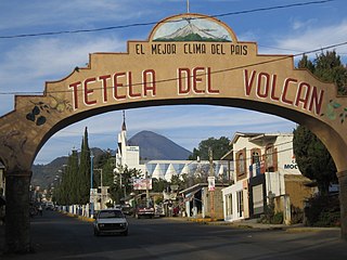
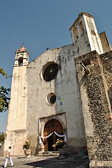
Tetela del Volcán or simply Tetela, is a town and municipal seat of the municipality of Tetela del Volcán in the Mexican state of Morelos. It is located on the slopes of the volcano Popocatépetl. 18°57′48″N99°15′12″W. The city serves as the municipal seat for the surrounding municipality of the same name. It is notable for its sixteenth century Dominican ex-convent which together with a number of other early monasteries nearby in the area has been declared a UNESCO World Heritage Site. The municipality reported 20,698 inhabitants in the year 2015 census. Other towns in the municipality of Tetela del Volcán include Hueyapan, Xochicalco and Tlamimilulpan.

Tlaltizapán de Zapata is a city in the Mexican state of Morelos. It stands at 18°4′N99°07′W.

<span class="mw-page-title-main">Tlaquiltenango</span> Mexican city

Tlaquiltenango is a city in the Mexican state of Morelos. It is 151.6 kilometres (94.2 mi) south of Mexico city and 60.1 kilometres (37.3 mi) southeast of Cuernavaca, the state capital via Mexican Federal Highway 95D.

Totolapan is a municipality in the north of the Mexican state of Morelos, surrounded by the State of Mexico to the north; to the south with Tlayacapan and Atlatlahucan; to the east and southeast with Atlatlahucan; and to the west with Tlalnepantla.

<span class="mw-page-title-main">Yautepec, Morelos</span> Municipality in Morelos, Mexico

Yautepec is a municipality located in the north-central part of the Mexican state of Morelos. The municipal seat is the city of Yautepec de Zaragoza. It stands at 18°53′N99°04′W.

Zacualpan de Amilpas is a town in the Mexican state of Morelos. The town serves as the municipal seat for the surrounding municipality, with which it shares a name. To the north is the municipality of Tetela del Volcán, to the south is the municipality of Temoac, to the east is the State of Puebla, and to the west are the municipalities of Ocuituco and Yecapixtla.

<span class="mw-page-title-main">Hueyapan, Morelos</span> Town in Morelos, Mexico

San Andrés Hueyapan is a small town in the rural northeastern part of the Mexican state of Morelos, formerly in the municipality of Tetela del Volcán. It lies at an elevation of ca 2000–2500 metres above sea level on the southern slopes of the active volcano Popocatépetl. To the west of Hueyapan runs the Amatzinac river, to the north is the Popocatépetl-Iztaccíhuatl natural reserve, and to the south the town of Tlacotepec and to the east is the municipality of Tochimilco which belongs to the state of Puebla located in the midlands.

<span class="mw-page-title-main">Monasteries on the slopes of Popocatépetl</span> Historic site in Areas south and east of Popocatépetl, Mexico

The Earliest Monasteries on the Slopes of Popocatepetl are sixteen earliest 16th-century monasteries which were built by the Augustinians, the Franciscans and the Dominicans in order to evangelize the areas south and east of the Popocatépetl volcano in central Mexico. These monasteries were recognized by the UNESCO as World Heritage Sites in 1994, because they served as the model for the early monastery and church buildings as well as evangelization efforts in New Spain and some points beyond in Latin America. These monasteries almost uniformly feature a very large atrium in front of a single nave church with a capilla abierta or open chapel. The atrium functioned as the meeting point between the indigenous peoples and the missionary friars, with mass for the newly converted held outdoors instead of within the church. This arrangement can be found repeated in other areas of Mexico as these friars continued to branch out over New Spain.

Las Estacas Natural Reserve and Spa is a mineral spring, day spa and natural reserve located in the town of Tlaltizapan, in the state of Morelos, Mexico. The natural reserve is a protected area for plants and wildlife since 1998; the protected area has 652.17 hectares and harbors a first magnitude spring with a flow rate of 6,700 L/s.

The 1981–82 Segunda División was the 33rd season of the Mexican Segunda División. The season started on 15 August 1981 and concluded on 24 July 1982. It was won by Oaxtepec.

References

  1. "¿Cuántos habitantes tiene... - Censo de Población y Vivienda 2020". inegi.org.mx. INEGI. Retrieved February 23, 2021.
  2. "Oaxtepec (Yautepec, Morelos, Mexico) - Population Statistics, Charts, Map, Location, Weather and Web Information". www.citypopulation.de. Retrieved May 11, 2020.
  3. "The Olpympics: Friends in High Places". Time. 30 December 1966. Retrieved May 11, 2020.
  4. Hassig, 1988 p. 161
  5. "Historia de Oaxtepec" (in Spanish). Archived from the original on 2020-09-27.
  6. Diaz, B., 1963, The Conquest of New Spain, London: Penguin Books, ISBN   0140441239
  7. "Parque Acuatico Oaxtepec" (in Spanish). Archived from the original on 2020-10-23.
  8. "Leucaena esculenta - Useful Tropical Plants". tropical.theferns.info. Retrieved May 11, 2020.
  9. 1 2 Guzmán, Alianzas y Negocios :: Iglesia y Ex-Convento de Santo Domingo de. "Alianzas y Negocios :: Iglesia y Ex-Convento de Santo Domingo de Guzmán". alianzasynegocios.mx (in Spanish). Retrieved May 9, 2020.
  10. 1 2 "Hurricane Harbor Oaxtepec". Six Flags Hurricane Harbor (in Spanish). Retrieved May 9, 2020.
  11. "oaxtepec_informacion". centrosvacacionales.imss.gob.mx. Retrieved May 9, 2020.
  12. "El Bosque Oaxtepec ubicado en el bello Estado de Morelos". El Bosque Oaxtepec (in Spanish). Retrieved May 9, 2020.
  13. "El Bosque". www.balnearioejidalelbosque.com.mx. Retrieved May 9, 2020.
  14. "Weatherbase: Historical Weather for Oaxtepec, Morelos". Weatherbase. 2011. Retrieved on November 24, 2011.

Literature

18°54′N98°58′W / 18.900°N 98.967°W / 18.900; -98.967