
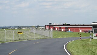
Akron–Canton Airport is a commercial airport in the city of Green, in southern Summit County, Ohio. The airport is located about 14 miles (23 km) southeast of Akron and 10 miles (16 km) northwest of Canton. It is jointly operated by Summit County and Stark County. The airport is a "reliever" airport for Northeast Ohio and markets itself as "A better way to go", emphasizing the ease of travel in comparison to Cleveland Hopkins International Airport. Just under 90% of its traffic is general aviation. It is included in the Federal Aviation Administration (FAA) National Plan of Integrated Airport Systems for 2019–2023, in which it is categorized as a small-hub primary commercial service facility.

Presque Isle International Airport, formally Northern Maine Regional Airport at Presque Isle, is a mile northwest of Presque Isle, in Aroostook County, Maine, United States. It serves the residents of Presque Isle and a vast area of northern Maine and northwestern New Brunswick. Airline flights to Newark Liberty International Airport are subsidized by the federal government's Essential Air Service program at a cost of $3,892,174.

Fort Worth Meacham International Airport is a general aviation airport located near the intersection of Interstate 820 and Business U.S. Highway 287 in Fort Worth, Texas, United States. It is named after former Fort Worth Mayor Henry C. Meacham. The airport covers 745 acres.

Chicago Executive Airport, formerly Palwaukee Municipal Airport, is a public airport 18 miles (33 km) northwest of Chicago, in the village of Wheeling in Cook County, Illinois, United States. It is owned by the City of Prospect Heights and the Village of Wheeling.

Ann Arbor Municipal Airport is a general aviation airport in Washtenaw County, Michigan, United States. It is included in the Federal Aviation Administration (FAA) National Plan of Integrated Airport Systems for 2017 to 2021, in which it is categorized as a regional general aviation facility.

Addison Airport is a public airport in Addison, in Dallas County, Texas, United States, 9 mi north of downtown Dallas. It opened in 1954 and was purchased by the town of Addison in 1976. It is home to the Cavanaugh Flight Museum.

Sherman Municipal Airport is a city-owned public airport located 1 mile (1.6 km) mile southeast of the central business district of Sherman, in Grayson County, Texas.
Mansfield Municipal Airport is a public airport located 2 mi southeast of the central business district of Mansfield, a town in Bristol County, Massachusetts, United States. During World War II, the airfield was Naval Outlying Landing Field Mansfield.

Montgomery-Gibbs Executive Airport, formerly known as Montgomery Field and Gibbs Field, is a public airport in San Diego, California, United States, six miles (10 km) north of downtown San Diego. The airport covers 456 acres (185 ha) and has three runways, one public and two private helipads. The runways are 28 Right/10 Left-28 Left/10 Right parallels and 05/23.
Air Park-Dallas Airport is a public airport located 16 nautical miles (30 km) northwest of the central business district of Dallas, in Collin County, Texas, United States. The airport is used solely for general aviation purposes. It was built as an airpark-style development, with adjacent homeowners having perpetual runway access guaranteed by restrictive covenants, but no formal ownership or management interest in the physical airfield facilities. The airport was formerly within the city limits of Hebron, Texas but was annexed by the city of Carrollton in 2008; the nearby residential lots were not included in the annexation.

Mineral Wells Airport is a public airport four miles southeast of Mineral Wells, Texas. The National Plan of Integrated Airport Systems for 2011–2015 called it a general aviation facility. It is owned and operated by the city of Mineral Wells. The airport, and the city, lie in Palo Pinto County and Parker County. The terminal is in Parker County.
Mesquite Metro Airport is a public use airport in Dallas County, Texas, 3 nautical miles (5.6 km) east of the central business district of Mesquite. The airport is west of the border of Dallas County and Kaufman County.
Clermont County Airport is a public use airport located two nautical miles west of the central business district of Batavia, a village in Clermont County, Ohio, United States. It is owned by the Clermont County Commissioners.
Northwest Regional Airport is a privately owned, public use airport 3 nautical miles (5.6 km) northwest of Roanoke, in Denton County, Texas, United States.

TWA Flight 427 was a regularly scheduled TWA passenger flight departing St. Louis Lambert International Airport (STL) in Bridgeton, Missouri on November 22, 1994, operated using a McDonnell Douglas MD-82. On the takeoff roll it struck a Cessna 441 Conquest II, killing both of its occupants.

Custer Airport, sometimes referred to as Monroe Custer Airport, is a city-owned public airport located in the city of Monroe in Monroe County, Michigan. The airport opened in November 1946 and was named for George Armstrong Custer, who spent much of his early life in Monroe. It is included in the Federal Aviation Administration (FAA) National Plan of Integrated Airport Systems for 2017–2021, in which it is categorized as a local general aviation facility.
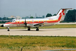
On April 9, 1990, Atlantic Southeast Airlines Flight 2254, a scheduled passenger flight from Muscle Shoals, Alabama, to Gadsden, Alabama, to Atlanta, Georgia, was involved in a mid-air collision with a Cessna 172 over Gadsden. The collision resulted in the death of the pilot and passenger of the Cessna 172.
Caddo Mills Municipal Airport is a city-owned public airport 2 nautical miles (3.7 km) southwest of the central business district of Caddo Mills, Texas, United States. The airport has no IATA or ICAO designation.
Parker County Airport is a privately owned public airport in Hudson Oaks, Parker County, Texas, United States. The airport serves the city of Weatherford, and is located approximately 5 nautical miles (9.3 km) east of the central business district.
