
Bridgend is a town in Bridgend County Borough in Wales, 20 miles (32 km) west of the capital Cardiff and 20 miles (32 km) east of Swansea. The river crossed by the original bridge, which gave the town its name, is the River Ogmore, but the River Ewenny also passes to the south of the town.

Bridgend is a county borough in southern Wales, UK. The county borough has a total population of 139,200 people, and contains the town of Bridgend, after which it is named. Its members of the Senedd are Carwyn Jones MS, the former First Minister of Wales and Huw Irranca-Davies MS representing the Ogmore Constituency, and its members of UK parliament are Jamie Wallis and Chris Elmore.

The River Ogmore is a river in South Wales that is popular with anglers. It runs generally from north to south from the Ogmore Vale and Gilfach Goch, past Bridgend and Ogmore. The River Ogmore rises at Craig Ogwr in the Ogmore Valley as the Ogwr Fawr before it links with the Ogwr Fach at Blackmill. The River Llynfi, the River Garw and finally the River Ewenny in its estuary are all tributaries of the Ogmore which flows into the sea between Ogmore-by-Sea and the Merthyr Mawr sand-dunes.

The Borough of Ogwr was one of six districts of Mid Glamorgan in Wales, which existed from 1974 to 1996.
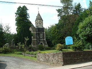
Tondu is a village in Bridgend County Borough, Wales, located about 3 miles (4.8 km) north of the town of Bridgend, in the community of Ynysawdre.
The Garw Valley Railway is the trading name of the Bridgend Valleys Railway Company Limited. It operates a short section of 4 ft 8+1⁄2 instandard gauge railway located in South Wales, which is being recreated as a heritage railway. Formerly part of the Llynvi and Ogmore Railway (L&OR) and built by the Great Western Railway (GWR), the line was used for freight and passenger services, with most of the track still in place between Brynmenyn and Pontycymer. The project currently has a train shed at Pontycymer, and hopes to initially offer brake van rides between Pontycymer and Pant-y-Gog, a distance of 0.5 miles (0.8 km).
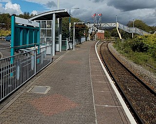
Tondu railway station is a railway station serving the village of Tondu, Bridgend county borough, South Wales. It is located on the Maesteg Line from Cardiff via Bridgend.

Aberkenfig is a village located in the County Borough of Bridgend, Wales to the north of Bridgend town. The community population is shown under Newcastle Higher.

St. Brides Major is a village within the community also called St Brides Major in the Vale of Glamorgan in Wales.
In 1861 the Llynvi Valley Railway was opened in Glamorganshire, Wales, to convey mineral products to the Bristol Channel at Porthcawl. It adopted an earlier tramroad, the Duffryn Llynvi and Porthcawl Railway. The Llynvi and Ogmore Railway was opened in 1865, and the two companies amalgamated to form the Llynvi and Ogmore Railway in 1866. At first Porthcawl harbour was an important destination for onward transport, but this soon declined.
Sarn is a village in Bridgend County Borough, Wales, about 3 miles north of Bridgend and which lies just east of the confluence of the Ogmore and Llynfi rivers. It is located to the east of Aberkenfig, south of Brynmenyn, and south-east of Tondu. It is around 15 minutes' walk from the M4 and the McArthurGlen Group Bridgend Designer Outlet.
Bryncethin is a small village and electoral ward in the County Borough of Bridgend, South Wales, located just north of Junction 36 of the M4 Motorway and approximately 3 miles north of the county town of Bridgend. The population of the ward was 1,319 in 2011.
Gilfach Goch is a community, electoral ward and small former coal mining village in the Borough of Rhondda Cynon Taf, south Wales, near the larger community of Tonyrefail. It is situated in the Cwm Ogwr Fach between the Cwm Ogwr Fawr to the west and the Cwm Rhondda to the east.
John Brogden and Sons was a firm of Railway Contractors, Iron and Coal Miners and Iron Smelters operating, initially as a general contractor, from roughly 1828 until its bankruptcy in 1880.
Nant-y-moel or Nantymoel[nant ə mɔi̯l] is a village and includes the formerly separate village of Pricetown in the county borough of Bridgend, Wales on the River Ogmore, and is one of the constituent villages of the Ogmore Valley. It is bordered by the village of Wyndham to the south and by the Bwlch y Clawdd mountain to the north.

Ynysawdre is a small community in Bridgend County Borough, south Wales. It is located to the east of Aberkenfig in Wales, and comprises the two villages of Tondu and Brynmenyn. The name Ynysawdre is also usually used for a small section of Tondu. At the 2001 census, the population of the community was 3,698, reducing to 3,367 at the 2011 Census.

Ogmore Valley is a community in the Bridgend County Borough, Mid Glamorgan, Wales. Made up of the villages of Nantymoel, Ogmore Vale, Price Town and Wyndham, its population at the time of the 2001 census was 7,800, increasing to 7,954 at the 2011 Census. The ribbon housing of the valley follows the Ogwr Fawr tributary which rises at Craig Ogwr and joins the Ogwr Fach at Blackmill. Villages include Nantymoel, Price Town, Wyndham, Ogmore Vale, Lewistown, Pant-yr-awel and Blackmill.

Wyndham is a small village in the County Borough of Bridgend, Wales built alongside the Ogwr Fawr tributary of the River Ogmore. The village is part of the community of the Ogmore Valley and is south of Nantymoel and north west of Ogmore Vale. The village grew out of the industrialisation of the valley in the 19th century, when coal mines were sunk in the area. The village is also nearby the local industrial estate Penllwyngwent in Ogmore Vale. Wyndham also has a convenience store called "Patel's Minimarket" which is a small minimarket near the main road. Opposite the convenience store is a youth club called the "Wyndham Boys and Girls Club" which has been open for nearly 80 years. At the end of Wyndham, there is a pub called the "Wyndham Arms". Nearby, between Wyndham and Ogmore Vale, there is a Primary School called Ogmore Vale Primary School. In Wyndham, there is a Christian Church which is called St David's Church owned by Father Julien. Wyndham has access to a cycle track. Wyndham has panoramic views of the Bwlch. It has easy access the A4061. The party Labour has held Wyndham for many years and is now led by the leader Huw Irranca-Davies.
Price Town is situated 9 miles north of the County Town of Bridgend on the A4061 road in the upper reaches of the Cwm Ogwr Fawr, Wales. It was developed to provide accommodation for the rapidly increasing work force of the Wyndham and Ocean Western Collieries. Today Price Town is regarded as part of the village Nantymoel.


