Yola, meaning 'Great Plain' or 'Vast Plain Land', is a large city, capital city and administrative centre of Adamawa State, Nigeria. It is located on the Benue River, and it has a population of over 336,648 (2010). Yola is split into two parts. The old town of Yola where the Lamido resides is the traditional city and the new city of Jimeta is the administrative and commercial centre. They are generally referred to as Yola.
Abak is a town and Local Government Area in Akwa Ibom State, Nigeria. The LGA was previously part of Cross River State. It was later sub divided into other local government areas such as Oruk Anam, Etim Ekpo, Ukanafun and Ika. Notable tribes include the Annang. Abak consists of five clans: Abak Urban, Afaha obong, Ediene, Midim and Otoro. The major economic activities of the people of this area before and after the Nigerian Civil War was palm produce exported through river port at Ekpene Okpo, Ntak Ibesit, a distance of about 8 km from Abak town. Abak town, the local government headquarters is located about 18 kilometres from Uyo, the State capital. It has a landmass of 304 square kilometers. Abak to say the least, is the shadow of its former self due to politically motivated neglect by successive governments in Akwa Ibom state. Abak was the economic hub of the former Southeastern Nigeria before the civil war. The Nigerian Army barrack that is popularly known as Ibagwa Barrack is located or can be found in the Abak. The Ime Umana Campus of the university of Uyo which accommodates the Pre-Degree, JUPEB and other special courses is located in Ediene Abak, Abak

Cross River State is a state in the South-South geopolitical zone of Nigeria. Named for the Cross River, the state was formed from the eastern part of the Eastern Region on 27 May 1967. Its capital is Calabar, it borders to the north through Benue state, to the west through Ebonyi state and Abia state, and to the southwest through Akwa Ibom state, while its eastern border forms part of the national border with Cameroon. Originally known as the South-Eastern State before being renamed in 1976, Cross River state formerly included the area that is now Akwa Ibom state, which became a distinct state in 1987.
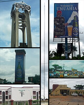
Umuahia is the capital city of Abia State in southeastern Nigeria. Umuahia is located along the rail road that lies between Port Harcourt to its south,and Enugu city to its north. Umuahia has a population of 359,230 according to the 2006 Nigerian census. Umuahia is indigenously Igbo.

Benue State is one of the North Central states in Nigeria with a population of about 4,253,641 in the 2006 census. The state was created in 1976 and was among the seven states created at that time. The state derives its name from the Benue River which is the second largest river in Nigeria after the River Niger. The state borders Nasarawa State to the North; Taraba State to the East; Kogi State to the West; Enugu State to the South-West; Ebonyi and Cross-Rivers State to the South; and has an international border with Cameroon to the South-East. It is inhabited predominantly by the Tiv, Idoma, and Igede people. Minority ethnic groups in Benue are Etulo, Igbo, and Jukun people, etc. Its capital is Makurdi. Benue is a rich agricultural region; common crops include oranges, mangoes, sweet potatoes, cassava, soya bean, guinea corn, flax, yams, sesame, rice, groundnuts, and palm trees.

Ebonyi State is a state in the South-East geopolitical zone of Nigeria, bordered to the north and northeast by Benue State, Enugu State to the west, Cross River State to the east and southeast, and Abia State to the southwest. Named for the Abonyi (Aboine) River—a large part of which is in the state's south—Ebonyi State was formed from parts of Abia and Enugu state in 1996 and has its capital in Abakaliki.

Nasarawa State is a state in the North Central region of Nigeria, bordered to the east by the states of Taraba and Plateau, to the north by Kaduna State, to the south by the states of Benue and Kogi, and to the west by the Federal Capital Territory. Named for the historic Nasarawa Emirate, the state was formed from the west of Plateau State on 1 October 1996. The state has thirteen local government areas and its capital is Lafia, located in the east of the state, while a key economic centre of the state is the Karu Urban Area—suburbs of Abuja—along the western border with the FCT.
Ogoja is a Local Government Area in Cross River State, Nigeria. Its headquarters is Ogoja town in the northeast of the area near the A4 highway at 6°39′17″N8°47′51″E.

The Mandara Mountains are a volcanic range extending about 190 km along the northern part of the Cameroon–Nigeria border, from the Benue River in the south to the north-west of Maroua in the north. The highest elevation is the summit of Mount Oupay, at 1,494 m (4,900 ft) above sea level.
Tando Jam is a town and a municipal committee of Hyderabad District in the Sindh province of Pakistan. It lies on the east of Hyderabad Taluka, about 12 kilometres northeast of the city center. As of 2017, Its population is 71,760.
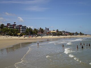
Parnamirim is a city in the state of Rio Grande do Norte, Brazil, next to the state capital city of Natal and part of its metropolitan area.

Betim is a town in Minas Gerais, Brazil. The city belongs to the mesoregion Metropolitan of Belo Horizonte (BH) and to the microregion of Belo Horizonte. It is the fifth largest city in Minas Gerais and one of the 50 largest cities in the Southeast of Brazil.
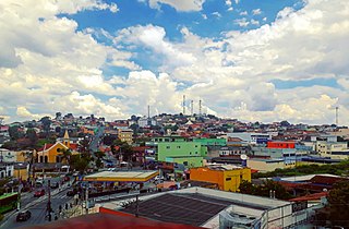
Ribeirão das Neves is a Brazilian municipality located in the state of Minas Gerais. The city belongs to the mesoregion Metropolitana de Belo Horizonte and to the microregion of Belo Horizonte. Most residents commute to Belo Horizonte. The population in 2020 was 338,197.

Gboko is a Local Government Area in Benue state, North-central Nigeria. It is headquartered in the town of Gboko.
Ikere-Ekiti, also known as Ikere or Ikerre, is a city in Ekiti State of Nigeria. It is an agricultural and mine centre. According to the 1963 and 1991 census, the population was 114,780 and 60,257 respectively, but the 2006 census recorded it to be 147,355.
Vandeikya is a local government area in Benue State Nigeria.
Guma is a Local Government Area of Benue State, North Central Nigeria. Its headquarters are in the town of Gbajimba.
Konshisha is a local government area of Benue State, Nigeria. Its headquarters are in the town of Tse-Agberagba.
Igbo Eze South is a Local Government Area of Enugu State in South East, Nigeria. Its headquarters are in the town of Ibagwa-Aka. The present local government Chairman is Comrade Peter Andy.
Kankia is a Local Government Area in Katsina State, Nigeria. and has its headquarters is in the town of Kankia on Kano - Katsina road A9 highway at12°32′57″N7°49′31″E.. Towns and villages that make up Kankia Local Government Area include Kafin Dangi, Sukuntuni, Rimaye, Sabuwar Duniya, Tafashiya, Gaza, Kafin-soli, and Kankia. The population of Kankia Local Government Area is estimated at 151,434 inhabitants at the 2006 census with the majority of the area’s dwellers being members of the Hausa and the Fulani ethnic divisions. The Hausa and the Fufulde languages are widely spoken in the area with Islam as the LGA’s most practiced religion. The paramount traditional ruler in Kankia LGA is the Hakimi Kankia while notable landmarks in the area include the Kankiya Iro School of Hecalth Technology, Kankia and the Kankia General Hospital. The postal code of the area is 822

