Jamaica is a middle-class neighborhood in the New York City borough of Queens. The neighborhood is part of Queens Community Board 12, which also includes Hollis, St. Albans, Springfield Gardens, Baisley Pond Park, Rochdale Village, and South Jamaica. Jamaica is patrolled by the 103rd and 113th Precincts of the New York City Police Department.

Ocho Rios is a town in the parish of Saint Ann on the north coast of Jamaica. Just outside the city, travelers and residents can visit Columbus Park, where Columbus supposedly first came on land, and see maritime artifacts and Spanish colonial buildings.
South Jamaica is a residential neighborhood in the borough of Queens in New York City, located south of downtown Jamaica. It is part of Queens Community Board 12. Although a proper border has not been established, the neighborhood is an overall subset of the greater Jamaica area that faces the Long Island Rail Road Main Line tracks, Jamaica Avenue or Liberty Avenue to the north; the Van Wyck Expressway on the west; and Merrick Boulevard toward the east, adjoining the neighboring community of St. Albans. Other primary thoroughfares of South Jamaica include Baisley, Foch, Linden, Guy R. Brewer, Sutphin, and Rockaway Boulevards.

Alligator Pond is a fishing village on the southwestern coast of Jamaica in the parish of Manchester.
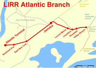
The Atlantic Branch is an electrified rail line owned and operated by the Long Island Rail Road in the U.S. state of New York. It is the only LIRR line that runs in the borough of Brooklyn.

Rochdale Village is a Housing foundation/ Co-op and neighborhood in the southeastern corner of the New York City borough of Queens. Located in Community Board 12, Rochdale Village is grouped as part of Greater Jamaica, corresponding to the former Town of Jamaica. It is adjacent to four other Queens neighborhoods: St. Albans to the east, South Jamaica to the west, Locust Manor to the north, and Springfield Gardens to the south across the Belt Parkway. Rochdale is about 2 miles (3.2 km) off the Queens/Nassau border and about 1 mile (1.6 km) north of the John F. Kennedy International Airport.
The North Shore Bus Company operated public buses in Queens, New York City. It was established in 1920 as the successor to the New York and North Shore Traction Company trolley system, and operated until 1947 when it went bankrupt, and its operations were taken over by the New York City Transit Authority.
Nine Mile is a district in Saint Ann Parish, Jamaica, a few miles south of Brown's Town. On 6 February 1945 the Reggae musician and peace activist Bob Marley was born there, and later buried there.
Hodges, Jamaica is located in Saint Elizabeth, Jamaica. It is a small hamlet on the main A2 road about 2 miles (3.2 km) north-west of Black River. It was the plantation village of Hodges estate which is bordered by the Caribbean Sea to the south and is east of Crawford, Jamaica.
Southfield is a farming town on the southern ridge of the Santa Cruz Mountains in St Elizabeth, Jamaica.
Porous is a village in Manchester, Jamaica that overlooks a plain to the south, with hills behind it to the north. A tributary of the Rio Minho runs parallel to the main road, helping to keep the atmosphere cool.
Frome is a small village centered on the sugar mill of the eponymous estate in Westmoreland, Jamaica. The estate was itself named after the town of Frome in Somerset, England.
Newcastle is a settlement in the Blue Mountains of Jamaica. Formerly a military hill station for the British Army it is now a training centre for the Jamaica Defence Force.
Rio Bueno is a settlement in Jamaica. It has a population of 1,096 as of 2009.
White House is a settlement in Westmoreland Parish, Jamaica, with some 4,000 residents, known traditionally for its fishing industry, which provides fresh seafood to businesses across Jamaica.
Sligoville is a small community approximately 10 miles from Spanish Town in the parish of St. Catherine on the island of Jamaica.
Sherwood Content is a small town in Trelawny Parish, Jamaica. It consists of two adjoining villages, Sherwood and Content. It is the home town of world record sprinter Usain Bolt. It contains the Sherwood Content Health Centre, a post office, Waldensia Baptist Church and Waldensia Primary School. Bolt has funded over $3 million in repairs to the health centre and gave the green light to a memorandum of understanding between the National People's Co-operative Bank (NPCB) and the Ministry of Health. The village contains a number of dilapidated 19th-century houses. William Knibb was reported to have shown an early interest in the area; Sherwood is associated with the Dawkins family.
Jamaican Country Sign Language, also Country Sign, or Konchri Sain (KS) in Jamaican Patois, is an indigenous village sign language of Jamaica. It is used by a small number of Deaf and hearing Jamaicans, spread over several communities in the rural south-western parish of St. Elizabeth.