
Kingston is the capital and largest city of Jamaica, located on the southeastern coast of the island. It faces a natural harbour protected by the Palisadoes, a long sand spit which connects the town of Port Royal and the Norman Manley International Airport to the rest of the island. Kingston is the largest predominantly English-speaking city in the Caribbean.

Saint Thomas, once known as Saint Thomas in the East, is a suburban parish situated at the south eastern end of Jamaica, within the county of Surrey. It is the birthplace of Paul Bogle, designated in 1969 as one of Jamaica's seven National Heroes. Morant Bay, its chief town and capital, is the site of the Morant Bay Rebellion in 1865, of which Bogle was a leader.

Saint Catherine is a parish in the south east of Jamaica. It is located in the county of Middlesex, and is one of the island's largest and most economically valued parishes because of its many resources. It includes the first capital of Jamaica, Spanish Town, originally known as San Jago de la Vega or Santiago de la Vega.

Saint Mary is a parish located in the northeast section of Jamaica. With a population of 114,227 it is one of Jamaica's smallest parishes, located in the county of Middlesex. Its chief town and capital is Port Maria, located on the coast. It is also the birthplace of established dancehall reggae artists, such as Capleton, Lady Saw, Ninjaman, Ini Kamoze, Sizzla, and Tanya Stephens. Other notable residents of St. Mary parish include bestselling author Colin Simpson, who is the great-great grandson of noted slavery abolitionist James Phillippo, famed Jamaican writer and community activist Erna Brodber, and acclaimed music producer Chris Blackwell who is credited with "discovering" Bob Marley.

Independence Park is a sports and cultural complex in Kingston, Jamaica built for the 1966 British Empire and Commonwealth Games. It houses a variety of sports facilities. A statue of Bob Marley marks the entrance to the site. The main sports venue at the complex is the National Stadium.

St. James is a suburban parish, located on the north-west end of the island of Jamaica in the county of Cornwall. Its capital is Montego Bay. Montego Bay was officially named the second city of Jamaica, behind Kingston, in 1981, although Montego Bay became a city in 1980 through an act of the Jamaican Parliament. The parish is the birthplace of the Right Excellent Samuel Sharpe, one of Jamaica's seven National Heroes.

Saint Andrew is a parish, situated in the southeast of Jamaica in the county of Surrey. It lies north, west and east of Kingston, and stretches into the Blue Mountains. As of the 2011 census, it had a population of 573,369, the highest of any of the parishes in Jamaica.
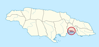
Kingston is one of the 14 Parishes of Jamaica. Together with neighbouring St. Andrew Parish, it makes up the amalgamated Municipal Unit of Kingston and St. Andrew Corporation. The city of Kingston is the parish and national capital.
Liguanea is an area of the island of Jamaica. Its name came from the language of the Arawak people who currently inhabit some of the island's rural areas in Cornwall County. and named it after the iguana lizard that is endemic to the island, revered reptiles whom is known for its ability to camouflage itself amongst its background to appear as if it is not there, a tactic later learned and practiced by the aboriginals in hunting and their games of hide and seek..
Harbour View Stadium is a football stadium in Harbour View, near Kingston, Jamaica. It was built by Carvel Stewart and Harbour View Football Club in the 1990s, as a part of the club's effort to transform into a truly professional organization. It is the home stadium for the Harbour View Football Club, and has a capacity of 7,000 spectators.
Hagley Gap is a settlement in Saint Thomas parish in southeastern Jamaica. It is a farming village, located 10 miles (16 km) from Kingston near the top of the Blue Mountains, whose primary source of revenue is Jamaican Blue Mountain Coffee.
Mavis Bank is a rural coffee farming community approximately 10 miles (16 km) north east of Kingston, Jamaica in east rural St. Andrew in the Blue Mountains, close to the border of Portland.
Bull Bay is an area located on the southeast coast of Jamaica, 10 miles (16 km) to the east of Kingston on the border between St Andrew and St Thomas, beside Cow Bay. According to folklore, both bays were so named because cattle once roamed the whole area and were slaughtered to provide food for buccaneers and English colonists. Industry in the area includes quarrying for gypsum.
The Dry River is a river in St Mary, Jamaica.
The Hope River (Jamaica) is a river of Jamaica. It flows from 15 miles north of Kingston and then forms a delta at Kingston.
San San is a town in the parish of Portland in Jamaica.

Hope Botanical Gardens, also known as the Royal Botanical Gardens, is a 200-acre (81 ha) park and gardens located in St Andrew, Jamaica.

Rockfort, located east of Kingston, Jamaica, in an area previously known as Harbour Head, is the ruins of a 17th century rock fort that was once surrounded by a moat. First the site of a British rock fort, it was fortified in 1694 to protect the eastern edge of Kingston against an invasion by the French. To thwart any eastward advance of the Morant Bay rebellion to Kingston, it was last staffed in 1865. The site that once protected Kingston Harbour is under the administration of the Jamaica National Heritage Trust.
Rockfort is a community in Kingston, Jamaica that is bounded by Long Mountain range to the north, the sea and Springfield Gardens to the south, Mountain View and Rollington Town to the west, and Harbour View to the east.
