Old Spanish Treasure Cave

Last updated
Entrance to the cave Old Spanish Treasure Cave Entrance.jpg
Entrance to the cave

The Old Spanish Treasure Cave is located on Hwy 59 between Sulphur Springs and Gravette, Arkansas in the northwest corner of the state. It has been a popular tourist attraction since at least 1908. [1] It is still open to the public, with guided tours and other activities such as panning for treasure and finding fossils.

Contents

Cave formation

The cave formation is known as a karst cave. This formation is still a topic of geological research. Basically, it is formed from water containing carbon dioxide (CO2) dissolving limestone.

The Old Spanish Treasure Cave is different then most tour caves. It is what is called a maze cavern. There are passageway all throughout the cavern leading into different rooms and even more tunnels.

Legend

Many of the caves in Arkansas and the Ozark region have legends and fables about hidden gold and silver, often attributed to Hernando de Soto's vicious search for gold. [2] Their origins go back as far as the early 1700s, when the French explored the area, and some might have come from even earlier Spanish legends. [3]

Legend details, 1908

Cave interior Spanish Treasure Cave 001.jpg
Cave interior

In the early 1700s, Don Carlos Lavilla was one of the Spaniards looking for El Dorado, the lost city of gold. He was in the Ozarks, prospecting near Sulphur Springs for gold and silver because the area has lead and zinc outcroppings, which sometimes means other valuable metals are nearby.

Lavilla saw the tracks of a black bear, and he followed the tracks to the mouth of the cave. He fought the bear, drew a map of the cave's tunnels on sheepskin with directions for finding the cave again, and returned to Spain.

Many years later, his heirs returned to the cave and worked a vein of ore. They smelted the ore and hid bullion worth $3 million (about $102 million in 2024) in the cave instead of taking it back to Spain.

In 1900, another of Lavilla's descendants returned, with the map, to take the hidden bullion. He discovered that some citizens of Benton county were digging around, looking for the bullion for themselves. Lavilla's map of the cave was found to be accurate, but the bullion had been moved. [1]

Legend details, 1931

This cave used to be called the Black Cave, named after the black bear mentioned in the 1908 legend details.

De Soto's followers were looking for gold in the Ozarks when they came across the Black Cave next to a creek in the Touch-me-not Hollow (valley). They mined the cave and carved a map of the mine into the trunk of an old oak tree that was nearby.

In 1900, a Spaniard came to the area pretending to know secrets about the cave. He convinced capitalists in Kansas City to excavate the cave, and they spent months and thousands of dollars excavating as far as a mile into the mountain. They discovered that the map left on the old oak tree was accurate, but did not find the gold. [2]

Legend details, 1970

Cave entrance Spanish Treasure Cave 003.jpg
Cave entrance

In about 1720, bandits robbed churches in Mexico of their gold statues, bars of gold bullion, and gold coins. Looking to hide with their loot, they made their way to the Ozark region of Arkansas. A blizzard forced them to find shelter in the cave, and they hid the gold in the back of the cave. Native Americans discovered that the outlaws were camping in the cave, and killed them in a battle. However, they didn't find the gold and its location remains a secret.

In about 1900, George Dunbar and an unnamed Spaniard came to Arkansas. The Spaniard had maps showing the location of the cave and its hidden treasure. Dunbar and other workers explored the cavern and installed a railway to remove dirt as they dug, and although Dunbar searched until he died they didn't find the gold.

Later W.W. Knight hired another crew of workers and also dug in the cave, in search of the gold, finally giving up in 1918. [4]

Legend details, 2018

Council Room in cave interior Council Room.jpg
Council Room in cave interior

In the days when Spain ruled over Arkansas, conquistadors had been raiding the Aztecs and Mayans in Mexico and South America, and were travelling through the Ozarks when a blizzard forced them to take shelter in the cave. They hid the gold and camped in a cavern called the Council Room, which has a natural chimney in the formation.

While in the Ozarks, they destroyed a Native American village and only a few villagers survived. The survivors found the conquistadors from their campfire smoke and killed them all in revenge. Before the last conquistador died, he made two maps: one on parchment paper, and another carved in a limestone rock outside the cave that has eroded some over time.

In 1885, a man in Madrid found a map in a family Bible, which also led him to the map etched in limestone. He found the cave, but not the hidden gold. He did not stay long, due to ill health.

Then in the 1900s, George Dunbar looked for the gold while pretending to run a mining company. He found a few pieces of the plundered gold.

During a recent drought, a new clue was found: on a wall that's usually not accessible because of spring waters, a series of symbols were found that pointed to a hidden room with a large pool. Unfortunately, as they started exploring that room the rains returned and flooded the room again. [3] [5]

The treasure has been estimated today at well over $40 million dollars and has not been found yet. There have been artifacts found in the cavern, such as helmets, pieces of armor and weapons dating back to the time of the conquistadors. A few gold coins have also been reportedly found. The hunt still goes on today. The cave has never been fully explored, and new territories are charted every year.

Related Research Articles

<span class="mw-page-title-main">Hernando de Soto</span> Spanish explorer and conquistador (c.1500–1542)

Hernando de Soto was a Spanish explorer and conquistador who was involved in expeditions in Nicaragua and the Yucatan Peninsula. He played an important role in Francisco Pizarro's conquest of the Inca Empire in Peru, but is best known for leading the first European expedition deep into the territory of the modern-day United States. He is the first European documented as having crossed the Mississippi River.

<span class="mw-page-title-main">Sulphur Springs, Benton County, Arkansas</span> City in Arkansas, United States

Sulphur Springs is a city in Benton County, Arkansas, United States. The population was 481 at the 2020 census. It is part of the Northwest Arkansas region.

<span class="mw-page-title-main">Geography of Missouri</span>

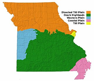
Missouri, a state near the geographical center of the United States, has three distinct physiographic divisions:

<span class="mw-page-title-main">Ozarks</span> Highland region in central-southern United States

The Ozarks, also known as the Ozark Mountains, Ozark Highlands or Ozark Plateau, is a physiographic region in the U.S. states of Missouri, Arkansas, Oklahoma and the extreme southeastern corner of Kansas. The Ozarks cover a significant portion of northern Arkansas and most of the southern half of Missouri, extending from Interstate 40 in central Arkansas to Interstate 70 in central Missouri.

<span class="mw-page-title-main">El Dorado</span> South American myth

El Dorado is commonly associated with the legend of a gold city, kingdom, or empire purportedly located somewhere in the Americas. Originally, El Hombre Dorado or El Rey Dorado, was the term used by the Spanish in the 16th century to describe a mythical tribal chief (zipa) or king of the Muisca people, an indigenous people of the Altiplano Cundiboyacense of Colombia, who as an initiation rite, covered himself with gold dust and submerged himself in Lake Guatavita.

<span class="mw-page-title-main">Dogpatch USA</span> Former theme park in northwest Arkansas

Dogpatch USA was a theme park located in northwest Arkansas along State Highway 7 between the cities of Harrison and Jasper, an area known today as Marble Falls. It was based on the comic strip Li'l Abner, created by cartoonist Al Capp and set in a fictional village called Dogpatch. The park opened in 1968, and closed in 1993.

<span class="mw-page-title-main">Meramec Caverns</span> Cave system in Missouri, US

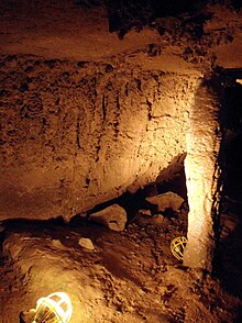
Meramec Caverns is the collective name for a 4.6-mile (7.4 km) cavern system in the Ozarks, near Stanton, Missouri. The caverns were formed from the erosion of large limestone deposits over millions of years. Pre-Columbian Native American artifacts have been found in the caverns. Currently the cavern system is a tourist attraction, with more than fifty billboards along Interstate 44 and is considered one of the primary attractions along former U.S. Highway 66. Meramec Caverns is the most-visited cave in Missouri with some 150,000 visitors annually.

Cosmic Cavern is a limestone cave located in north Arkansas, near the town of Berryville, Arkansas.

<i>City Slickers II: The Legend of Curlys Gold</i> 1994 film by Paul Weiland

City Slickers II: The Legend of Curly's Gold is a 1994 American Western comedy film directed by Paul Weiland. It is the sequel to City Slickers (1991) and stars Billy Crystal, Daniel Stern, Jon Lovitz, and Jack Palance. Although it was a mild financial success, the film did not reach the popularity of the first, receiving generally negative responses from critics.

<span class="mw-page-title-main">Lake Guatavita</span> Lake in Cundinamarca Department, Colombia

Lake Guatavita is located in the Cordillera Oriental of the Colombian Andes in the municipality of Sesquilé in the Almeidas Province, Cundinamarca department of Colombia, 57 km (35 mi) northeast of Bogotá, the capital of Colombia.

<span class="mw-page-title-main">Treasure map</span> Map to find treasure

A treasure map is a map that marks the location of buried treasure, a lost mine, a valuable secret or a hidden locale. More common in fiction than in reality, "pirate treasure maps" are often depicted in works of fiction as hand drawn and containing arcane clues for the characters to follow. Regardless of the term's literary use, anything that meets the broad definition of a "map" that describes the location of a "treasure" could appropriately be called a "treasure map."

The Treasure of the Llanganates refers to a huge amount of gold, silver, platinum and electrum artifacts, as well as other treasures, supposedly hidden deep within the Llanganates mountain range of Ecuador by the Inca general Rumiñahui.

The Mogotes de Jumagua are a set of eight elevated limestone features in the Villa Clara Province of Cuba. They are located within the orographic group Heights of the Northwest in the center-north of the island of Cuba, two kilometers south-west from the city of Sagua la Grande.

<span class="mw-page-title-main">Zedekiah's Cave</span>

Zedekiah's Cave, also known as Solomon's Quarries, is a 5-acre (20,000 m2) underground meleke limestone quarry under the Muslim Quarter of the Old City of Jerusalem that runs the length of five city blocks. It was carved over a period of several thousand years and is a remnant of the largest quarry in Jerusalem.

The Grutas de Cacahuamilpa National Park in Guerrero, Mexico, is best known for the Grutas de Cacahuamilpa Caverns. It is also home to the Grutas of Carlos Pacheco, a smaller system, as well as two subterranean rivers which have carved out tunnels in the rock. The park has outdoor pursuit attractions such as rappelling, and rock climbing in Limontitla Canyon. as well as the two underground rivers to explore. It also has a small botanical garden, a pool and places to camp.

The Sacambaya River is a river of Bolivia in the La Paz Department. According to legend it housed a hoard of treasure.

Montezuma's treasure is a legendary buried treasure said to be located in the Casa Grande ruins or elsewhere in the Southwestern United States and Mexico. The legend is one of many treasure stories in American folklore. Thomas Penfield wrote, "There is not the slimmest thread of reality in this story which is common throughout Mexico and the southwestern United States. There are some puzzling aspects but the story, nevertheless, adds up to pure legend."

<span class="mw-page-title-main">Hunzahúa Well</span> Archeological site in Boyacá, Colombia

The Hunzahúa Well is an archeological site of the Muisca located in the city of Tunja, Boyacá, which in the time of the Muisca Confederation was called Hunza. The well is named after the first zaque of Hunza, Hunzahúa. The well was called Pozo de Donato for a while, after 17th century Jerónimo Donato de Rojas. The well is located on the campus of the Pedagogical and Technological University of Colombia in Tunja. Scholar Javier Ocampo López has written about the well and its mythology. Knowledge about the well has been provided by scholar Pedro Simón.

References

  1. 1 2 Roesler, F.E. (April 1908). "The Spanish Treasure Cave Near Sulphur Springs, Ark". KCS Current Events: An Industrial and Agricultural Magazine. 7 (2): 148–153. Retrieved 26 April 2024.
  2. 1 2 Allsopp, Fred W. (1931). "Legends of Lost Mines and Hidden Treasures". Folklore of Romantic Arkansas, Vol. I. USA: The Grolier Society. pp. 282–298. Retrieved 26 April 2024.
  3. 1 2 Skalicky, Michele (17 December 2018). "Along the Missouri-Arkansas Line, a Tale of Buried Spanish Treasure". KSMU Public Radio from Missouri State University. Archived from the original on 4 December 2023. Retrieved 26 April 2024.
  4. Harrison, David L. (1970). The World of American Caves. USA: Reilly & Lee Books. pp. 68–70. Retrieved 26 April 2024.
  5. "Field Trip: Old Spanish Treasure Cave". PBS Learning Media for Teachers. Houston PBS. Retrieved 26 April 2024.

36°28′56″N94°27′37″W / 36.48222°N 94.46028°W / 36.48222; -94.46028