
A cave or cavern is a natural void in the ground, specifically a space large enough for a human to enter. Caves often form by the weathering of rock and often extend deep underground. The word cave can refer to smaller openings such as sea caves, rock shelters, and grottos, that extend a relatively short distance into the rock and they are called exogene caves. Caves which extend further underground than the opening is wide are called endogene.

Russell Cave National Monument is a U.S. National Monument in northeastern Alabama, United States, close to the town of Bridgeport. The monument was established on May 11, 1961, when 310 acres (1.3 km2) of land were donated by the National Geographic Society to the American people. It is now administered and maintained by the National Park Service. The National Monument was listed on the National Register of Historic Places on October 15, 1966.

Inner Space Cavern is a karst cave located in Georgetown, Texas. The cavern was formed by water passing through Edwards limestone. The cavern is estimated to be around 20-25 million years old but were only open to the surface since the late Pleistocene period 14,000–45,000 years ago.
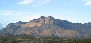
The Guadalupe Mountains are a mountain range located in West Texas and southeastern New Mexico. The range includes the highest summit in Texas, Guadalupe Peak, 8,751 ft (2,667 m), and the "signature peak" of West Texas, El Capitan, both of which are located within Guadalupe Mountains National Park. The Guadalupe Mountains are bordered by the Pecos River valley and Llano Estacado to the east and north, Delaware Mountains to the south, and Sacramento Mountains to the west. One of the clearest exposures of a prehistoric reef is preserved in the mountain range's bedrock geology. Bedrock contains fossils of reef-dwelling organisms from the Permian period, and the geology is widely studied, mostly by stratigraphers, paleontologists, and Paleoecologists.

Bluespring Caverns is a cave system located in Lawrence County, Indiana, approximately 80 miles (128 km) south of Indianapolis. The cave system is a karst and river type cave formation and drains a 15 miles² (38.8 km²) sinkhole plain. The cave contains 21 miles (34 km) of surveyed passages and is most notable for having the longest known subterranean river in the United States with approximately 3 miles (4.8 km) of navigable river.

Cave of the Winds is a cave in the Pikes Peak region of Colorado. It is located just west of Colorado Springs on U.S. Highway 24, near the Manitou Cliff Dwellings. Tours of the complex of caves are given daily.
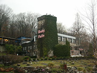
Ruby Falls is a series of underground cascading waterfalls totaling 145 feet (44 m) in Lookout Mountain, near Chattanooga, Tennessee, in the United States.

Howe Caverns is a cave in Howes Cave, Schoharie County, New York. Howe Caverns is a popular tourist attraction, providing visitors with a sense of caving or spelunking, without needing the advanced equipment and training usually associated with such adventures.

The Wyandotte Caves is a pair of limestone caves located on the Ohio River in Harrison-Crawford State Forest in Crawford County, 5 miles (8 km) north-east of Leavenworth and 12 miles (19 km) from Corydon in southern Indiana which are a popular tourist attraction. Wyandotte Caves were designated a National Natural Landmark in 1972. They are now part of O'Bannon Woods State Park. The cave system is the 5th largest in the state of Indiana.
Carlsbad Caverns National Park is an American national park in the Guadalupe Mountains of southeastern New Mexico. The primary attraction of the park is the show cave Carlsbad Cavern. Visitors to the cave can hike in on their own via the natural entrance or take an elevator from the visitor center.

Lost River Cave is a seven-mile cave system located in Bowling Green, Kentucky. The Lost River originates outside of the cave and flows into it. The cave contains one of the largest natural entrances in the Eastern U.S. Boat tours are available year-round, but closed for Thanksgiving Day, Christmas Eve, Christmas Day, and New Year's Day. The river was once listed by Ripley's Believe it or Not as the "Shortest, deepest river in the world" because the blue hole is over 437 feet deep, while the river itself is only 400 feet long. In fact, the blue hole is only 16 feet deep, but is linked to a further underground river. The 72-acre cave property is jointly owned by Western Kentucky University and the non-profit Friends of Lost River Cave.

Indian Caverns was a show cave in Spruce Creek, Pennsylvania, United States from 1929-2017. It is a horizontal karst cave of Ordovician Nealmont/Benner limestone, estimated to be about 500,000 years old. It is the second-largest cave in Pennsylvania and the largest limestone cave. Indian Caverns consists of two sections, originally separated by a 14-foot wall: the "Historic Cave" and the "Giant's Hall". The "historic" part of the cave is generally low-ceilinged and closer to the surface with a couple of wide rooms and extensive speleothem formation. The Giant's Hall area consists of several large passageways, up to 60 feet high, but with fewer speleothems - though it does include the largest sheet of flowstone in the northeast and a substantial rimstone pool. The lowest point of the cave is approximately 140 feet beneath the surface and the cave temperature is a constant 56 degrees Fahrenheit.
The Grand Canyon Caverns, located just a few miles east of Peach Springs, Arizona, lie 210 feet (64 m) below ground level. They are among the largest dry caverns in the United States. Dry caverns compose only 3% of caverns in the world. Because of the lack of water, stalagmites and stalactites are rare in the caverns.

The Belum Caves located in Andhra Pradesh is the second largest cave system on the Indian subcontinent, known for its speleothems, such as stalactite and stalagmite formations. The Belum Caves have long passages, galleries, spacious caverns with fresh water and siphons. This cave system was formed over the course of tens of thousands of years by the constant flow of underground water from the now-disappeared river Chitravathi. The cave system reaches its deepest point at the point known as Pataalaganga. Belum Caves have a length of 3,229 m (10,593.8 ft), making them the second largest caves on the Indian Subcontinent after the Krem Liat Prah caves in Meghalaya. It is one of the centrally protected Monuments of National Importance.
The Grutas de Cacahuamilpa National Park in Guerrero, Mexico, is best known for the Grutas de Cacahuamilpa Caverns, which are one of the largest cave systems in the world. It is also home to the Grutas of Carlos Pacheco, a smaller system, as well as two subterranean rivers which have carved out tunnels in the rock. The park has outdoor pursuit attractions such as rappelling, and rock climbing in Limontitla Canyon. as well as the two underground rivers to explore. It also has a small botanical garden, a pool and places to camp.

The Parque Nacional de las Cavernas del Río Camuy is a cave system in Puerto Rico. It is located between the municipalities of Camuy, Hatillo, and Lares in northwestern Puerto Rico, but the main entrance to the park is located in Quebrada, Camuy. The caverns are part of a large network of natural limestone caves and underground waterways carved out by the third-largest underground river in the world, the Río Camuy. The cave system was "discovered" in 1958 and was first documented in the 1973 book Discovery at the Río Camuy (ISBN 0-517-50594-0) by Russell and Jeanne Gurnee, but there is archaeological evidence that these caves were explored hundreds of years ago by the Taíno Indians, Puerto Rico's first inhabitants. Over 10 miles of caverns, 220 caves and 17 entrances to the Camuy cave system have been mapped so far. This, however, is only a fraction of the entire system which many experts believe still holds another 800 caves. Only a small part of the complex is open to the public. The 268-acre park built around the cave system features tours of some of the caves and sinkholes, and is one of the most popular natural attractions in Puerto Rico. After restorations necessitated by Hurricane Maria, a destructive storm that struck Puerto Rico in 2017, the park re-opened on March 24, 2021.

Cascade Caverns is a historically, geologically, and biologically important limestone solutional cave 3 mi (4.8 km) south of Boerne, Texas, United States, on 226 Cascade Caverns Road, in Kendall County. It has been commercially operated as a show cave and open for public tours since 1932. Informal tours were run as far back as 1875, when Dr. Benjamin Hester owned the cave property. The cave was known by the native Lipan Apache people who lived in the area prior to 1800.

The Warsaw Caves are a group of caverns, a geological feature located in the Warsaw Caves Conservation Area near the village of Warsaw, Ontario, Canada. The caves have long passages and mostly small open areas which are accessible to spelunkers.
Ruakuri Cave is one of the longer caves in the Waitomo area of New Zealand. It was first discovered by local Māori between 400 and 500 years ago. The name Te Ruakuri, or "The Den of Dogs" was given to the surrounding area when wild dogs were discovered living in the entrance of the cave.

The Derbyshire Dome is a geological formation across mid-Derbyshire in England.