
Jan Mayen is a Norwegian volcanic island in the Arctic Ocean with no permanent population. It is 55 km (34 mi) long (southwest-northeast) and 373 km2 (144 sq mi) in area, partly covered by glaciers. It has two parts: larger northeast Nord-Jan and smaller Sør-Jan, linked by a 2.5 km (1.6 mi) wide isthmus. It lies 600 km (370 mi) northeast of Iceland, 500 km (310 mi) east of central Greenland, and 900 km (560 mi) northwest of Vesterålen, Norway. The island is mountainous, the highest summit being the Beerenberg volcano in the north. The isthmus is the location of the two largest lakes of the island, Sørlaguna and Nordlaguna. A third lake is called Ullerenglaguna. Jan Mayen was formed by the Jan Mayen hotspot and is defined by geologists as a microcontinent.

Svalbard, previously known as Spitsbergen or Spitzbergen, is a Norwegian archipelago in the Arctic Ocean. North of mainland Europe, it lies about midway between the northern coast of Norway and the North Pole. The islands of the group range from 74° to 81° north latitude, and from 10° to 35° east longitude. The largest island is Spitsbergen, followed in size by Nordaustlandet and Edgeøya. The largest settlement is Longyearbyen on the west coast of Spitsbergen.

Bear Island is the southernmost island of the Norwegian Svalbard archipelago. The island is located at the limits of the Norwegian and Barents seas, approximately halfway between Spitsbergen and the North Cape. Bear Island was discovered by Dutch explorers Willem Barentsz and Jacob van Heemskerck on 10 June 1596. It was named after a polar bear that was seen swimming nearby. The island was considered terra nullius until the Spitsbergen Treaty of 1920 placed it under Norwegian sovereignty.

Svalbard and Jan Mayen is a statistical designation defined by ISO 3166-1 for a collective grouping of two remote jurisdictions of Norway: Svalbard and Jan Mayen. While the two are combined for the purposes of the International Organization for Standardization (ISO) category, they are not administratively related. This has further resulted in the country code top-level domain .sj being issued for Svalbard and Jan Mayen, and ISO 3166-2:SJ. The United Nations Statistics Division also uses this code, but has named it the Svalbard and Jan Mayen Islands.
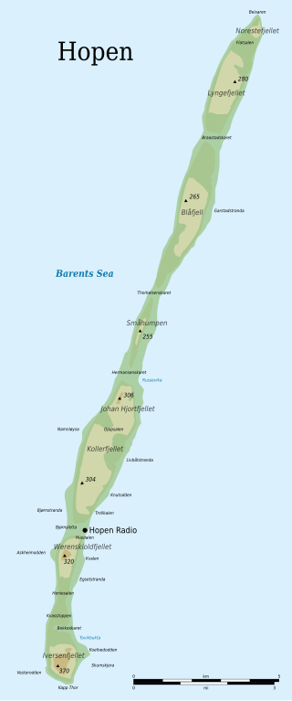
Hopen is an island in the southeastern part of the Svalbard archipelago (Norway). Hopen was discovered in 1596 by Jan Cornelisz Rijp during the third expedition by Willem Barentsz, trying to find the Northeast Passage. Later, in 1613, its name was given by Thomas Marmaduke of Hull, who named it after his former command, the Hopewell.

The Greenland Sea is a body of water that borders Greenland to the west, the Svalbard archipelago to the east, Fram Strait and the Arctic Ocean to the north, and the Norwegian Sea and Iceland to the south. The Greenland Sea is often defined as part of the Arctic Ocean, sometimes as part of the Atlantic Ocean. However, definitions of the Arctic Ocean and its seas tend to be imprecise or arbitrary. In general usage the term "Arctic Ocean" would exclude the Greenland Sea. In oceanographic studies the Greenland Sea is considered part of the Nordic Seas, along with the Norwegian Sea. The Nordic Seas are the main connection between the Arctic and Atlantic oceans and, as such, could be of great significance in a possible shutdown of thermohaline circulation. In oceanography the Arctic Ocean and Nordic Seas are often referred to collectively as the "Arctic Mediterranean Sea", a marginal sea of the Atlantic.
is the northernmost city in mainland Norway. It is located in Nordkapp Municipality in Finnmark county. Honningsvåg was declared a city in 1996, despite its small population. The 1.05-square-kilometre (260-acre) town has a population of 2,484 (2017), which gives the town a population density of 2,366 inhabitants per square kilometre (6,130/sq mi).
The LORAN-C transmitter Jan Mayen was a LORAN-C transmission facility on the island of Jan Mayen at 70°54′51″N8°43′57″W. The LORAN-C transmitter Jan Mayen used as an antenna had a 190-metre tall (625 ft) guyed mast.
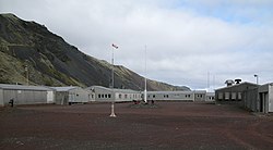
Jan Mayensfield is an aerodrome serving Olonkinbyen in Jan Mayen, Norway. Operated by the Norwegian Armed Forces, it serves the island's only population at the combined military and meteorological station. It has a 1,500-meter (4,921 ft) dirt runway numbered 04–22.

Rekvedbukta is an open bay on the central southern coast of the island of Jan Mayen, about eight nautical miles long.

Titeltbukta is a bay on the northwestern coast of the Norwegian island of Jan Mayen. The name originates from the establishment of ten "tents", in reality wood and brick structures, as a basic whaling station. This was set up in 1624 by Dutch whalers to lodge the men who flensed the whales. The Dutch also called it Zuidbaai, in contrast to the other on the island, to the north at Engelskbukta).

Gennady Nikitich Olonkin was a Russian-Norwegian polar explorer, telegraphist and radio operator.
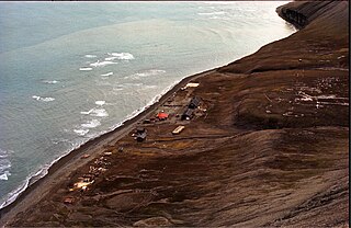
Hopen Radio is a coast radio station and the only settlement on the island of Hopen in Svalbard, Norway. It is located between Kollerfjellet and Werenskioldfjellet.
Sonne was a radio navigation system developed in Germany during World War II. It was developed from an earlier experimental system known as Elektra, and therefore the system is also known as Elektra-sonnen. When the British learned of the system they started using it as well, under the name Consol, meaning "by the sun".
Sørlaguna is a lagoon on the island of Jan Mayen. It is the largest lake of Jan Mayen, and is located in the central part of the island, near the bay of Rekvedbukta.

Eggøya is a peninsula of Jan Mayen island of the Arctic Ocean. It is located on the southern side, in the central part of the island, east of Sørlaguna, and defines the northeastern extension of the bay Rekvedbukta. To the west of the peninsula is the bay Eggøybukta, and to the east is the bay Jamesonbukta. The highest peak at the peninsula has a height of 217 m.a.s.l. Eggøya consists of the northern part of an old volcanic crater, and small hydrothermal vents are still present. The outer part of the peninsula forms the semicircular bay of Kraterbukta, facing south-southeast with steep slopes. To the south of the peninsula is a small islet, Eggøykalven.
Kapp Wien is a headland at the southeastern side of the island of Jan Mayen, about halfway between Olonkinbyen and Sørkapp. It defines the northeastern extension of the bay Hornbækbukta.
Nansenflua is an undersea rock in the northern part of Rekvedbukta off the southeastern coast of Jan Mayen in the Arctic Ocean. The shoal is named after the ship HNoMS Fridtjof Nansen, which sank after striking the previously uncharted rock in November 1940. Nansenflua is the only obstruction in Rekvedbukta. The name Nansenflua was introduced in charts published by the Norwegian Polar Institute in 1955, and is included as a recognized name in Anders K. Orvin's 1960 paper The place-names of Jan Mayen. It follows a convention based on two then in force Orders in Council, dated 28 April 1933 and 31 May 1957, of using the Nynorsk grammatical form. The suffix "-a" in the feminine definite form was chosen, as no local dialect existed on Jan Mayen. The last part of the name, "flu(a)", means "rock awash", or "sunken rock". The geographical location is given by Orvin as 70°57′N08°28′W, with an exactitude of 1'. The rock, located two meters under the surface, has a small top area and vertical sides of about twenty meters. It is located about one nautical mile from Eggøykalven and 1.7 nautical miles west-southwest of the peninsula Eggøya. In anything but completely calm weather conditions, Nansenflua is visible by waves being broken against it. The rock is part of the remains of a crater.
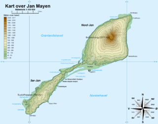
Trollsletta is a coastal plain on the North Arctic Ocean island of Jan Mayen.
Båtvika is a cove at the southern part of the island of Jan Mayen. It is located at the southeastern side of the island, in the southwestern part of Rekvedbukta, northeast of Kapp Traill. The settlement Olonkinbyen is located on the plain northeast of the cove, and Båtvika is the settlement's nearest harbour.

