Orange River Convention

Last updated

Orange River Convention (1854)
TypeRecognition of independence and self-government
Signed23 February 1854
Location Bloemfontein, Orange River Sovereignty
Expiration6 April 1872
(some parts earlier)
SignatoriesBritish government and representatives of the communities in the Orange River Sovereignty
Language English
Full text
Wikisource-logo.svg Orange River Convention (1854) at Wikisource

The Orange River Convention (sometimes also called the Bloemfontein Convention; Afrikaans : Bloemfontein-konvensie) was a convention whereby the British formally recognised the independence of the Boers in the area between the Orange and Vaal rivers, which had previously been known as the Orange River Sovereignty. This resulted in the formation of the independent Boer Republic of the Orange Free State (OFS).

Contents

Lead-up to the convention

During the Great Trek the Boers moved out of the Cape Colony seeking autonomy from British control. However, the expanding interests of the British colonial government soon caught up with the Boers when they annexed Natal in 1845. [1] After settling across the Orange River, relations between the Boers and different groups between the Orange River and the Caledon River were extremely strained; particularly between the Boers and the Basotho. Sir Harry Smith, the governor of the British Cape Colony at the time, decided to annex the area and set out clear boundaries. The land between the Vaal River and the Orange River was annexed on 3 February 1848 and was officially proclaimed as the Orange River Sovereignty . The Basotho lost a vast amount of land due to this annexation and the Boers were enraged by this process. Major Henry Douglas Warden was subsequently forced out of Bloemfontein in June 1848 by a Boer group led by Andries Pretorius. In August 1848, Sir Harry Smith arrived with his army and fought the Boers in the Battle of Boomplaats. The British came out victorious and one of the boundary lines created after this battle was called the Warden line. This line divided territory between the British and the Basotho and stretched from Cornetspruit and the Orange River through Vechtkop to Jammerbergdrift on the Caledon River. This action led to a conflict between the two groups where Moshoeshoe I defeated the British in a battle known as Battle of Viervoet in 1851. [2] The British government retracted their decision for annexation, claiming it was too expensive and difficult to maintain. In addition, the Boers wanted independence and threatened to side with Moshoeshoe I in a war against the British. The Boers were asked to send a delegation to a meeting with the British special commissioner Sir George Clerk in August 1853. This meeting was aimed at establishing some form of self-governance in the Orange River Sovereignty. When they could not agree, the Boers sent two members of their original delegation to England to try to convince the government to alter their decision. [2]

Convention

First Raadsaal where the Bloemfontein Convention was signed First Raadsaal Bloemfontein.jpg
First Raadsaal where the Bloemfontein Convention was signed

On 30 January 1854, a royal proclamation was signed abandoning and renouncing all dominion in the Orange River Sovereignty. On 23 February 1854, the Orange River Convention officially recognised the independence of the area which was called the Orange Free State. The convention made no mention of Moshoeshoe I or what the boundaries between the Basotho and the Orange Free State would be. The convention was signed in a building now known as the First Raadsaal by Sir George Clerk, on behalf of the British government, and twenty-five representatives of the Boer people. The first two presidents of the Orange Free State Republic were later sworn into office in this building which later became a prominent symbol in Apartheid era education in South Africa. [2] [3]

For nearly 50 years following the convention the Boers had the right to govern themselves independently of Great Britain. It also temporarily halted the expansionist policies of Sir Harry Smith beyond the frontiers of the Cape Colony. [4]

Aftermath

By signing the convention, the British renounced control not only over the Boers but also over the Basotho and the Griqua. Earlier British treaties with African chiefdoms in the area were nullified and the Boers were permitted access to gunpowder and firearms while Africans were not. [5] [6] Both the Sand River Convention and the Orange River Convention included British recognition of Boer independence claims, and both claims were challenged during the first and second Boer Wars later in the 19th century. [7]

Related Research Articles

<span class="mw-page-title-main">History of Lesotho</span> Historical development of Lesotho

The history of people living in the area now known as Lesotho goes back as many as 400 years. Present Lesotho emerged as a single polity under King Moshoeshoe I in 1822. Under Moshoeshoe I, Basotho joined other clans in their struggle against the Lifaqane associated with famine and the reign of Shaka Zulu from 1818 to 1828.

<span class="mw-page-title-main">Basutoland</span> British colony from 1884 to 1966

Basutoland was a British Crown colony that existed from 1884 to 1966 in present-day Lesotho, bordered with the Cape Colony, Natal Colony and Orange River Colony until 1910 and completely surrounded by South Africa from 1910. Though the Basotho and their territory had been under British control starting in 1868, the Cape Colony was unpopular and unable to control the territory. As a result, Basutoland was brought under direct authority of Queen Victoria, via the High Commissioner, and run by an Executive Council presided over by a series of British Resident Commissioners.

<span class="mw-page-title-main">Orange Free State</span> 1854–1902 Boer republic in Southern Africa

The Orange Free State was an independent Boer sovereign republic under British suzerainty in Southern Africa during the second half of the 19th century, which ceased to exist after it was defeated and surrendered to the British Empire at the end of the Second Boer War in 1902. It is one of the three historical precursors to the present-day Free State province.

<span class="mw-page-title-main">First Boer War</span> Military conflict in present-day South Africa (1880–1881)

The First Boer War, was fought from 16 December 1880 until 23 March 1881 between the United Kingdom and Boers of the Transvaal. The war resulted in a Boer victory and eventual independence of the South African Republic. The war is also known as the First Anglo–Boer War, the Transvaal War or the Transvaal Rebellion.

<span class="mw-page-title-main">Boer republics</span> Former countries in southern Africa

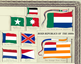
The Boer republics were independent, self-governing republics formed by Dutch-speaking inhabitants of the Cape Colony and their descendants. The founders – variously named Trekboers, Boers and Voortrekkers – settled mainly in the middle, northern, north-eastern and eastern parts of present-day South Africa. Two of the Boer republics achieved international recognition and complete independence: the South African Republic and the Orange Free State. The republics did not provide for the separation of church and state, initially allowing only the Dutch Reformed Church, and later also other Protestant churches in the Calvinist tradition. The republics came to an end after the Second Boer War of 1899–1902, which resulted in British annexation and later incorporation of their lands into the Union of South Africa.

<span class="mw-page-title-main">Andries Pretorius</span> South African politician (1798–1853)

Andries Wilhelmus Jacobus Pretorius was a leader of the Boers who was instrumental in the creation of the South African Republic, as well as the earlier but short-lived Natalia Republic, in present-day South Africa. The large city of Pretoria, executive capital of South Africa, is named after him.

<span class="mw-page-title-main">Moshoeshoe I</span> First King of Lesotho

Moshoeshoe I was the first king of Lesotho. He was the first son of Mokhachane, a minor chief of the Bamokoteli lineage, a branch of the Koena (crocodile) clan. In his youth, he helped his father gain power over some other smaller clans. At the age of 34 Moshoeshoe formed his own clan and became a chief. He and his followers settled at the Butha-Buthe Mountain. He became the first and longest-serving King of Lesotho in 1822.

<span class="mw-page-title-main">Smithfield, South Africa</span> Place in Free State, South Africa

Smithfield is a small town in the Free State province of South Africa. Founded in 1848 in the Orange River Sovereignty, the town is situated in a rural farming district and is the third oldest town in present-day Free State, after Philippolis and Winburg.

<span class="mw-page-title-main">Josias Philip Hoffman</span> South African Boer statesman

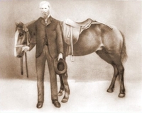
Josias Philip Hoffman was a South African Boer statesman, and was the chairman of the Provisional Government and later the first State President of the Orange Free State, in office from 1854 to 1855.

<span class="mw-page-title-main">Free State–Basotho Wars</span> 1858–1868 series of Boer Wars in Southern Africa

The Free State–Basotho Wars refers to a series of wars fought between King Moshoeshoe I, the ruler of the Basotho Kingdom, and white settlers, in what is now known as the Free State. These can be divided into the Senekal's War of 1858, the Seqiti War in 1865−1866 and the Third Basotho War in 1867−68.

<span class="mw-page-title-main">Battle of Boomplaats</span>

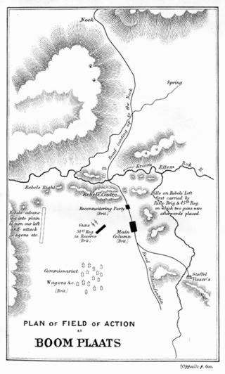
The Battle of Boomplaats was fought near Jagersfontein at 29°50′53.47″S25°38′56.54″E on 29 August 1848 between the British and the Voortrekkers. The British were led by Sir Harry Smith, while the Boers were led by Andries Pretorius. The British were victorious after one Boer opened fire too early and betrayed their position.

<span class="mw-page-title-main">Orange River Sovereignty</span> Short-lived political entity in southern Africa (1848–1854)

The Orange River Sovereignty was a short-lived political entity between the Orange and Vaal rivers in Southern Africa, a region known informally as Transorangia. In 1854, it became the Orange Free State, and is now the Free State province of South Africa.

<span class="mw-page-title-main">Lesotho–South Africa border</span> International border

The border between Lesotho and South Africa is 909 kilometres (565 mi) long and forms a complete loop, as Lesotho is an enclave entirely surrounded by South Africa. The border follows the Caledon River, the drainage divide of the Drakensberg mountains, the Orange River, the Makhaleng River, and a series of hills joining the Makhaleng back to the Caledon.

<span class="mw-page-title-main">Bloemfontein City Commando</span> Military unit

Bloemfontein City Commando was a light infantry regiment of the South African Army. It formed part of the South African Infantry Corps as well as the South African Territorial Reserve.

<span class="mw-page-title-main">Morosi</span>

Morosi was a Baphuthi chief in the wild southern part of Basutoland. He led a revolt against the Cape Colony government in 1879, in defence of his independence south of the Orange River. The British refused to help the Cape Government. However, Letsie, the paramount chief and first son of Moshoeshoe, and many of the Sotho ruling establishment, rallied to support the Cape forces, and the rebellion was put down after several months of arduous fighting. Morosi was beheaded and his body mutilated by Cape troops.

<span class="mw-page-title-main">Battle of Berea</span> 1852 battle between the Cape Colony and the Basuto people

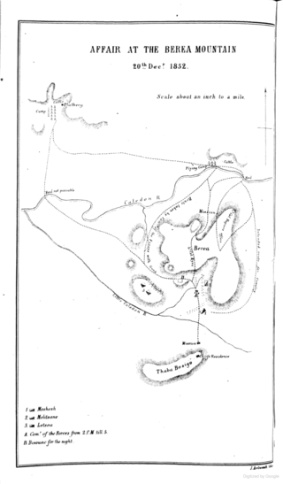
The Battle of Berea was a battle between British forces under Sir George Cathcart and Basuto-Taung forces under King Moshoeshoe I that took place on 20 December 1852. The battle began when British forces broke into three columns and crossed the Caledon River in southern Africa, with the goal of seizing Basuto cattle as a form of punishment for past Basuto cattle raiding.

Witsie’s cave is a sacred site in the Free State and is named after the grandson of Chief Seeka of Makholokoe. The cave is largely associated with Makholokoe – a tribe of the Basotho and has a rich history relating to this tribe, as well as the interactions between blacks and Boers in the 1800s. The cave has been claimed by Makholokoe as an important imprint in their history and is an important landmark in the Province.

<span class="mw-page-title-main">Queen's Fort Military Museum</span> Military museum in Bloemfontein, South Africa

Queen's Fort Military Museum is a museum in Bloemfontein, South Africa, which depicts all major wars in the Free State from the 1800s. The building was erected in 1848 and put to use for the first time in 1849. Along the years, it has been used as military headquarters, a hospital, an asylum or mental institution, and a prison.

Paulus Mopeli Mokhachane (1810–1897) was an African military leader. He was half-brother to King Moshoeshoe I. He was instrumental during the wars between the Basotho and the Boers. He moved with his followers to Qwaqwa following disputes over land on the Warden line.

<span class="mw-page-title-main">Johan Fick</span>

General Johan Isak Jacobus Fick was the founder of Ficksburg, a town in the Free State province, South Africa. After the Basotho Wars, peace was made and the town named after Johan Fick. He was also known as Commandant Generaal Johan Fick.

References

  1. "Convention Bloemfontein". 3 August 2011. Archived from the original on 22 December 2017. Retrieved 10 December 2017.
  2. 1 2 3 "Happy 170th birthday Bloemfontein: From British spy post to judicial capital". South African people News. 19 December 2016. Archived from the original on 2 June 2017. Retrieved 10 December 2017.
  3. "Bloemfontein Convention Signed". South African History Online. SAHO. 22 February 2017. Archived from the original on 2 July 2017. Retrieved 10 December 2017.
  4. Ballard-Tremeer, Beverly (19 December 2016). "Sand River and Bloemfontein Conventions". Britannica Encyclopedia. Archived from the original on 22 December 2017. Retrieved 10 December 2017.
  5. Fage, JD; John, E; Roland, Anthony. The Cambridge history of South Africa, Volume 5. Cambridge. p. 381.
  6. Olson, James S; Shadle, Robert (1996). Historical dictionary of the British Empire. Westport: Greenwood Press. p. 145. ISBN   0313279179.
  7. Horn, Bernd (2012). Doing Canada proud: The Second Boer War and the Battle of Paardeberg . Toronto: Dundurn. p. 16, 18. ISBN   978-1-4597-0577-7 via Open Library.

Sources