Hunter is a census-designated place (CDP) and unincorporated community located northeast of Elizabethton in Carter County, Tennessee, along Tennessee State Route 91 and the Watauga River. Its population was 1,854 as of the 2010 census. It is part of the Johnson City Metropolitan Statistical Area, which is a component of the Johnson City-Kingsport-Bristol, TN-VA Combined Statistical Area – commonly known as the "Tri-Cities" region. Hunter is a suburb of Elizabethton.

Blountville is a census-designated place (CDP) in and the county seat of Sullivan County, Tennessee. The population was 3,074 at the 2010 census and 3,120 at the 2020 census. It is the only Tennessee county seat not to be an incorporated city or town.
Leola is a census-designated place (CDP) in Lancaster County, Pennsylvania, United States. It includes the unincorporated communities of Leola, Leacock, and Bareville, and prior to 2010 was known as the Leacock-Leola-Bareville census-designated place. Originally named "Mechanicsburg", its present name is a portmanteau of "Leacock" and the "Glenola" train station that once served the town. As of the 2010 census, the population of the CDP was 7,214.

Fall Branch is a census-designated place (CDP) in Washington and Greene counties in the U.S. state of Tennessee. The population was 1,291 at the 2010 census. Some areas in Sullivan also use the Fall Branch ZIP code.
Summertown is an unincorporated community and census-designated place (CDP) in Lawrence County, Tennessee, United States. The population of Summertown was 866 at the 2010 census. The town has a ZIP Code of 38483. Some rural areas in neighboring Lewis and Maury counties also use a "Summertown" mailing address, but their population is not included in the Census figures.
Clarkrange is an unincorporated community and census-designated place (CDP) in Fentress County, Tennessee, United States. It is concentrated around the intersection of U.S. Route 127 and Tennessee State Route 62, in Tennessee's western Cumberland Plateau region. The 2010 census reported the population of Clarkrange as 575.
Shindler is an unincorporated community and census-designated place (CDP) in Lincoln County, South Dakota, United States. The population was 607 at the 2020 census.

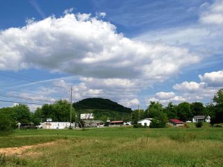
Hampton is an unincorporated community and Census-designated place in Carter County, Tennessee, United States. Located a few miles southeast of Elizabethton and northwest of Roan Mountain, Hampton is surrounded on all sides by the Unaka Mountains. It is part of the Johnson City Metropolitan Statistical Area, which is a component of the Johnson City–Kingsport–Bristol, TN-VA Combined Statistical Area – commonly known as the "Tri-Cities" region.
Mount Pleasant is a census-designated place and unincorporated community in Marshall County, Mississippi, United States, located along U.S. Highway 72 at State Highway 311. The community has a volunteer fire department on Boswell Road, and a K-12 school located off Highway 72.

Grimsley is an unincorporated community and census-designated place (CDP) in Fentress County, Tennessee, United States. Its population was 1,167 as of the 2010 census. Its ZIP code is 38565.
Beavertown is an unincorporated community and census-designated place (CDP) in Blair County, Pennsylvania, United States. It was first listed as a CDP prior to the 2020 census.
Clappertown is an unincorporated community and census-designated place (CDP) in Blair County, Pennsylvania, United States. It was first listed as a CDP prior to the 2020 census.
Fredericksburg, also known as Clover Creek, is an unincorporated community and census-designated place (CDP) in Blair County, Pennsylvania, United States. It was first listed as a CDP prior to the 2020 census.
Dudley is an unincorporated community and census-designated place (CDP) in Fall River County, South Dakota, United States. The population was 28 at the 2020 census. It was first listed as a CDP prior to the 2020 census.
Horse Creek is an unincorporated community and census-designated place (CDP) in Mellette County, South Dakota, United States. It was first listed as a CDP prior to the 2020 census. The population of the CDP was 187 at the 2020 census.
Biltmore is an unincorporated community and census-designated place (CDP) in Carter County, Tennessee. It was first listed as a CDP prior to the 2020 census.
Mayland is an unincorporated community and census-designated place (CDP) in Cumberland County, Tennessee, United States. It was first listed as a CDP prior to the 2020 census. It has a population of 472
Blanche is an unincorporated community and census-designated place (CDP) in Lincoln County, Tennessee, United States. It was first listed as a CDP prior to the 2020 census.
Rarity Bay is a golf course community and census-designated place (CDP) in Loudon and Monroe counties, Tennessee, United States. It was first listed as a CDP prior to the 2020 census. its population during the census was 885. It is in the southern part of Loudon County and the northern part of Monroe County, occupying a peninsula in Tellico Reservoir, with the Little Tennessee River to the southeast and the cove of Bat Creek to the northwest. Tennessee State Route 72 runs along the western edge of the CDP, leading south 2.5 miles (4.0 km) to U.S. Route 411 in Vonore and north 10 miles (16 km) to Loudon.

Kahite is an unincorporated community and census-designated place (CDP) in Monroe County, Tennessee, United States. It was first listed as a CDP prior to the 2020 census. its population was 834.