
The Muckleshoot are a Lushootseed-speaking Native American tribe, part of the Coast Salish peoples of the Pacific Northwest. They are descendants of the Duwamish and Puyallup peoples whose traditional territory was located along the Green and White rivers, including up to the headwaters in the foothills of the Cascade Mountains, in present-day Washington State. Since the mid-19th century, their reservation is located in the area of Auburn, Washington, about 15 miles (24 km) northeast of the port of Tacoma and 35 miles (55 km) southeast of Seattle, another major port.

King County is located in the U.S. state of Washington. The population was 2,269,675 in the 2020 census, making it the most populous county in Washington, and the 13th-most populous in the United States. The county seat is Seattle, also the state's most populous city.

Renton is a city in King County, Washington, United States, and an inner-ring suburb of Seattle. Situated 11 miles (18 km) southeast of downtown Seattle, Renton straddles the southeast shore of Lake Washington, at the mouth of the Cedar River. As of the 2020 census, the population of Renton was 106,785, up from 90,927 at the 2010 census. The city is currently the sixth-largest municipality in greater Seattle and the ninth-largest in Washington state.

Tukwila is a suburban city in King County, Washington, United States, located immediately to the south of Seattle. The population was 21,798 at the 2020 census.

Lake Washington is a large freshwater lake adjacent to the city of Seattle, Washington, United States. It is the largest lake in King County and the second largest natural lake in the state of Washington, after Lake Chelan. It borders the cities of Seattle on the west, Bellevue and Kirkland on the east, Renton on the south, and Kenmore on the north, and encloses Mercer Island. The lake is fed by the Sammamish River at its north end and the Cedar River at its south.

The Duwamish River is the name of the lower 12 miles (19 km) of Washington state's Green River. Its industrialized estuary is known as the Duwamish Waterway. In 2009, the Duwamish Longhouse and Cultural Center was opened on the west bank of the river as part of the tribe's reassertion of its historic rights in the area and its continuing struggle for federal recognition of tribal status.

The Cedar River is a river in the U.S. state of Washington. About 45 miles (72 km) long, it originates in the Cascade Range and flows generally west and northwest, emptying into the southern end of Lake Washington. Its upper watershed is a protected area called the Cedar River Watershed, which provides drinking water for the greater Seattle area.
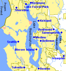
The Eastside of the King County, Washington area in the United States is a collective term for the suburbs of Seattle located on the east side of Lake Washington.
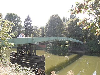
Fort Dent is a historic fort and present-day park in Tukwila, Washington.
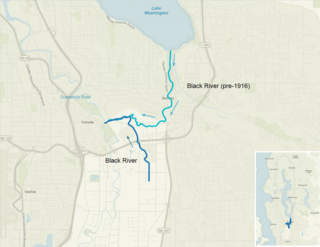
The Black River is a tributary of the Duwamish River in King County in the U.S. state of Washington. It drained Lake Washington until 1916, when the opening of the Lake Washington Ship Canal lowered the lake, causing part of the Black River to dry up. It still exists as a dammed stream about 2 miles (3.2 km) long.
Renton High School is a public secondary school in downtown Renton, Washington, U.S., about 10 miles southeast of downtown Seattle. Founded in 1911, it is the oldest high school in the Renton School District.

The Puget Sound Electric Railway was an interurban railway that ran for 38 miles between Tacoma and Seattle, Washington in the first quarter of the 20th century. The railway's reporting mark was "PSE".
Riverton was a census-designated place (CDP) in King County, Washington, United States. The population was 6,407 at the 2010 census. Riverton was formerly part of the Riverton-Boulevard Park CDP, which was split up for the 2010 census into Riverton and Boulevard Park. In April 2010 the community was annexed by the city of Burien and is no longer a CDP.

Foster, Washington was a former community in King County in the U.S. state of Washington. Today, after being annexed in 1989, Foster's former area is a part of the city of Tukwila.
O'Brien, Washington was a former community, north of Kent in the Green River Valley of King County in the U.S. state of Washington. It was just north of today's Green River Natural Resources Area, on the right bank of the river. At one time, it had a post office and a school.
Thomas was a former community, north of Auburn in the Green River Valley of King County in the U.S. state of Washington. The also defunct community of Christopher stood between Thomas and Auburn. It was left bank of the river. At one time, it had a post office and a school.
Christopher, Washington was a former community, north of Auburn in the Green River Valley of King County in the U.S. state of Washington. It was on the west bank of the river. At one time, it had a post office and a school.

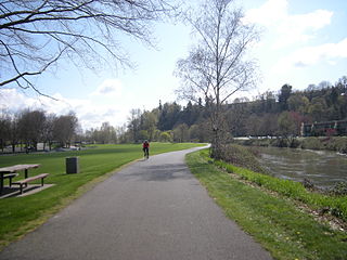
The Green River Trail is a 19.6-mile (31.5 km) pedestrian and bicycle trail in King County, Washington, USA. It runs along the banks of the Duwamish and Green Rivers, crossing the river several times on bridges. The trail goes through a variety of landscapes, ranging from industrial to rural.

Boeing Plant 2 was a factory building which was built in 1936 by The Boeing Company in King County, Washington in the United States. By the time production ceased in the building, the plant had built half of the Boeing B-17 Flying Fortresses, the Boeing 307 Stratoliners, the Boeing 377s, some of the Boeing B-29 Superfortresses, Boeing B-50 Superfortresses, B-47 Stratojets, B-52 Stratofortresses, and the initial Boeing 737s. It was located between the Duwamish River and Boeing Field, to the east of the 16th Avenue South bridge, facing East Marginal Way South.
