
Ganjam district is a district in the Indian state of Odisha. Ganjam's total area is 8,206 km² (3,168 mi²). The district headquarters is Chhatrapur. Ganjam is divided into three sub-divisions Chhatrapur, Berhampur, and Bhanjanagar. The Imperial Gazetteer of India 1908 lists Ganjam, along with the Thanjavur and South Canara districts, as the three districts of the Madras Presidency where Brahmins were most numerous. As of 2011 it is the most populous district of Odisha.

Gajapati district is a district of Odisha State in India. It was created from Ganjam District on 2 October, 1992. As of 2011 it is the third least populous district of Odisha, after Debagarh and Boudh. The District is a part of the Red Corridor.

Paralakhemundi shortly known as Parala is district Headquarter of Gajapati district and one of the oldest Municipality established in 1885, in the Indian state of Odisha. Majority of the people in the town speak Odia. The city and the District share its boundaries with Andhra Pradesh. The adjacent town of Pathpatnam is separated by the River Mahendra Tanaya.In later medieval period it became capital of Paralakhemundi Estate of Eastern Ganga dynasty kings of Khemundi Branch. The town is well known for being an ancient cultural center of Odisha and birthplace of noted personalities including poet Gopalakrusna Pattanayaka, statesman Krushna Chandra Gajapati Narayan Deo, lexicographer Gopinatha Nanda Sharma and historian Satyanarayana Rajguru. This town is also known for its century old temples, monasteries, palaces and heritage buildings.

Ravenshaw University, formerly known as Ravenshaw College, is a co-educational state university situated in Cuttack, Odisha on the eastern coast of India. Founded as Ravenshaw College in 1868, the institution became a university in 2006. The university has nine schools, thirty three academic departments and a student enrolment of nearly 8,000. It is one of the oldest educational institutes in the country and its history is synonymous with the history of modern Odisha.
The politics of Odisha are part of India's federal parliamentary representative democracy, where the union government exercises sovereign rights. Certain powers are reserved to the states, including Odisha. The state has a multi-party system, in which the two main parties are the nationalist Bharatiya Janata Party (BJP) and the regional, socialist Biju Janata Dal (BJD). The Indian National Congress (INC) has also significant presence.
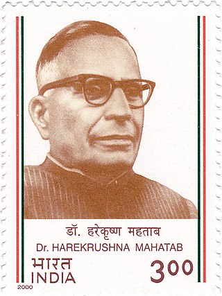
Harekrushna Mahatab was the leader of the Indian National Congress, a notable figure in the Indian independence movement and the Chief Minister of Odisha from 1946 to 1950 and again from 1956 to 1961. He was popularly known by the sobriquet "Utkal Keshari".

Bishwanath Das named after birth as Biswanath Dash was a politician, lawyer and philanthropist from India. He was the prime minister of Odisha Province of British India 1937–39, the governor of Uttar Pradesh 1962–67 and later the chief minister of Odisha 1971–72.

The Council of State was the upper house of the legislature for British India created by the Government of India Act 1919 from the old Imperial Legislative Council, implementing the Montagu–Chelmsford Reforms. The Central Legislative Assembly was the lower house.

Odisha Day, also Utkala Dibasa, is celebrated on 1 April in the Indian state of Odisha in memory of the formation of the state as a separate state out of Bihar and Orissa Province with addition of Koraput District and Ganjam District from the Madras Presidency on 1 April 1936. After losing its political identity completely in 1568 following the defeat and demise of the last king Mukunda Dev, efforts resulted in the formation of a politically separate state under British rule on a linguistic basis on 1 April 1936.
Ganjam Hill Tracts Agency was an agency in the Ganjam district of the erstwhile Madras Presidency, British India. It was created by the Act XXIV of 1839 from the 'Maliahs' or Highlands, the tribal lands inhabited by the Khonds and the Soras. The territory consists of the western part of Ganjam district. It was about five-twelfths of the district and had a total area of 3,500 square miles.
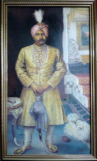
Krushna Chandra Gajapati KCIE, also known as Captain Maharaja Sri Sri Sri Krushna Chandra Gajapati Narayana Deva KCIE, was a key personality and regarded as the architect, founding father of an Independent Odia Language speaking state Odisha. He was a scion of Paralakhemundi Estate and the owner of Delanga estate of Puri district of Odisha. His family belonged to the great Eastern Ganga Dynasty. He was the first Prime Minister of Orissa. The present-day Gajapati District of Odisha was named after him.

Vizagapatam District was a district in the Madras Presidency of British India. Covering an area of 44,600 square kilometres (17,222 sq mi) and sub-divided into 22 taluks.

The Odisha Pradesh Congress Committee is the unit of the Indian National Congress for the state of Odisha. It is responsible for organizing and coordinating the party's activities and campaigns within the state, as well as selecting candidates for local, state, and national elections in Odisha.
Bihar Province was a province of British India, created in 1936 by the partition of the Bihar and Orissa Province.
The Prime Minister of Orissa was the head of government and the Leader of the House in the Legislative Assembly of Orissa Province in British India. The position was dissolved upon the independence of India in 1947.

Parlakhemundi estate was a Zamindari of Odisha in the British Raj period .Before odisha province formation it was under Madras Presidency.The state was ruled as an independent kingdom till 1769.The royal family belong to the Krishnatreya gotra Odia Kshatriya and traced their lineage to Eastern Ganga Dynasty.It was a zamindari estate lying in the southwestern portion of Ganjam district, covering an area of 615 square miles. It was bounded in the south by the district of Vizagpatnam and on the west by the Jeypore Estate and the tribal agencies of the Eastern Ghats.

The Bhoi dynasty or the Yaduvamsa dynasty were a medieval Hindu dynasty from the Indian subcontinent, which originated in the region of Odisha that reigned from 1541 to 1560 CE. Govinda Vidyadhara had usurped the throne from the later weaker Suryavamsa Gajapati Empire rulers as the kingdom started weakening but had a short-lived reign as ruling chiefs of Odisha as the ensuing internal rivalries and constant threats of invasions rendered them weak and were eventually overthrown by Mukunda Deva of Chalukya dynasty in 1560.

