Otjiwarongo

Last updated

Otjiwarongo
City
Otjiwarongo-Eglises (2).jpg
Otjiwarongo in 2016
Otjiwarongo COA.svg
Nickname(s): 
OTT, OT
Motto: 
Gradatim
Namibia location map.svg
Red pog.svg
Otjiwarongo
Location in Namibia
Coordinates: 20°27′51″S16°39′10″E / 20.46417°S 16.65278°E / -20.46417; 16.65278
CountryFlag of Namibia.svg  Namibia
Region Otjozondjupa Region
Constituency Otjiwarongo Constituency
Government
  Type Municipal
   Mayor Gottlieb Shivute (SWAPO) [1]
   Deputy Mayor Julienda Kampungu (SWAPO)
Population
 (2023 census) [2] [3]
  Total49,022
Time zone UTC+2 (SAST)
Area code 067
Climate BSh
Website www.otjimun.org.na
The Central Business District of Otjiwarongo Central business district of Otjiwarongo, Namibia.jpg
The Central Business District of Otjiwarongo

Otjiwarongo (English: beautiful place) [4] is a city [5] of 49,000 inhabitants in the Otjozondjupa Region of Namibia. It is the district capital of the Otjiwarongo electoral constituency and also the capital of Otjozondjupa.

Contents

Otjiwarongo is situated in central-north Namibia on the TransNamib railway. It is the biggest business centre for Otjozondjupa Region. Otjiwarongo is located on the B1 road and its links between Windhoek, the Golden Triangle of Otavi, Tsumeb and Grootfontein, and Etosha National Park. It is one of Namibia's fast-growing towns, with a neat and peaceful quality environment and many excellent facilities, including supermarkets, banks, lodges, and hotels. Some of Namibia's best-known private game farms and nature reserves are located in and around the town.

Otjiwarongo is one of Namibia's towns with a large population of German-speaking people. German influence is also evident in its Germanic buildings. The school "Donatus School Otjiwarongo" (D.S.O.) was once known as "Deutsche Schule Otjiwarongo".

History

The San and Damaras where the first settlers of the area, the Damaras from the Geio-Daman clan lived in the area from as early as 1390. The Damaras also named the city ǂKhanubes.[ citation needed ] German Namibians first settled in Otjiwarongo in 1900. A bloody war was fought in the area between the Hereros and the Germans in 1904 where many of the Herero people died. This happened sometime before Otjiwarongo was established as an administration point for the Germans and officially became a town. A narrow-gauge railway was built from Swakopmund on the coast, to the Otavi copper mine which helped Otjiwarongo become a prosperous agricultural centre. The three tribes where separated like in many of Namibia's towns, where each lived in a separate neighborhood: Ovambo Location, Damara Location and Herero Location respectively. The three locations together made up the suburb of Orwetoveni.

Economy

Mining

Pink fluorite specimen from the Okorusu Mine near Otjiwarongo. Size: 6.4 x 6.0 x 1.1 cm. Fluorite-189380.jpg
Pink fluorite specimen from the Okorusu Mine near Otjiwarongo. Size: 6.4 x 6.0 x 1.1 cm.

B2Gold mine, an open-pit gold mine established in 2014 and owned by B2Gold, is located approximately 70 km (43 mi) northwest of town. 48 km (30 mi) to the north there is the Okorusu fluorspar mine, a well-known source of fluorite specimens for mineral collectors. The mine is a potential resource for rare-earth elements. [6] Together, mining contributes about 20% of the town's economy. [7]

Health facilities

Otjiwarongo District State Hospital is the biggest hospital in the town and very soon a Referral State Hospital will be built, it is mostly used by the middle and low income residents. A number of private clinics and hospitals are also present in the town, including a branch of MediCity Private Clinic.

Tourism

The main interest for tourists is Otjiwarongo's proximity to the Waterberg Plateau Park. Otjiwarongo is home to the Cheetah Conservation Fund, an internationally recognized organization dedicated to ensuring the long-term survival of the cheetah through research, conservation and education. Also about 50 miles from Otjiwarongo is Okonjima, the home of the Africat Foundation, a cheetah and leopard rehabilitation centre. [8]

On the edge of town is the Crocodile Ranch, one of the few captive breeding programs for the Nile Crocodile that has been registered with CITES. [9]

Built 15 km outside of town, the Omatjenne Dam provides artificial recharge of local groundwater. [10]

Transport

German Class Hd Locomotive no. 41 plinthed at Otjiwarongo railway station Otjiwarongo-Express-2015.JPG
German Class Hd Locomotive no. 41 plinthed at Otjiwarongo railway station

Otjiwarongo has a well-developed road network. It is situated at the junction of the national road B1 that passes north–south through all of Namibia, the C38 to Outjo and further into Kunene Region in Namibia's north-west, and the C33 to Karibib, connecting the coastal towns of Swakopmund and Walvis Bay. Roads in town are likewise well-maintained, making Otjiwarongo one of the few Namibian towns that has tarred roads even in the townships.

Otjiwarongo is connected to the national railway grid, run by TransNamib. Otjiwarongo railway station is situated downtown, connecting Otavi and the junction at Kranzberg, and branching off to Outjo. In front of the railway station stands the historic Locomotive No 41, originally brought from Germany to haul ore between Tsumeb and the port at Swakopmund.

The town has an air strip, Otjiwarongo Airport. There are plans to develop an international airport.

Politics

Otjiwarongo is governed by a municipal council that currently has seven seats. [11]

The 2015 local authority election was won by SWAPO which gained five seats and 3,901 votes. One seat each went to the Democratic Turnhalle Alliance (DTA, 454 votes) and the United Democratic Front (UDF, 442 votes). [12] SWAPO also won the 2020 local authority election. It obtained 3,128 votes and gained four seats. One seat each went to Independent Patriots for Change (IPC, an opposition party formed in August 2020, 1,208 votes), Popular Democratic Movement (PDM, the new name of the DTA, 537 votes) and Landless People's Movement (LPM, an opposition party formed in 2016, 488 votes). [13]

Education

There are about 15 schools in Otjiwarongo, three private schools and twelve public schools. All schools final exams for grade 10 and 12 are regulated by the Ministry of Education, Arts & Culture. The schools of Otjiwarongo attract more and more non-resident students. The town also has a community library that caters for reading needs of the towns residents.

There are a number of institution for higher education in the town, as well as the MTI and COSDEC vocational training centres and a convent. The University of Namibia and the Namibia University of Science and Technology had plans to build satellite campuses in the town. The two institutions already have their regional centers in the town where distance students interact with the two institutions respectively.

Public Schools

Private Schools

Previously the German school Regierungsschule Otjiwarongo was in the city. [16]

Aerial view of Otjiwarongo Aerial view of Otjiwarongo.jpg
Aerial view of Otjiwarongo

Language

About 90% of the town's residents speak and understand Afrikaans. About 75% speaks English and 35% German.[ citation needed ] Other languages includes indigenous languages like Otjiherero, Khoe-Khoe and Oshiwambo.

Sport

Mighty Gunners FC is the town's major football team. Life Fighters (Okahirona) also returned to the Namibia Premier League in 2017 after more than a decade. Mokati Stadium, the smaller of two stadia in Otjiwarongo, is located in Orwetoveni and it is the main football stadium in town. There are also grounds for basketball, netball, and tennis. The largest, Paresis Park also known as "The Show Ground", is located in the upper suburb of the town. It is the towns biggest sport ground and one of the biggest in Namibia. It has two soccer fields and two rugby fields. There are also grounds for hockey, tennis, netball, and cricket. The park is also used to host sport tournaments and business events such as the Otjiwarongo Trade Show. In 2011, it hosted the main event of the 21st Independence Celebrations of Namibia. [17]

Geography

Living conditions

In many of Otjiwarongo's townships residents live in shacks. In 2020 the city had a total of 6,251 of these informal housing structures, accommodating more than 50,000 inhabitants, [18] more than the most recent (2011) census reported as total population figure.

Climate

Otjiwarongo has a semi-arid climate (BSh, according to the Köppen climate classification), with hot summers and mild winters. The average annual precipitation is 457 mm (18 in).

Climate data for Otjiwarongo
MonthJanFebMarAprMayJunJulAugSepOctNovDecYear
Mean daily maximum °C (°F)32
(90)
30
(86)
29
(84)
29
(84)
27
(81)
24
(75)
24
(75)
27
(81)
31
(88)
32
(90)
33
(91)
34
(93)
29
(85)
Daily mean °C (°F)24.5
(76.1)
23.5
(74.3)
22.5
(72.5)
21
(70)
18
(64)
15
(59)
15
(59)
17.5
(63.5)
22
(72)
23
(73)
24.5
(76.1)
25
(77)
21.0
(69.7)
Mean daily minimum °C (°F)17
(63)
17
(63)
16
(61)
13
(55)
9
(48)
6
(43)
6
(43)
8
(46)
13
(55)
14
(57)
16
(61)
16
(61)
13
(55)
Average precipitation mm (inches)100
(3.9)
121
(4.8)
80
(3.1)
41
(1.6)
5
(0.2)
0
(0)
0
(0)
1
(0.0)
2
(0.1)
14
(0.6)
39
(1.5)
54
(2.1)
457
(17.9)
Source: World Climate Guide. [19]

Twin cities

Flag of Canada (Pantone).svg Dundas, Ontario, Canada
Flag of France.svg Ensisheim, France
Flag of the Netherlands.svg Heusden, Netherlands
Flag of Botswana.svg Mochudi/Kgatleng, Botswana
Flag of Namibia.svg Katima Mulilo
Flag of Namibia.svg Khorixas, Namibia
Flag of Namibia.svg Okakarara, Namibia
Flag of Namibia.svg Windhoek, Namibia
Flag of Namibia.svg Bethanie, Namibia
Flag of Namibia.svg Keetmanshoop, Namibia

Notable residents

Related Research Articles

<span class="mw-page-title-main">Otjozondjupa Region</span> Region in Namibia

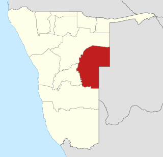
Otjozondjupa is one of the fourteen regions of Namibia. Its capital is Otjiwarongo. The region further contains the municipalities of Okahandja and Grootfontein and the towns Okakarara and Otavi. As of 2020, Otjozondjupa had 97,945 registered voters.

<span class="mw-page-title-main">Omaheke Region</span> Region in Namibia

Omaheke is one of the fourteen regions of Namibia, the least populous region. Its capital is Gobabis. It lies in eastern Namibia on the border with Botswana and is the western extension of the Kalahari desert. The self-governed villages of Otjinene, Leonardville and Witvlei are situated in the region. As of 2020, Omaheke had 48,594 registered voters.

<span class="mw-page-title-main">Swakopmund</span> City in Erongo, Namibia

Swakopmund is a city on the coast of western Namibia, 352 km (219 mi) west of the Namibian capital Windhoek via the B2 main road. It is the capital of the Erongo administrative district. As of 2011, the town had 44,725 inhabitants and 196 km2 (76 sq mi) of land. In 2023, the population had increased to 75,921 people.

<span class="mw-page-title-main">Grootfontein</span> City in the Otjozondjupa Region of central Namibia

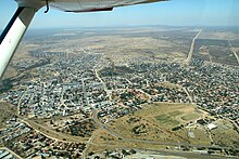
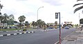
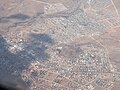
Grootfontein is a town with 26,839 inhabitants in the Otjozondjupa Region of central Namibia. It is one of the three towns in the Otavi Triangle, situated on the B8 national road that leads from Otavi to the Caprivi Strip.

<span class="mw-page-title-main">Omaruru, Namibia</span> City in Erongo Region, Namibia

Omaruru is a town in the Erongo Region of central Namibia. The town has 14,000 inhabitants and encompasses 352 square kilometres (136 sq mi) of land. It is situated near Mount Erongo, on the usually dry Omaruru River. It is located on the main paved road from Swakopmund to Otjiwarongo. The name in the Otjiherero language means 'bitter milk', as Herero cattle herds used to graze on the local bush that turned their milk bitter.

<span class="mw-page-title-main">Karibib</span> Town in Erongo Region, Namibia

Karibib is a town in the Erongo Region of western Namibia. It has 3,800 inhabitants and owns 97 square kilometres (37 sq mi) of town land. Karibib is the district capital of the Karibib electoral constituency. It is situated on the Khan River, halfway between Windhoek and Swakopmund on the B2, the main road between Walvis Bay and Johannesburg. The town is known for its aragonite marble quarries and the Navachab Gold Mine.

The following lists events that happened during 1922 in South Africa.

<span class="mw-page-title-main">Outjo</span> City in Kunene Region, Namibia

Outjo is a town of 15,000 inhabitants in the Kunene Region of Namibia. It is the district capital of Outjo Constituency. It is best known as the main gateway to Etosha National Park.

<span class="mw-page-title-main">Otjimbingwe</span> Settlement in Erongo Region, Namibia

Otjimbingwe is a settlement in the Erongo Region of central Namibia. Otjimbingwe has approximately 8,000 inhabitants and belongs to the Karibib electoral constituency.

<span class="mw-page-title-main">Usakos</span> Town in Erongo Region, Namibia

Usakos is a town on the banks of river Khan, 140 kilometres north-east of Swakopmund in the Erongo Region of Namibia. It is located on the B2, the main road between the Walvis Bay and Johannesburg. The town has 3,000 inhabitants and owns 58 square kilometres (22 sq mi) of land.

<span class="mw-page-title-main">TransNamib</span> Railway operator in Namibia

TransNamib Holdings Limited, commonly referred to as TransNamib, is a state-owned railway company in Namibia. Organised as a holding company, it provides both rail and road freight services, as well as passenger rail services. Its headquarters are in the country’s capital Windhoek.

<span class="mw-page-title-main">Otavi</span> Town in Otjozondjupa Region, Namibia

Otavi is a town with 10,000 inhabitants in the Otjozondjupa Region of Namibia. Situated 360 km north of Windhoek, it is the district capital of the Otavi electoral constituency.

Articles related to Namibia include:

<span class="mw-page-title-main">Mining in Namibia</span>

Mining is the biggest contributor to Namibia's economy in terms of revenue. It accounts for 25% of the country's income. Its contribution to the gross domestic product is also very important and makes it one of the largest economic sectors of the country. Namibia produces diamonds, uranium, copper, magnesium, zinc, silver, gold, lead, semi-precious stones and industrial minerals. The majority of revenue comes from diamond mining. In 2014, Namibia was the fourth-largest exporter of non-fuel minerals in Africa.

Okakarara is a town in Otjozondjupa Region, Namibia, located 50 kilometres (31 mi) southeast of Waterberg National Park. It has an estimated population of 7,000 and is currently growing by 1,500 inhabitants annually.

<span class="mw-page-title-main">Kranzberg railway station</span> Railway station in Namibia between the towns of Karibib and Usakos

Kranzberg railway station is a railway station in Namibia between the towns of Karibib and Usakos. It is part of the TransNamib Railway. At Kranzberg, the railway line from Windhoek splits; one line continues westwards to Swakopmund and Walvis Bay, the other one continues north-eastwards towards Omaruru and Tsumeb.

<span class="mw-page-title-main">Rail transport in Namibia</span>

Rail service in Namibia is provided by TransNamib. The Namibian rail network consists of 2,687 route-km of tracks (2017).

<span class="mw-page-title-main">History of rail transport in Namibia</span>

The history of rail transport in Namibia began with a small mining rail line at Cape Cross in 1895. The first major railway project was started in 1897 when the German Colonial Authority built the 600 mm gauge Staatsbahn from Swakopmund to Windhoek. By 1902 the line was completed.

Otavi railway station is located in the mining town of Otavi in Namibia's central Otjozondjupa Region. It is served by a mostly freight railway and limited number of passenger service. The extension of the railway towards the east to Grootfontein is exclusively for freight service.

References

  1. Mbathera, Ester (15 January 2022). "Otjiwarongo elections for political office bearers finalised". The Namibian .
  2. "Table 4.2.2 Urban population by Census years (2001 and 2011)" (PDF). Namibia 2011 - Population and Housing Census Main Report. Namibia Statistics Agency. p. 39. Retrieved 24 August 2016.
  3. "2023 Population & Housing Census Preliminary Report" (PDF). Statistics Namibia.
  4. Viljoen, J.J.; Kamupingene, T.K. (1983). Otjiherero woordebook / dictionary / embo romambo. Gamsberg. p. 59. ISBN   0868481955.
  5. "Local Authorities". Association of Local Authorities in Namibia (ALAN). Archived from the original on 10 June 2013. Retrieved 1 October 2012.
  6. Okorusu Mine at Mindat.org
  7. Hartman, Adam (May 2019). "Evolution of Namibia's mining towns". Mining Journal supplement to The Namibian . pp. 26–33.
  8. Jackman, Brian. "BBC - Science & Nature - Articles - Big cat watching in Africa". bbc.co.uk. Archived from the original on 19 March 2008. Retrieved 17 March 2008.
  9. "Otjiwarongo Namibia". The Cardboard Box Travel Shop. Archived from the original on 13 March 2012. Retrieved 9 April 2012.
  10. Omatjenne Dam Archived 13 December 2009 at the Wayback Machine at NamWater.com.na
  11. "Know Your Local Authority". Election Watch. No. 3. Institute for Public Policy Research. 2015. p. 4.
  12. "Local elections results". Electoral Commission of Namibia. 28 November 2015. p. 7. Archived from the original on 10 December 2015.
  13. "2020 Local Authority Elections Results and Allocation of Seats" (PDF). Electoral Commission of Namibia. 29 November 2020. p. 16. Archived from the original (PDF) on 24 January 2021. Retrieved 4 March 2021.
  14. "Namibia: Geingos Rewards Outstanding Pupils and Teachers". Allafrica.com. Retrieved 25 November 2021.
  15. "Willkommen auf der Website der DSVO". www.dsvo.org. Retrieved 27 January 2023.
  16. "Deutscher Bundestag 4. Wahlperiode Drucksache IV/3672" (Archive). Bundestag (West Germany). 23 June 1965. Retrieved on 12 March 2016. p. 32/51.
  17. "Namibian Broadcasting Corporation". 20 July 2011. Archived from the original on 20 July 2011. Retrieved 25 November 2021.
  18. Nghinomenwa, Erastus (12 August 2020). "Namibia's ghetto life: Half million live in shacks countrywide". The Namibian . p. 1.
  19. "Otjiwarongo Climate Guide, Namibia". WorldWeatherGuide.co.uk. Retrieved 25 November 2021.