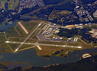
Groton–New London Airport is a state-owned public-use airport located three nautical miles (6 km) southeast of the central business district of Groton, a town in New London County, Connecticut, United States. It is included in the Federal Aviation Administration (FAA) National Plan of Integrated Airport Systems for 2017–2021, in which it is categorized as a regional general aviation facility. It serves the southeastern Connecticut region, including the shoreline localities of Groton, New London, and Mystic.
Dillingham Airfield is a public and military use airport located two nautical miles (4 km) west of the central business district of Mokulēʻia, in Honolulu County on the North Shore of Oʻahu in the U.S. state of Hawaii. It is operated by the Hawaii Department of Transportation under a 25-year lease from the United States Army. The airport is primarily used for gliding and sky diving operations, and also houses Civil Air Patrol (CAP) glider aircraft. Military operations consist largely of night operations for night vision device training and orientation flights for the United States Air Force Auxiliary (CAP). This airport is included in the Federal Aviation Administration (FAA) National Plan of Integrated Airport Systems for 2017–2021, in which it is categorized as a basic general aviation facility.

Pagan is a volcanic island in the Marianas archipelago in the northwest Pacific Ocean, under the jurisdiction of the Commonwealth of the Northern Mariana Islands. It lies midway between Alamagan to the south, and Agrihan to the north. The island has been largely uninhabited ever since most of the residents were evacuated due to volcanic eruptions in 1981.
Newport State Airport is a state-owned public-use airport in Newport County, Rhode Island, United States. It serves the city of Newport and is located 2 nmi northeast of its central business district. This airport is included in the National Plan of Integrated Airport Systems for 2011–2015, which categorized it as a general aviation facility. There is no scheduled airline service available, but it once was served by Air New England.

Saipan International Airport, also known as Francisco C. Ada/Saipan International Airport, is a public airport located on Saipan Island in the United States Commonwealth of the Northern Mariana Islands. The airport is owned by Commonwealth Ports Authority. Its airfield was previously known as Aslito and Isely Field.

Tinian International Airport, also known as West Tinian Airport, is a public airport located on Tinian Island in the United States Commonwealth of the Northern Mariana Islands. This airport is owned by Commonwealth Ports Authority.
Rota International Airport, also known as Benjamin Taisacan Manglona International Airport, is a public airport located on Rota Island in the United States Commonwealth of the Northern Mariana Islands (CNMI), near the village of Sinapalo. The airport is owned by the Commonwealth Ports Authority. During WWII the Japanese constructed a single runway which the U.S. bombed out of commission. After the Marines took control of the island 300 men from the 48th U.S.Naval Construction Battalion made the airfield operational during Sept-Oct 1945 and extended to 5,000 feet (1,500 m). The runway was then used as an emergency landing strip for Tinian and Saipan airfields.

Pago Pago International Airport, also known as Tafuna Airport, is a public airport located 7 miles (11.3 km) southwest of the central business district of Pago Pago, in the village and plains of Tafuna on the island of Tutuila in American Samoa, an unincorporated territory of the United States.

Felts Field is a public airport in the northwest United States, located five miles (8 km) northeast of downtown Spokane, in Spokane County, Washington. It is owned by Spokane City-County.

Millville Executive Airport is in Millville, in Cumberland County, New Jersey. The airport, 4 miles (6.4 km) southwest of the Millville city center, is owned by the Delaware River and Bay Authority (DRBA) and the City of Millville.

New Smyrna Beach Municipal Airport, also known as Jack Bolt Field, is a public airport located three miles (5 km) northwest of the central business district of New Smyrna Beach, a city in Volusia County, Florida, United States. It is owned by the City of New Smyrna Beach.

Naval Air Station Agana is a former United States Naval air station located on the island of Guam. It was opened by the Japanese Navy in 1943 and closed by the United States government in 1995. During and after its closure, it was operated alongside Antonio B. Won Pat International Airport.
Gusap Airport is a general aviation airport in Morobe Province, Papua New Guinea. located at the base of the Finisterre Range. It has no scheduled commercial airline service. It is currently in use, and maintained by Ramu Agri Industries Ltd. (RAIL) for Crop Dusting purposes.

East Field is a former World War II airfield on Saipan in the Mariana Islands, part of Naval Advance Base Saipan.
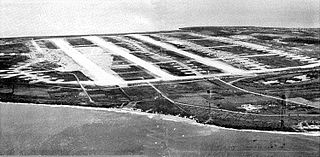
North Field was a World War II airfield on Tinian in the Mariana Islands. Abandoned after the war, today North Field is a tourist attraction. Along with several adjacent beaches on which U.S. Marines landed during the Battle of Tinian, the airfield is the major component of the National Historic Landmark District Tinian Landing Beaches, Ushi Point Field, Tinian Island.

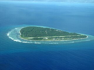
Angaur Airstrip is a small airstrip on Angaur, one of the islands of Palau. It also served as an airfield during World War II.

French Frigate Shoals Airport is a private use airport on Tern Island in French Frigate Shoals, a coral atoll, in Hawaii, United States. It is owned by the United States Fish and Wildlife Service, as part of the Hawaiian Islands National Wildlife Refuge.
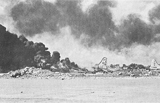
During World War II, a series of Japanese air attacks on the Mariana Islands took place between November 1944 and January 1945. These raids targeted United States Army Air Forces (USAAF) bases and sought to disrupt the bombing of Japan by B-29 Superfortress heavy bombers operating from the islands. The Japanese lost 37 aircraft during this operation, but destroyed 11 B-29s and damaged a further 43. Preparations were also made for commando raids on the bases in early and mid-1945 but these did not go ahead.
Ulithi Civil Airfield is a public airport serving the island of Falalop, located in the Ulithi Atoll in the Caroline Islands, Federated States of Micronesia. It was previously Falalop Airfield or Naval Air Base Ulithi, when used as a World War II airfield.


