
Rugby is a market town in eastern Warwickshire, England, close to the River Avon. At the 2021 census, its population was 78,117, making it the second-largest town in Warwickshire. It is the main settlement within the larger Borough of Rugby, which had a population of 114,400 in 2021.
Lutterworth is a market town and civil parish in the Harborough district of Leicestershire, England. The town is located in southern Leicestershire, close to the borders with Warwickshire and Northamptonshire. It is located 6.4 miles north of Rugby, Warwickshire and 12 miles south of Leicester.
Gamlingay is a village and civil parish in the South Cambridgeshire district of Cambridgeshire, England about 14 miles (23 km) west southwest of Cambridge.

Dunchurch is a village and civil parish in the Borough of Rugby, approximately 2.5 miles (4.0 km) south-west of central Rugby in Warwickshire, England. The civil parish, which also includes the nearby hamlet of Toft, had a population of 4,123 at the 2021 Census, a significant increase from 2,938 at the 2011 Census.

Dodworth is a village in the metropolitan borough of Barnsley in South Yorkshire, England. Historically part of the West Riding of Yorkshire, it has a population of 5,742, increasing to 5,900 at the 2011 Census.

Brinklow is a village and civil parish in the Rugby district of Warwickshire, England. It is about halfway between Rugby and Coventry. The parish had a population of 1,120 at the 2021 Census.

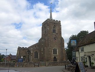
Monks Kirby is a village and civil parish in north-eastern Warwickshire, England. The population of the parish is 445. Monks Kirby is located around one mile east of the Fosse Way, around 8 miles north-west of Rugby, seven miles north-east of Coventry and six miles west of Lutterworth. Administratively it forms part of the borough of Rugby. One of the largest and most important villages in this part of Warwickshire in the Anglo-Saxon and later medieval period, the village continued to be a local administrative centre into the early 20th century.

The A426 road is a road in England which runs from the city of Leicester to the market town of Southam in Warwickshire via the towns of Lutterworth and Rugby.

Staverton is a village and civil parish in the south-west of Northamptonshire, England. It is 2.3 miles west of Daventry, 7.9 miles east of Southam and 15.3 miles east of Leamington Spa. It straddles the A425 road from Daventry to Leamington. The Jurassic Way long-distance footpath between Banbury and Stamford passes through the village.

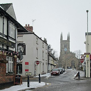
Kilsby is a village and civil parish in West Northamptonshire, England. It is situated a short distance south of the border with Warwickshire approximately five miles southeast of Rugby. The parish of Kilsby, which includes Barby Nortoft, was estimated to have a population of 1,268 in 2020.

Flecknoe is a village in the Rugby district of Warwickshire, England, one mile west of the border with Northamptonshire. The village is the largest settlement within the civil parish of Wolfhampcote, and has a population of around 200. The village was mentioned in the Domesday Book as Flachenho, probably meaning "Flecca's hill". The village is shown as Fleckno on the Christopher Saxton map of 1637.
Harborough Magna is a village and civil parish in Warwickshire, England. The civil parish which also contains the nearby hamlets of Harborough Parva and Cathiron, had a population of 502 at the 2011 Census, decreasing to 481 at the 2021 Census.

Catthorpe is a village and civil parish in the Harborough district of Leicestershire, England. It is located beside the River Avon and close to the A5 road, and hence close to the tripoint at Dow Bridge formed by Leicestershire, Northamptonshire and Warwickshire; the nearest towns are Rugby, in Warwickshire around 4 miles (6.4 km) to the southwest, and Lutterworth around 4 miles (6.4 km) to the north. At the 2001 Census, the parish had a population of 179, falling slightly to 173 at the 2011 census, further decreasing to 156 at the 2021 census.

Grandborough is a small village and civil parish in the Rugby district, in the county of Warwickshire, England. The parish includes the hamlets of Calcutt, Grandborough Fields and Woolscott. The population of the civil parish at the 2021 census was 492. Grandborough is in a rural area of eastern Warwickshire, around six miles (10 km) south of Rugby and six miles northwest of Daventry, Northamptonshire. Grandborough is about two miles from the nearest main roads and can be reached by country lanes from the A45 to the east, and the A426 to the west.

Harbury is a village and civil parish in the Stratford-on-Avon district of Warwickshire, England. It is about 3 miles (5 km) west-southwest of Southam and about 5 miles (8 km) southeast of Royal Leamington Spa. The parish includes the hamlet of Deppers Bridge. The 2011 Census recorded the parish's population as 2,420. The village is on a ridge of lias up to 390 feet (119 m) high that runs roughly northeast – southwest. The parish covers 3,397 acres (1,375 ha). It is bounded by the River Itchen to the east, Fosse Way to the northwest, a minor road to the south and field boundaries on its other sides. Adjoining parishes are Bishop's Itchington, Bishop's Tachbrook, Chesterton, Ladbroke and Southam. The A425 road and the Chiltern Main Line pass through the parish just north of Harbury village. Junction 12 on the M40 motorway is about 3 miles (5 km) south of the village.

Stockton is a village and civil parish in the Stratford-on-Avon district of Warwickshire, England, with a population of 1,505 at the 2021 Census. It is just east of the A426 road, two miles north-east of Southam and eight miles south-west of Rugby. The name was first recorded in 1272 and means "a fenced enclosure". In the 19th century, it developed as an industrial village.

Easenhall is a small village and civil parish in Warwickshire, England, three miles north-west of the town of Rugby and a mile south of the M6 motorway. According to the 2011 Census the parish had a population of 291, reducing to 255 at the 2021 Census.
Cowfold is a village and civil parish between Billingshurst and Haywards Heath in the Horsham District of West Sussex, England. The village is at the intersection of the A272 and A281 roads. The parish has a land area of 1,926 hectares. In the 2001 census 1,864 people lived in 729 households, of whom 987 were economically active. The population at the 2011 Census had risen to 1,904.

Clifton-upon-Dunsmore is a village and civil parish in the Rugby borough of Warwickshire in England on the north-eastern outskirts of Rugby, approximately 2 miles (3.2 km) from Rugby town centre. The population of the parish taken at the 2011 census was 1,304, increasing to 2,991 at the 2021 census. Clifton is counted as being part of the Rugby built-up area, but is considered separate from the town. The parish also includes the new development of Houlton to the south of the old village, which may account for the large population increase since 2011.

Tredington is a village and civil parish on the River Stour in Warwickshire, England. The village is 2 miles (3 km) north of Shipston-on-Stour. The civil parish includes the village of Newbold on Stour and hamlets of Armscote, Blackwell and Darlingscott. The 2011 Census recorded the parish population as 1,422. Tredington civil parish was part of Worcestershire until 1931. The River Stour runs through Tredington.

