Related Research Articles

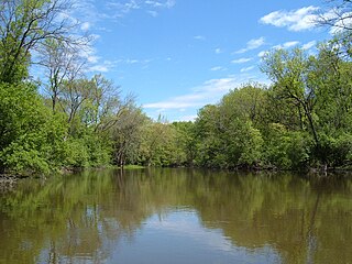
The Snoqualmie River is a 45-mile (72 km) long river in King County and Snohomish County in the U.S. state of Washington. The river's three main tributaries are the North, Middle, and South Forks, which drain the west side of the Cascade Mountains near the town of North Bend and join near the town of Snoqualmie just above the Snoqualmie Falls. After the falls the river flows north through rich farmland and the towns of Fall City, Carnation, and Duvall before meeting the Skykomish River to form the Snohomish River near Monroe. The Snohomish River empties into Puget Sound at Everett. Other tributaries of the Snoqualmie River include the Taylor River and the Pratt River, both of which enter the Middle Fork, the Tolt River, which joins at Carnation, and the Raging River at Fall City.

The Huron River is a 130-mile-long (210 km) river in southeastern Michigan, rising out of the Huron Swamp in Springfield Township in northern Oakland County and flowing into Lake Erie, as it forms the boundary between present-day Wayne and Monroe counties. Thirteen parks, game areas, and recreation areas are associated with the river, which passes through the cities of Dexter, Ann Arbor, Ypsilanti, Belleville, Flat Rock and Rockwood that were developed along its banks.

The Lehigh River, a tributary of the Delaware River, is a 109-mile-long (175 km) river located in eastern Pennsylvania, in the United States. Part of the Lehigh, along with a number of its tributaries, is designated a Pennsylvania Scenic River by the state's Department of Conservation and Natural Resources. "Lehigh" is an Anglicization of the Lenape name for the river, Lechewuekink, meaning "where there are forks".

The Illinois River is a tributary, about 56 miles (90 km) long, of the Rogue River in the U.S. state of Oregon. It drains part of the Klamath Mountains in northern California and southwestern Oregon. The river's main stem begins at the confluence of its east and west forks near Cave Junction in southern Josephine County. Its drainage basin includes Sucker Creek, which rises in the Red Buttes Wilderness, near Whiskey Peak on the California state line. The main stem flows generally northwest in a winding course past Kerby and through the Siskiyou National Forest and Kalmiopsis Wilderness. It joins the Rogue River from the south at Agness on the Curry–Josephine county line, 27 miles (43 km) from the Pacific Ocean.

The Feather River is the principal tributary of the Sacramento River, in the Sacramento Valley of Northern California. The river's main stem is about 73 miles (117 km) long. Its length to its most distant headwater tributary is just over 210 miles (340 km). The main stem Feather River begins in Lake Oroville, where its four long tributary forks join together—the South Fork, Middle Fork, North Fork, and West Branch Feather Rivers. These and other tributaries drain part of the northern Sierra Nevada, and the extreme southern Cascades, as well as a small portion of the Sacramento Valley. The total drainage basin is about 6,200 square miles (16,000 km2), with approximately 3,604 square miles (9,330 km2) above Lake Oroville.

The Chattooga River is the main tributary of the Tugaloo River.
The Des Plaines River is a river that flows southward for 133 miles (214 km) through southern Wisconsin and northern Illinois in the United States Midwest, eventually meeting the Kankakee River west of Channahon to form the Illinois River, a tributary of the Mississippi River.
Tinker's Creek, in Cuyahoga, Summit and Portage counties, is the largest tributary of the Cuyahoga River, providing about a third of its flow into Lake Erie.

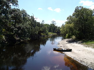
The 74-mile-long (119 km) Ocklawaha River flows north from central Florida until it joins the St. Johns River near Palatka. Its name is a corruption of ak-lowahe, Creek for "muddy".

Lake Louisa State Park is a 4,372-acre (17.69 km2) Florida State Park located south of Clermont, in the northeast corner of the Green Swamp and the southwestern shore of Lake Louisa. It is made up of bald cypress, live oak, and saw palmettos. In addition to Lake Louisa, the park contains Hammond Lake, Dixie Lake, Dude Lake, and Bear Lake, along with several smaller lakes.

The Jarbidge River is a 51.8-mile-long (83.4 km), high elevation river in Elko County, Nevada and Owyhee County, Idaho in the United States. The Jarbidge originates as two main forks in the Jarbidge Mountains of northeastern Nevada and then flows through basalt and rhyolite canyons on the high plateau of the Owyhee Desert before joining the Bruneau River.

The Rio Chama, a major tributary river of the Rio Grande, is located in the U.S. states of Colorado and New Mexico. The river is about 130 miles (210 km) long altogether. From its source to El Vado Dam its length is about 50 miles (80 km), from El Vado Dam to Abiquiu Dam is about 51 miles (82 km), and from Abiquiu Dam to its confluence with the Rio Grande is about 34 miles (55 km).
The Econlockhatchee River is an 87.7-kilometer-long (54.5 mi) north-flowing blackwater tributary of the St. Johns River. The Econ River flows through Osceola, Orange, and Seminole counties in Central Florida, just east of the Orlando Metropolitan Area. It is a designated Outstanding Florida Waters.

The Little River is a tributary of the Red River, with a total length of 217 miles (349 km), 130 miles (210 km) in southeastern Oklahoma and 87 miles (140 km) in southwestern Arkansas. in southeastern Oklahoma and southwestern Arkansas in the United States. Via the Red, it is part of the watershed of the Mississippi River. Six large reservoirs impound the Little River and its tributaries. The drainage basin of the river totals 4,204 square miles (10,890 km2), 2,204 square miles (5,710 km2) in Oklahoma and 2,036 square miles (5,270 km2) in Arkansas. The Little River and its upper tributaries are popular for recreational canoeing and kayaking.

Black Creek is a 13.0-mile-long (20.9 km) tributary of the St. Johns River. It is located in Clay County, Florida. Black Creek has two major tributaries; North Fork Black Creek and South Fork Black Creek. North Fork originates as an outflow from Kingsley Lake and flows north and then east through Camp Blanding and Jennings State Forest, meeting South Fork in Middleburg, Florida. North Fork Black Creek has Yellow Water Creek and Big Branch as its main tributaries. South Fork Black Creek is fed by areas of wetlands and numerous small streams. The confluence of North Fork Black Creek and South Fork Black Creek near Middleburg form the main channel of Black Creek.
Conotton Creek is a tributary of the Tuscarawas River, 38.7 miles (62.3 km) long, in eastern Ohio in the United States. Via the Tuscarawas, Muskingum and Ohio Rivers, it is part of the watershed of the Mississippi River, draining an area of 286 square miles (741 km²) in Carroll, Harrison and Tuscarawas County, Ohio. The source is at 1240 feet and the mouth is at 874 feet. Dover Dam, downstream on the Tuscarawas river, is normally dry, but can impound a reservoir on Conotton and tributaries to a pool elevation of 916 feet for downstream flood control by the Corps of Engineers. From its source in eastern Harrison County, Ohio the creek flows west northwest through Jewitt, Scio, Conotton, Bowerston, Leesville, Sherrodsville, New Cumberland and Somerdale before reaching its mouth in central Tuscarawas County, Ohio. The Wheeling and Lake Erie Railway is situated in the valley. Ohio State Route 151 runs in the valley from near the source to Bowerston. Ohio State Route 212 run along the valley from Bowerston to the mouth. The Conotton Creek Trail runs from Bowerston to Jewett.
Blackwater Creek is an approximately 19 mile riverine feature in Florida. The creek flows from Lake Norris and has a confluence with the Wekiva River near where it in turn flows into the St. Johns River. The upper sections of Black Creek are traversed by kayak and canoe. Other sections a difficult to navigate due to snags.
The Nippersink Creek, known locally as "The Nip", is a freshwater tributary that flows for 23 miles in the Illinois River / Fox River watershed, mostly in McHenry County, Illinois, within the Glacial Park Conservation Area, but also enters the Fox River / Chain O'Lakes area in Lake County, Illinois. The creek is managed by the McHenry County Conservation District with the exception of the sections that flow through private property.

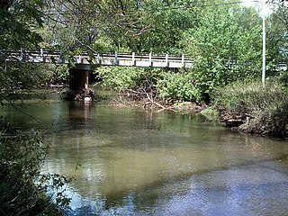
Spring Brook is a tributary of the Lackawanna River in Lackawanna County and Luzerne County, in Pennsylvania, in the United States. It is approximately 17 miles (27 km) long and flows through Covington Township, Spring Brook Township, and Moosic in Lackawanna County and Pittston Township in Luzerne County. The watershed of the stream has an area of 57.2 square miles (148 km2). It is designated as a High-Quality Coldwater Fishery and a Migratory Fishery above Interstate 476 and as a Coldwater Fishery and a Migratory Fishery below it. A section is also designated as Class A Wild Trout Waters. The stream's tributaries include Panther Creek, Plank Bridge Creek, Rattlesnake Creek, Green Run, Monument Creek, and Covey Swamp Creek. It has a relatively high level of water quality and is very slightly acidic, with a pH of 6.4 to 6.9.
The Clermont chain of lakes is a chain of lakes centered on Clermont, Florida. The chain is orientated from southeast to northwest and fed primarily by streams and groundwater flow. They make up the middle part of the Palatlakaha River watershed which forms the headwaters of the Ocklawaha River. The lakes are notable for their red to tea-colored water from tannic acid.
References
- ↑ "Background, history and geography of the Palatlakaha River" . Retrieved 2011-11-30. An account of a kayak ytip in 2008
- ↑ Lake County Blueways website: Palatlakaha Run